Construction of a geographical database of archaic-classical artefacts,
found in the survey of the Greek colony Himera (Sicily, Italy).
Application and methodologies for an experimental research.
M. A. Papa a, , V. Tardoa
a
Università degli Studi di Palermo, Laboratorio di Topografia Antica
KEY WORDS: Survey, Pottery distribution, Database, GIS Intersite, Spatial analysis
ABSTRACT:
This research has analysed the distribution of ceramic finds from classical and archaic ages in the territory of the ancient Greek colony Himera, a town situated near Termini Imerese, in the province of Palermo (Sicily, Italy), which has been the site of systematic excavations carried out by the University of Palermo since the Sixties.
The study of about 1500 ceramic fragments, dated back to the 6th-5th century B.C., has allowed to develop an approach to the understanding of the role played by ceramics in the relations between different societies and cultures.
Besides the most common analysis factors for the ceramic manufactures, such as their production and distribution, a major factor is the way the manufactures were used. From this wider perspective, a new methodology has been developed about information potential of functional analysis.
The interpretation of data about the manufacture distribution was made by means of GIS methodologies, querying the alphanumerical classification database and relating the manufacture typological data to the geo-cartographic ones by means of applying intersite-level spatial analysis. Thus, each archaeological piece of information about the finds can be analysed in relation to the territory geo-morphological features and the obtained data can be processed with specific software environments, in order to suggest reconstruction models for the anthropic landscape, based on the relation between coeval sites and distance from specific environment features – for example, distance from water sources, raw materials, road condition etc.
The computer application used for data handling, presentation and analysis, becomes this way a tool of research aimed at the comprehension of settlement dynamics in the historical scenery. This study is the occasion to propose such an analysis system of cultural heritage as a new tool to promote it and to increase its value, applying a territorial context related methodology founded on scientific evidence.
1. INTRODUCTION
We are here presenting the methodology and results of a pottery study in the territory of the Calcidese colony of Himera. The research objective was to analyse the distribution of superficial findings, both to locate the territorial circulation of these
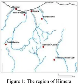
circulation (Bresson 2007) – the research regarded also their consumption, that is the way an object is used and the variety of its possible uses [Bats 1988; Ruby 1993], strictly connected to the role that it plays in society. Therefore, it is important to emphasize the methodological aspects, and not just the results, reckoning with the innovative information technologies in the research planning and the future development of ancient pottery studies. The territory covered by the analysed findings extends between the valleys of the rivers Imera, Torto and St. Leonardo (Figure 1).
Figure 1: The region of Himera
The area – well known from the last thirty year publications issued by the archaeological section of the “Dipartimento Beni Culturali” (Cultural Heritage Department) at Palermo University (Burgio 2002) - measures about 80 square kilometres and encloses (from East to West): an area between the Imera and Torto rivers, up to the low valley of Imera, and in its medium and high valley; the area to the East of Imera, to the torrent Roccella near the hill of Campofelice; and finally the territory between the medium valley of St. Leonardo and the low valley of Torto. The Greek colony of Himera is located in the province of Palermo (Sicily), just a few kilometres from the centre of Termini Imerese (Figure 2). The site has been object of excavations since the Sixties, and extends mainly on a territory not inhabited in modern ages .
Figure 2: The territory of ancient colony of Himera
2. SPATIAL ARCHAEOLOGY
AND POTTERY DISTRIBUTION
Sharing the methodological assumption of
spatial archaeology – that is the research of
information in the spatial distribution of objects in a site or region – we have tried to work out a new interpretative paradigm, which could be added and integrated into the already known ones, both as regards the reconstruction of domestic activities and as for the analysis of various forms of contact among different cultures at territorial level (Nevett 2009; Millet 2000; Belvedere 2000; Cahill 2002).
Applying computer support was a useful way to surpass the idea of simply documenting the findings with an inter-disciplinary vision, while the mapping of distribution was considered as a work tool rather than a synthesis of collected data. From spatial archaeology to Binfordian anthropology, the need of a contextual study is a common landmark.
groups, can be considered as a cultural mediator between different communities. Therefore, beside the classification process, particular attention was addressed to functional analysis of the findings. Taking inspiration from Michel Bats and Bruno D’Agostino’s works, an “integrated approach” between classification systems and functional typologies is being suggested: the functional aspect of pottery was used, in fact, in an experimental way as a conforming element to the variety of topographical contexts in the territory.
3. TECHNICAL REFERENCE
Only materials coming from superficial findings were analysed. A quantity approach (finding count) was combined with a qualitative approach (shape, production, function, chronology) in order to highlight and use a specific requisite of the topographical data: distribution.
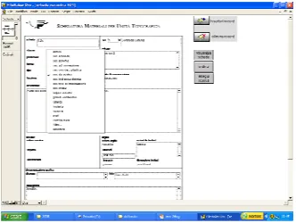
All archaic and classical findings, published and unpublished, were taken into consideration by also examining the published data according to the new classification criteria, also comprehending new research profiles, among which the functional one has been given prominence. The findings were filed using a database realized with FileMaker Pro, containing the most significant parameters for the set objectives (Figure 3).
Figure 3: The Database
FileMaker Pro is a software for database
development which is both powerful and user-friendly, thanks to its pleasant and simple user interface. Since the application doesn’t require programming, it can be considered a RAD tool (Rapid Application Development), which automates complex operations like querying a database, creating reports and masks, manipulating entities and tables, also in .xls format, and much more. The application can also be used as a front-end for the most common alphanumerical archives from websites and mobile devices. The flexibility of this product has allowed to highlight the relation between pottery documentation and territory. Therefore, instead of numbering each finding as an isolated entity, we have tried to identify its meaning within the context in which it was found. For this reason, the system was called “Material Filing for Topographical Unit”. In the findings record, elements commonly used for classifications have been inserted in a drop-down list: class, production, shape, type, and in addition to them also the “function” element. The class was defined according to different criteria, following a common procedure for pottery studies: for some groups the exterior appearance was evaluated (black glazed, stripped), other ones are functional grouping (big storage containers and products transport, transport amphoras, lamps, loom weights). Some others are self-standing groups, well known to the field literature (ionic cup, indigenous painted pottery).
In the “function” field, reference was made to the categories already known from specific publications, distinguishing, where possible, more elements referring to the same activities, since many ancient pots may have been used for various functions, whereas the ancient use of others is not thoroughly known (Amyx 1958; Cazzella 1999; Schreibler 1999).
bibliography, which can be freely extended for explanations.
The study of pottery distribution and the different levels of interpretation have been carried out on the basis of preliminary queries to the classification database, and later, linking the first to the cartographic database, which refers to the territory the pottery comes from.
The cartographic database is handled within the GIS framework developed from the “Laboratorio di Topografia Antica” (Ancient Topography Laboratory) of Palermo University. Development of the GIS framework for the study of the Himera territory is based upon the idea of a GIS integrated into the archaeological data which has proved its efficiency and validity in the context of territorial analysis for ancient landscape reconstruction.
These methodologies made it possible to acquire, manage and analyse graphical and alphanumerical territorial information, in order to comprehend and historicize, within a precisely defined geographical area, the relationships between the human communities which settled there and their relation to the territory.
The archaeological datum of prospecting in the territories of the ancient colony of Himera, is therefore available nowadays and can be analysed through GIS methodologies, suitable for territorial analysis and can be added to geo-morphological, geological, pedological information, and more. ARC MAP 9.0 from ESRI is the software used for the GIS framework. This programme is able to manage CAD raster and vector spatial data, integrating them to alphanumerical data stored in tables. The opportunity of relating, within the framework, the Filemaker Pro database to the archaeological layer spatial information, defined through Topographical Unit numbers, enables us, by simple “join” operations, to obtain connections which allow visualisation of different classes of material distribution in the analysed territory. Therefore, the software wasn’t used just for data handling, but also for its analysis.
The used parameter and the executed queries have enabled us to examine the distribution of archaeological manufactures not only from the centre-periphery point of view, that is between the colony of Himera and its territory, but also from the point of view of a “territorial system”, in which polis and territory are part of the same system of cultural contacts and exchange.
4. CONCLUSIONS
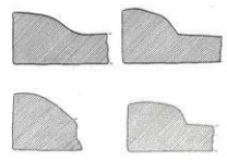
It is not possible here to thoroughly deal with achieved results, but some new approaches can be pointed out for the valorisation of archaeological evidence at territorial level. In a context of cultural contact among different cultures, objects may have played the role of culture spreading agents: from this idea of manufacture as a “cultural mediator”, our approach levels have proved to be particularly efficient and have supplied interesting thematic maps for the reconstruction of the ancient landscape. Those approach levels are also functional to the highlighting of exchange and contact dynamics among ancient populations. We are proposing two explanatory cases of study about the potential of the system. The colony-territory relation can be observed through the pottery spread and the correlated habits. In general, a tight bound between pottery distribution and solenes (Figure 4) can be observed in our territory .
Figure 4: Fragmentes of solenes
these solenes is made of a mixture which can be traced back to Himerian productions: from the colony, a system of covering spread not only to the closest sites, probably settled by colonists too, but also to the farthest settlements. The presence of larger living units, guaranteed by a stable terra cotta covering, makes us think of an increase of agriculture which must have led to stable presence of installations, growth of food production and the need to store it. The distribution of these construction materials can therefore document the spread of Greek covering systems in the indigenous world (Figure 5).
Figure 5: Distribution of the construction materials
To this phenomenon we can link the issue of handcraft transmission techniques and the presence of Greek craftsmanship in indigenous settlements, a topic we will deal with in the future. Another result this method has highlighted is the re-functionalising of pottery. We pointed out the processes of interchange between different forms and a change in the way food is prepared and consumed. Besides this, we have showed a new possible way to interpret – through this experimented methodology – the circulation
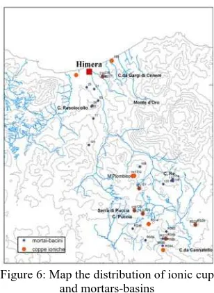
of a well documented manufacture in our territory, the basins and the achromatic mortars, by joining the data related to these materials with another category taken into examination, that of the ionic cup (Figure 6).
Figure 6: Map the distribution of ionic cup and mortars-basins
Figure7: Shaped loops with a little gorgonic mask impressed on them
As regards the second instead (Figure 8), beyond finding different products from Himera, the presence of this indicator can be interpreted in different ways. One interpretation could be the adoption of a typically Greek shape, the cup, (we must consider also the number of achromatic cups) into indigenous contexts replacing the indigenous traditional forms of painted pottery, like drinking cups and faired bowls (there is a poor presence of these two shapes in the whole territory); another one-and in this case it would be a re-functioning of the pot- it could affect those sites where such a shape is constantly associated with the above mentioned basins and mortars: some are situated in the river low valley, others instead belong to the far chora.
Figure 8: Ionic Cup
As for the latter, one could think of a privileged relationship with the colony expressed by these two manufactures which are peculiar of manufacturing, distribution and consume of specific cereal, as a result of Himera production surplus. In this case the Ionic drinking cup would assume the function of a pot used for distribution and measurement of a cereal ration, according to the eating habits of the Greek world, which are to be found also in the colonial context (Amoretti 1986; Lombardo 1999; Gallo 1984; Nenci 1999).
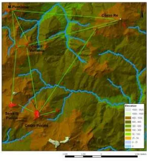
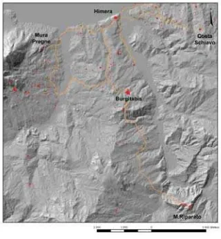
These examples show how the experimented information technology methodology applied to archaeological research may result into both a useful system for the understanding of the historical settlement dynamics and also to create records for the management and spread of the material culture in the territory. The research focuses on monitoring human activities in a particular territory in order to set models which are suitable for the comprehension of settlement dynamics and to widen knowledge as regards the features of settlement and resource exploitation. Therefore, this research might prove how the data about social and ideological aspects of ancient societies can be obtained not only from traditional classifying and descriptive study of archaeological excavations but also from a survey of settlements, locations and their relationships to intersite analysis of spatial finding distribution. In fact, it is clear that many of the sites sharing similar findings are linked in a spatial network which let us understand the real relationship that had to elapse between them. Analyzing geomorphological and environmental patterns of Imera and Torto valleys sites and comparing the settlements on the basis of the archaeological findings it was possible to note that they are also linked by a significant “inter-visibility” (Figure 9).
In addition, the Topographic Units have significant positions within roads reconstructed according to the analysis of the shortest path (Figure 10); it is also significant that this path, back through the GIS methodologies, on the basis of three-dimensional terrain models, is very similar to that of historic “Trazzere Regie”. This methodological approach will be, therefore, played for the main classes of pottery found during the archaeological survey. The data collected will be then examined in relation to the territory in order to reconstruct the ancient landscape, to determine the main types of indigenous and Greek settlement typologies of Imerese region and to establish which are the guide-fossil to improve the knowledge about customs, habits and movement of pottery within the chora of Himera.
Figure 10: Shortest path among the settlements in the Valley of Imera.
References
Amoretti, M. C., 1986. Le pain et l’huile
dans la Grèce antique, Paris.
Amyx, D., 1958. The Attic Stelai. Part III. Vases and other containers, in Hesperia XVII pp.163-610.
Bats, M., 1988.Vaseille et alimentation à Olbia de Provence (v. 350-v. 50 av. J. C.), in
RAN Suppl. 18, Paris.
Bats, M.-D’Agostino, B., 1999. Le vase céramique grec dans ses espaces: l’abitat, la tombe, in Céramique et peinture grecques, pp.75-90, Paris.
Belvedere, O. 2000. Osservazioni sulla cultura abitativa greca in età arcaica, in
Damarato, Milano, pp.58-68.
Bresson, A., 2007. Au-delà du primitivisme et du modernisme: Max Weber ou John Nash?, in Pallas 74, Toronto, pp. 17-30.
Burgio A., 2002, Resuttano (IGM 260 III SO), Forma Italiae 42, Firenze.
Cahill, N., 2002. Household and City
Organization at Olynthos, New
Haven-London 2002.
Cazzella, a., 1999. Terminologia e tipologia: denominare che cosa?, in Criteri di
nomenclatura, 13-20, Roma.
Gallo, L., 1984. Alimentazione e demografia
nella Grecia antica, Salerno.
Lombardo, M., 1999. Food and ‘Frontier’ in the Greek Colonies of South Italy, in Food
in Antiquity, Baltimore and London, pp.
256-272.
Millet, M., 2000. Dating, quantifying and utilizing pottery assemblages from surface survey, in Extracting meaning from
ploughsoil assemblages, Oxford, pp. 53-59.
Nenci, G., 1999. Il miglio e il panico nell’alimentazione delle popolazioni mediterranee, in Demografia, sistemi agrari, in Atti del Convegno Internazionale di Studi (Parma 17-19 ottobre 1997), Pragmateiai 3, Bari 1999, pp. 25-36.
Nevett, L.C., 2009. House and Society in the
Ancient Greek World, Cambridge.
Ruby, P., 1993. Types et fonctions dans les typologies ceramiques archeologiques. Quelques problemes et quelques propositions, in Annali dell’Istituto Orientale di Napoli XV, pp. 289-320.
Schreibler, T., 1999. Athenian Vase