INTRODUCTION
Drought is a natural hazard which has an impact on environmental, agricultural, social and economic sectors (Skakun, Kussul, N., Kussul, O., & Shelestov, 2014; Dalezios, Blanta, Spyropoulos, & Tarquis, 2014). In general, drought is classified into three types: meteorological, agricultural, and hydrological drought (Zargar, Sadiq, Naser, & Khan, 2011). Agricultural drought refers to impacts received by vegetation due to water and soil moisture deficit for agricultural use (Dalezios, Blanta, Spyropoulos, & Tarquis, 2014).
ENSO (El Niño-Southern Oscillation) is one the climate phenomena that affect rainfall variability in Indonesia. ENSO which annually dominates the variability of climate, is caused by the interaction of ocean and atmosphere. ENSO consists of
El Niño and La Niña. In El Niño conditions, the sea surface temperature in Eastern and Central Pacific Ocean are warmer than normal conditions, causing convective clouds and heavy rains in the region. Meanwhile, in Indonesian region is experiencing a decreasing of rainfall than normal. On the contrary to the conditions of La Niña, the sea surface temperature in Eastern and Central Pacific are cooler than normal conditions caused by the convection of clouds develops along Western Pacific and most part of Indonesia, which can lead to the increasing of rainfall in Indonesia (Holbrook et al., 2009). Based on the previous study, there was a clear relationship between ENSO phenomenon in decreasing/increasing of rainfall on the island of Java (Bey, Pramudia, June, & Amien, 2003). ENSO thus indirectly triggered the occurrence of agricultural drought in Indonesia.
Analysis of Agricultural Drought in East Java Using Vegetation Health Index
Luisa Febrina Amalo1), Rahmat Hidayat2*) and Sayidah Sulma3)1) Environmental Research Center (ERC), Bogor Agricultural University, Indonesia 2) Department of Geophysics and Meteorology, Bogor Agricultural University, Indonesia 3) National Institute of Aeronautics and Space, Indonesia
ARTICLE INFO
Drought indices are commonly used for drought assessment, particularly to identify the characteristics of drought i.e. duration, severity and areal extent (Khalil et al., 2013). Recently, satellites data are widely used for calculating the drought indices. Satellite data is an easy, quick, and inexpensive tools in monitoring drought in the regional scale compared to weather data observations (Domenikiotis, Spiliotopoulos, Tsiros, & Dalezios, 2004).
Drought index derived from remote sensing which popularly used is VHI (Vegetation Health Index). VHI is an index that represent the vegetation state then classified into different drought classes i.e. extreme, severe, moderate, mild, and no drought (Kogan, 2001). VHI has been used for drought mapping in many regions of the world (e.g. Kogan, 2001; Dalezios, Blanta, Spyropoulos, & Tarquis, 2014; Ghaleb, Mario, & Sandra, 2015; Khalil et al., 2013). For instance, the index has been used for estimating the crops productivity in Bangladesh (Rahman, Roytman, Krakauer, Nizamuddin, & Goldberg, 2009). Therefore, the index is considered to be more effective than other vegetation indices because VHI is a combination of other two drought indices, specifically TCI (Temperature Condition Index) and VCI (Vegetation Condition Index). These two indices are calculated using information of LST (Land Surface Temperature) and vegetation index EVI (Enhanced Vegetation Index). Both of these data sets are using MODIS imagery that have high temporal and spatial resolution for drought monitoring in regional scale. Besides, using MODIS data has proven to be good in monitoring agricultural drought in the previous studies (e.g. Wang, Lin, & Liu, 2014;
Khalil et al., 2013).
East Java is a province in Indonesia that has the largest agricultural land and agricultural production (Ministry of Agriculture, 2013). About 50 % of the total area of East Java is dominated by Agricultural area. Such condition makes East Java as one of the agricultural production centres in Indonesia. Drought hazard which occurs in East Java will certainly affect agricultural production regionally. Analysis of agricultural drought in East Java is expected to be used as an early warning of drought and mitigation measures to reduce the impact of drought on agricultural sustainability. The objectives of the research were (1) to identify the drought characteristics such as duration, severity, and areal extent, (2) to assess impacts of ENSO on agricultural drought of paddy fields and rice production in East Java using Vegetation Health Index.
MATERIALS AND METHODS Study Area
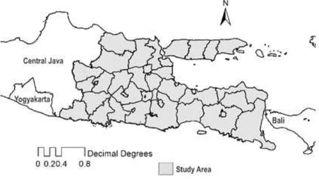
East Java is located at 7o16’S and 112o45’E (Fig. 1) and have an areal extent of 47,156 km2 which covers 29 districts and 9 cities (BPS – Statistics of Jawa Timur Province, 2015). East Java has a typical tropical climate, characterized by hot and humid weather. The rainfall pattern in the region is dominated by monsoonal rainfall pattern which has one peak of wet season and one peak of dry season. The wet season mostly occurs from November to May, while dry season occurs from June to October. The mean annual precipitation over East Java is about 1900 mm, and the temperature ranges between 21 oC to 34 oC.
East Java is one of the agricultural centre in Indonesia. The total area of agriculture is about 23,309 km2 which consists of paddy fields (irrigation and non-irrigation area), fields, plantations, forests, grasslands, unused area, and other lands. Agricultural land covers about 49.4 % of the total area of East Java Province compared to other provinces in Indonesia (BPS – Statistics of Jawa Timur Province, 2015).
Data Background
For estimating the VHI index, MODIS satellite data provided by the U.S. Geological Survey were used. Those data are Level 3 of MOD11C3 monthly LST and MOD13A3 monthly EVI with spatial resolution of 0.05o and 1 km, respectively from period of January 2001 to December 2015. Furthermore, CHRIPS (Climate Hazards Infrared Precipitation with Stations) data from IRI/LDEO Climate Data Library were also used to identify the influence of rainfall or other climate phenomena on drought (Funk et al., 2015). In addition, paddy fields map and rice production data were used to identify the impacts of agricultural drought on paddy fields and rice production. These data were obtained from National Institute of Aeronautics and Space (LAPAN) and Indonesian Statistics. This analysis defines that the sub-round 1 is from January to April, the sub-round 2 is from May to August, while the sub-round 3 is from September to October. Calculation of VHI
VHI is combined based on LST (temperature) and EVI (Vegetation Index) satellite data MODIS. EVI is determined by using MODIS red, blue, and NIR (Near Infrared) band reflectance (equation 1) (Rocha & Shaver, 2009). In vegetation optimum condition, chlorophylls absorb much visible light (380-700 nm) for photosynthesis processes. Therefore, reflectance of red light is reduced, and NIR reflectance increases. Low red reflectance indicates high EVI, while high EVI indicates healthy vegetation. Computation of vegetation index need to consider aerosols factor because they can scatter sunlight directly into the optical sensor and can increase the red visible light reflectance. Furthermore, aerosol can absorb sunlight and decrease NIR reflectance (Xiao et al., 2003).
Land Surface Temperature data are used to
describe the effect of thermal on vegetation health because high temperature and low humidity can cause plant stress. In this research, the data of LST and EVI were categorised as ready products obtained from MODIS, MOD11C3 for LST and MOD13A3 for EVI, and has been validated by NASA. The use of these products were under consideration of wide coverage of study area and long study period.
In VHI computation, LST and EVI need to be calculated into TCI and VCI. An equal weight combination between TCI and VCI will produce VHI which can be used as agricultural drought detection and monitoring (Dalezios, Blanta, Spyropoulos, & Tarquis, 2014). Moreover, TCI, VCI, and VHI were calculated by the following equations (2) (3) (4).
Where EVIi represents EVI of current month, EVImin and EVImax represent maximum and minimum EVI value throughout the time period. In this study, the time period refers to year of study which is from 2001 to 2015.
Where LSTi represents LST of current month, LSTmin and LSTmax represent maximum and minimum LST value in value throughout the time period.
Therefore, VHI can be calculated by applying the following equation:
TCI is an index which identified the stress condition of vegetation caused by high temperature and low moisture, while VCI are scaling the vegetation dynamic into ranges 0 to 100 showing the change of vegetation moisture from optimum condition to bad condition (Ghaleb, Mario, & Sandra, 2015). Coefficients of a and b in equation (4) are assumed to be equals 0.5 (Kogan, 2001). The reason putting 0.5 in each coefficient is because there is no clear ratio contribution between temperature and moisture in vegetation cycle. VHI which combined from TCI and VCI, presents a better drought identification knowledge about drought events, compare to single drought index indicator. VHI then classified into five classes proposed by Kogan (2001) for further analysis (see Table 1). (1)
(2)
(3)
This research covered the identification of agriculture drought characteristics, ENSO Impacts on Agricultural Drought in East Java, and Agricultural Drought on Paddy Fields and Rice Production. The analyses of agricultural impacts on rice production in the sub-round 1, 2, and 3 were done by compositing the monthly VHI into 4-months VHI to follow the cropping season in Indonesia, namely January-April (Sub-round 1), May-August (Sub-round 2), September-November (Sub-round 3).
RESULTS AND DISCUSSION
Identification of Agricultural Drought Character -istics
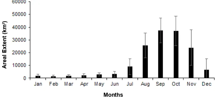
Drought characteristics are important factors to be identified for analysing drought monitoring. Drought characteristics are generally divided into three types: i.e. duration, severity, and areal extent (Zargar, Sadiq, Naser, & Khan, 2011). Drought duration is the interval of onset and end time drought which can be vary from months to years. While drought severity is an intensity of drought or the degree of climate variables deficit, i.e. extreme drought to mild drought. In addition, areal extent of drought is defined as a drought affected area that can cover several pixels or regions. Furthermore, the result of VHI converted from pixels in satellite data into km2 and presented in monthly VHI to analyse the drought characteristics.
Fig. 2 shows the onset and end time of drought in East Java. Agricultural drought usually starts from June, maximum in October, and ends in November. Agricultural drought in East Java mostly influenced by monsoonal phenomena from its areal extent pattern (Fig. 3). Indonesia is one of region where its rainfall is influenced by Asian Monsoon and Australian Monsoon. Asian and Australian Monsoon has led Indonesia to experience wet season (from December to February) and dry season (June to August) respectively. Meanwhile, March to May and September to November are categorized as transition seasons (Hermawan, 2010). According to Aldrian & Susanto (2003), Indonesian region which dominated by monsoonal precipitation pattern are South Sumatera, Central and South Kalimantan, Java, Bali, Nusa Tenggara, and most of Papua regions. East Java included within the area affected monsoonal phenomena. Previous study in India also stated that the drought in India generally occurs in Asian Monsoon season (June to September).
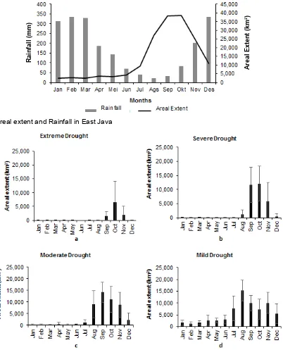
Rainfall amount in East Java reaches its minimum in August and maximum in February (Fig. 3). The pattern of rainfall in East Java is almost similar to the pattern of areal extent. When rainfall decreased (dry season), its areal extent increased significantly. On the contrary, when rainfall is gradually increased, the area of drought decreased significantly. During the wet season (December to February) and the transitional season (March to May) has experienced low drought. The coefficient of correlation between rainfall and areal extent is -0.59 which significant at 95 % confidence level based on linear regression. In addition, the coefficient of determination (R2 = 0.35) explained that about 35 % of variance of agricultural drought in East Java is affected by rainfall (Fig. 3). Table 1. Drought severity classes (Kogan, 2001)
VHI Drought Severity class
< 10 Extreme Drought < 20 Severe Drought < 30 Moderate Drought < 40 Mild Drought > 40 No Drought
Fig. 2. Cumulative areal extent VHI 0-40 (km2) monthly average for 15 years Months
Areal Extent (km
From Fig. 3, although the patterns of rainfall and areal extent seem similar, but there is a time lag between rainfall and areal extent. For example, the minimum rainfall occurs in August but the maximum of areal extent occurs in October (about 2 months’ lag). Chopra (2006) has been pointed that, the time lag between rainfalls with vegetation indices made rainfall patterns and areal extent shifted (not in the
same time interval). It caused by the time interval between rain starts falling and the time of raindrops arrived in soil and began to affect plant growth. Therefore, when drought occurs (deficit of rainfall), the soil still holds enough water to plants and not directly affected by drought. The time interval is approximately 1-3 months depending on the plant types.
Fig. 3. Areal extent and Rainfall in East Java
Fig. 4. Areal extent based on drought severity classes in East Java 2001-2015
Rainfall (mm)
Areal Extent (km
Analysis of areal extent based on Kogan (2001) severity classes show extreme drought usually starts in September, reach its maximum in October and ends in November (Fig. 4a) Severe drought starts in August, maximum in October and ends in November (Fig. 4b), while moderate drought starts in June, maximum in September and ends in October (Fig. 4c), and mild drought starts in June, maximum in August and ends in September (Fig. 4d). Generally, the duration and areal extent of extreme drought are much shorter and smaller than else classes. Mild drought occurs almost throughout the year but the areal extent is relatively small. Mostly, the higher the drought severity, the shorter the drought duration would be as drought happened to develops slowly (Khalil et al., 2013). ENSO Impacts on Agricultural Drought in East Java
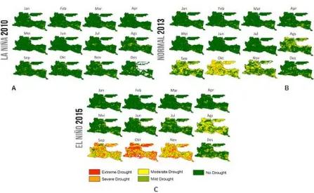
This analysis is expected to show the condition of agricultural drought in East Java during ENSO apart from the influence of the monsoon phenomenon which occurs almost every year. La
Niña year 2010 (La Niña Moderate), El Niño year 2015 (El Niño strong), and normal year 2013 were selected to represent ENSO years (CPC, 2015).
The difference of agricultural drought between La Niña (2010), normal (2013), and El Niño (2015) can be seen from its duration, severity, and areal extent (Fig. 5 and Fig. 6). In La Niña (2010), drought has less impact and not significantly occurred throughout the year. In normal condition (2013), drought occurs in August to November (± 4 months). Meanwhile, in El Niño (2015), drought onset occurs in August to December (± 5 months). Besides, Agricultural drought in El Niño (2015) has higher severity than two other years. Areal extent in La Niña (2010) tends to has low areal extent throughout the year about ± 197,343 km2, then normal condition (2013) about 115,443 km2 and El Niño (2015) about ± 28,685 km2. Those areal extent values refer to one-year cumulative areal extent. Drought severity in El Niño (2015) and normal condition (2013) is vary from mild to extreme drought (VHI 0-40), while La Niña (2010) is only mild to severe drought (VHI 10-40).
Agricultural Drought on Paddy Fields and Rice Production
East Java is one of the agricultural production centres in Indonesia. Agricultural area in East Java reached 49.4 % of the total area of East Java. In addition, East Java is also rice production centre with largest areal of paddy fields and rice production among other provinces in Indonesia. Therefore, the analyses of agricultural drought limited to paddy fields to see the impact of agricultural drought on rice production in East Java. This study is not analysing other crops besides rice because of limited data and map specific cropland. Rice commodity is vulnerable to drought because rice has high water needs (Irawan, 2006). Rice plants and other crops e.g. corns, peanuts, green beans, planted on three cropping seasons in Indonesia, namely Sub-round 1 (January to April), Sub-round 2 (May-August), and Sub-round 3 (September-December).
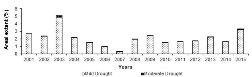
In the Sub-round 1 (Fig. 7), Paddy fields generally did not experience drought from 2001 to
2015. The drought classes in the Sub-round 1 only has mild and moderate drought class because severe and extreme drought did not occur throughout the year of study. The non-affected drought area of paddy fields in the sub-round 1 reaches > 95 % of the total paddy fields area. The wide-effected drought in paddy fields occurred in 2003, about 5 % area of the paddy fields. The year matches with El Niño year 2003 (moderate intensity) which index was rising in January to March (CPC, 2015). Low drought affected area of paddy fields occurred in 2007 with areal extent reached only 0.34 % due to La Niña events that happened that year (CPC, 2015). Therefore, the Sub-round 1 is the most effective growing season to maximize rice production observed during 15 years, because the drought affected area were relatively low. Low affected area can be caused by wet season which occurs in the same time with planting time in the sub-round 1. In a previous analysis (Fig. 2) has also explained that the average drought area (km2) from January through April in East Java during 15 years is relatively low. Fig. 6. Areal extent (km2) in La Nina 2010, Normal 2013, and El Nino 2015 years based on VHI index (0 ≤ VHI ≤ 40)
Fig. 7. Areal extent classification in paddy fields on Subround 1 (January-April)
Areal extent (%)
Meanwhile, in the sub-round 2 (May-August), areal extent increased 20 % than the sub-round 1 (Fig. 7 and Fig. 8). Severity in the sub-round 2 were mild to moderate drought. Severe and extreme drought were very low < 10 km2 (~0 %) therefore it was not presented in graphic below. Agricultural drought most effected in 2002-2003, 2009, and 2015 with areal extent more than 20 % of paddy fields total area. Those four years were El Niño years (CPC, 2015). While, low drought affected area was found in 2007 and 2010 which the occurrence years of La Niña (CPC, 2015).
The sub-round 3 was the most drought affected season among the sub-rounds. September
to December are the peak of dry season and from previous analysis, agricultural drought maximum in October (Fig. 3). In the sub-round 3, the drought severity started from mild to extreme drought yearly, except in 2001 and 2010 (areal extent < 25 %) (Fig. 9). In 2015, although El Niño with strong intensity occurred, the area affected by drought was not as wide as 2006 which occurred only El Niño with weak intensity. The climate variability which occurred in 2006 speculated not only El Niño but also IOD phenomenon (Indian Ocean Dipole) positive, therefore, Indonesia had experienced greater rainfall deficit than in 2015 (Fadholi, 2013).
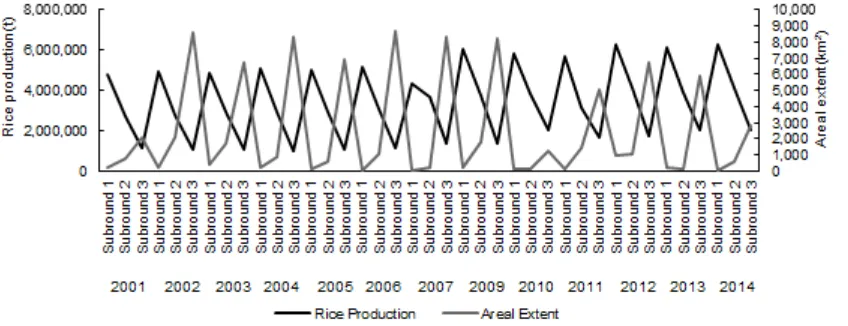
Fig. 10. The relationship between areal extent and rice production in Subround 1, 2, dan 3 during 2001-2014 Fig. 9. Areal extent classification in paddy fields on Subround 3 (September-December)
Fig. 8. Areal extent classification in paddy fields on Subround 2 (May-August)
Areal extent (%)
The results showed that the sub-round 1 is the lowest affected area by drought among others, followed by the sub-round 2 and sub-round 3 (Fig. 10). The highest rice production also mostly occurred in the sub-round 1, then the sub-round 2, and the lowest rice production occurred in the sub-round 3. Based on the results, agricultural drought indeed influenced the rice production in East Java. The coefficient of correlation and determination between areal extent and rice production relatively high (r = -0.79 and R2 = 0.64) based on linear regression. The negative correlation means if the areal extent of drought increases, the high possibility of rice production decreases. The coefficient of determination means about 64 % factors of areal extent can be explained the decreasing/increasing rice production in East Java.
The relationships between agricultural drought and rice production in this analysis is limited to general discussion. It means that the results of this analysis can only explain the low of rice production in the sub-round 3 and higher of rice production in the sub-round 1 generally. Areal extent in paddy fields in the sub-round 3 is generally higher than other Sub-rounds, therefore farmers tend to plant other crops which more resistant to drought such as nuts and tubers (Irawan, 2006) in the sub-round 3. Farmers are more at risk to plant rice in the sub-round 3 because of the possibility of crop failure (Puso) is high. It caused the production of rice in the sub-round 3 is the lowest each year.
Meanwhile, despite drought is affecting rice production, the trend of rice production in East Java tends to increase from year to year even the climate anomalies such as ENSO and other climate phenomena occurred. It can be caused by the increasing in technology such as fertilizer or technology for processing the paddy fields are getting better from year to year. In addition, because East Java is the centre area of rice production, the government’s attention to paddy fields and rice production is higher.
CONCLUSION AND SUGGESTION
Agricultural Drought in East Java usually occurs in June, reach its maximum in October, and ends in November. The onset and end time mostly follow the monsoonal rainfall pattern, therefore the Agricultural Drought in East Java is influenced
by Monsoon Phenomena. Furthermore, ENSO had impact on agricultural drought in East Java, longest drough duration, areal exttent and severity in El Niño year (± 5 months, ± 197,343 km2, mild-extreme drought (VHI 0-40)) than normal in 2013 (± 4 months, ± 115,443 km2, mild-extreme drought (VHI 0-40)) and La Niña in 2010 (not significantly occurred, ± 28,685 km2, mild-severe drought (VHI 10-40)). The results of analysis of agricultural drought in paddy fields and rice production in East Java showed that the most affected area by drought in paddy fields was in Sub-round 3 (September-December), followed by Sub-round 2 (May-August), while Sub-round 1 (January-April) had low impact of drought. Meanwhile, the rice production mostly has the lowest in Sub-round 3, then Sub-round 2, and highest was in Sub-round 1. This indicates that drought affecting rice production differently in each Sub-round. Results showed a good correlation between Agricultural Drought and Rice production (r = -0.79) which significant in the level of 99 %. The overall results and analyses implied that in the future, the information of the occurrence of drought and other climate anomalies should be informed to crops farmers as early warning or mitigation. Lack of those information can lead to crop failures and affecting the food security.
ACKNOWLEDGEMENT
The authors gratefully acknowledge the U.S. Geological Survey (USGS), IRI/LDEO Climate Data Library, and Statistics Indonesia for providing MODIS archive, monthly rainfall CHIRPS, and rice production data used in this research.
REFERENCES
Aldrian, E., & Susanto, R. D. (2003). Identification of three
dominant rainfall regions within Indonesia and their relationship to sea surface temperature.
International Journal of Climatology, 23(12), 143
5–1452. http://doi.org/10.1002/joc.950
Bey, A., Pramudia, A., June, T., & Amien, L. I. (2003).
BPS – Statistics of Jawa Timur Province. (2015). Jawa Timur dalam angka 2015 [Jawa Timur in figures
2015]. Surabaya, ID: CV. Media Konstruksi. Retrieved from http://jatim.bps.go.id/4dm!n/pdf_ publikasi/Jawa-Timur-Dalam-Angka-2015.pdf
Chopra, P. (2006). Drought risk assessment using remote sensing and GIS: A case study of Gujarat
(Master Thesis). Retrieved from ITC Library, The Netherlands (https://www.itc.nl/library/paper_20 06/msc/iirs/chopra.pdf)
CPC. (2015). Cold & warm episodes by season. National Weather Service, National Oceanic and Atmospheric Administration. Retrieved from http://origin.cpc.ncep.noaa.gov/products/ analysis_monitoring/ensostuff/ONI_v5.php
Dalezios, N. R., Blanta, A., Spyropoulos, N. V., & Tarquis,
A. M. (2014). Risk identification of agricultural
drought for sustainable agroecosystems. Natural Hazards and Earth System Sciences, 14(9),
2435–2448. http://doi.org/10.5194/nhess-14-24
35-2014
Domenikiotis, C., Spiliotopoulos, M., Tsiros, E., & Dalezios, N. R. (2004). Early cotton yield assessment by the use of the NOAA/AVHRR derived Vegetation Condition Index (VCI) in Greece. International Journal of Remote Sensing, 25(14), 2807-2819. http://doi.org/10.1080/01431160310001632729
Fadholi, A. (2013). Studi dampak El Nino dan Indian Ocean Dipole (IOD) terhadap curah hujan di Pangkalpinang [Study the impact of El Nino and Indian Ocean Dipole (IOD) on rainfall in Pangkalpinang]. Jurnal Ilmu Lingkungan, 11(1), 43-50. http://doi.org/10.14710/jil.11.1.43-50
Funk, C., Peterson, P., Landsfeld, M., Pedreros, D., Verdin, J., Shukla, S., … Michaelsen, J. (2015). The climate hazards infrared precipitation with stations—a new environmental record for monitoring extremes. Scientific Data, 2, 150066. http://doi.org/10.1038/sdata.2015.66
Ghaleb, F., Mario, M., & Sandra, A. (2015). Regional landsat-based drought monitoring from 1982 to 2014. Climate, 3(3), 563–577. http://doi.org/10.3
390/cli3030563
Hermawan, E. (2010). Pengelompokkan pola curah hujan yang terjadi di beberapa kawasan P. Sumatera berbasis hasil analisis teknik spektral [Grouping of rainfall pattern that happened in some region of Sumatra Island based on spectral technique
analysis result]. Jurnal Meteorologi dan
Geofisika, 11(2), 75-85. Retrieved from http://
puslitbang.bmkg.go.id/jmg/index.php/JMG/ article/viewFile/67/61
Holbrook, N. J., Davidson, J., Feng, M., Hobday, A. J., Lough, J. M., McGregor, S., & Risbey, J. S.
(2009). El Niño – Southern Oscillation. In E. S.
Poloczanska, A. J. Hobday & A. J. Richardson (Eds.), Report card of marine climate change for Australia 2009. Southport, AU: NCCARF. Retrieved from http://www.wamsi.org.au/sites/
wamsi.org.au/files/Project%202.2%20El%20 Ni%C3%B1o%20Southern%20Oscillation.pdf
Irawan, B. (2006). Fenomena anomali iklim El Nino dan La Nina: Kecenderungan jangka panjang dan pengaruhnya terhadap produksi pangan [The phenomenon of El Nino and La Nina climate anomalies: Long-term trends and their effects on food production]. Forum Penelitian Agro Ekonomi, 24(1), 28-5. http://doi.org/10.21082/fa e.v24n1.2006.28-45
Khalil, A. A., Abdel-Wahab, M. M., Hassanein, M. K., Ouldbdey, B., Katlan, B., & Essa, Y. H. (2013). Drought monitoring over Egypt by using MODIS land surface temperature and normalized difference vegetation index. Nature and Science, 11(11), 116-122. Retrieved from http://www.sciencepub.net/ nature/ns1111/017_20924bns11 11_116_122.pdf
Kogan, F. N. (2001). Operational space technology for global vegetation assessment. Bulletin of the American Meteorological Society, 82(9), 1949–1964. http://
doi.org/10.1175/1520-0477(2001)082
Ministry of Agriculture. (2013). Statistik makro sektor pertanian 2013 [Macro statistics for agricultural sector 2013]. Jakarta, ID: Pusat Data dan Sistem Informasi Pertanian, Kementerian Pertanian. Retrieved from http://pusdatin.setjen.pertanian. go.id/tinymcpuk/gambar/file/Buku_Statistik_ Makro_2013.pdf
Rahman, A., Roytman, L., Krakauer, N. Y., Nizamuddin, M., & Goldberg, M. (2009). Use of vegetation health data for estimation of aus rice yield in Bangladesh. Sensors, 9(4), 2968–2975. http://
doi.org/10.3390/s90402968
Rocha, A. V., & Shaver, G. R. (2009). Advantages of a two band EVI calculated from solar and photosynthetically
active radiation fluxes. Agricultural and Forest Meteorology, 149(9), 1560–1563. http://doi.
Skakun, S., Kussul, N., Kussul, O., & Shelestov, A. (2014). Quantitative estimation of drought risk in Ukraine using satellite data. Paper presented at Geoscience and Remote Sensing Symposium (IGARSS), 2014 IEEE International, Quebec City, Canada, 13-18 July. Quebec City, CA: IEEE. Retrieved from http://ieeexplore.ieee.org/ document/6947642/
Wang, H., Lin, H., & Liu, D. (2014). Remotely sensed drought Index and its responses to meteorological drought in Southwest China. Remote Sensing Letters, 5(5), 413–422. http://doi.org/10.1080/21 50704X.2014.912768
Xiao, X., Braswell, B., Zhang, Q., Boles, S., Frolking, S.,
& Moore, B. (2003). Sensitivity of vegetation indices to atmospheric aerosols: Continental-scale observations in Northern Asia. Remote Sensing of Environment, 84(3), 385–392. http:// doi.org/10.1016/S0034-4257(02)00129-3
Zargar, A., Sadiq, R., Naser, B., & Khan, F. I. (2011). A review of drought indices. Environmental Reviews, 19,