i
DEVELOPING A LOCAL INSTRUCTION THEORY ON
THE CARTESIAN COORDINATE SYSTEM
A THESIS
Submitted in Partial Fulfillment of the Requirement for the Degree of Master of Science (M. Sc)
in
International Master Program on Mathematics Education (IMPoME) Faculty of Teacher Training and Education, Sriwijaya University (In Collaboration between Sriwijaya University and Utrecht University)
By:
LAURADO RINDIRA SABATINI NIM 06022681318072
FACULTY OF TEACHER TRAINING AND EDUCATION SRIWIJAYA UNIVERSITY
ii
APPROVAL PAGE
Research Title : Developing a Local Instruction Theory on the Cartesian Coordinate System
Student Name : Laurado Rindira Sabatini
Student Number : 06022681318072
Study Program : Mathematics Education
Approved by:
Prof. Dr. Ratu Ilma Indra Putri, M.Si. Dr. Yusuf Hartono
Supervisor I Supervisor II
Dean of Faculty of Teacher Training Head of Mathematics Education
and Education Department
Prof. Sofendi, M.A., Ph.D. Prof. Dr. Ratu Ilma Indra Putri, M.Si. NIP 19600907 198703 1 002 NIP 19690814 199302 2 001
iii
DEVELOPING A LOCAL INSTRUCTION THEORY ON
THE CARTESIAN COORDINATE SYSTEM
A THESIS
Submitted in Partial Fulfillment of the Requirement for the Degree of Master of Science (M. Sc)
in
International Master Program on Mathematics Education (IMPoME) Faculty of Teacher Training and Education, Sriwijaya University (In Collaboration between Sriwijaya University and Utrecht University)
By:
Laurado Rindira Sabatini NIM 06022681318072
Approved by Examination Committee Signature
Prof. Dr. Ratu Ilma Indra Putri, M.Si. _________________
Sriwijaya University
Dr. Yusuf Hartono _________________
Sriwijaya University
Prof. Dr. Zulkardi, M.I.Komp., M.Sc. _________________
Sriwijaya University
Dr. Darmawijoyo, M.Sc., M.Si. _________________
Sriwijaya University
Dr. Somakim, M.Pd. _________________
Sriwijaya University
FACULTY OF TEACHER TRAINING AND EDUCATION SRIWIJAYA UNIVERSITY
iv I hereby:
Name : Laurado Rindira Sabatini Place of Birth : Surabaya
Date of Birth : February 23, 1990 Academic Major : Mathematics Education
State that:
1 All the data, information, analyses, and the statements in analyses and conclusions that presented in this thesis, except from reference sources are the results of my observations, researches, analyses, and views with the guidance of my supervisors.
2 The thesis that I had made is original of my mind and has never been presented and proposed to get any other degree from Sriwijaya University or other Universities.
This statement was truly made and if in other time that found any fouls in my statement above, I am ready to get any academic sanctions such as, cancelation of my degree that I have got through this thesis.
Palembang, July 2015 The one with the statement
v ABSTRACT
This study is aimed at contributing the development of a local instructional theory that can foster students’ understanding of the positive quadrant of the Cartesian coordinate system. To achieve the intended aim, design research is chosen as a study approach by performing an iterative process of designing instructional activities, conducting teaching experiments, and accomplishing retrospective analysis. In this study, the instructional activities are designed based on realistic mathematics education (RME) theory and a hypothetical learning trajectory (HLT) is developed to know how the fifth graders’ (aged 10 – 11 years old) learn and understand the Cartesian coordinate system. Data collection were conducted through recording the classroom activity or group works, colleting the students’ written work and making field notes. The developed HLT was then compared to students’ actual learning trajectory to investigate whether the designed-instructional sequence support students’ understanding of the Cartesian coordinate or not. The retrospective analysis of the teaching experiments confirms that the students were able to make an alphanumeric grid system as the primary activity before learning the Cartesian coordinate. In addition, they were also able to make a system looked like the positive quadrant of the Cartesian coordinate by investigating the horizontal and the vertical distance as embedded in the taxicab distance. Their understanding about both distances, in further, helped them to use an ordered pair to locate and plot any points on the positive quadrant of the Cartesian plane.
vi
vii SUMMARY
Cartesian coordinate system plays a fundamental role to the skills related map reading, reading graph as well as making graph (Somerville & Bryant, 1985; Blades & Spencer, 2001). Signifying that importance, however, the Cartesian coordinate system is commonly introduced as a ready-made system that leads to a
lack of students’ understanding because they are merely asked to remember the rule and the notation (Palupi, 2013; Kemendikbud, 2014). For this reason, a set of instructional activities are needed to have students encounter, reinvent and understand the mathematical ideas behind the Cartesian coordinate by themselves.
This study is aimed at contributing the development of local instructional theory on the Cartesian coordinate focused on the positive quadrant in fifth grades. To achieve the intended aim, we develop innovative educational materials based on realistic mathematics education (RME) approach by and iteratively conduct adjustment on it. It implies that we need both the design of instructional materials and the research on how these materials support students understanding the concept. Therefore, this study employs design research as the research approach.
Within the main two cycles of design research, namely micro and macro cycle, the hypothetical learning trajectory (HLT) plays an important role. We designed the HLT consisting of four main components: students’ starting points, learning goals,
learning activities, and the conjecture of students’ thinking. This HLT was then
implemented to thirty students of the fifth grade (i.e Pusri Primary School, Palembang) within pilot teaching experiment and teaching experiment.
viii
Sistem koordinat Cartesius memiliki peranan yang sangat penting terhadap keahlian yang berhubungan dengan membaca peta ataupun grafik serta membuat grafik (Somerville & Bryant, 1985; Blades & Spencer, 2001). Menyoroti pentingnya materi tersebut, sistem koordinat ini biasanya diperkenalkan sebagai sistem yang siap pakai kepada siswa sehingga berujung kepada kurangnya pemahaman siswa terhadap materi tersebut (Palupi, 2013; Kemendikbud, 2014). Menanggapi hal tersebut, seperangkat aktivitas pembelajaran sangat dibutuhkan untuk mengajak siswa menemukan kembali serta memahami konsep matematika dibalik materi sistem koordinat Cartesius.
Penelitian ini bertujuan untuk mengembangkan teori pembelajaran lokal mengenai sistem koordinat Cartesius yang difokuskan pada kuadran pertama. Untuk mencapai tujuan tersebut, seperangkat materi pembelajaran yang inovatif dikembangkan berdasarkan prinsip pendidikan matematika realistik (RME) dengan melakukan penyesuain secara iteratif. Hal ini menyiratkan bahwa dibutuhkan dua hal penting, yakni desain materi pembelajaran serta penelitian tentang bagaimana materi tersebut membantu siswa untuk memahami sistem koordinat Cartesius.
Dugaan lintasan belajar (HLT) memiliki peranan yang sangat penting dalam dua siklus utama dari design research, yakni siklus mikro dan makro. Dugaan lintasan belajar (HLT) tersebut didesain dengan menenkankan empat komponen utama, yakni pengetahuan awal siswa, tujuan pembelajaran, aktivitas pembelajaran, serta dugaan cara berpikir siswa. HLT tersebut kemudian diimplementasikan kepada 30 orang siswa kelas V (SD Pusri Palembang) dalam dua tahapan, yakni pembelajaran pada kelompok kecil serta pembelajaran di kelas besar.
ix
x know when you find it.”
Steve Jobs
“Education is not the learning of fact, but the training of the mind to think”
Albert Einstein
For Sudjanarko and Suwaning Supriyatin
xi PREFACE
This thesis would not exist without the help of many excellent people. First thanks go to Frans van Galen , my supervisor, for providing me with many suggestions and advices for the most crucial parts of this thesis. My thanks are also given to all staffs and lecturers in the Freudenthal Institute for Science and Mathematics Education (FIsme), Utrecht University, including Maarten Dolk, Dolly van Eerde, and Mark Uwland for their helpful comments and suggestions. My thanks also go to my supervisors in the Mathematics Education Department, Sriwijaya University, Prof. Dr. Ratu Ilma Indra Putri, M.Si and Dr. Yusuf Hartono for their insightful discussion and support in finishing this thesis.
I would like to acknowledge the following parties for their involvements throughout this study.
Prof. Dr. Ir. Anis Saggaff, M.ScE., Rector Sriwijaya University
Prof. Sofendi, M.A., Ph.D., Dean of Faculty of Teacher Training and Education, Sriwijaya University
Directorate General of Higher Education (Dikti) Nuffic – NESO Indonesia
Prof. R.K. Sembiring, IP-PMRI
All lecturers in Mathematics Education Department in Sriwijaya University IMPoME students either in Palembang and Surabaya
SD Pusri Palembang
I also thanks to my lovely siblings Dedit Sugianto, Christina Rita S., Rini Sulistryowati and Rionardo Daffncy S. for giving me motivations to completing this thesis. I am fully aware that I cannot mention all parties that have impacts to this study one by one, but for their kindness, I say thank you.
xii
CHAPTER II THEORETICAL BACKGROUND ... 4
2. 1. Cartesian coordinate system ... 4
2. 2. The Importance of the Coordinate System ... 6
2. 3. Students’ Difficulty in Understanding the Coordinate System ... 7
2. 4. Realistic Mathematics Education ... 8
2. 4. 1. Five Tenets of Realistic Mathematics Education ... 9
2. 4. 2. Guided Reinvention ... 11
2. 5. The Role of the Teacher ... 15
2. 6. Social Norms ... 15
2. 7. Socio-mathematical Norms ... 16
2. 8. The Coordinate System in the Indonesian Curriculum ... 17
2. 9. Research Aims and Research Questions ... 18
CHAPTER III METHODOLOGY ... 19
3. 1 Research Approach ... 19
3. 1. 1 Preparation and Design Phase ... 19
3. 1. 2 Teaching Experiment Phase ... 20
3. 1. 3 Retrospective Analysis Phase ... 21
3. 2 Data Collection ... 21
3. 2. 1 Preparation and Design Phase ... 21
3. 2. 2 Preliminary Teaching Experiment (cycle 1) ... 22
3. 2. 3 Teaching Experiment (cycle 2) ... 23
3. 2. 4 Pretest and Posttest... 23
3. 2. 5 Validity and Reliability ... 24
3. 3 Data Analysis ... 25
3. 3. 1 Pretest ... 25
3. 3. 2 Preliminary-Teaching (cycle 1) ... 25
3. 3. 3 Teaching Experiment (cycle 2) ... 26
3. 3. 4 Posttest ... 26
3. 4 Validity and Reliability ... 26
xiii
3. 4. 2 External and Ecological validity ... 27
3. 4. 3 Internal reliability ... 27
3. 4. 4 External reliability... 27
3. 5 Research Subject ... 27
3. 6 Timeline of the Research... 28
CHAPTER IV HYPOTHETICAL LEARNING TRAJECTORY ... 29
4. 1 Labeling Blocks of City Blocks ... 30
4. 2 Chess Notation ... 34
4. 3 Taxicab Routes and Distance ... 36
4. 4 How to Use an Ordered Pair ... 44
4. 5 Sunken Ship... 49
4. 6 Cartesian coordinate system (Positive Quadrant) ... 53
CHAPTER V RETROSPECTIVE ANALYSIS ... 59
5. 1. Retrospective Analysis of the Preliminary Teaching (First Cycle).... 59
5. 1. 1 Pretest ... 59
5. 2. Overview of Classroom Condition ... 80
5. 3. Overview of the Teacher ... 81
5. 4. Teaching Experiment (second cycle) ... 81
5. 4. 1 Pre-Test ... 82
5. 4. 7 Activity 6: Cartesian Coordinate (Positive Quadrant) ... 101
5. 4. 8 Post-Test... 104
5. 4. 9 Conclusion of the teaching experiment (cycle 2) ... 110
CHAPTER VI CONCLUSION AND SUGGESTION ... 111
xiv
xv
LIST OF FIGURES
Figure 2. 1 The Cartesian coordinate with four quadrants numbered I, II, III, and IV .5
Figure 2. 2 Alphanumeric Grid System Showing C3 ...12
Figure 2. 3 The example of taxicab routes from point A to B ...13
Figure 4. 1 Photograph (left) and Street Map (right) of City Blocks ………….……31
Figure 4. 2 The Street Map of Jakabaring Blocks City ...32
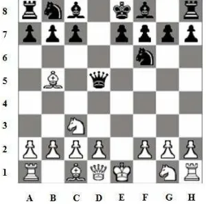
Figure 4. 3 The System for the Conventional Chess Notation. ...35
Figure 4. 4 The Alphanumeric Grid System in the City Blocks ...38
Figure 4. 5 The Street Map of Jakabaring CIty Blocks ...38
Figure 4. 6 The Street Map of Jakabaring City Blocks ...40
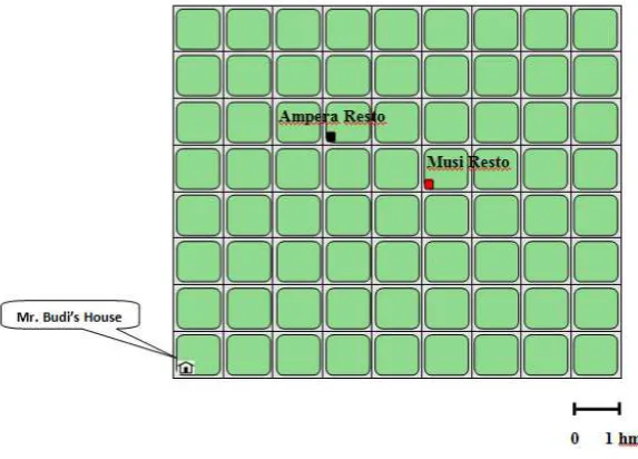
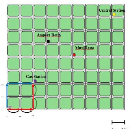
Figure 4. 7 The Shortest Path with One Turn from the House to Ampera Resto ...41
Figure 4. 8 The Shortest Path with One Turn from the House to Musi Resto ...42
Figure 4. 9 The Street Map of Jakabaring City Blocks ...43
Figure 4. 10 A System for Determining the Taxicab Distance ...43
Figure 4. 11 System for Locating Objects in the City Blocks ...45
Figure 4. 12 The Danger Zone in Figure A (left) and in Figure B (right) ...47
Figure 4. 13 The Street Map of Jakabaring City Blocks ...49
Figure 4. 14 The Sea Map ...50
Figure 4. 15 The First Quadrant of the Cartesian System in the Sea Map ...51
Figure 4. 16 The First Alternative Drawing ...55
Figure 4. 17 The Second Alternatives Drawing. ...55
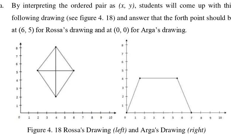
Figure 4. 18 Rossa's Drawing (left) and Arga's Drawing (right) ...57
Figure 4. 19 Figure 4. 18 Rossa's Drawing (left) and Arga's Drawing (right) ...57
Figure 5.1 Darren's (left) and Salsabila's (right) answer of first item of pre-test …...60
Figure 5.2 Darren's (left)and Basith’s (right) answer of the second item of pre-test .61 Figure 5.3 Calculating (PQ) ̅ using the strategy of counting one by one ...61
Figure 5.4 Darren's and Salsabila’s answer of the fourth item of the pre-test ...62
Figure 5.5 Darren's answer (left)and Siti’s answer (right) of the fifth problem ...62
Figure 5.6 Salsabila's (left) and Basith’s (right) answer of the fifth item of pre-test ..63
Figure 5.7First task of making s system for labeling city blocks Jakabaring ...63
Figure 5.8The Written Work of the First Group (left) and the Second Group (right) ...64
Figure 5.9Groups' written works on locating pawns using the chess notation ...65
Figure 5.10 Students' written work of locating objects on the city blocks precisely ...67
Figure 5.11Second group's written work of making three taxicab routes and conclusion about the distance covered by those routes...68
Figure 5.12The written work on determining a system for taxicab distance in city blocks ...68
Figure 5.13Second group's work on locating object using a system involving the distance ...70
xvi
Figure 5.17Second groups' work on locating the rescue teams using ordered pairs ..73 Figure 5.18First (right) and second group’s (left)written work on “guess the
shape” ...74 Figure 5.19First group’s (right) and second group’s (left)work on “guess the
shape” ...75 Figure 5.20 The students’ work on locating the seat in the first item of post-test ...76 Figure 5.21 The students’ work on locating pawns in the second item of post-test ....77 Figure 5.22 The students’ work on locating the ship in the third item of post-test ...78 Figure 5.23 Students’ work on plotting ordered pairs in the fourth item of post-test .78 Figure 5.24 Locating and plotting points in the fifth item of post-test ...79 Figure 5.25 The students’ work on locating Budi’s seat in the first item of pre-test ..82 Figure 5.26 The students’ work on locating pawns in the second item of pre-test ...83 Figure 5.27 The students’ work on locating the ship in the fourth item of pre-test ....84 Figure 5.28 The students’ work on locating point D in the fifth item of pre-test ...85 Figure 5.29 The task for labeling blocks in Jakabaring City Blocks ...86 Figure 5.30The groups work on making the alphanumeric grid system for labeling
blocks ...86 Figure 5.31The written works of group 7 (left) and group 2 (right) ...87 Figure 5.32The groups’ written works on locating pawns using the chess notation
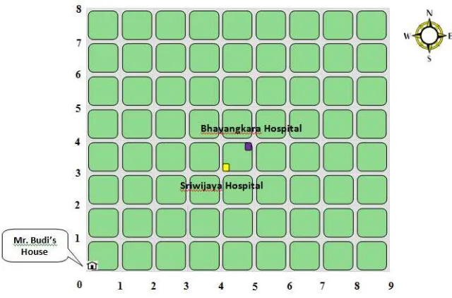
system ...89 Figure 5.33The groups’ works on locating Bhayangkara hospital in the city blocks .91 Figure 5.34Three taxicab routes from Mr. Budi’s house to Bhayangkara hospital ....91 Figure 5.35The groups’ conclusion about the distance covered by three different
routes ...92 Figure 5.36The student’s work on determining the horizontal and the vertical
distance ...93 Figure 5.37The student’s work on making a system looked like the positive
quadrant...94 Figure 5.38The written work on locating objects using the horizontal & vertical
distance ...95 Figure 5.39The student plotted an object on the street map of the city blocks ...96 Figure 5.40The example of written work on plotting the coordinates on the street
map ...96 Figure 5.41The example of written work on locating the sunken ship on the sea
map ...98 Figure 5.42The task of locating SAR teams on the sea map from the lighthouse ...98 Figure 5.43The task of locating SAR team on the sea map from the lighthouse ...99 Figure 5.44The examples of students’ written work on locating SAR team A, B,
and C ...100 Figure 5.45The students’ conclusion related to the activity of locating ships on a
xvii
Figure 5.46The students’ work on plotting points A, B, C, D in secret
quadrilateral task ...102 Figure 5.47The students’ work on plotting points K, L, M in secret coordinate
task ...104 Figure 5.48The students’ answer on locating the seat in the first item of post-test..105 Figure 5.49The students’ answer of locating Black Queen and White King ...106 Figure 5.50Two answers of locating pawns using the Cartesian coordinate ...106 Figure 5.51Locating pawns using a system looked like the Cartesian coordinate ...106 Figure 5.52The students’ answer of locating the sunken ship from the lighthouse .107 Figure 5.53The students’ answer of locating the SAR team from the lighthouse ....108 Figure 5.54The students’ answer of locating the lighthouse (as the origin) ...108 Figure 5.55The students’ answer of plotting A, B, C and determining point D ...109 Figure 5.56The students’ answer of plotting A, B, C and specifying the coordinate
xviii
Appendix A. Teacher Interview Scheme ... 117
Appendix B. Classroom Observation Scheme ... 118
Appendix C. Pre-test ... 119
Appendix D. Post-test ... 121
Appendix E. Student Worksheet... 123
Appendix F. Teacher Guide ... 136
Appendix G. Decree of Supervisors Establishment (Surat Keputusan Penetapan Dosen Pembimbing) ... 159
Appendix H. Research License (Surat Izin Penelitian) ... 160
Appendix I. Certificate of Conducting Research (Surat Keterangan Telah Melaksanakan Penelitian) ... 161
Appendix J. Evidence Letter of Revising Thesis (Bukti Telah Memperbaiki Tesis)... 162
Appendix K. Notulen of Thesis Defense ... 163
Appendix L. Letter of Consent ... 164
1
CHAPTER I
INTRODUCTION
The coordinate system plays a fundamental role in many aspects that children have to learn either at school or in their daily lives. To have map reading as well as graph reading integrated in mathematics and science disciplines, it really counts on an understanding of the coordinate system (Somerville & Bryant, 1985; Blades & Spencer, 2001). Moreover, the coordinate system is also undoubtedly applied to
organize things in people’s daily live (Palupi, 2013). For instance, one needs to
develop a classification system to arrange books and documents in a library in such a way that it helps someone to easily find the books or the documents. A system of organizing is also appears in the context of airplane seats in which to number the seat we need at least two parameters, for instance a combination of numbers and letters.
Signifying the importance of the coordinate system, this topic is taught in primary schools in many countries, including Indonesia. However, it is common that the coordinate system is introduced as a ready-made system that needs to be understood by remembering the rule, the procedure, and the notation as well (Palupi, 2013). In addition, Zulkardi (2002) also revealed that most of mathematics textbooks in Indonesia merely contain a set of rules and algorithms, which is already at the formal level and which lacks applications. Concerning the facts, van Galen & van Eerde (2013) claimed that if the rules or the procedures were not understood well then these would be vulnerable tricks for the children.
There are several types of the coordinate system, one of which is the Cartesian coordinate system. Plentiful experimental studies have been conducted to examine
children’s ability in using the Cartesian coordinate system, but they came to
children’s performances (Blades & Spencer, 2001). Rather than giving a ready-made grid in the tasks, Piaget et al. (1960) and Carlson (1976) asked children to construct their own coordinate grid using measurement and drawing equipment. Consequently, the children may have trouble to get the solution that requires constructing a grid and that is why only relatively older children were able to do this (Blades & Spencer, 2001).
Regardless of children’s difficulty in constructing the coordinate grid, there is also a lack of students’ understanding about the Cartesian coordinate system. According to Clements & Sarama (2009), even young children can use the coordinate system if guidance is available, but they may not yet be able to use the coordinate system by themselves spontaneously when working with traditional tasks. Sarama et al. (2003), furthermore, claimed that children tend to reverse the value of x and y when they plot points that have zero as its coordinate (e.g. (0, 8)). Moreover, some children seemed to ignore the presence of the origin. For instance, they tried to plot a new point starting from the previous point, not from the origin point (Palupi, 2013; Sarama et al., 2003).
In contrast with plentiful experimental research on children’s ability to use the
coordinate system (Carlson, 1976; Piaget, et. al., 1960; Shantz & Smock, 1966; Somerville & Bryant, 1985), there is surprisingly little study on designing instructional units about the coordinate system that is applicable in a practical situation (Palupi, 2013). Therefore, it specifically demands more studies concerning the improvement of a developmental theory at the level of a local instructional theory. Regarding to this, this study proposed a set of instructional learning activities about the coordinate system that can be implemented by the teachers in a real classroom situation.
3
distance is essential to locate an object in a plane using the coordinate system (Huttenlocher, Newcombe & Sandberg, 1994). Although there is a similar study developing a local instructional theory about the coordinate system (Palupi, 2013), the mathematical idea of using distance is not covered in that study. Accordingly, this study specifically proposed the use of distance to support students understanding of the positive quadrant of the Cartesian system.
Considering those issues, we conduct a study aimed at contributing a local
4
CHAPTER II
THEORETICAL BACKGROUND
This chapter draws attention to the theoretical framework that will be used to design an instructional sequence about the first quadrant of the Cartesian coordinate system. This chapter begins with the definitions of the coordinate system in general and the Cartesian coordinate system in specific. It gives a short insight that the Cartesian coordinate system is a coordinate system used to pinpoint any (geometric) object in a plane or in space. It continues to describe the importance of the Cartesian coordinate for children either in school or in their daily life. Afterwards, the students’ difficulties in understanding this topic are also highlighted according to the previous studies. These issues show that the research areas about learning the Cartesian coordinate system is important yet problematic.
We also explain how realistic mathematics education (RME) is used as the grounded theory for designing the learning sequence. With instructional design in mind, we characterize the RME theory by the design heuristic of guided
reinvention built on Freudenthal’s idea. To support the (guided) reinvention of the postive quadrant of the Cartesian coordinate, three main sequential concepts are elaborated in this study: the alphanumeric grid systems, the taxicab distance on the grids, and the postive quadrant of the Cartesian coordinate. Since the study is conducted in Indonesia, this chapter also gives a general overview of teaching the Cartesian coordinate system based on the Indonesian curriculum. At the end of this chapter, the research questions as well as the research aims are also described.
2. 1. Cartesian coordinate system
5
According to Woods (1922), a coordinate system is a system to fix the location of a (geometric) object in the plane or space by using a set of numbers, direction or angle. It means that the location of the (geometric) object including points in the plane or space is uniquely pinpointed by the coordinate system. To describe the precise location of a point in the plane, several sophisticated coordinate systems have been developed, one of which is Cartesian coordinate (Szecsei, 2006).
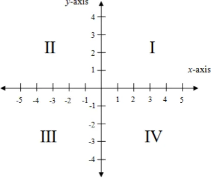
The Cartesian coordinate system (so called the rectangular coordinate system) is a coordinate system used to uniquely describe the location of any points in a plane or in space (Aufmann et al., 2010; Szecsei, 2006). In the plane, this system is formed by one horizontal axis (x-axis) and one vertical axis (y-axis), which intersect at the zero point called origin (Aufmann et al., 2010). In this system, an ordered pair of the form (x,y) indicates the location of a point, where x represents the horizontal distance between the point and the y-axis, while y represents the vertical distance between the point and the x-axis (Szecsei, 2006). The axes divide the plane into four regions called quadrants (see figure 2.1). Any point in quadrant I have both positive x- and y-coordinate, so that it also called as positive quadrant.
Figure 2. 1 The Cartesian coordinate with four quadrants numbered I, II, III, and IV
reinvention of the Cartesian coordinate by designing sequential learning activities. However, considering the complexity of the design, this study merely focuses on the positive quadrant of a Cartesian coordinate. It means that only positive numbers are on the axes such that the coordinate of a point is described as an ordered pair (x,y), where x and y are positive numbers.
2. 2. The Importance of the Coordinate System
The coordinate system plays a fundamental role in many aspects of a children’s
world at school and their daily lives. The skills of reading maps as well as working with graph simultaneously integrated in mathematics and science
teaching really rely on children’s understanding of the coordinate system
(Somerville & Bryant, 1985; Blades & Spencer, 2001; Sarama et al., 2003). According to Somerville & Bryant (1985), maps and graphs typically use the concept of the coordinate system in which the location of any points in space is determined by the intersection of two extrapolating lines from positions on both vertical and horizontal axes. Suppose that children are asked to graph the relationship between the distances a car has driven represented in the vertical axis and the time represented in the horizontal axis. To plot each point, students need to envision lines extending horizontally from the vertical axis and vertically from the horizontal axis and figure out where they intersect. Similarly, in a map, a certain position in the map can be specified from the intersection of its longitude represented in the vertical axis and its latitude represented in the horizontal axis.
The embodiment of the coordinate system in people’s daily live is also embedded
7
Understanding the coordinate system also contributes to the development of spatial ability, in particular spatial orientation (Clements & Sarama, 2009). In
people’s live, spatial orientation is simply about knowing where we are and how to move around the world (Clements & Sarama, 2009). When this simple concept is defined further, it emphasizes the understanding of the relationships between different positions in space firstly the position with respect to our own position and our movement through it, and secondly different positions from an abstract viewpoint including a map and coordinate system (Clements & Sarama, 2009).
2. 3. Students’ Difficulty in Understanding the Coordinate System
Children’s difficulty in learning the coordinate system is inseparable from the debate on the age at which children first grasp coordinates (Blades & Spencer, 2001). Piaget et. al (1960) and Carlson (1976) affirmed that children are able to use the coordinate system after the age 8 or 10 years old. On the other hand, some studies revealed that children at age 4 until 6 years old initiated to use the coordinate system (Somerville & Bryant, 1985; Blades & Spencer, 2001). This discrepancy, according to Blades & Spencer (2001), is grounded on the
complexity of the tasks used to examine children’s performance. Rather than
providing a ready-made grid in the coordinate tasks (Somerville & Bryant, 1985; Blades & Spencer, 2001), Piaget et al. (1960) and Carlson (1976) allowed the children to construct their own coordinate grid using measurement equipment when dealing with the tasks. Children may have trouble to get the solution that need the construction of the grids. Consequently, only relatively older children seemed to be able to do the tasks (Blades & Spencer, 2001).
example demonstrates that those children could not use the numerals on the axes for determining the length (Carpenter & Moser, 1984; Stefie & Cobb, 1988 cited by Sarama & Clements, 2003).
A common misconception that children have is about plotting and describing any points in the form of ordered pairs (Sarama & Clements, 2003). In certain tasks, children initially tend to plot a point from the previous point they have, not from the origin. For instance, if they had plotted a point at (15, 10) and the next point was at (4, 0), they would place the points 4 units to the right of (15, 10), at (19, 10). In describing the points, they also had initial errors such as verbally reading (13, 17) as if it was 13.17 or 13/17. This mistake could happen because they have a tendency to label a point with a single numeral or understand coordinates as separate entities (Sarama & Clements, 2003). A more common mistake was reversing the value of x and y in ordered pairs when a certain point had zero as one of its coordinates (Sarama & Clements, 2003). For example, a point, which was at (5, 0), was described at (0,5) or vice versa.
The number zero within all aspects of the coordinate system causes particular problems for children (Sarama & Clements, 2003). For example, students have difficulties in understanding the meaning of zero in the coordinate system by
asking, “What is zero for?” They may assume that label zero belong in a corner,
even if the grid has four quadrants. Moreover, most children also argued that origin could be represented by one zero, instead of two numbers in the form of (0, 0) (Sarama & Clements, 2003). This misconception happened because of they do not understand that that the number zero actually labels the axes which is why the origin is described by two numbers in the form of (0, 0).
2. 4. Realistic Mathematics Education
9
2. 4. 1. Five Tenets of Realistic Mathematics Education
The process of designing a sequence of instructional activities was inspired by five tenets of realistic mathematics education defined by Treffers (1987) that are described as follows.
1. Phenomenological exploration
The starting point of mathematics learning in RME is allowing students to immediately be engaged in the contextual problems. The contextual problem refers to situational problems that are experientially real to the students not only in their life situation, but also in their mind. According to Sarama & Clements (2003), contextual problems play an important role in teaching the coordinate system, but it must be anchored with well-articulated mathematical goals and instructions. In addition, the coordinate system related tasks embedded in contextual problems help children to understand (Blades & Spencer, 2001). Accordingly, the contextual problem of city blocks in this study is used to help students reinvent and understand about the first quadrant of the Cartesian coordinate system in the form of rectangular grids. Afterward, the context of finding the location of a sunken ship in a sea map allows students to understand the Cartesian coordinate system without the manifestation of the rectangular grids anymore. Even students in Indonesia probably not get familiar enough with the context of city blocks, they may easily engage with the context as long as it is introduced well such that the students can imagine it. In addition, the context related to city blocks in some aspects is also embedded in a certain electronic game such as SimCity or City Block that might be well known enough for children.
2. The use of models or bridging by vertical instruments
of points using the first quadrant of the Cartesian coordinate system. Consequently, the activity about a taxicab distance embedded in the rectangular grids in this study was drawn as the bridging activities to elicit
students’ understanding of the positive quadrant of the Cartesian coordinate. 3. Students’ own constructions and productions
The freedom for students to construct their own strategies leads them to the productions of various solutions that can be used to consider the learning
course. The students’ own strategies or solutions in each learning activity are
discussed in class to eventually support students’ understanding of the first quadrant of the Cartesian coordinate. Accordingly, a student-made system for labeling city blocks, as the basic emergence of the alphanumeric grid system, is a prior activity before learning about the first quadrant of the Cartesian
coordinate. Afterward, students’ own strategies of locating of an object in the city blocks using a pair of numbers (related to the horizontal and vertical distances) will be a prior stage before being introduced to an ordered pair.
4. Interactivity
Similar to social interaction, the learning process requires extensive communication among individuals in the classroom to make it effective. It can be realized through group work or a classroom discussion since the students have the opportunity to share their opinions with the others. Moreover, it also evokes reflections of the students such that it can improve their understanding of particular concepts or ideas. For this reason, this study opens more space for students to have interactivity by working in groups or pairs and conducting classroom discussions for each activity.
5. Intertwinement of various learning strands
11
of the Cartesian coordinate system, but also about other topics such as science and geography. Here, the students will simultaneously learn a taxicab distance (the informal concept of vector), angle measurement, cardinal directions (north, east, south, and wet), and an artificial map.
2. 4. 2. Guided Reinvention
Freudenthal’s idea about “mathematics as human activity” provide insight into a
viewpoint that students should be given an opportunity to reinvent and develop their own mathematics and mathematical thinking and reasoning (Gravemeijer, 2010). Instead of giving mathematical concepts as ready-made product, Treffers (1987) declared that students should be facilitated to reinvent those concepts under the guidance of the teacher and the instructional design. This principle of RME is called guided reinvention. According to Gravemeijer (1994), the term of a guided reinvention implies that students need to experience mathematics learning as a process that is similar to the process of inventing mathematics itself.
According to Bakker (2004), mathematical instruction that supports the guided reinvention can be designed using three different methods. The first method is what Freudenthal called as a “thought experiment”. Here, the designers need to think on how they could have reinvented the mathematical issue by themselves. Consequently, it can inspire them to design the intended mathematical instruction. The second method is studying the history of how the mathematical issue is invented, which is called historical phenomenology. The third method, elaborated
by Streefland (1991), is using students’ informal strategies as a source. Here, the
teachers as well as the designers need to think on how they can support students’
solutions in getting closer to the main goal. In this study, we elaborate the first and the third method, which mainly focus on three notions as elaborated below.
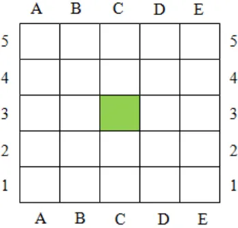
1. Alphanumeric grid system
from the bottom left hand corner of the grid and locate the letters across the bottom of the grid (Booker et al., 2014). Using this system, we can identify the location in the form of cells as co-ordinates as shown in figure 2.2 below.
Figure 2. 2 Alphanumeric Grid System Showing C3
The ability to use this grid system turns out to be an important component of spatial structuring, which refers to the mental operation of constructing an organization for a set of objects in space (Ministry of education, 2008; Clements & Sarama, 2009). In this case, children may first perceive a grid as a collection of cells in the form of squares, rather than as sets of perpendicular lines. According to Booker et al. (2014), a similar system with the alphanumeric grid system is employed to identify a certain local area that includes several building such as the school, the local park, etc.
13
2. Reinventing the positive quadrant of the Cartesian coordinate system
In this study, the notion of reinventing the positive quadrant of the Cartesian coordinate can be associated with interpreting the grid lines in the rectangular grid as number lines only consisting of positive integers. To come up with this idea, we need to coordinate the idea of the distance relationship within the rectangular grid that is embodied in the concept of taxicab distance. Before working with this idea, however, students need to conceptualize the grid as a set of perpendicular lines, not as a collection of cells anymore as in the alphanumeric grid system (Clements & Sarama, 2009). Here, students are invited to interpret the street map of the city block as the rectangular grid that consists of a set of perpendicular lines (de Lange et al., 1997).
As mentioned before, to bridge the students up to interpret the grid lines as rulers, the concept of taxicab distance is employed this study. According to de Lange, van Reeuwijk, Feijs & van Galen (1997), the taxicab distance is the distance between two objects, which is calculated along a pathway on a rectangular grid as a taxi-cab would drive (see figure 2.3). With many possible taxicab routes from object A to B, the taxicab distance between A and B can be easily determined by adding the horizontal distance and the vertical distance (see the right part of figure 2.3).
Figure 2. 3 The example of taxicab routes from point A to B
In the context of the city blocks, we design an activity in which students are asked to investigate that the shortest paths between two objects in the city blocks with the same starting and ending points cover the same taxicab distance, which involve the horizontal and the vertical distance. The role of the taxicab distance here can bridge them up to make a system that can help them to easily find the shortest distance between two any objects on the street map. When determining both the horizontal and the vertical distances, students are expected to interpret the grid lines as number lines or rules that consist of whole numbers. Consequently, the students are wittingly guided to reinvent the first quadrant of the Cartesian coordinate system
3. Locating and plotting any points in the first quadrant of the Cartesian
coordinate system using ordered pairs
Locating and plotting points in the form of an ordered pair (x, y) become very important when students learn about the Cartesian coordinate system. At first, students are asked to describe the location of a certain object using a pair of numbers as the representation of the horizontal and the vertical distance. This will be a preliminary activity before students are introduced to the use of an ordered pair. To understand how this notation works for locating objects, students are challenged to an issue about which distance (the horizontal or the vertical) that should be considered as the first and the second coordinate of the ordered pair. This activity will lead them to an agreement about which distance that should be notated as the first coordinate.
15
The understanding of the Cartesian coordinate plays an important role to be able to do graph work, one of which is making graphs (Somerville & Bryant, 1985; Blades & Spencer, 2001; Sarama et al., 2003). In this study, students start to make a simple graph (a special quadrilateral figure) through locating and plotting points on the first quadrant of the Cartesian plane.
2. 5. The Role of the Teacher
According to Gravemeijer (1994), realistic mathematics education (RME) positions the students different from the traditional learning approaches. Here, students are expected to be more independent, to not just keep asking for approval of their answer or guidance of a procedural solution. Indeed, the students are expected to be able to explain or justify their solution, understand the solution of
others, and ask for explanation if needed. The change within the student’s role significantly depends on the change of the teacher’s role (Gravemeijer, 1994;
Wanty et al., 2010; Cobb & Yackel, 1990). The responsibility of the teacher as the authority and the single source of knowledge have shifted towards being the
facilitator of students’ learning by initiating and guiding discussion (Gravemeijer,
1994; Wanty et al., 2010). According to Wanty et al. (2010), the transformation of
the teacher’s role can be described in terms of social and socio-mathematical norms in the classroom as elaborated below.
2. 6. Social Norms
The social norms in the classroom are defined as the expected manner of acting and explaining that is customized through a compromise between the teacher and students (Gravemeijer & Cobb, 2006). The role of the teacher in the traditional classroom is to explain and validate, while the social norms encompass the
Accordingly, the role of the teacher in this study is asking probing questions that allow students to decide and reason whether an answer is right or wrong and whether their explanation is acknowledged or not in the class. Besides asking probing questions, the teacher is required to create a learning environment that can
bring students’ ideas and solutions as the focus of the classroom discussion. In
this case, after having working groups for each learning activity, the teacher asks some representational groups to present their work, while the other groups are provoked to ask questions, or making remarks, or suggestions.
2. 7. Socio-mathematical Norms
Socio-mathematical norms can be differentiated from social norms as the expected ways of acting and explaining that are specific to mathematics. According to Yackel & Cobb (1996), socio-mathematical norms refer to normative aspects by which students within the classroom community discuss and justify their mathematical work. The socio-mathematical norms itself comprise what is considered a different, a sophisticated and an efficient mathematical solution, and an acceptable mathematical explanation and justification (Gravemeijer & Cobb, 2006; Yackel & Cobb, 1996). In this case, students need to develop their personal ways of judging their mathematical work that counts as different, sophisticated, efficient, or acceptable through negotiations within the classroom discourse (Gravemeijer & Cobb, 2006; Yackel & Cobb, 1996).
Accordingly, the role of the teacher in this study is asking alternatives solutions of given problems during the lesson such that the students can explore their personal ways of what counts as difference solutions. Moreover, the teacher is required to
react with enthusiastic response to the student’s solution that can be interpreted as
17
2. 8. The Coordinate System in the Indonesian Curriculum
Based on the Indonesian Curriculum 2013, the Cartesian coordinate system is taught in 6th grades to approximately 11 -12 year-old students in the second semester (Depdiknas, 2006). The following table 2.1 shows the standard and basic competence of the Cartesian coordinate system in the Indonesian curriculum.
Table 2. 1The Standard and the Basic Competence of the Cartesian coordinate
Standard Competence Basic Competence
3. Using the coordinate system in solving mathematics problems
6.2 Knowing the coordinate of an object
6.3 Determining the location or the coordinate of a point in the Cartesian coordinate system
It is common in Indonesia that the coordinate system is introduced as a ready-made system that needs to be understood by remembering the rule, the procedure, and the notation as well (Palupi, 2013). For instance, to introduce a grid system as the prior knowledge to understand the Cartesian coordinate system, students are given a ready-made system that uses the combination of letters and numbers to describe the position of objects within the grid (Depdiknas, 2006). In this case, the
students only need to remember the rule how to determine the object’s position
correctly. Moreover, the Cartesian coordinate system is also presented as a ready-made system formed by one horizontal axis (x-axis) and one vertical axis (y-axis), which intersects at the origin (Depdiknas, 2006). Similarly, the students only need to remember how an ordered pair works to describe and plot points in the Cartesian coordinate system.
location. Moreover, after learning the Cartesian coordinate system directly at the formal level, students are not given any meaningful tasks to learn to apply the use of the coordinate system in other contexts (Depdiknas, 2006).
The common way of teaching the coordinate system topic as a ready-made system with a lack of applications seems to be an important reason to improve that way of teaching. To make it happen, this study focuses on designing sequential learning activities that can promote the reinvention of the topic of the Cartesian coordinate system in the 5th grade of primary school. Rich contexts that are frequently encountered in Indonesia are also used for reinventing and at the same for applying the concept of the coordinate system in students’ daily lives.
2. 9. Research Aims and Research Questions
19
CHAPTER III
METHODOLOGY
3. 1 Research Approach
The main concern of this study is to improve mathematics education in Indonesia by designing new innovative materials and a grounded theory on learning about the Cartesian coordinate. Accordingly, the aim of this study is to contribute a local
instructional theory that supports students’ conceptual understanding about the
positive quadrant of the Cartesian coordinate in fifth grades. To achieve the aim, we develop innovative educational materials based on realistic mathematics education (RME) approach and conduct iteratively adjustments on it. It implies that we need the design of instructional materials and the research on how these materials support students understanding the concept. Therefore, the methodology of this research falls under design research approach. This approach provides a methodology to understand whether the developed instructional materials support
students’ understanding about the first quadrant of the coordinate system and how
those materials work well in the natural setting of a classroom.
One of crucial characteristics of design research is its cyclic-iterative that is distinguished into macro cycles and micro cycles (van Eerde, 2013). In general, a macro cycle consists of three phases: preparation for the experiment, teaching experiment, and retrospective analysis (Gravemeijer & Cobb, 2006). Meanwhile, a micro cycle refers to a set of problems and activities that are conducted within one lesson. The three phases of the macro cycle will be described below.
3. 1. 1 Preparation and Design Phase
about the topic of the first quadrant of the Cartesian coordinate system is performed to identify the disclosure of the relevant studies on the topic, the
common way of the topic is taught, and the students’ difficulties related to the
topic. Consequently, we can define the knowledge gap and formulate the research aim and the general research question of our study.
For the development of a hypothetical learning trajectory (HLT) related to the topic of this current study, we employ a variety sources to design a set of instructional activities with specific goals for each activity. The specific tenets (Treffers, 1987) and design heuristic about the guided reinvention (Gravemeijer, 1994) for realistic mathematics education (RME) propose a basic framework to design the instructional activities related to our topic. Other sources such as the former studies, textbooks, and website also offer a general base for the design.
During designing the activities, we make the conjectures of students’ thinking and the teacher’s actions on how to guide the learning process. All of this together will be the initial HLT. It will be tested during the teaching experiment and iteratively
adjusted based on the students’ actual learning process.
3. 1. 2 Teaching Experiment Phase
According to Gravemeijer & Cobb (2006), the purpose of the teaching experiment is to test and improve the HLT and to develop an understanding of how it works in the actual learning process. To achieve these aims, the teaching experiment in this study is only conducted within two cycles because we have very limited time for the data analysis. Consequently, it is wise not to collect excessively data during the teaching experiment.
21
During the completely second cycle, the researcher and the teacher discuss about how upcoming activities should be conducted. The aim is to make clear the important aspects of the learning activity that the teacher should focus on. In addition, the reflections concerning the strong as well as the weakest points of each learning activity are also discussed. This discussion is conducted to get important information used to revise and adjust HLT.
3. 1. 3 Retrospective Analysis Phase
According to Gravemeijer & Cobb (2006), the aim of retrospective analysis depends on the theoretical intent of the design research. One of it is to contribute to the development of a local instructional theory (van den Akker et al., 2006). The data from the teaching experiment are prepared for analysis with HLT as the guideline for the focus of the analysis. During the analysis, we confront the actual learning that observed in the classroom with the learning conjectures described in the HLT. The analysis is not merely about the cases that verify the conjectures, but also the ones that contradict with it. Based on the result of the analysis, we can draw the conclusion of the study and answer the research questions.
In this study, the retrospective analysis falls under the constant comparative method. In this method, the researcher first listen video recordings or watch the videotapes and read the entire transcript chronologically (Bakker & van Eerde, 2013). After that, several interesting fragments are selected to propose assumptions. The assumptions are tested against the other episodes to get confirmation or counter-examples. To get the final assumptions, the researcher can reiterate the assumptions process several times and conduct peer-examination.
3. 2 Data Collection
3. 2. 1 Preparation and Design Phase
To connect the designed instructional activities with students’ current knowledge,
accomplishing the teaching experiment, we also conduct a post-test to obtain
some data of the change in students’ understanding about our topic.
The data collection in this phase is also aimed to gain insight into classroom conditions. To achieve this aim, we conduct an interview with the teacher (see Appendix A) and a classroom observation (see Appendix B). During the
interview, we collect data about teacher’s belief and experience, classroom
management, classroom norms, students’ prerequisite knowledge related to the
given topic. The classroom observation is also conducted to compare in addition to what we have already obtained from teacher interview scheme. At this time, we draw the direct evidence what actually happens in the classroom. To get reliable data, we make an audio registration and field notes during both the interview and the classroom observation. All of the data gathered during this preparation phase will be used to adjust and revise the HLT if needed
3. 2. 2 Preliminary Teaching Experiment (cycle 1)
The preliminary teaching experiment, functioned as the pilot study, is mainly
aimed to get an insight about students’ thinking about the problems described in
HLT and to test the conjectures about it. This preliminary teaching is conducted by implementing the initial HLT with a small group of five students as the participants and the researcher as the teacher. The students in the pilot study must be different from the students participating in the actual teaching experiment, but they should not differ too much in their knowledge. As such, they can follow the sequence of learning well and none of them dominates the lesson too much.
During the preliminary teaching, we collect video registration of classroom
activities, make field notes about students’ activities, and collect students’ written
work. All of these data are analyzed to compare the result with our initial HLT.
23
3. 2. 3 Teaching Experiment (cycle 2)
In the second cycle of teaching experiment, the revised HLT is implemented in the real classroom environment with the participants are students of fifth grade. The regular teacher conducts the whole lessons, meanwhile the researcher who acts as observers is assigned to conduct a video registrations of the classroom observation, makes field notes, and collects students’ written work. The class observations are collected to analyze whether the conjectures in the revised HLT are certainly fulfilled or certain issues come out to revise the instructional activities in some extend. In practice, one dynamic video camera that can moves around is used to record all of the learning activities during the whole lessons.
To get more insight into students’ thinking and reasoning, short discussions with a
focus group is also performed. The focus group itself consists of 3-5 students who have average level of understanding based on the result of pre-test and teacher interview. It is essential to have a focus group here since we cannot capture and
analyze all of students’ thinking and reasoning in the class. By focusing only on
one group, we have an inclusive students’ thinking during the teaching
experiment. However, the data of the whole group can be used merely as source for additional interpretation. In practice, the short discussions with the focus group will be recorded by using one static camera.
In the end, all of the data collected during this second cycle will be prepared to be analyzed in retrospective analysis. The result of the analysis, later on, will be used to final revise of the HLT. It is also used to answer the general research question
about how we can support students’ understanding of the first quadrant of the
Cartesian coordinate system.
3. 2. 4 Pretest and Posttest
A pretest is performed to get information about the students’ initial knowledge
items used in both pretest are the same and they are designed in such way we can
examine students’ strategies in solving coordinate system related problems. Some
of the items in the pretest will be elaborated in the lesson during teaching experiment. The level of difficulties such as easy, intermediate, and difficult are also considered during designing the items of the pretest.
To assess students’ acquisition of knowledge about rectangular coordinate system,
we also conduct a posttest (see Appendix D) in the end of the instructional sequence in either the first cycle or the second cycle. The items used in the posttest are mostly similar to the items in the pretest. The modifying are only occurred in the parts of the context and the numerals on the given problems. The importance of conducting a pre-test and a post-test in the first cycle (preliminary teaching) is to ensure whether the items on both pretest and posttest are understandable or not. As such, we can make a necessary revision before we have them on the second cycle (teaching experiment). In addition, the pre-test in both cycles is also performed to assess the starting points of the students.
3. 2. 5 Validity and Reliability
25
3. 3 Data Analysis
3. 3. 1 Pretest
The analysis of the pretest is aimed to get information about students’ current relevant knowledge and identify students’ starting points about the first quadrant
of the Cartesian coordinate system. The result of the pretest is analyzed based on the rubric we develop as a guideline (see Appendix G) without performing any
statistical analysis at all. We also analyze the results of the students’ written work
qualitatively by considering their reasoning in solving the problems. The result of the analysis will be used to do some adjustment in the initial HLT so that it is
appropriate with the students’ starting points. Moreover, the result is also utilized
to select the focus group consisting of students with various level of knowledge related the topic of the first quadrant of the Cartesian coordinate system.
3. 3. 2 Preliminary-Teaching (cycle 1)
The data collected from the preliminary teaching such as students’ written work and the video registration is used to examine the students’ learning process. The learning process is investigated by testing the conjectures stated in the initial HLT. At first, we watch all of the video registration and focus our intention on the interesting fragments. What we meant by interesting fragment is a video fragment
in which we can observe the students’ way of thinking in achieving the learning goals. However, it also can be a fragment that shows students’ struggles attempted
to find the solution of the given problem. After that, we need to make the transcript of the selected fragments and analyze these. In the end, the result of the observed learning based on the analysis of classroom observation supported with
students’ written work are compared to the conjectured learning in our initial
HLT. In this sense, it can be noticed which conjectures is really occurred and which one is not.
From the whole analysis above, we can draw a conclusion whether our designed
instructional sequence support students’ understanding of the concept of the first
investigate students’ difficulties encountered during the lesson and evaluate the
language and the instruction we used in the worksheets. All of these evaluations are employed to revise and improve our initial HLT before carrying it out in the real teaching experiment.
3. 3. 3 Teaching Experiment (cycle 2)
Similar to the analysis in the preliminary teaching, the video recording of
students’ activity in both the focus group and the class observation is used to
investigate the learning process. Accordingly, the selected interesting fragments
are transcribed to provide the interpretation of students’ thinking. In addition, the
selected fragments together with students’ written work are analyzed and
compared with the conjectures in the revised HLT from the first cycle. The result of the analysis, later on, is employed to answer the research questions, derive conclusions, and revise or improve the existing HLT.
3. 3. 4 Posttest
The method we analyze the result of the posttest is similar to what we do in the pretest. However, the results of the posttest are also compared with the result of pretest. This analysis is aimed to investigate whether the students have already achieved the learning goals for the lessons. Here, we analyze the way students, solve the given problem, and the strategy they use. The result of this analysis can be employed to provide additional information in deriving the conclusion and to answer the research questions of this study.
3. 4 Validity and Reliability
3. 4. 1 Internal validity
The internal validity concerns about the quality of the data that has led to the conclusion (Guba, 1981 cited in Bakker & van Eerde). In this study, we analyze
several data from video registrations, field notes, students’ written works, and
27
3. 4. 2 External and Ecological validity
The external validity, closely interpreted as the generalizabilty, refers to the question of how we can generalize the results from certain contexts to be functional for other contexts (Bakker & van Eerde, 2013). By giving the results of instructional theory, the HLT, and the educational activities as instances of something more general, others can adjust these to their local contingencies. In addition, in term of ecological validity, it refers to the extent to which the results of a study can be generalized to real condition. The implementation of our learning design in the real classroom situation, where the regular teacher of that class is teaching, contributes to the ecological validity.
3. 4. 3 Internal reliability
The internal reliability refers to the degree of independence of the researcher about how the data collected and analyzed (Bakker & van Eerde, 2013). The internal reliability in this study can be improved by discussing the critical fragments with colleagues, called inter-subjectivity, about the interpretations and conclusions during retrospective analysis.
3. 4. 4 External reliability
In design research, the external reliability is interpreted as “trackability” or “transparency”, which means that the readers must be able to track the whole
process of the study (Bakker & van Eerde, 2013). In this sense, the clear explanation of how the study has been, how the data are analyzed, and how the conclusions have been derived can improve the external reliability. It is because the readers can easily track the whole process of this study.
3. 5 Research Subject
3. 6 Timeline of the Research
The timeline of the study is summarized in the following table.
Table 3. 1 Timeline of the Research
Date Description teacher and communicating the detail of the study with the teacher
Preliminary Teaching Experiment Phase (Cycle 1) 1st meeting 16 February 2015 Pre-test (initial version)
2nd meeting 17 February 2015 Interview to clarify students’ answer on the pre-test items
3rd meeting 18 February 2015 Activity 1: Labeling blocks of city blocks 4th meeting 20 February 2015 Activity 2: Chess notation
5th meeting 23 February 2015 Activity 3: Taxicab routes and distance 6th meeting 25 February 2015 Activity 4: How to use an ordered pair? 7th meeting 26 February 2015 Activity 5: Cartesian coordinate system
(positive quadrant) 8th meeting 27 February 2015 Post-test (initial version)
9th meeting 28 February 2015 Interview to clarify students’ answer on the pre-test items
Teaching Experiment (Cycle 2) 1st meeting 12 March 2015 Pre-test (initial version) 2nd meeting 13 – 14 March
2015
Interview to clarify students’ answer on the pre-test items
3rd meeting 24 March 2015 Activity 1: Labeling blocks of city blocks 4th meeting 25 March 2015 Activity 2: Chess notation
5th meeting 31 March 2015 Activity 3: Taxicab routes and distance 6th meeting 1 April 2015 Activity 4: How to use an ordered pair? 7th meeting 2 April 2015 Activity 5: Cartesian coordinate system
(positive quadrant) 8th meeting 2 April 2015 Post-test (initial version)