L R
U.S. N C C:
M C E
N H
C R C U R I
January 2008
Glenn Ricci, Pam Rubinoff, and Angela Wilson Coastal Resources Center
University of Rhode Island
Suggested citation:
Table of Contents
Priority Issues of the Primary Audience in the Northeast Region... 4
Management of Coastal Ecosystems ... 7
Defining Marine Ecosystem-Based Management... 7
Overview of Ecosystem-Based Coastal Management Initiatives–U.S. Northeast... 9
Water Quality and Nutrient Reduction... 11
Habitat Protection... 13
Restoration of Nearshore Habitat... 14
Ocean Resources/Living Resources... 15
Education... 16
Tools... 17
Coastal Hazards Resilience... 19
Overview of Federal and Regional Programs... 20
Regional Hazard Risks... 23
Vunerability Assessment... 25
Planning and Regulation... 30
Mitigation... 33
Response and Rebuilding... 35
Education... 36
Tools... 37
Cross-Cutting Issues of Data and Information Access and Usability... 40
Communication and Coordination... 40
Access... 41
Usability... 41
Priority Issues of the Primary Audience in the Northeast Region
This report assesses the priority issues of the Northeast coastal resource management community by examining a selection of representative planning documents across the region (Table 1). The Northeast coastal region is heavily urbanized with major
metropolitan centers throughout much of the area. The resulting land development in the urban and, more importantly, suburban and rural areas is creating cumulative impacts to water quality, habitat, and living resources. Hazard issues are a paramount concern throughout the region because of the significant coastal development over the past few decades and the potential impacts from climate change. The region’s state coastal programs have ranked ecosystem impacts and hazards resilience as their primary concerns (Table 2). This is closely followed by the long-running issue of public access and a somewhat new or re-emerging issue of energy siting.
Table 1. Priority Issues in the Northeast Region Based on a Selection of Planning Documents
Northeast Regional Ocean Council – 2007 Annual Report to the Governors of New England
*
* * *
Gulf of Mexico Action Plan
* * *
*
New Hampshire Estuaries Program
* * *
*
Waves of Change: The Massachusetts
Ocean Management Task Force
* * * *
Massachusetts Bay Program
* * *
*
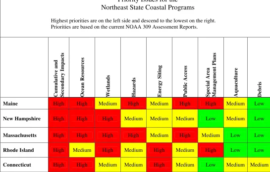
Table 2. Priority Issues for the Northeast State Coastal Programs
Priority Issues for the
Northeast State Coastal Programs
Highest priorities are on the left side and descend to the lowest on the right. Priorities are based on the current NOAA 309 Assessment Reports.
Cum
u
lative and
Secondary Impacts Ocean R
eso
urces
Wetlands Hazards Energy Siting Public Access Special Area Management Plans Aquaculture Debris
Maine High High Medium High Medium High High Medium Low
New Hampshire High High High Medium Medium Medium Low Medium Low
Massachusetts High High High High Medium High Medium Low Low
Rhode Island High Medium High Medium High Medium High Low Low
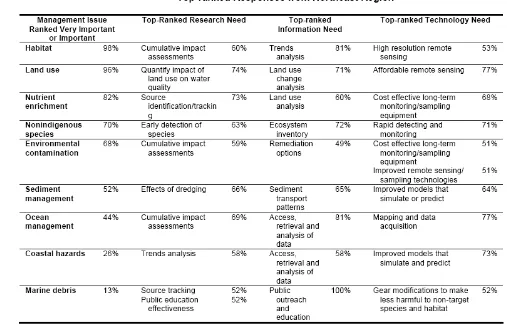
In 2004, the Coastal States Organization (CSO) conducted a national survey of coastal practitioners about their priority issues and needs, specifically research, information, and technology. The results were compiled by region. Below, the Northeast’s results are summarized in the table from the CSO. The results are consistent with other regional needs assessments that are summarized in this literature review. Habitat, land use, and nutrient issues are paramount in the context of understanding the larger ecosystem and the related cumulative impacts of development. If there is one weakness, it would be that these programs tend to favor ecological needs and research over understanding human behavioral change and economic policy options.
Management of Coastal Ecosystems
Defining Marine Ecosystem-Based Management
Part of this literature review focused on initiatives, programs, and needs in the Northeast for marine ecosystem-based management (EBM). There is an increased call and political support for EBM after the U.S. Commission on Ocean Policy released its report calling for a more comprehensive and integrated ecosystem-based approach to address the current and future management challenges (COMPASS 2007). In the box below is a definition of marine EBM by the Communication Partnership for Science and the Sea (COMPASS). This group also produced a list of specific actions that are consistent with the EBM approach. This definition and exemplary actions provided a foundation and point of reference for reviewing documents from the Northeast coastal community.
Definition of EBM
“Ecosystem-based management is an integrated approach to management that considers the entire ecosystem, including humans. The goal of ecosystem-based management is to maintain an ecosystem in a healthy, productive and resilient condition so that it can provide the services humans want and need. Ecosystem-based management differs from current approaches that usually focus on a single species, sector, activity or concern; it considers the cumulative impacts of different sectors.
“Specifically, ecosystem-based management:
• emphasizes the protection of ecosystem structure, functioning, and key processes;
• is place-based in focusing on a specific ecosystem and the range of activities affecting it; explicitly accounts for the interconnectedness within systems, recognizing the importance of interactions between many target species or key services and other non-target species; acknowledges interconnectedness among systems, such as between air, land and sea; and integrates ecological, social, economic, and institutional perspectives, recognizing their strong
Actions Associated with Marine EBM as Identified in the COMPASS Scientific Consensus
The Scientific Consensus Statement on Marine EBM highlighted key overarching actions that are consistent with an ecosystem-based approach to management. The literature review will show that some if not all of these actions are being applied to varying degrees already in the Northeast. However, they are not being implemented in a fully integrated and comprehensive manner that is called for and required for successful EBM.
• Initiate ecosystem-level planning that involves multiple stakeholders and takes into account the cumulative impacts of multiple important human activities on ecosystems, as well as the effects of long-term environmental changes.
• Establish cross-jurisdictional management goals through formal agreements and mechanisms across local, state, federal and tribal authorities.
• Initiate zoning of regions of the ocean, for example Large Marine Ecosystems, by designating areas for particular allowable uses in both space and time, including networks of fully protected marine reserves and other types of marine protected areas.
• Expand and improve the coordination of habitat restoration in coastal ecosystems such as wetlands and seagrass beds.
• Adopt co-management strategies in which governments and diverse stakeholders share the responsibility for management and stewardship.
• Incorporate adaptive management into ecosystem plans as an approach to learning from management actions.
• Establish long-term ocean and coastal observing, monitoring and research programs.
Overview of Ecosystem-Based Coastal Management Initiatives in the U.S. Northeast
Multiple initiatives and programs in the Northeast, from the regional to the local levels, incorporate the ecosystem-based management (EBM) concept. Some of these programs have been operating for a couple of decades like the Rhode Island Special Area
Management Plans (Rhode Island CRMC 2007). These localized efforts are increasing throughout the region. There has also been significant progress at the regional level where several interstate and multi-state initiates are firmly established. These include the Gulf of Maine Council and the Long Island Sound Study. While the scale and boundaries of these initiatives vary, they are all based on EBM concept and principles. Improved technology capacity is increasing the ability to collect and analyze data at the ecosystem level. However, there continues to be limited financial, technical, and political capacity at the local level to implement ecosystem-based coastal management programs
(Massachusetts Office of Coastal Zone Management 2006, New Hampshire Coastal Program 2006).
The Center for Sponsored Coastal Ocean Research (CSCOR 2006) has documented the Northeast region’s many organizations, partnerships, and institutions active in coastal management with a focus on research and technological needs for regional ecosystem research. The CSCOR document also provides a thorough timeline of progress between all the individual surveys and needs assessments for the region. This literature review complements the CSCOR report by summarizing the major elements. Readers should read the CSCOR report for a more detailed overview of the organizations and needs in the Northeast region.
The Northeast Regional Ocean Council (NROC) was established by the New England Governors’ Conference, Inc. in 2005 with the purpose of identifying regional goals and priorities and linking regional ocean management and scientific institutions. NROC helps to link subregional programs for the entire Northeast. This includes longstanding
initiatives such as the Gulf of Maine Council and the Long Island Sound Study. In its 2006 work plan, NROC identified its keys to successful EBM as “possessing adequate information to understand the interrelated nature of ocean and coastal systems, linking that information through modeling and analysis to management and policy decisions, and creating the governance structures to carry out and sustain those decisions.” NROC’s four priority issue areas for 2007 are ocean energy planning and management, ocean and coastal ecosystem health, maritime security, and coastal hazard response and resilience (NROC 2007a).
SNENYOP is coastal hazard resilience and it will be collaborating with NROC at the work group level.
GOMC is continuing its regional work to improve ecosystem-based management through data and mapping initiatives, coordination, and outreach. Partners have identified a need to develop a baseline assessment to better understand the interconnections between human activities and ecosystem goods and services (GOMC 2005). Other data gaps at the regional and local levels include economic valuation of ecosystem services, impacts of climate change, invasive species distribution, patterns of human uses, and critical habitats. As evidenced by the data gaps, there is a recognition that social scientists are mostly absent from the EBM discussions. The goal is to pilot EBM at four sites in the coming years.
The states are also establishing ecosystem-based governance regimes to match the regional initiatives. Stemming from the recommendations for EBM by the U.S.
Commission on Ocean Policy and the Pew Oceans Commission, Massachusetts led the way with the Oceans Report (Massachusetts Ocean Management Task Force 2004) and the ensuing Oceans Partnership Fund (Massachusetts Ocean Partnership Fund 2007) to coordinate the states’ coastal and ocean management activities. This effort is a public-private partnership with the goal of developing an integrated ocean management plan. Tasks include developing and piloting planning frameworks; coordinating the
development of scenario analyses, models, and other tools to support decision making; improving the integration, interoperability, and information management of ocean data, research, and monitoring; and communicating to non-science audiences about ocean ecosystem services. The data network needs include baseline maps of the seafloor, the ecosystem, and human uses. While there is great interest and political will at the state level, there seems to be a lack of funding or expertise at the local level to implement EBM projects (Massachusetts Office of Coastal Zone Management 2006).
Building from Massachusetts’ progress, Maine released its Maine Bays Study (Maine State Planning Office 2007) to evaluate how to improve its nearshore coastal
management programs. Results of the study identify a large gap between the ocean work of the Gulf of Maine Council and the local municipality-based coastal planning. There is a great need for improving regional nearshore management since the current coastal program is not effective for watershed and cross-jurisdictional issues. Maine conducted two pilot programs in Muscongus Bay and Taunton Bay to test the applicability and needs for a new EBM coastal program. The pilots proved successful in generating interest and in specifying needs. The Maine study found a major gap in nearshore data and
information. Locating and gathering the limited data that did exist presented significant challenges. The Maine study sees the potential for the state’s watersheds to act on their own issues, thus avoiding the one-size-fits-all approach of traditional state programs.
Hampshire Dept. Of Environmental Services 2006). Two of the prominent programs are the New Hampshire Estuary Project and the Great Bay National Estuarine Research Reserve.
Rhode Island continues to expand its special area management plan (SAMP) program. In 2004, Rhode Island established the Rhode Island Bays, Rivers, and Watersheds
Coordination Team (Mastrati and others 2004) in an effort to coordinate and integrate policies and plans across state lines. The overarching goal is to apply EBM tools and concepts to improve resource health. This coordination team will link their work to the SNENYOP.
Connecticut’s core EBM initiative is the Long Island Sound Study in partnership with New York (New York. Dept. of State. Division of Coastal Resources 1999). However, the state recognizes that a need remains for expanding their EBM approach.
Connecticut’s key needs are a central agency for the sound, a submerged lands leasing program, and an ocean governance strategy (Connecticut Department of Environmental Protection 2006). They see a regional ocean governance plan as critical to the issue of managing energy facilities.
In addition to these state and regional initiatives in EBM, there are the site-based programs of the federal government. The National Estuary Program (NEP) sites
encompass large nearshore coastal areas in the region. Each site has a management plan that employs watershed-based planning, research, and analysis to address EBM issues. The National Estuarine Research Reserves (NERR) cover less area than the NEPs, but complement them in their research of cumulative and secondary impacts with an ecosystem-based framework. They have a strong public outreach program and coastal training program (Connecticut) that is focused on training local decision makers on EBM concepts and application.
The specific issues, capacity, and needs for components of the Northeast ecosystem are discussed in detail in the following sections.
Water Quality and Nutrient Reduction
Water quality continues to be a major issue identified by all state coastal programs, NEPs, and NERRs. The Northeast coastal corridor is heavily developed, leading to excess nutrients and bacterial and toxic contaminants, mostly from land-based sources. Despite continued development of coastal watersheds, some areas have improved their water quality over the past couple of decades (New Hampshire. Dept of Environmental Services 2006, Massachusetts Office of Coastal Zone Management 2006). Most of this can be attributed to the decline of the manufacturing industry and improved point source pollution control. In the U.S. Environmental Protection Agency’s (EPA) national
Excess nutrients, specifically nitrogen, stem from a combination of sources including wastewater treatment plants in urban areas, stormwater runoff, septic systems, and atmospheric deposition of nitrogen. The management strategy for most of the region has been to reduce nitrogen levels in wastewater treatment plant effluent, employ alternative septic systems, reduce stormwater runoff, and implement low impact development practices (CICEET 2004). Increased nitrogen loadings have resulted in eutrophication in many nearshore embayments. Eutrophic symptoms increasingly being seen in the region include low dissolved-oxygen levels, hypoxia, fish kills, eelgrass loss, macroalgae blooms, and benthic community changes (US EPA 2007). On an ecological level, changes in water quality and temperature have had significant impacts on Long Island Sound and Narragansett Bay, in which scientists are noticing phase shifts in the dominant fish community from bottom-dwelling to water-column species (NBNEP 2007,
Connecticut Department of Environmental Protection 2006).
Bacterial contamination continues to be a major issue for nearshore embayments, causing closures to shellfish beds and public swimming beaches (US EPA 2007). For instance, 22 of Buzzard Bay’s 32 major embayments are listed as impaired because of fecal coliform bacteria (Buzzards Bay Project Committee 1992). Water quality in the central part of the bay is in good condition. Stormwater runoff from nonpoint sources is the principal cause for this in Buzzards Bay and most other sites.
Management of these cumulative and secondary impacts is a common challenge across the region and nationally. Despite new regulations on stormwater management, continued development is increasing the volume of runoff in coastal watersheds. Some states like New Hampshire do not have the authority for site runoff permits, so there is little capacity to help local communities develop their stormwater management plans (New Hampshire Dept. of Environmental Services 2006). Resources to help with enforcement are also limited. Implementation is dependent on the skills, knowledge, and resources of each individual municipality. In response, New Hampshire is developing a wetland assessment and monitoring program to understand the impact of stormwater on wetland function and creating wetland water-quality standards (New Hampshire Dept. of
Environmental Services 2006).
Regionally, the Gulf of Maine Gulfwatch program monitors water quality and
contaminants from over 60 sites (GOMC 2007). The Gulf of Maine would like to use these data to educate the public about the effects of lifestyle choices on the Gulf. The data will also provide managers with excellent environmental reporting and ecosystem
indicators.
2006). Research is also needed in assessing the impacts of nitrogen reduction on ecosystems now that governments are focusing their funding on combined sewer overflow issues and wastewater treatment plants (Costa-Pierce et al 2005).
Habitat Protection
Coastal habitat health and coverage are continuing to decline in the Northeast region despite stronger regulations and enforcement. Causes of habitat loss are attributed to eutrophication, hypoxia, altered hydrology, development, fill, invasive species, sudden marsh dieback, and sea level rise. In Massachusetts Bay, runoff and other impacts cause approximately 1,000 acres of coastal and inland wetlands to be lost each year
(Massachusetts Bays Program 2003). In Long Island Sound, the loss of tidal marshes to sea level rise is far greater than previously estimated (LISS 2003b).
The key management challenge is that most of the impacts to nearshore habitats are from cumulative and secondary sources of pollution. Therefore, most of the state coastal programs rate cumulative and secondary impacts as their highest management priority. Strategies are a mixture of addressing the sources and protecting the habitat area. For instance, Rhode Island is revising its buffer policy to better suit the context of urban areas, since they were not designed to accommodate the large-scale redevelopment activities (Rhode Island Coastal Resources Management Program 2006).
Most of the coastal programs are citing the need for more baseline data on the health and spatial distribution of habitat resources. The Gulf of Maine developed ecosystem health indicators in 2003 in an effort to collect data using a Web-based reporting system. Major categories of indicators include coastal development, pathogens and contaminants, eutrophication, aquatic habitat, fisheries and aquaculture, and climate change (GOMC 2007).
Scientists are developing cost-effective methods for delineating wetland coverage and condition using remote-sensing satellite imagery with in-situ radiometry and field data (Rozsa 2007). The Long Island Sound Study has funded a long-term program to monitor the elevation dynamics of the wetlands using surface elevation tables (LISS 2003b). These tools will help measure the changes in wetland surface elevation and
sedimentation. These data could also be used by states to develop targeted restoration plans (Rhode Island CRMC 2006a). Data are also needed on the presence and impact of aquatic nuisance species (Rhode Island CRMC 2006a).
Most of the coastal programs have identified their key data and mapping needs in relation to coastal habitat. As recommended by Maine after the state attempted pilot EBM
• Spatial data on benthic habitat, ecological units, and human uses such as fishing, runoff, and habitat alterations;
• Understanding natural variability and its causes in estuarine ecosystems; • Trajectory models of harmful algae blooms;
• Mesoscale hydrodynamic models for Northeast estuaries and embayments; • Nitrogen attenuation/loss coefficients by source for wetlands and groundwater
transport;
• Assessment of overall eutrophic condition and human influences; and • Assessing long-term shoreline change in the region to develop mitigation
strategies
Restoration of Nearshore Habitat
As part of the larger strategy to protect and restore coastal ecosystem services, the region has invested significant resources in the restoration of nearshore habitats. Most of the focus and success has been on salt marsh restoration (New Hampshire Coastal Program 2006, Rhode Island CRMC 2006b). Salt marsh restoration programs have been effective in combining knowledge, skills, and partnerships, resulting in increased coverage area. Eelgrass habitat restoration is a new target area, though less knowledge and skills exist (Rhode Island CRMC 2006a Massachusetts Office of Coastal ZoneManagement 2006). Additional research and small-scale restoration pilots are needed to determine which techniques are most effective (Massachusetts Office of Coastal Zone Management 2006).
New Hampshire is shifting its successful restoration program inland to rivers and
freshwater wetlands draining into the estuaries (New Hampshire Coastal Program 2006). This would include dam removal to increase anadromous fish passages and allow tidal influences to extend further upstream. There is a need in that state to expand restoration technical assistance to all coastal watersheds by working with watershed groups on implementing river restoration projects (University of New Hampshire. Sea Grant College Program 2007). In the coastal zone, the New Hampshire Coastal Invasives Program was created to control invasive species at sites of high ecological value by evaluating their impact on restoration sites (New Hampshire Coastal Program 2006).
Rhode Island is facing an urgent need to develop low-cost methods to dispose of dredged materials (Costa-Pierce and others 2005). Research is needed to determine the feasibility of using dredged materials in ecosystem restoration projects.
Ocean Resources and Living Resources
From an EBM perspective, there are significant changes to the health and allocation of coastal and ocean resources. Most states are experiencing reductions in shellfish
populations due to a combination of overharvesting, bacteria contamination, and hypoxia (Massachusetts Bays Program 2003, New Hampshire Estuaries Project 2007,
Narragansett Bay Estuary Program 2007). In Connecticut, diseases have caused widespread economic losses with the transmittal of marine pathogens from cultured shellfish to native stocks (University of Connecticut. Sea Grant College Program 2006). There have also been large lobster die-offs (Connecticut Department of Environmental Protection 2006).
Warming waters and hypoxia have also had an effect on the types of finfish dominating nearshore waters. Long Island Sound and Narragansett Bay have both recognized a phase shift to warmer-water and water-column finfish species (LISS 2003b, Rhode Island DEM 2003).
For fisheries data and observations, coastal managers stated two central needs in the Northeast Regional Association of Coastal Ocean Observing Systems (NERACOOS) assessment (Keeley Group 2006):
1. On-line tools that integrate known migratory patterns, aerial surveys, and the real-time presence of phytoplankton to identify prime frontal boundary conditions; and 2. Data to predict migratory paths and timing in support of fisheries surveys for
stock assessments and management plans.
informed and comprehensible manner (New Hampshire Coastal Program 2006). Coupled with these data and capacity issues are the need for new policies that provide enforcement capabilities and common assessment methodologies (New Hampshire Coastal Program 2006, Massachusetts Oceans Management Task Force 2005).
Education
Education and outreach activities are commonly recognized as valuable components of coastal management. They are even more important when an EBM approach is taken. The Massachusetts EBM initiative calls for a formal commitment to develop a new ocean literacy and stewardship ethic among the public so that citizens can be fully engaged in problem solving (Massachusetts Oceans Management Task Force 2005, Massachusetts Ocean Partnership Fund 2007). Members of the public lack knowledge of EBM issues, such as the impacts of stormwater runoff to the ecosystem (Massachusetts Ocean Partnership Fund 2007, Buzzards Bay Project Committee 1992), and they fail to recognize their role in solving them.
The national Sea Grant program has made EBM a high-priority educational goal. Rhode Island Sea Grant’s strategic plan outlines a strategy for advancing EBM training (Costa- Pierce and others 2005). Connecticut has set a goal of improving marine science literacy (University of Connecticut Sea Grant College Program 2006). Other states have similar programs in their plans (University of Maine Sea Grant College Program 2006,
University of New Hampshire Sea Grant College Program 2007, University of Massachusetts Sea Grant College Program 2006).
The Gulf of Maine has several stated goals to educate the public and local decision-makers—including lawmakers and commercial and recreational users—of the invasive species threat (GOMC 2007). The Gulf of Maine wants to build the capacity of coastal managers for measuring cumulative impacts from runoff by developing decision-support tools on cumulative impacts. Gulf of Maine also needs to promote better communication of methods and case studies for applying natural capital valuation and socioeconomic concepts into EBM decision making.
The NERR sites have detailed needs assessments for local decision makers and
conservation committee members. The issues, needs, and delivery preferences seem to be consistent for the most part across the region. Key issues identified by local decision-makers include erosion, development, water quality, invasive species, and tourism (Dale 2006, McCann 2003). Locals are asking for assistance in understanding laws and
make use of the improved databases and tools now available for decision-making (New Hampshire Coastal Program 2006). The New Hampshire coastal program has adjusted its technical assistance strategy from an ad hoc response to a targeted proactive initiative based on where they can have the greatest impact on resource health (New Hampshire Coastal Program 2006). Maine’s Coastal Training Program is testing a collaborative knowledge network as a mechanism for addressing watershed issues. Expertise is first sorted by eight categories and then group knowledge is gathered using collaborative learning theory and applied to priority issues (Wells Estuarine Research Reserve 2007a).
Tools
The Northeast Regional Ocean Council (NROC), Cooperative Institute for Coastal and Estuarine Environmental Technology (CICEET), Gulf of Maine, and Massachusetts Oceans Report are among many programs that have documented the need for improved EBM tools to assist managers and local decision-makers through state-of-the-art environmental reporting and indicators. NROC (2007a) has called for the expansion of the successful Gulf of Maine Data Partnership Program to all of New England. The Massachusetts Oceans Report (2005) identified a need to develop and implement a common
methodology and standards of analysis for proposed ocean projects that consider the visual, cultural, and aesthetic impacts. This was in clear reference to the wind energy projects proposed for sites off Cape Cod but would be valuable to other states such as Rhode Island that will soon be confronted with the same challenges.
Gulf of Maine convened an EBM meeting for practitioners to identify their needs. The response was to make existing EBM tools more accessible through promoting other initiatives such as the EBM Tools Network and the Nature Conservancy EBM Toolkit (GOMC 2005). Areas where new tools would be needed included Web-based
visualization and decision-support tools, assessment of watershed point and nonpoint sources, mass-loadings, and data integration techniques. Other reports state a need for land use analytical tools that complement the ocean observing system measurements (GOMC 2005). These tools would need to include non-monetary values of open
landscapes and functioning ecosystems in the economic valuation techniques. The Gulf of Maine Advisory Panel proposes incorporating these techniques into state regulations and policies (GOMC 2007).
Several tools are currently in use around the region that focus on addressing EBM issues. In Southeastern Massachusetts, the government worked with the University of
Massachusetts to developing a quantitative tool that links nutrients between the
watershed and embayments (Howes and others 2006). In Long Island Sound, monitoring of the elevation dynamics of tidal marshes due to sea level rise and sedimentation is being conducted using surface elevation tables (LISS 2003b).
analyses the trade-offs to ecosystem services among different management strategies and options. While this tool is still in development, it does provide some ideas and
quantitative methods for calculating the costs and benefits of management decisions on an ecosystem level.
Connecticut Sea Grant developed a nationally recognized program called Nonpoint Education for Municipal Officials (NEMO), which promotes education over regulation as the most effective and cost-effective means for influencing local land use decisions (University of Connecticut Sea Grant College Program 2006). Most states have adopted the NEMO program as well. There are also new partnership programs such as New Hampshire’s Natural Resources Outreach Coalition, which is a multi-organizational initiative offering coordinated assistance to communities (New Hampshire Coastal Program 2006). Most coastal programs realize that they must work with a larger array of partners, beyond the natural resources community, to effect change in local planning.
Coastal Hazards Resilience
This section of the literature review summarizes the issues, capacities, and needs related to natural hazards resilience for the Northeast coastal region. There are many definitions and models for hazards resilience. This literature review uses the following definitions:
Grand Challenges for Disaster Reduction – Subcommittee on Disaster Reduction:
“Disaster Resilience is the capacity of a community exposed to hazards to adapt, by resisting or changing, to reach and maintain an acceptable level of functioning and structure. Resilience is determined by the degree to which the community is capable of organizing itself to increase its capacity for learning from past disasters.” (National Science and Technology Council 2005)
United Nations International Strategy for Disaster Reduction:
“The capacity of a system, community or society potentially exposed to hazards to adapt, by resisting or changing in order to reach and maintain an acceptable level of functioning and structure. This is determined by the degree to which the social system is capable of organizing itself to increase its capacity for learning from past disasters for better future protection and to improve risk reduction measures.” (UN/ISDR 2006 )
NOAA identifies the key capacities for coastal resilience as improved community capacity to prepare, mitigate, respond, and recover from coastal hazards (Nicholson 2006). Some common characteristics of a resilient coastal community have been identified and can be used for sorting through information (Nicholson 2006). These resilience characteristics follow:
• Communities with diverse economic bases; that is, they are not dependent on just one activity;
• Strong community self-management systems, including management zoning to regulate future development and resource development;
• Community members involved in significant community decisions;
• Organizations in the community with developed partnerships and collaborative working relationships;
• Effective management structures for sustainable resource use (e.g., local community, government agencies);
• Strong belief in, support for, and capacity for education at all levels;
• Infrastructure that provides for alternatives: e.g., multiple access roads, various water supply systems, and health systems located in safe areas;
• Areas of natural vegetation deliberately maintained under effective management plans;
• Areas of high risk identified and incorporated into land use plans; and
These characteristics guide this literature review in identifying the issues and needs related to core resilience capacities, including vulnerability assessment, planning and regulation, mitigation, response and redevelopment, education, and technical tools. The review provides an overview of the federal laws and programs that apply across the Northeast region, as well as regional initiatives that address coastal hazards.
A summary of the regional needs for coastal hazards resilience in the Northeast was developed by NROC for the 2007 Ocean Congress. The findings build on several initiatives in the Northeast, including the state coastal programs’ 309 reports, Gulf of Maine Council’s surveys and assessments, NERACOOS user needs, and NROC’s work. The table mirrors the needs found in this literature review.
Northeast Regional Needs for Better Coastal Hazards Response and Resilience:
Handout at the 2007 Ocean Congress
Coastal Hazards
General Needs Desired Outcomes =
Better Response and Resilience General Provide outreach to the public on
coastal hazards.
Increased support for coastal hazards mitigation.
General Create incentives for homeowners to adopt mitigation measures.
Decreased vulnerability in high-hazard areas.
General Develop and implement local hazard mitigation plans.
Communities eligible for grants and emergency assistance from FEMA.
Erosion Calculate shoreline change rates. Improved performance standards and regulations including setbacks.
Erosion Track sediment loss from the beach system.
Improved management of erosion control structures such as seawalls and groins. Erosion Identify sources of sediment for
beach nourishment.
Decreased timeframe for permitting and execution of beach nourishment projects.
Flooding Update and modernize Flood Insurance Rate Maps (FIRMs).
Decreased development and losses in high flood-hazard areas. Improved performance standards and regulations including elevation requirements. Storm Surge Model potential inundation areas
associated with tropical and extratropical storm surge using lidar and storm-event data.
Improved emergency management, evacuation routes, hazard mitigation plans, performance standards, and regulations.
Improved policies, hazard mitigation plans, performance standards, and regulations.
(Source: Northeast Regional Ocean Council 2007)
All the state and local hazard programs are built and linked to several key federal programs that offer an assortment of technical assistance, grants, and insurance. They provide minimum standards upon which states can improve. The primary programs are listed below.
National Flood Insurance Program (NFIP) is a federal program under the Federal Emergency Management Agency (part of Department of Homeland Security) that offers property owners the opportunity to purchase flood insurance at below market rates in exchange for the state and municipality passing floodplain management regulations that reduce future flood damages (www.fema.gov/business/nfip/).
This review analyzes the following core elements of the NFIP (2002):
• Floodplain mapping – NFIP has produced maps for the entire country that identify the floodplain based on a 100-year storm event (or 1% annual chance for a storm of that magnitude). FEMA is now in the process of modernizing the maps into digital formats, although this does not change the maps until further floodplain studies are funded.
• Flood management – NFIP requires that the states and municipalities develop mitigation plans and adopt strict minimum standards for buildings.
• Flood insurance – Private insurance companies provide flood insurance on behalf of the federal NFIP. There are limits to the amount of insurance that is available for the structure and contents based on the type of structure.
• Community Rating System –CRS is a voluntary program that enables
municipalities to reduce insurance rates for their property owners by reducing their risks through education, policies, and mitigation actions.
• Flood Mitigation Assistance Program – NFIP provides grants to the states and communities for implementing their mitigation plans at a cost share of 75/25.
Hazard Mitigation Grant Program (FEMA )
In 1988, FEMA established the Hazard Mitigation Grant Program (HMGP) to provide funding to states and communities following a disaster to conduct long-term mitigation activities for all hazard types, not just flooding. Funding is given based on 15% of the total federal funds distributed for the disaster. States can get up to 20% based on the Disaster Mitigation Act of 2000, if they follow stricter criteria.
Disaster Mitigation Act of 2000 – Pre-Disaster Mitigation Grant Program
In 2000, FEMA established a complementary program to the NFIP. The Pre-Disaster Mitigation Grant Program provides funding for states and communities to develop FEMA-approved multi-hazard mitigation plans. The program also allocates pre-disaster mitigation grants to communities to implement their mitigation strategies. States that have an approved hazard mitigation plan can receive an increased amount of HMGP funding up to 20%.
NOAA Coastal Zone Management (CZM) Program
As part of the NOAA CZM 309 assessments, coastal hazards is one of the enhancement areas. Main objectives of this are to direct future development away from hazardous areas, preserve and restore protective functions of natural shoreline features, and prevent or minimize threats to existing populations and property.
U.S. Army Corps of Engineers
The U.S. Army Corps of Engineers (USACE) Civil Works Program is responsible for flood protection, navigation, or other water-related infrastructure at the behest of Congress. Common projects include hurricane barriers, beach nourishment projects, channel dredging and certain dam activities. Another important role that USACE plays is in developing storm surge maps for coastal areas – Sea, Lake, and Overland Surges from Hurricanes (SLOSH).
Coastal Barrier Resources System of the Fish and Wildlife Service
The Coastal Barrier Resources System (CBRS) is a federal program to protect areas such as undeveloped coastal barrier islands by prohibiting federal assistance, such as NFIP, to support development. There are 93 sites in the Northeast region that are protected under this program (Maine 22, Massachusetts 44, Rhode Island 15, Connecticut 12)
(www.fws.gov/habitatconservation/coastal_barrier.htm). In the Northeast, this program
has varying levels of importance due to state policies. Where demand for development is weak, development is not likely to occur, but where demand is strong, developers will work to overcome the obstacles posed by the Coastal Barrier Resources Act (CBRA) (Salvesen, 2005). In Rhode Island, CBRA has very little impact primarily because the state’s coastal regulations are so strict. In Connecticut and Massachusetts, CBRA has had little impact because the state’s barriers are too narrow for development (less than 100 ft in some places). Maine, Massachusetts, Connecticut, and Rhode Island all restrict the use of state funds for infrastructure on undeveloped coastal barriers.
Northeast Regional Ocean Council (NROC)
NROC has established coastal hazards resilience as a major priority. Its strategy as a regional advisory organization is to provide state-of-the-art data and tools to advance planning and response to coastal hazards due to projected sea level rise (NROC 2007a). NROC is still developing its detailed work plans. Potential initial actions include partnering on a regional basis to implement inventories of coastal structures, and developing regional sediment management plans (NROC 2007a). NROC at its 2007 conference identified some of the existing key partnerships and activities in the region related to coastal hazards resilience (NROC 2007c):
• Emergency Watershed Protection Program • Regional Response Teams
o Plymouth to Salisbury Massachusetts Area Contingency Plan o Buzzards Bay Geographic Response Plan
o Rhode Island/SE Massachusetts Contingency Plan
• Regional Association (Northeast Regional Association of Coastal Ocean Observing Systems, Massachusetts Coastal Ocean Observing Regional Association) focus on coastal inundation
• NOAA Coastal Services Center salons and needs assessment in Northeast.
Regional Hazard Risks
Hazards identified across the Northeast region are flood-related (such as riverine, coastal storm surge, erosion, and sea level rise) and wind-related (such as hurricanes and
extratropical storms (nor’easters). All these hazards were ranked as either high or
medium in each of the state’s NOAA CZM 309 reports and multi-hazard mitigation plans (Pogue 2005, Inland Water Resources Division of Bureau of Water Management 2004, Southeast Region Planning Commission. 2002, Massachusetts Emergency Management Agency 2004, Maine Emergency Management Agency 2004).
Flood-related hazards are the greatest risk to the region because of their frequency and scale (Pogue 2005, Inland Water Resources Division of Bureau of Water Management 2004, Massachusetts Emergency Management Agency 2004, Southeast Region Planning Commission. 2002, Maine Emergency Management Agency 2004). Riverine flooding, due to precipitation levels and runoff volume, has increased mostly in urban areas as watersheds develop and runoff increases (Pogue 2005). The Northeast has many flood-control dikes and levees that were built over the past several decades. Their level of performance is expected to decrease because of age, lack of maintenance, increased runoff volumes, and sea level rise (NROC 2007a) (Pogue and others 1999).
Coastal flooding commonly results from storm surge, nor’easters, erosion, and other wind-driven waves (Pogue 2005). Storm surge is an increase in water levels above the normal tidal ranges due to increased wind and pressure forces caused by hurricanes and extratropical storms. (Massachusetts Coastal Hazard Commission 2007) The greatest damage from storm surge is often from nor’easters because of their extended durations in the region (12 hours to 3 days) (Pogue 2005).
Erosion of coastal landscapes is caused by chronic and episodic events. Chronic erosion in the Northeast is often caused by daily or seasonal high wave energy that draws sediment permanently offshore. Episodic events are linked to a specific storm event or time period and impact barrier islands, inlets, and headlands. Although erosion is occurring in the Northeast, there is no sand storage available to replenish the beach profile (Farber and others 2006, Pogue 2005). This is often caused by roads, housing, and hardened shoreline structures. While erosion rates are often reported as an annualized rate of change, these changes are caused by both episodic and chronic events, in particular periodic storms such as nor’easters and hurricanes.
the southern region (Connecticut, Rhode Island, Massachusetts) of the Northeast and even rarer for the northern states of New Hampshire and Maine. However, their impacts from high winds can be significant for a large area and have the greatest influence on insurance premium rates. The region’s largest hurricanes were in 1938 and 1954;
however, very few of the current coastal residents can recall the events. Hurricane Bob in 1991 serves as a more recent focusing event, causing the greatest damage over Cape Cod and southeast Massachusetts to shoreline features, development, and marina facilities. Climate change and sea level rise is expected to increase the frequency and severity of wind-related hazard events in the coming decades (SNENYOCWG 2007). It has been estimated that if a hurricane equivalent to the 1938 hurricane were to strike the Northeast region in 2007, it would rank as the sixth costliest hurricane in U.S. history (NROC 2007a). The Northeast region has been spared from a devastating hurricane since the 1950s, but long-term records indicate a 60-year return period (Ginnis, 2006). Since then, some of the major events that led to disaster declarations for southern New England include the blizzard of 1978, Hurricane Gloria in 1985, and Hurricane Bob in 1991 (SNENYOCWG 2007).
Sea level rise is altering New England’s coastal shorelines through inundation and shoreline erosion (NROC 2007a). Rise in relative sea level will increase the extent of flood damage over time, with lower elevation areas more susceptible to flooding. Any given storm event will surge higher on land because the relative sea level is higher than in the past. Erosion will continue and may increase because of the increased coastal
flooding and frequency of storms resulting from climate change. Other risks associated with sea level rise include salt intrusion into aquifers and higher water tables (Rhode Island CRMC 2006a). In speaking about the impact on the National Flood Insurance Program, “the increase in the expected annual flood damage by the year 2100 for a representative NFIP-insured property subject is estimated to increase by 36-58 percent for a 1 foot rise” (FEMA 2002). Smith and Lazo (2001) conclude that for the eastern coast “with 0.5 m sea level rise, about half of the land loss is due to erosion and one-half is due to inundation. At 1.0 m sea level rise, the portion of land lost from inundation is greater than the portion from erosion.” The role of erosion is therefore significant and likely to be of greater relative importance for smaller and slower increases in sea level.
The potential impacts from the hazards listed above are anticipated to be significant across the coastal region because of the density of people and development. Development has rapidly expanded in southern Maine over the past five years and is expected to
continue (Maine Emergency Management Agency 2004). In the densely built
In light of the extensive development and the expansion into more vulnerable coastal areas, insurance coverage is a major issue for hazards resilience in the region. Across the region, there are a significant percentage of properties in the floodplain that are not insured against flood damages. In Norwalk, Connecticut, only 1,251 of its 3,000 buildings in the flood zone are insured (SNENYOCWG 2007). David Maurstad of the Federal Emergency Management Agency recently stated (Maurstad 2007) that “there is no question, areas in the Northeast are at real risk. . . . Even in the highest-risk areas—the Special Flood Hazard Areas (SFHAs)—where coverage should be 100 percent, less than 30 percent of properties are covered by flood insurance.” This statement is supported by a recent RAND Corporation study, which found that only 28 percent of single family homes in Special Flood Hazard Areas (A, V-zone) in the Northeast have policies (Dixon and others 2006). And it may be harder and more expensive in the future to insure these homes, once new computer models show the increased risks. As “the relative exposure becomes more apparent through the models, companies may decide to non-renew coverage (Bowler 2006).” In addition to the vulnerability resulting from insurance gaps, the old building stock is of concern as well. In Rhode Island, there are over 3,000
structures that are grandfathered and don’t meet current building standards (Pogue 2005).
Vulnerability Assessment
A core capacity required in hazard-resilient communities is to estimate which elements of the environment, economy, and community are vulnerable to natural hazards. In
reviewing the state coastal programs and the hazard mitigation plans, there appears to be no standard methodology for conducting vulnerability assessments or agreement on which types of data to collect (Pogue and Lewis 1999). Specific areas where there are inconsistencies include erosion rates, subjective ranking of hazards, economic loss estimates, and social aspects of the community. At the local level, most communities can’t afford to hire specialists needed to conduct detailed vulnerability assessments and instead follow a basic formula approach to meet federal and state mandates.
(Massachusetts Emergency Management Agency 2004, Southwest Region Planning Commission 2002, Maine Emergency Management Agency 2004). There is also a lack of detailed data across the region to produce accurate models at the local level to anticipate likely impacts from storm surges (Pogue 2005, Nicholson 2006).
Thieler and Hammar-Klose (1999) conducted a national assessment to develop a coastal vulnerability index for sea level rise. They used six physical variables to rank the
Currently, the state CZM programs conduct rapid vulnerability assessments for the NOAA 309 hazard enhancements. The state emergency management agencies conduct a more thorough but still broad assessment for the multi-hazard mitigation plans. Towns also conduct assessments for their multi-hazard mitigation plans. These plans all use the floodplain maps produced by the National Flood Insurance Program and the inundation and evacuation zones produced by the U.S. Army Corps of Engineers (USACE) SLOSH maps. Erosion data are not used by emergency or floodplain programs, except in Rhode Island (Pogue and Lewis 1999). Some special area management plans, such as those in Rhode Island, contain degrees of vulnerability assessment that cut across multiple jurisdictions. The Massachusetts CZM program produced the South Shore Coastal Hazard Characterization Atlas, which focused on the environmental vulnerability— erosion rates, flood map, and sea-level rise estimates. Wells NERR conducted an analysis of the vulnerability to sea level rise (Wells National Estuarine Research Reserve 2007b). There are no detailed regional hazard vulnerability assessments.
In general, for the region, there are some common capacity issues for conducting vulnerability assessments. There are skilled professionals to conduct detailed
assessments, though most agencies and municipalities do not have the funds to hire them.
(Maine Emergency Management Agency 2004) There is also limited engagement of the public in assessment and outreach, including the most vulnerable coastal population groups. Financial resources to get better data or expertise are limited. Most plans are written to an adequate degree in order to be eligible for federal and state aid. Technically, there is a need for more detailed data to update maps and conduct localized models to anticipate sea level rise impacts and changes to the floodplain due to development and erosion (Pogue 2005). Most mapping does not include these dynamic elements. In Connecticut, the state needs updated mean-high-water shoreline maps since current data are from 1933 (Connecticut Department of Environmental Protection 2006). With these new data and 1- to 2-foot contour maps, the state could establish public trust boundaries and assess the impacts from sea-level rise (Connecticut Department of Environmental Protection 2006).
Many documents from the Northeast coastal community have identified the common needs for conducting various aspects of hazard vulnerability assessments. Major needs are listed below. To summarize, there are multiple data needs such as detailed terrestrial contours, shallow water bathymetry, and location of mean-high-water lines. Then there are needs for assisting decision-makers and managers to easily locate and analyze the data in user-friendly ways (NROC 2007a).
Infrastructure/Critical Facilities
NROC (2007a) identified several needs for assessing the vulnerability of coastal infrastructure and critical facilities:
• Identify and map all nearshore critical infrastructure important to the economy, such as power plants, ports, energy storage, and hazardous material sites. • Partner on a regional level (and with federal agencies) to develop inventories of
coastal structures (e.g., USACE beach erosion control studies) and culverts (to identify potential “levee” breach areas), and regional sediment management plans (to identify sand sources for beach nourishment).
Sea Level Rise
The needs for assessing sea-level rise include the following:
• Develop a standard methodology to measure and report sea level rise in the Northeast to be applied to flood maps and identify priority mitigation projects (Massachusetts Coastal Hazards Commission 2007, NROC 2007a)
• Map and model sea-level rise using lidar and other methods (Maine Emergency Management Agency 2004) (NROC 2007a)
• Initiate a regional dialogue to identify practical adaptation strategies for the effects of sea level rise, seeking broad-scale options where possible (NROC 2007a).
• Reassess coastlines each decade as sea level rises in order to update accurate flood and inundation maps (Rhode Island CRMC 2006).
The needs for assessing erosion include the following:
• In the FEMA Map Modernization project, address the erosion potential for select areas and likely inland migration of the V zones. Currently, the project does not address erosion potential.
• Explore approaches to developing and implementing regional sediment
management plans, especially where they cross state jurisdictions (NROC 2007a) • Create map of nearshore environments in conjunction with the continued support
for the beach profile network to provide important data for implementing setback policy and understanding sediment transport (Rhode Island CRMC 2006a). • Research:
o Energy budget for sediments for better prediction of shoreline change o Oceanographic forces and shoreline response
o Impact of sand mining on biological and physical resources
o Coastal dynamics and erosion (spatially illustrated) (NROC 2007a, Rhode
Island CRMC 2006a)
Mapping Flood zones
The needs for mapping flood zones include the following:
• FEMA must assist the states in updating and maintaining the Flood Insurance Rate Maps (FIRMs), whose average age is nearly 20 years old. In Massachusetts, only $6 million out of the estimated $34 million needed for map modernization has been made available (Massachusetts Coastal Hazards Commission 2007). This is a common issue in the region and some attribute it to a perspective of the Northeast as a low risk area (Maine Emergency Management Agency 2004). Each community requires updated risk and vulnerability assessment maps
(Massachusetts Coastal Hazards Commission 2007). This can be achieved through the FEMA Map Modernization project and the actions below. • Flood data and modeling needs (NROC 2007c):
o Terrestrial and shallow water lidar
o Improved storm prediction capabilities with high-resolution atmospheric
models (i.e., ocean Integrated Ocean Observing System (IOOS), Coastal Radar (CODAR), advanced surge models)
o Flood hazard models
o Scenarios for future growth, human setbacks, and displacement due to
floods
• Improved map terminology, layout and education are needed to assist users and the public in understanding the differences between flood zones in FEMA FIRMs and storm surge maps (Safford and others 2005)
• NOAA could foster improved linkages between state and local emergency and land use planning agencies through its storm-surge-related programs and products (Safford and others 2005).
Storm Surge Modeling
• Results from the NOAA Storm Surge needs assessment (Safford and others 2005) indicate that updating storm surge data to account for changes in coastal
conditions is one of the highest priority needs for the Northeast, as well as the nation.
• Storm surge data, models, and maps must have improved usability. In NOAA’s storm surge focus group meetings, participants cited an overuse of technical terminology and language, unclear graphical outputs, and confusion regarding where to access data as factors that limit the ability of the public and elected officials to understand the potential impacts from storm surge. For managers themselves, inconsistency in the use of different vertical datums and the inability to precisely predict the locations that would be flooded during storm events constrain local and state agencies’ efforts to make informed decisions about issues ranging from land use permitting to evacuation during storm events. (Safford and others 2005). For example, in Maine there are two sets of storm surge maps, one using mean sea level and the other mean high tide.
• GIS maps, aerial photos, and satellite images are the preferred formats for displaying storm surge information.
• To improve the SLOSH models the following changes are recommended: include wave setup, include rainfall/river outflows, increase vertical precision to +/- 1 foot, model on uniform national grid, expand model to inland bays, expand extratropical forecasts, update data to account for physical and demographic changes over time and run 1-2 foot sea level rise scenarios (Safford and others 2005).
• Additional buoys are needed to provide the necessary baseline tide and water level data.
• Storm surge runs from historical storms could be an effective tool for highlighting risk and vulnerability.
• Better models exist that would improve surge and storm forecasting (e.g., high-resolution atmospheric); the integration of atmospheric and ocean models and data will yield the most accurate forecasting. (NROC 2007a)
• Forecasting can be improved by integrating data from various models, providing them in a timely manner, such as 48 hours before landfall.
• A standard vertical datum (NAVD88) should be used to lessen users’ confusion about the datum used for storm surge forecasts. VDATUM tool is a valuable short-term resource to convert different types of data.
• Improve delivery of storm-surge-related information by building on existing partnerships between FEMA, NOAA, USGS, and the USACE (Safford and others 2005)
• Create an Integrated Ocean Observing System (IOOS) that supports storm, storm surge, and inundation forecasting and response. This would need to be a partnership between academia, industry, and public agencies (NROC 2007a). Data collection efforts should take advantage of potential synergies and economies of scale through a federal-state partnership to acquire such data on a regional level.
Planning and Regulation
The Northeast’s governance system is decentralized and is based on home rule, where local municipalities maintain high levels of independence in planning and regulation, within an overall state framework that provides for minimum standards (Pogue and Lewis 1999). Local government is composed of many boards and commissions that make most of the decisions for enforcing the laws or allowing variances. Therefore, local bylaws (e.g., flood plain ordinance) and plans (e.g., hazard mitigation plans) are different from town to town. Connecticut’s coastal program is also decentralized, creating a challenging permitting system that varies between municipalities, in addition to the building codes and local zoning. Efforts have been made to regionalize planning through special area management plans (Rhode Island) and through regional planning agencies (Cape Cod Commission 2004), which are mechanisms that link coastal planning and hazards.
When states do establish regulations, they often are unable to enforce at the local level. For instance, New Hampshire established statewide permitting laws to protect wetlands and mitigate shoreline erosion from development. However, most of the impacts occur at the individual housing lot level, which is too small to qualify for state oversight. The result is cumulative impacts to the coastal environment based on local ordinances that often don’t meet or exceed the state standards (New Hampshire Coastal Program 2006).
Coastal hazards planning is highly decentralized and shared among coastal management agencies, local planners, and emergency management. In regard to floodplain
management, coastal management and building inspections are separated and the linkages vary greatly at the state and local level. In a 2006 NOAA survey of coastal management practitioners, only 50% felt that emergency managers occasionally or never work together with land use planners and Sea Grant extension agents (Safford and others 2005). The same survey also showed that emergency managers seldom work with the insurance industry. Some interstate memorandums of understanding exist in the Northeast, such as between Rhode Island and Massachusetts (Pogue and Lewis 1999), however it is unclear whether they address unique coastal hazard issues.
Preferences for the type of infrastructure and flood protection have changed over the past few decades. In the early 1970s, Northeast states and local governments still preferred structural flood and storm surge protection (New England River Basins Commission 1975), while at the same time the federal support for such projects was diminishing. By the mid 1970s, planners recognized that “people’s memory spans are also very short, and the trend has been that without regulations to prevent new development, industry,
housing and commerce all return to the flood plain less than ten years after a major flood.” (New England River Basins Commission 1975). The region also had not
experienced a devastating storm event since 1954. Attitudes changed in the Northeast to move toward non-structural approaches, with the argument that “non-structural measures generate multiple benefits in terms of recreation, water supply, and preservation of landscape quality.” (New England River Basins Commission 1975) The Long Island Sound Study was one early example of a regional plan that championed non-structural approaches (New England River Basins Commission 1975).
The fallout from Hurricane Katrina in 2005 reinforced existing regulations and spurred renewed focus on hazard plans and regulations. As identified in the vulnerability
assessment section, planning and implementation tools are limited, given that floodplain maps are extremely out of date and the prevalence of accurate topography is inconsistent from place to place and expensive.
All municipalities have to produce their multi-hazard mitigation plans based on FEMA guidelines. A few regional planning groups exist, including those found in Connecticut and Massachusetts. An example would be the Cape Cod Commission, which has the resources and staff to produce regional innovative planning documents and analysis on hazards. Maine and New Hampshire produce mitigation plans at the county level. Rhode Island does not produce plans at the county level.
Because of a combination of increased development in vulnerable coastal areas and accelerated sea level rise scenarios, some states have developed policies and regulations for erosion setbacks. While most states have standard 30-year erosion no-build setbacks, Maine has established a 100-year setback (Maine State Planning Office 2007). Maine has also designed a sea level rise policy that prohibits infrastructure, such as houses, on property that is tidal for more than half the year (Maine State Planning Office 2007). Rhode Island and Massachusetts have erosion maps and policies beyond 30 years. Rhode Island, Connecticut, and Massachusetts are also in the process of developing their sea level rise policies.
All the states have passed the International Building Code (IBC) with stricter building codes that go beyond the federal minimum requirements as outlined in the National Flood Insurance Program (NFIP). Some towns in Rhode Island and Massachusetts have
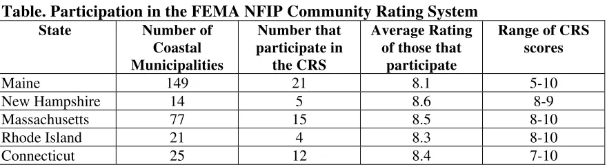
The NFIP offers towns the opportunity to reduce insurance premium rates if they participate in the Community Rating System (CRS). There are several planning and mitigation actions that a community can do to reduce the rates. Most towns either have not participated or have participated minimally in the program.
Table. Participation in the FEMA NFIP Community Rating System
State Number of
There is adequate capacity across the region to develop basic hazard plans, though resources are requested for specialists to assist with more rigorous comprehensive planning approaches to incorporate smart growth concepts (Massachusetts Coastal Hazards Commission 2007) that increase resilience. The greatest capacity gap is in the implementation of the plans’ preparedness and mitigation actions. There appears to be a gap in political commitment and funding to implement most actions.
A few priority planning and regulatory needs are shared across most of the region. Because the Northeast is a home-rule government, increased coordination between local jurisdictions could improve coastal protection and stakeholder understanding. New Hampshire’s state hazard plan is a guide for local governments; however, each jurisdiction can develop distinct permitting programs and mitigation strategies
(Southwest Region Planning Commission 2002). Towns in the Connecticut River estuary area used a uniform approach to prepare their hazard plans. This has resulted in
consistency with federal standards and integrated mitigation strategies across jurisdictions but within the same ecosystem.
Mitigation
Each state and local (county or town) government should have by now a hazard mitigation plan to meet federal requirements for funding and disaster assistance. This push toward pre-disaster mitigation planning and actions was a result from the impacts of Hurricane Andrew in 1992. Mitigation is now a prominent concept in the emergency and coastal management communities, as opposed to waiting for post-disaster funding and assistance (Pogue and Lewis 1999). However, obstacles remain and are common across the region. Perhaps the greatest challenge is the complacency of the public and to some extent government officials, since the region has not experienced a major disaster since the 1950s (SNENYOCWG 2007). Combined with this complacency is a strong
preference to rely on post-storm emergency funding (Robadue 2007). This has resulted in many mitigation plans developed without much implementation to reduce risks. It is also difficult for many of these governments to commit local funding toward mitigation actions.
The mitigation plans are for the most part relatively new, although state coastal programs such as Rhode Island have had extensive policies in place—including construction standards, setbacks, and protection of coastal features such as beaches, dunes, and bluffs—and some coastal communities in other states have been enforcing similar rules for many years. Even though storm frequency is low compared to the Gulf coast and southeastern Atlantic states, the stock of buildings constructed before any regulatory standards is high, the power of past storms has been devastating, and participation in flood insurance programs in the region is surprisingly low.
While it is challenging to find status updates on mitigation actions or evidence of savings from most of the mitigation plans, there are a few case studies that highlight the long-term cost benefits. Before the current emphasis on soft engineering structures, there were many hard shore protection projects, such as hurricane barriers, sea walls, and harbor protection, that have over the past couple of decades provided a return on investment. For example, in Connecticut, the Pawcatuck-Stonington Hurricane Protection Project, built in 1963 at a cost of $920,000, is considered a success in protecting a 31-acre industrial site. The Stamford Hurricane Protection Barrier, built in 1969 at a cost of $14.5 million, is reported to have prevented damages of $28 million to date. The New Bedford-Fair Haven-Acushnet hurricane protection project, built in 1966 at a cost of $18.6 million, has to date prevented an estimated $18.8 million in damages. The town of Westport,
Connecticut, undertook a program beginning in 1993 to elevate 22 homes and installed evacuation signs in a project costing $1.33 million. Damage avoided in subsequent storms was estimated to provide a total mitigation benefit by the end of the decade of $ 4.78 million for a Benefit/Cost Ratio of 3.58 (Association of State Flood Plain Managers 2000). More resources and management commitment are needed for post-storm data to measure success or failure of mitigation actions. To aid in that assessment, the