Journal of Physics: Conference Series
PAPER • OPEN ACCESS
Application of geothermal physics to support geotourism development in Maluku Province
To cite this article: M Souisa and S M Sapulete 2021 J. Phys.: Conf. Ser. 1816 012002
View the article online for updates and enhancements.
You may also like
Who gets the benefits of geopark establishment? A study of Batur Geopark Area, Bali Province, Indonesia
S Sagala, A Rosyidie, M A Sasongko et al.
-
Implementation of geotourism concept in developing natural tourist attraction at parbaba village, Toba’s caldera Nurlisa Ginting and Febriandy -
The geodiversity potential of Tanah Datar District developing into a geotourism asset as a geopark in Indonesia
Osronita, Syafri Anwar, Heldi et al.
-
The 10th International Conference on Theoretical and Applied Physics (ICTAP2020) Journal of Physics: Conference Series 1816 (2021) 012002
IOP Publishing doi:10.1088/1742-6596/1816/1/012002
Application of geothermal physics to support geotourism development in Maluku Province
M Souisa1,2,3 and S M Sapulete1,2,3
1Physics Department, Faculty of Mathematics and Science, Pattimura University
2Landslides Laboratory, Faculty of Mathematics and Science, Pattimura University
3Geosciences Center & Disaster Mitigation, Faculty of Mathematics and Science, Pattimura University
E-mail: [email protected]
Abstract. This investigation aims to determine the hydrophysical gradient and the distribution of shallow surface geothermal manifestations. Geothermal manifestation data acquisition using the hydrophysical method. The manifestation of surface geothermal at the research location is only used by the local community as a place for bathing, and there is no accurate data regarding the potential of geothermal so that it can be used as a development of tourist objects (geotourism). The results showed the distribution of temperature and conductivity of surface hot springs based on hot springs around geothermal energy, consisting of two locations, namely the locations of Tulehu Village, Salahutu Subdistrict, and Nalahia Village, Nusalaut Subdistrict. The Tulehu Village location consists of two loci that are the Hatuasa locus with surface temperature values ranging from (60.1 - 80.9) oC and conductivity values ranging from (0.69 - 0.95) W/m. oC, and Talanghaha locus locations surface temperature values range from (65.5 - 67.5) oC, and conductivity values ranging from (0.68 - 0.78) W/m.oC. Whereas the location of Nalahia Village consists of the Bantang locus which has a surface temperature value of (50.1 - 61.9) oC, and the conductivity value is (0.51 - 0.71) W/m.oC. For this reason, the hydrothermal conditions of geothermal manifestations in the two research sites can be developed into geothermal hot water and maximum therapy to improve the economy of the local community and the development of the geotourism sector in Maluku Province.
1. Introduction
The geological arrangement in Maluku is unique because it comes from the collision of four world plates, namely the Indo-Australian plate, the Pacific plate, the Philippine sea plate, and the Eurasian plate [1,2], thus forming various kinds of landscapes. Maluku is in the ring of fire of the world, so it has a source of geothermal energy. The results of the plate collision provide a potential landscape to be used as a tourist attraction [3]. Diversification and enrichment of types of natural tourism objects based on the earth are one of the real forms of the development of the tourism industry which is based on the principle of returning to nature. Sustainable tourism development which is oriented towards improving the welfare of local communities makes geo-tourism development efforts packaged in the framework of encouraging programs to accelerate regional development with a geological perspective [4]. This is realized through the existence of hot spring reservoirs (hydrothermal) that flow to the surface of the earth in the villages of Tulehu and Nalahia which are used as study areas.
Hydrothermal systems are generally natural fractured rocks. If the geological structure allows, then the water will flow through cracks and weathered rock, and then appear on the surface. A phase change may occur on its way to the surface, that is when the air temperature has reached its saturation
The 10th International Conference on Theoretical and Applied Physics (ICTAP2020) Journal of Physics: Conference Series 1816 (2021) 012002
IOP Publishing doi:10.1088/1742-6596/1816/1/012002
or boiling temperature. When that happens, the fluid will be in the form of a water-vapor mixture or perhaps a single-phase vapor. Will causes the types of surface geothermal manifestations to be very diverse, there are hot springs or hot springs that gush to the surface to a height ranging from one meter to several tens of meters at intervals ranging from a few minutes to A few hours or several days, mud pools, hot spring pools, and other geothermal manifestations, each of which has a different effect shallow surface heat on geo-tourism of Tulehu and Nalahia hot springs.
2. Method
Research on surface geothermal manifestations with the emergence of hot spring is used as a tourist attraction for Tulehu and Nalahia hot springs is field research based on hydrophysical methods.
2.1 The temperature gradient and heat flow
In general, the basic relationship for heat transfer is by conduction. This relationship states that the rate of heat flow by conduction in a material is equal to the product of three quantities, namely the material's thermal conductivity, cross-sectional area, and temperature gradient. The temperature gradient in a cross-section shows the rate of change in temperature T for the distance or depth in the direction of heat flow z, as follows:
z T
gradient temperatur
The (1)
The factors that affect the temperature gradient are variations in thermal conductivity, which are influenced by rock composition, the position of magma fluid, groundwater circulation, the water content in rocks, production and consumption of heat in chemical reactions, and the influence of pressure and temperature on conductivity.
T
z
-DT
+Dz The heat flow direction
Figure 1. The direction of flow of heat conduction
The variation between temperature and depth can be presented in Figure 1, which shows the direction of increase in distance or depth (z) is the direction of positive heat conduction flow. If the temperature gradient ∂T / ∂z = 1, then the amount of heat conductivity of a material is the amount of heat energy flowing in a material per unit area.
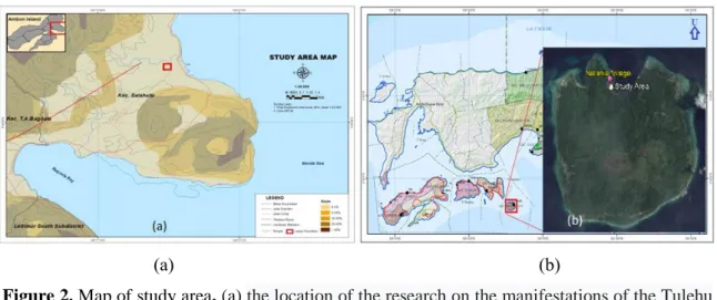
2.2 Study area
The location that becomes the research target is the area of geothermal manifestation in the Tulehu and Nalahia hot springs tourism objects. The existence of this geothermal manifestation is supported by the existence of Tulehu hot springs which are located at coordinates 3°38'2.80"South Latitude and 128°20'10.03" East Longitude (Figure 1.a), as well as Nalahia hot springs located at coordinates 3039.286 South Latitude–128046.852 and 3038.714 South Latitude–128046.621 East Longitude
The 10th International Conference on Theoretical and Applied Physics (ICTAP2020) Journal of Physics: Conference Series 1816 (2021) 012002
IOP Publishing doi:10.1088/1742-6596/1816/1/012002
(Figure 1.b). Geologically, the study area is located on the volcanic rock of the Ambon volcanic unit [5], around the coastline, alluvium is found consisting of volcanic clastics mixed with coral reefs [6].
(a) (b)
Figure 2. Map of study area, (a) the location of the research on the manifestations of the Tulehu surface hot spring, (b) location of research on the manifestation of surface hot spring in Nalahia
2.3 Data acquisition
Study of geothermal manifestations on the surface as evidenced by the emergence of hot spring at the research location which is used as a hot spring tourist attraction. The instruments used in data acquisition were the digital thermometer, conductivity meter, salt meter, pH meter, and GPS. Field survey activities began with hydrophysical data collection in the form of temperature and conductivity at each depth, heat flow rate, salinity, and pH. At each measurement point, the hydrophysical parameters are measured using GPS coordinates. Then in each hot spring, a 1-liter water sample was taken and put into the sample bottle.
2.4 Field data processing
Based on the data obtained from the field acquisition, it is used to determine the temperature gradient, conductivity, and salt content which is processed in the form of a hydrophysical gradient graph using the depth function in the hot springs area. Meanwhile, iso-hydrophysical two-dimensional (2-D) cross- sectional modeling is expressed in terms of isothermal and iso-conductivity. Analysis of water samples is carried out in the laboratory to determine physical, chemical, and microbiological parameters.
3 Results and Discussion
The research results shown in this section include temperature and conductivity gradients in surface hot spring geo-tourism and hot spring quality in the study area. The results of this research provide an overview of the application of hydrothermal physics to explain the process of movement of shallow surface geothermal manifestations.
3.1 Temperature and conductivity gradient on surface hot spring geo-tourism
Based on field observations, it was found that geothermal manifestations were found in the form of two hot springs that appeared in gas bubbles that became hot springs geo-tourism, namely Tulehu and Nalahia hot springs. Both of these geo-tourism utilize the air that comes out of the ground and rocks.
To see the distribution of gradients temperature measurements is taken directly. This measurement is carried out in cloudy weather and does not use environmental controls such as measurement, pressure, and temperature.
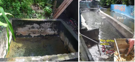
3.1.1 Temperature gradient on Hatuasa hot springs geo-tourism. The Hatuasa location has two hot springs which are used as geo-tourism (Figure 3), namely a hot spring reservoir with an area (2.50
The 10th International Conference on Theoretical and Applied Physics (ICTAP2020) Journal of Physics: Conference Series 1816 (2021) 012002
IOP Publishing doi:10.1088/1742-6596/1816/1/012002
3.54) m2 with a depth of ± 1.71 m. This well is open, the color of the water on the surface of the well is colorless (clear) and slightly salty with an average salinity level of 0.12%. While the bottom part is brown because it contains alkaline chlorides which precipitate [7, 8, 9] and also contains anions and cations in it [10]. Besides, there are 2 Hatuasa hot spring storage pools, namely the first pool close to the hot spring in the form of gas steam which has an area (15.17 3.36) m2 and the second pool is adjacent to the first pool which has an area (25.60 3.33) m2. The color of the water in the two pools was colorless, and the spring in the first pool was slightly salty with an average salinity level of 0.03%.
(a) (b)
Figure 3. Hatuasa hot springs geotourism. (a) Hot spring reservoirs and (b) Hatuasa hot spring reservoirs
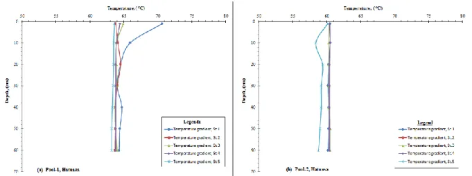
Shallow surface temperature measurements were carried out directly at a depth of 1.0 cm to 60.0 cm with 10 cm intervals (Figure 4). The temperature acquisition was carried out for 3 hot spring reservoirs in the Hatuasa hot spring geo-tourism area as follows:
1) The results of temperature measurement at the Hatuasa hot spring well ranged from (80.7 - 81.7)
OC.
2) Measurement of temperature in the first Hatuasa hot spring pool is divided into 5 stations with a distance of 2.0 m for each station. The results of temperature measurements at each depth station ranged from (63.2 - 70.6) OC.
3) Measurement of temperature in the first Hatuasa hot spring pool is divided into 5 stations with a distance of 2.0 m for each station. The results of temperature measurements at each depth station ranged from (58.8 - 60.5) OC.
In the first pool of hot springs (Figure 4), the temperature gradient value varies with depth with the highest temperature gradient of 70.6 OC / cm at a depth of 1.0 cm near hot springs (Figure 4a) while the lowest temperature gradient is 1.05 OC / cm located at a depth of 60.0 cm, which is 11.0 m from a hot spring. Significant temperature gradient changes with depth are found in hot spring reservoirs.
Whereas in hot spring storage ponds, the temperature gradient is almost linear with depth or does not change significantly with depth except for pool-1 station 1 and pool-2 station 2. This less significant change is because the hot spring temperature conditions in the pond are maintained. stable by increasing or decreasing the intake of water sourced from rivers and from water tanks supplied to pool with ambient temperature (25.0 - 26.5) OC to be mixed with hot springs at temperatures above 70.6 0C. Mixing the water collected in the pool is carried out, aiming to reduce the temperature of the water
The 10th International Conference on Theoretical and Applied Physics (ICTAP2020) Journal of Physics: Conference Series 1816 (2021) 012002
IOP Publishing doi:10.1088/1742-6596/1816/1/012002
so that it can be used for body recoveries such as bathing and therapy. Cleaning the hot spring storage pool is carried out every 3 days using an open irrigation system.
(a) (b)
(c)
Figure 4. Hatuasa hot spring temperature profile. (a) Hot spring temperature gradient Hatuasa pool-1, (b) Hot spring temperature gradient Hatuasa pool-2, and (c) Hot spring temperature gradient at Hatuasa well
3.1.2 Temperature gradient at Talanghaha hot spring geo-tourism. Geo-tourism of Talanghaha hot spring found one hot spring that appeared in the form of gas bubbles collected in a hot spring reservoir with a diameter of 1.7 m with a depth of hot spring 15.0 cm, a little salty taste with an average salinity level of 0.17%, green color due to a large number of algae and this well is slightly closed.
There are 3 pools of Talanghaha hot spring which are used as geo-tourism, namely the first pool close to the hot springs with an area (10.3 4.4) m2, the second pool adjacent to the first pool has an area (10.3 5.4) m2, and the third pool adjacent to the pool second with an area (10.3 4.4) m2. The watercolor in the three ponds was found to be colorless and slightly salty with an average salinity level of 0.03%.
The 10th International Conference on Theoretical and Applied Physics (ICTAP2020) Journal of Physics: Conference Series 1816 (2021) 012002
IOP Publishing doi:10.1088/1742-6596/1816/1/012002
(a) (b)
Figure 5. Talanghaha hot spring geo-tourism. (a) Storage wells for hot springs and (b) reservoirs for hot spring
Shallow surface temperature measurements were carried out directly at a depth (1.0 - 60.0) cm with 10 cm intervals (Figure 6). The temperature acquisition was carried out for 3 hot spring reservoirs in the Talanghaha hot spring geo-tourism area as follows:
1) Talanghaha hot spring well has a measured temperature of 80.2 OC.
2) Measurement of temperature in the first pool of Talanghaha hot spring is divided into 5 stations with a distance of 2.0 m for each station. The results of temperature measurements at each depth station ranged from (65.6 - 66.9) OC.
3) Measurement of temperature in the first pool of Talanghaha hot spring is divided into 6 stations with a distance of 2.0 m for each station. The results of temperature measurements at each depth station ranged from (66.7 - 67.5) OC.
4) Measurement of temperature in the first pool of Talanghaha hot spring is divided into 5 stations with a distance of 2.0 m for each station. The results of temperature measurements at each depth station ranged from (66.4 - 70.5) OC.
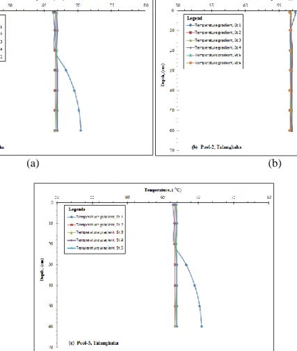
In the first pool of hot springs (Figure 6), the temperature gradient varies with depth, with the highest temperature gradient of 66.9 OC/cm at a depth of 1.0 cm near the hot springs (Figure 6a), while the lowest temperature gradient is 1.1OC/cm at a depth of 60.0 cm away from a hot spring 2.2 m. In the second pool of hot spring storage, the temperature gradient value varies with depth, with the highest temperature gradient of 66.8 OC/cm and 6.05 OC/cm at a depth of 1.0 cm, a distance from the hot spring 5.5 m (Figure 6b), while the temperature gradient the lowest is 1.11OC/cm at a depth of 60.0 cm, a distance of 5.5 m from a hot spring. For the third hot spring reservoir, the temperature gradient value varies with depth, with the highest temperature gradient of 66.9 OC/cm at a depth of 1.0 cm located near hot springs with a distance of 9.5 m (Figure 6c), while the lowest temperature gradient of 1.11 OC/cm, at a depth of 60.0 cm, a distance of 9.5 m from a hot spring.
The 10th International Conference on Theoretical and Applied Physics (ICTAP2020) Journal of Physics: Conference Series 1816 (2021) 012002
IOP Publishing doi:10.1088/1742-6596/1816/1/012002
(a) (b)
(c)
Figure 6. Hot spring temperature gradient profile. (a) The gradient of hot spring temperature in the pool-1 Talanghaha, (b) The gradient of the temperature of the hot spring in the pool-2 Talanghaha, and (c) the gradient of the temperature of the hot spring in the pool-3 Talanghaha
Based on the temperature gradient, it shows that in hot water reservoirs, the temperature gradient is almost linear with depth or does not change significantly with depth, except in pool-1 station 1 and pool-3 station 2. This less significant change is due to the fact that the hot spring temperature conditions in the pool are maintained stable by adding or reducing the intake of low-temperature water from a water storage tank that is supplied to the pool with ambient temperature (25.0 - 26.5) OC to be mixed with hot spring sources with a temperature above 80.2 0C. Mixing the water collected in the pool is carried out, aiming to reduce the temperature of the water so that it can be used for body recoveries such as bathing and therapy. Cleaning the hot spring storage pool is carried out every 3 days using an open irrigation system like the Hatuasa geo-tourism.
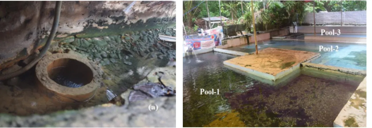
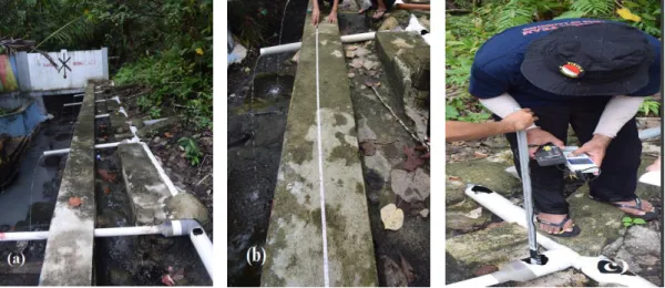
The results of data acquisition are in the form of temperature, depth, and coordinate tie points that are focused on the Bantang hot spring source area. The total data acquisition area covers 23.0 x 17.0 m2. The area is narrow, because Bantang's hot spring is still blocked by sago palms that grow mixed with other large trees, and are inundated by hot mud, so it is necessary to be careful in carrying out data acquisition. Based on field observations, there were two hot springs that appeared in the gas bubbles which were used as hot spring geo-tourism, namely hot springs that came out of the river border and came out of the hot mud that was inundated. The source of hot spring from the hot mud that appears macroscopically appears in the form of gas bubbles with less sulfur content and moves
The 10th International Conference on Theoretical and Applied Physics (ICTAP2020) Journal of Physics: Conference Series 1816 (2021) 012002
IOP Publishing doi:10.1088/1742-6596/1816/1/012002
out of the surface through the mud (hot spring mixes with rotting soil and trees). The color of the water on the surface is colorless (clear) and slightly salty with an average salinity level of 0.51 ‰, while the bottom part is green with lots of algae that thrive. The movement of surface hot spring originating from hot mud is accommodated by a small trap system, then flowed through 5 pipelines (Figure 7). The mean distance between the pipes is 2.5 m. Hot water that flows through pipes with an average measured discharge value of 0.22 m3/s and is slightly salty with an average salinity level of 0.34 ‰. Irrigation of hot water through pipes is allowed to fall freely by the influence of the earth's gravity and is used by local people or users of hot water attractions for bathing as well as therapy.
Then for the second hot spring, it emerges from the surface of the Bantang river wall, and the heat mixes with river water. This hot spring is a colorless and slightly salty taste with an average salinity level of 0.31 ‰.
(a) (b) (c)
Figure 7. Bantang Nalahia hot spring geo-tourism. (a) 5 hot spring pipelines, (b) measuring the distance of each pipeline, and (c) measuring hot spring parameters
Shallow surface temperature measurements are carried out directly at certain measuring points with depth (1.0 - 20.0) cm with intervals of 5 cm. Acquisition of surface physical parameters is carried out at 3 measuring points, with each measuring point divided into several stations according to the length of the locus. Furthermore, 1 measuring point is taken according to the water depth to measure temperature and conductivity to depth. From each measuring point, the hydrothermal parameter values obtained in the Bantang hot spring geo-tourism area are as follows:
1) The first measuring point on the river border, the 1.5 m length of the track is divided into 4 stations with a distance of 0.35 m, the results of the temperature measurement according to the direction of the river flow range from (50.1 - 61.4) OC, the conductivity values range from (0.52 - 0.68) W/m.0C, the salinity value is between (0.01 - 0.12) ‰, the pH value is 7.1, and the average discharge value is 0.42 m3/s.
2) The second measuring point in the hot mud, the measurement is divided into 2 stations with a distance of 3 m, has a temperature ranging from (61.7 - 61.9) OC, conductivity is between (0.69 - 0.71) W/m.0C, the salinity of 0.51 ‰ and a pH of 7.3.
3) The third measuring point in the irrigation pipeline, the distance between the 2.2 m pipes are divided into 6 stations (according to the hot water irrigation pipeline), has a temperature value ranging from (57.1 - 61.5 OC), the conductivity value ranges from (0.63 - 0.70) W/m.0C, the salinity value is between (0.31 - 0.37) ‰, the pH value is 7.2, and the average discharge value is 0.21 m3/s.
The 10th International Conference on Theoretical and Applied Physics (ICTAP2020) Journal of Physics: Conference Series 1816 (2021) 012002
IOP Publishing doi:10.1088/1742-6596/1816/1/012002
4) The pool at the first measuring point, measured at each depth starting from 1.0 cm - 20.0 cm with an interval of 5.0 cm. The measurement results starting from the depth of the surface to the bottom of the obtained temperature range is (57.4 - 69.5) OC, the range of conductivity values is (0.62 - 0.78) W/m.0C, the range of salinity values is (0.08 - 0.50) ‰, and the range pH value is 7.1 - 7.5.
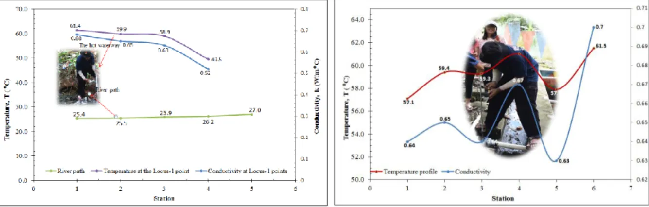
Based on these data, a temperature and conductivity profile can be described at each measuring point, as well as a temperature gradient and conductivity of shallow surface hot spring, as shown in Figures 8 and 9. The increase in temperature and conductivity can be seen in the discharge of hot spring in the form of gas bubbles or close to hot springs on the surface of the measuring point with a temperature value of up to 61.9 OC and a conductivity value of 0.71 W/m.0C, then at the base of the measuring point, the temperature value reaches 61.5 OC and a conductivity value of 0.70 W/m.0C. The decrease in temperature at the measuring point is due to the fact that at each measuring point on the river border, the flow of hot spring coming out of the source has mixed with surface river water with an average temperature of 26.0 OC. The presence of hot mud is caused by mixing water with rotting plants and weathering of soil-rock material. Thus, the temperature of hot spring at each measuring point is higher than 50 OC and is categorized as a manifestation of surface hot spring or hot spring that appears to the surface.
Figure 8. Temperature profile and surface hot spring conductivity in the Bantang river route
Figure 9. Temperature profile and surface hot spring conductivity in Bantang pipeline
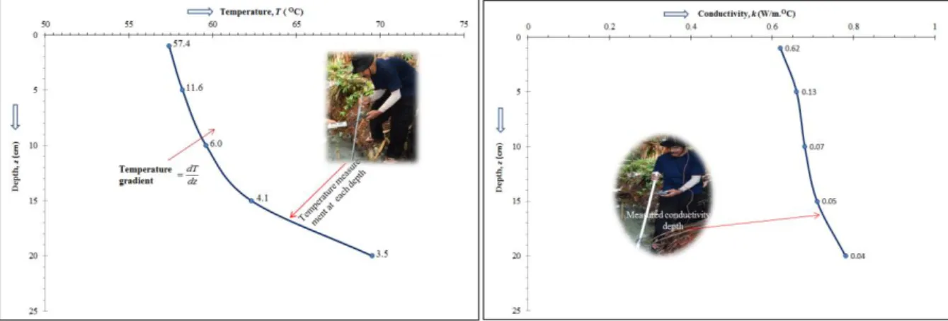
At the first measuring point, the hot springs have mixed with river water flowing on the surface, having temperature gradient values and conductivity varying with depth (Figure 10 and Figure 11).
The highest temperature and conductivity gradient values were 57.4 OC/cm and 0.62 W/m.0C/cm at a depth of 1.0 cm, while the lowest temperature and conductivity gradients were 3.5 OC/cm and 0.04 W/m.0C/cm at a depth of 20.0 cm. Temperature and conductivity change according to changes in the depth of the hot spring pool, where the deeper the pool the temperature and conductivity gradient decreases. The greater the thermal conductivity, the greater the heat flow, where the thermal conductivity flows automatically from a point with a higher temperature to a point with a lower temperature. Thermal conductivity is influenced by temperature and pressure which will increase at a certain depth.
The 10th International Conference on Theoretical and Applied Physics (ICTAP2020) Journal of Physics: Conference Series 1816 (2021) 012002
IOP Publishing doi:10.1088/1742-6596/1816/1/012002
Figure 10. Temperature gradient profile and conductivity of shallow surface hot spring in the Bantang river route
3.2 Hot spring temperature and conductivity modeling
The effect of temperature and pressure will change the conductivity of the porous fluid [11]. Fluid conductivity, porosity, permeability, and saturation can change significantly in volcanic processes.
Porosity can also be reduced by the formation of alteration minerals chemically so that it is suitable as a source of geothermal energy, while high porosity with reservoir rocks has a lot of water content so it is not suitable as a source of geothermal energy [12]. Permeability is an important parameter to determine the velocity of fluid flow in porous and natural fractured rocks [13]. In general, the thermal conductivity of geothermal rocks is influenced by several factors, namely the existing geological structures in the field such as normal faults and lineaments, the presence of alterations, and the type of manifestation of geothermal water in the form of fumaroles [14]. In a volcanic system, conductivity will increase when near the magma area [15], fluid is mineralized into or accumulates in porous rock.
3.2.1 Modeling of temperature and conductivity of Tulehu hot water. The results of the modeling of temperature distribution and shallow surface conductivity in the study area are shown in an isothermal map as shown in Figure 11. The distribution of geothermal temperature in the study area is more concentrated from the south to the northeast and continuously to the north. This is indicated by the emergence of surface geothermal manifestations in the form of gas bubbles emerging from the river wall avalanches flowing out in the form of hot springs, as has been stated by [16]. In general, the geothermal manifestations in Hatuasa and Talanghaha are along fault lines, particularly the Banda fault and the Banda-Hatuasa fault [17] which are closely related to geothermal anomalies. If viewed from the regional geological map of Ambon Island, the geothermal area of Tulehu is dominated by Ambon volcanic rocks, dominated by andesite lava, dacite, and breccia [18].
The results of field observations show that the geothermal manifestations at 2 locations (Hatuasa, Talanghaha) are categorized as hot springs and there are also fumaroles as has been stated by Vandani [19], and there are alteration rocks that are related to the Banda fault. The emergence of geothermal energy is the result of the interaction of igneous rock (andesite) with hot fluids containing metals, and this results in hydrothermal alteration. The fluid that appears has a small hot spring discharge (Hatuasa hot spring is 0.67 m3/s and alternative hot spring is 0.57 m3/s), possibly due to less large permeability near the surface or the interaction of hot fluids with andesitic rocks in the subsurface is not very big.
The 10th International Conference on Theoretical and Applied Physics (ICTAP2020) Journal of Physics: Conference Series 1816 (2021) 012002
IOP Publishing doi:10.1088/1742-6596/1816/1/012002
Figure 11. Iso-thermal and iso-conductivity map of shallow surface hot springs at Tulehu.
From the iso-conductivity graphs, it can be seen that there is a fairly large fluid conductivity anomaly in the valley in the hot springs at the foot of the slopes of Hatuasa and Talanghaha. On the side of the slope, river water flows, precisely along the river wall with a conductivity of 0.83 W/m.OC, while the surrounding area is only (0.55 - 0.58) W/m.OC. High conductivity values are in the vicinity of the source or where hot steam escapes from the hot springs. This is due to the water vapor content in the hot springs so that it adds to the value of its conductivity. Besides, the soil material is rock weathering which undergoes a continuous alteration process.
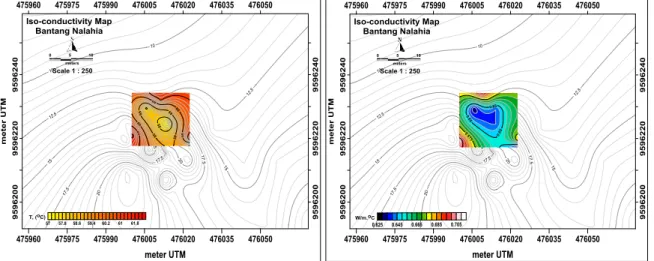
3.2.2 Modeling of temperature and conductivity of Nalahia hot springs. The distribution of geothermal temperature in Bantang Nalahia hot springs is more concentrated from the northeast to the southwest and continuously to the south. This is indicated by the emergence of surface geothermal manifestations in the form of gas bubbles emerging from river boundaries and coral rocks whose axis flows out in the form of hot spring. The appearance of this geothermal manifestation is closely related to geological conditions, especially the existence of fault structures that are abundant in the hills around the position of the measurement location.
Figure 12. Iso-thermal and iso-conductivity map of shallow surface hot springs in Nalahia
The 10th International Conference on Theoretical and Applied Physics (ICTAP2020) Journal of Physics: Conference Series 1816 (2021) 012002
IOP Publishing doi:10.1088/1742-6596/1816/1/012002
From the isothermal graphs, it can be seen that there is a large heat anomaly at the border or gap in the Bantang river. The geothermal cross-sectional map describes the geothermal manifestations that appear on the surface in the form of the hot air which has high temperatures spreading to the southwest to the northeast. The appearance of geothermal manifestations in the study area is closely related to geological conditions, especially the existence of fault structures that are abundant in the hills around the measurement. Based on a regional geological map of the Seram Nusalaut peninsula, the geothermal area of Nalahia is dominated by volcanic rocks in the form of andesite lava, dacite, and breccias.
Field observations show that the geothermal manifestation in Bantang Nalahia is categorized as hot springs and there is also fumarole, and there is alteration rock that is related to the Banda-Nusalaut fault. The existence of hot springs and fumaroles due to the passage of hot steam from below the surface to the top of the earth's surface has gone through several stages so that it reaches the surface where hot steam has decreased and the sulfur has decreased, so hot spring is more dominant. The steam that passes through the rock moves to the surface heating the rock and on its way it mixes with the water flow so that the water becomes hot and comes to the surface. The emergence of geothermal energy is the result of the interaction of igneous rock (andesite) with hot fluids containing metals and this results in hydrothermal alteration. The fluid that appears has a Bantang hot spring discharge of up to 0.42 m3/s, possibly due to the less large permeability near the surface or the less large interaction of hot fluids with andesitic rocks below the surface.
From iso-conductivity graphs (Figure 12), it shows a fairly large fluid conductivity anomaly in hot springs that come out of the ground and from the surface of the trees around the Bantang river. The distribution of geothermal sources near the surface in Bantang geo-tourism has increased temperature and conductivity to the east-southeast. It is found on the side of the slope flowing river water, precisely along the river wall with conductivity reaching 0.71 W/m.OC, while the surrounding area only ranges (0.52 - 0.68) W/m.OC. High conductivity values are in the vicinity of the source or where hot steam escapes from the hot springs. This is because the water vapor content in the hot springs will add to its conductivity value. Besides, the soil material is rock weathering which undergoes a continuous alteration process. It should be explained here that the measurement is carried out only on the conductivity of water, not rock because the conductivity of water and rock is different. Rocks that have not experienced weathering or are compact/solid have low conductivity, on the other hand, rocks that have experienced weathering have high conductivity.
3.3. Hot spring quality in the study area
The results of measurement of Dissolved Residue (TDS) parameters in water samples for Tulehu hot spring are 980 mg / L and Nalahia 1052 mg / L. The total value of dissolved solids of water quality in geo-tourism of hot spring in Nalahia is already above the required quality standard, while in Tulehu it is below the permissible level. This is in accordance with the standards set by the Regulation of the Minister of Health of the Republic of Indonesia Number 32 of 2017 [20]. The total value of dissolved solids obtained in this analysis was higher than the value of total suspended solids. This illustrates that the solids that enter the water body are mostly in the form of small solids (dissolved solids) or solids in the water bodies are dominated by solids originating from organic wastes.
The results of measurement and analysis of physical, chemical, and microbiological parameters in air samples (Table 1) from Bantang Nalahia hot springs show that the total solids, cadmium, hardness, and even chloride and coliform values have exceeded the required quality standard. Meanwhile, in Tulehu, the elements of cadmium, hardness, and chloride had exceeded the required quality standard threshold. The concentration of chloride (Cl) in groundwater is greater and tastes salty with the amount of solute (TDS) exceeding the permissible standards, meaning that there is a chloride anomaly and an anomaly of groundwater conductivity that exceeds the standard, so Bantang Nalahia hot spring has been polluted due to the intrusion process of seawater. Groundwater contamination by seawater intrusion is thought that Bantang hot water has a flat surface with a height of up to (5 - 10) m.dpl, while for soil types it belongs to the Alluvial and Coluvial association groups. In Tulehu and Nalahia
The 10th International Conference on Theoretical and Applied Physics (ICTAP2020) Journal of Physics: Conference Series 1816 (2021) 012002
IOP Publishing doi:10.1088/1742-6596/1816/1/012002
hot springs, there are pollutants in the surface soil water layer mixed with hot steam that cannot be consumed daily as clean water. The condition of hot spring in Nalahia affects groundwater that has been contaminated or intrusive with leachate from seepage of garbage and seepage of rotten trees that can contaminate surface water.
Tabel 1. The results of testing groundwater samples against the test samples that are not in accordance with the permissible levels
Parameters Permissible
levels Units Sample test results
Tulehu Nalahia
Physical
Amount of solute, (TDS) 1000 mg/L 980 1052
Taste Tasteless Salty Salty
Chemical
Cadmium 0.005 mg/L 0.011 0.022
Hardness 500 mg/L 1150 8200
Microbiological
Chloride 250 mg/L 1320 3660
Total coliform 50 cfu/100 ml 42 438
In the study area, there is the movement of leachate in the soil from rotting trees so that the cadmium parameters are below the water quality standard requirements. According to the results of the analysis, it can be seen that the high content of pollutant elements from leachate and decomposition of leachate on decomposing materials, and greatly affects the quality of hot water around. This is indicated by the water quality parameters that have exceeded the water quality standard.
Geothermal manifestations are characterized by the appearance of hot spring on the surface at the Bantang hot spring geo-tourism location, resulting in a lack of soil ability to absorb water imperfectly so that coliform bacteria can contaminate water sources. The water used for washing and bathing by local residents has the potential to be contaminated by coliform bacteria. The cause of contamination of clean water is from a water source close to an unclean environment, such as close to a laundry waste disposal site and close to hot mud, so that it can be contaminated by coliform bacteria. Coliform bacteria are a group of microorganisms that are commonly used as indicators where these bacteria can be a signal to determine a water source that has been contaminated by pathogens or not. Based on research, these coliform bacteria produce ethionine which can cause cancer.
In supporting the development of sustainable Tulehu and Nalahia hot springs geo-tourism to boost tourism, serious attention is needed to environmental cleanliness by local communities and stakeholders, and more specifically, a system for capturing and controlling hot spring from surface geothermal manifestations into reservoirs is needed.
4 Conclusion
The gradient of temperature and conductivity of hot spring in the vicinity of geothermal manifestations has been determined in three hot spring geo-tourism locations, namely Tulehu (Hatuasa and Talanghaha), and Bantang (Nalahia). The geothermal isothermal pattern based on hot springs around the geothermal manifestation is divided into three locations, namely the Hatuasa location has a surface temperature value ranging from (60.1 - 80.9) OC, the Talanghaha location a surface temperature value ranging from (65.5 - 67.5) OC, and Bantang Nalahia location has a range of surface temperature values (50.1 - 61.9) OC. The temperature distribution at these three locations is more concentrated from the south to the north and continue to the northeast. Iso-conductivity patterns around shallow surface geothermal manifestations are divided into three, namely the Hatuasa location with a surface conductivity value (0.69 - 0.95) W/m.OC, the Talanghaha location with a surface conductivity value (0.68 - 0.78) W/m.OC, and Bantang location with surface conductivity values (0.51 - 0.71) W/m.OC.
The 10th International Conference on Theoretical and Applied Physics (ICTAP2020) Journal of Physics: Conference Series 1816 (2021) 012002
IOP Publishing doi:10.1088/1742-6596/1816/1/012002
The distribution of shallow surface hot spring conductivity at the three locations is concentrated from the south to the north and continue to the northeast. Testing of hot spring samples has been carried out in the laboratory and correlated with the results of hydrophysical measurements showing that there is a seawater intrusion zone in the Bantang Nalahia hot spring pool and it is estimated that it is connected to the lowlands so that it has implications for the magnitude of potential contamination by leachate in the geothermal manifestation column surface. The results of the physical analysis of surface geothermal manifestations in the research area can be used to support the development of hot springs geo-tourism, especially as a health therapy.
Acknowledgments
The author would like to thank to Headman of Tulehu and Nalahia who gave permission to research.
Thanks are also to the Geoscience Laboratory of the Department of Physics, Faculty of Mathematics anda Natural Science, Pattimura University, which has prepared equipment for field data acquisition, and students who have helped in the data acquisition process.
References
[1] Groen E T and Jacobs C 2012 Risk mapping Indonesia (Sector Disaster Risk Reduction and Emergency Aid Cordaid) p 1-11
[2] Van Bemmelen R W 1949 The geology of Indonesia (Government Printing Office, Matinus Nijhoff, The Hague I(A)) p 52-53
[3] Katili J A 1989 Review of past and present geotectonic concepts of Eastern Indonesia Netherland Journal of Sea Research, Elsevier Science B V 24(2) p 103-129
[4] Hermawan H 2017 Geowisata: Pengembangan Parawisata Berbasis Konservasi (Sekolah Tinggi Pariwisata AMPTA Yogyakarta) p 49-62
[5] Tjokrosapoetro E, Rusmana E and Achdan A 1994 Geological Map of the Ambon Sheet Maluku, Direktorat Jenderal Geologi dan Sumberdaya Mineral (Pusat Penelitian dan Pengembangan Geologi Bandung) p 3-11
[6] Hehanusa P E, Sule A and Alot R 1987 Penelitian Air Tanah di Nusalaut Maluku Tengah (Geoteknologi LIPI Bandung)
[7] Izquierdo G, Arellano V M, Aragón A, Portugal E and Martínez I 2000 Fluid Acidity and Hydrothermal Alteration at the Los Humeros Geothermal Reservoir Puebla Mexico Proceedings World Geothermal Congress 2000 Kyushu - Tohoku Japan p 1301-1306
[8] Sari A W I, Vandani C P K, Mulyaningsih E, Warmada W I, Utami P and Yunis Y 2014 Studi alterasi hidrotermal bawah permukaan lapangan panas bumi “BETA”, Ambon dengan metode X-ray Diffraction Prosiding Seminar Nasional Kebumian Ke-7 Yogyakarta Indonesia p 30-31
[9] Ármannsson H and Fridriksson T 2014 Application of Geochemical Methods In Geothermal Exploration (UNU-GTP and LaGeo, in Ahuachapan and Santa Tecla, El Salvador 17-30 October, 2009) p 1-12
[10] Óskarsson F and Ármannsson H 2015 Geochemical Methods in Geothermal Surface Exploration, Presented at Short Course X on Exploration for Geothermal Resources (organized by UNU-GTP, GDC and KenGen, at Lake Bogoria and Lake Naivasha Kenya) p 11
[11] Schon J H 1998 Physical Properties of Rock: Fundamental and Principles of Petrophysics (Pergamon Leoben)
[12] Suparno S 2009 A present from the heart of the earth Jurnal edisi pertama. Universitas Indonesia Depok Jakarta p 2-4
[13] Lagat J, Arnorsson S and Franzson H 2005 Geology, Hydrothermal Alteration and Fluid Inclusion Studies of Olkaria Domes Geothermal Field, Kenya Proceedings World Geothermal Congress 2005 Antalya, Turkey p 12-13
[14] Wohletz K and Heiken G 1992 Volcanology and Geothermal Energy (Berkeley: University of
The 10th International Conference on Theoretical and Applied Physics (ICTAP2020) Journal of Physics: Conference Series 1816 (2021) 012002
IOP Publishing doi:10.1088/1742-6596/1816/1/012002
California Press) p 120-130
[15] Lenat J F 1995 Resistivity in Volcanic Regions (http://ghp712.geo.unileipzig.
de/~geosf/research/ ERT/volcres.html) accessed 28th June 2020
[16] Lewerissa R, Sismanto, Setiawan A, Pramujoyo S and Lapono L 2020 Integration of gravity and magnetic inversion for geothermal system evaluation in Suli and Tulehu, Ambon, eastern Indonesia Arabian Journal of Geosciences DOI: 10. 1007/s12517-020-05735-7, Corpus ID:
220732330
[17] Lewerissa R, Sismanto, Setiawan A and Pramumijoyo S 2018 The Study of Geological Structures in Suli and Tulehu Geothermal Regions (Ambon, Indonesia) Based on Gravity Gradient Tensor Data Simulation and Analytic Signal Geosciences 8(4) 1-21
[18] Souisa M, Hendrajaya L and Handayani G 2016 Landslide Hazard and Risk Assessment for Ambon City Using Landslide Inventory and Geographic Information System Journal of Physics: Conference Series 739 p 1-11
[19] Vandani C P K, Sari I W A, Mulyaningsih E, Utami P and Yunis Y 2014 Studi Alterasi Hidrotermal Bawah Permukaan di Lapangan Panas Bumi “Beta”, Ambon Dengan Metode Petrografi Prosiding Seminar Nasional Kebumian Ke-7, Jurusan Teknik Geologi, Fakultas Teknik, Universitas Gadjah Mada Yogyakarta p 30-31
[20] Souisa M, Sapulete S M and Zainab 2019 Combination of Resistivity Data and Atomic Absorption Spectroscopy To Interpretation of Ground Water Pollution In Batu Merah Region, Ambon City International Journal Of Health Medicine And Current Research 4(02) p 1241-1247