ORIGINAL ARTICLE
Dynamics of Hydro-Meteorological Disasters: Revisiting the Mechanisms and
Drivers of Recurrent Floods and Landslides in Brunei Darussalam
1
Anthony Banyouko Ndah,
2Lalit Dagar and
3Kazimierz Becek
1,2
Universiti Brunei Darussalam,
3Wroclaw University of Technology Wroclaw, Poland.
*Corresponding Author:
Anthony Banyouko Ndah
Email: [email protected]
Received: 00/00/2016
Revised: 00/00/2016
Accepted: 00/00/2016
Abstract
This study examines the underlying forcing and drivers of floods and landslides in Brunei Darussalam using statistical and geospatial analysis for the purpose of uncovering efficient/effective management strategies and enhance predictive capabilities. It is based on the observation that although seasonal monsoons are generally predictable, intense episodic rainfall across Borneo is largely unpredictable with often dramatic consequences, presenting a real test to disaster preparedness and management in Brunei Darussalam. It is found that short term hydro-meteorological events are generally experienced in Brunei Darussalam during the N.E Monsoon season and are particularly severe in the month of January, triggering floods, flash-floods and landslides. These episodic events are generally forced by air-sea coupled interactions and tele-connections across the marginal South China Sea and adjacent seas/ocean bodies and magnified during different phases of the ENSO cycle. Long and short term dynamics of the air-sea coupled system often induce two synergistic flood-triggering mechanisms namely: intense anomalous rainfall and sea surface temperature anomalies in addition to prevailing socio-geographical/anthropogenic effects. It is therefore concluded that effective management of hydro-meteorological disasters in Brunei must be based on a thorough understanding of the underlying dynamics and mechanisms that produce anomalous rainfall and increase the potential for floods and landslides.
Keywords:
Anomalous rainfall, Floods, Landslides, Air-sea interactions, Brunei Darussalam.1. Introduction
Rain is one of the most important meteorological events vital in all spheres of human life but its frequency and magnitude may also be a very potent cause of hydro-meteorological disasters across the World. Extreme weather events are therefore receiving increasing attention in recent years (Karl and Easterling, 1999) largely because of the potential negative effects of these events on society and ecosystems in many obvious ways (e.g. floods, droughts, damaging high winds, extreme heat and cold) (Bhatla and Tripathi, 2014). The Asia-Pacific is especially recognized as the most populous and disaster-prone region in the world, exposed to a variety of hazards including floods, landslides, droughts, earthquakes, tsunamis, volcanic eruptions (UNISDR, 2013). According to the Countries Disaster Risks Assessment of December 2010, the frequencies of extreme weather events like heat waves, heavy
combined with one or more other causes, such as tropical cyclones, monsoonal rains etc (Dartmouth Flood Observatory, 2004; Global Risk Data Platform, 2014).
Fig 1: Most significant triggers of floods and landslides worldwide. Source: Dartmouth Flood Observatory, 2004.(http://www.dartmouth.edu/~floods/archiveatlas/ca use.html).
In the literature however, seasonal variability of rainfall across the globe shows varying degree of fuzziness. The intensity and frequency of extreme rainfall over the past few decades has been on the rise in some parts of the world, e.g. in Southern Africa (Mason et al., 1999) while in others, it has been declining (e.g. in India) (Dash et al., 2009); significant variability is observed across S.E Asia (Loo et al., 2015). Decadal variability of monsoon rainfall in the S.E Asia is however observed to influence the frequency and intensity of intermittent flooding of some areas during the monsoon season with serious human and material consequences (Loo et al., 2015). For these reasons, it is presently impossible to accurately predict, with traditional weather forecasting methods, for a significant period of time into the future, the next period of intense anomalous/episodic rainfall, or days that will receive significant amounts of rain over short spells. Such unpredictability associated with anomalous rainfall events is related to - as suggested by Trenberth et al. (1998) - the limited predictability of anomalous circulation and associated surface temperature and precipitation caused by the difficulty of finding a modest signal embedded in the high level of noise from natural variability.
Historically, Brunei has been perceived as one of the least vulnerable countries to natural hazards in Southeast Asia and vulnerable only to low-level hazards from earthquakes, cyclonic storms, floods, landslides, and seasonal smoke/haze resulting from forest fires in Indonesia (AIPA, 2012; Countries
Disaster Risks Assessment, 2010; ADRMI, 2010; ADB 2009). Despite its location in the heart of the Asia-Pacific region characterized as a hotspot for hydro-meteorological and other disasters, Brunei apparently remains a relatively low-level disaster country in the Southeast Asian region. However, much caution is required when considering such assertions because of the following reasons:
1. Amongst all the countries in the S.E. Asian sub-region which feature in the Disaster Risks Assessment of December 2010, as well as other global disaster databases, country level disaster data for Brunei is the least extensive and in most cases unavailable. Such limited reporting should obviously affect comparison with other countries.
2. Moreover, the comparison with other countries is relative and not absolute, and thus may promote a false sense of security. In this case, the real state and magnitude of disasters may be overlooked in the case of regional disaster strategies, initiatives and policies.
3. In addition, this may create an illusory sense of total security despite the presence of a real potential for escalation.
Thus, the lack of long-term climate data suitable for analysis of weather extremes is the single biggest obstacle to quantifying whether extreme events have changed over time and space (Easterling et al., 1999). vents=floods&lang=eng accessed in December 2014) as well as in regional disaster risk inventory reports (AIPA, 2012; Countries Disaster Risks Assessment of December 2010; ASEAN Disaster Risk Management Initiative, 2010). In this case therefore, the major source of reliable data on disaster events remains government institutional reports and newspapers articles. One of the World’s most comprehensive databases for global flood events, Dartmouth Flood Observatory has recognized this challenge and depends extensively on a wide variety of news and governmental sources for its Global Archive of Flood Events. It however notes emphatically that the quality and quantity of information available about a particular flood depends on the intensity of news coverage from
(http://www.dartmouth.edu/~floods/Archives/Archive Notes.html), which in some cases are highly censored Table 1: Disaster risk statistics of Brunei (1970-2009)
Source: Countries Disaster Risks Assessment (2010); ADRMI (2010).
and inaccurate. Consequently, despite the apparent security from natural hazards, in recent years, Brunei has been plagued by increasingly frequent flood disasters often accompanied by potentially deadly landslides, both of which have become a yearly spectacle. In Southeast Asia, between 1985 and 2003, the onset of large floods in Borneo is the month of December, on average, coinciding with the peak of the Northeast monsoon season when intense rainfall is generally experienced in the region (Dartmouth Flood Observatory, 2004). In the present study, intense anomalous rainfall which triggers floods and landslides in Brunei is therefore defined as high intensity monsoon precipitation over a short time frame (few hours) which often results in flash floods, and heavy rainfall which proceeds for longer hours and sometimes days, raising water storages gradually.
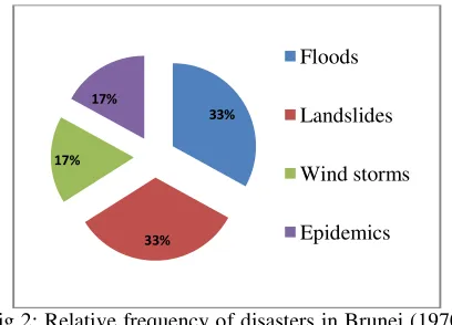
Fig 2: Relative frequency of disasters in Brunei (1970-2009) (Source: Countries Disaster Risks Assessment, 2010; ADRMI, 2010).
In Brunei, in recent years, relatively large floods have been consistent in the month of January as a result of intense anomalous daily rainfall which in most cases exceed half or even the totality of the long term average. In January 2009, flooding in Brunei caused significant damages to the infrastructure, economy as well as a case of loss of life. Over 200 houses were damaged and about 420 residents in Brunei-Muara district were among the flood victims, as well as power failures and disruption of phone services and traffic. In Seria and Kuala Belait, several schools in the low-lying
areas were closed due to continuous inundations by flood waters (NDMC, 2014). In January 2011, Belait's Bukit Sawat and in Tutong experienced severe flooding especially in the low-lying areas of these the districts. The deepest depth of flood waters at 1.6 meters, was recorded at Jalan Bengkuru in Mukim Rambai, affecting about 317 houses in Tutong District alone (Brunei Times 2011, Jan 20). In January 2014, news media and meteorological reports around Brunei Darussalam were also dominated by intense flooding and landslides, qualifying this period as one with record floods/landslides, characterized by immense social distress and suffering amongst sections of the communities. Flooding was nation-wide and especially severe in three Districts out of four, namely: Tutong, Brunei-Muara and Belait Districts. Tutong District was particularly hard-hit during the January 2014 flooding disaster. According to NDMC, flood waters rose to almost two metres affecting over 1,283 residents and badly damaging 15 homes in the District from January 01-19th, 2014. Coupled with intense flooding, landslides also made headline in the month of January, 2009, 2011 and 2014. Record landslides occurred in Brunei-Muara District; out of 154 reported cases, 21 were classified dangerous, 121 as moderate and 11 as not dangerous (Brunei Muara District Office, January 2014) (Fig 3a-c).
Most of the severe landslides occurred in Brunei-Muara, the most urbanized district of the country, as well as in Tutong District where landslides were reported in eight villages (NDMC, 2014). Socio-economic impacts of floods and landslides are usually far reaching in Brunei Darussalam and constitute sensational newspaper headlines which report on the many families rendered homeless due floods and landslides as well as extensive financial and material losses (Brunei Times, 2014 Jan 23; The Brunei Times, 2014 Jan 24; NDMC, 2014.) and across the S.E Asian sub-region (ADRMI, 2010; ADB, 2009). These disaster risk statistics attests to the fact that floods and landslides constitute a veritable impediment to the sustainable development of the country, especially given their growing frequency and intensity in recent
Disaster type No. of disasters/year Total no. of deaths Deaths/year Relative/Vulnerability
Floods 0.05 1 0.03 0.06
Landslides 0.05 1 0.03 0.06
Wind storms 0.03 - 0.00 0.00
journal articles and regional reports now link the increasing frequency and intensity of extreme weather events to anthropogenic climatic changes (Asian Development Bank study of 2009). However, extreme short term weather events have been largely associated with periodic ocean-climatic anomalies linked to ENSO (Wu et al., 2003) as well as anomalous atmospheric circulation patterns and tele-connections in the air-sea coupled system (Kumar et al., 2014). The decoupling of extreme short term events from long term climate change is therefore highly recommended if the root causes of such short term anomalies are to be effectively uncovered. Specific studies of micro-scale or episodic events are therefore highly significant since they ensure effective response, mitigation and adaptation to extreme meteorological events which manifest over shorter time-scales (Bhatla and Tripathi, 2014). The present study therefore seeks to ascertain the drivers and mechanisms of intense precipitation across Borneo and Brunei Darussalam and uncover the dynamic patterns/triggers of hydro-meteorological disasters, floods and landslides. The objective of this study is therefore to analyze the occurrence of anomalous episodic rainfall events focusing in the month of January (2009, 2011 and 2014), concurrently with a number of potential triggering mechanisms.
2. Materials and Methods
Numerous datasets of multiple daily and monthly resolutions have been obtained from APDRC Live Access Server (LAS). The temporal frame for this study captures the month of January 2009, 2011 and 2014 (Jan 1-12) and the output of image processing is depicted in coloured charts and time series graphs. The software MeteoInfo v.1.1.0.0 has been used for visualization and image processing. For image processing, data was obtained in Net CDF format which was imported into the software and analyzed to produce composite charts depicting various ocean-climatic patterns. Statistical analysis of the time series data was done with E Views v.7 and the results have been displayed as graphs and charts.
2.1 Data Used
Daily average rainfall (mm/day) from GOES satellite is retrieved from Asia Pacific data research center (http://apdrc.soest.hawaii.edu/dods/public_data/satellite _product/GOES/daily). Monthly rainfall(01-JAN-1901-DEC 2010) is a GPCC Full Data Product version 6 at 1.0oresolution (retrieved from http://apdrc.soest.hawaii.edu/dods/public_data/Interpol ated_precipitation/GPCC/v6/1.0_deg). Monthly SST data (January 1870 to September, 2014) at 1.0ox1.0oresolution is Hadley Centre product (retrieved from http://apdrc.soest.hawaii.edu/datadoc/hadisst.php)
2.2 Study Area: Brunei Darussalam
Brunei Darussalam is situated on the into two parts by Sarawak, with a land area of 5,765 sq km, and a coastline of about 161 km along the South China Sea (ADRMI, 2010).
2.3 Conceptual Framework
The forcing and triggering mechanisms of anomalous rainfall and floods/landslides respectively in Brunei are presented in a simplified framework. The present study is therefore conceptualized on the basis of the premise that an in-depth study of short term ocean-atmosphere interactions on at synoptic scales and the implications of such interactions especially along centres of frontal locations (Pressure fronts, air-mass fronts) and areas of intense vorticity are greatly in three sub-sections, which include: (i) statistical characteristics and variability of anomalous episodic rainfall in Brunei and Borneo, (ii) mechanisms/drivers of anomalous meteorological events and (iii) socio-geographical and environmental triggers of floods and landslide disasters.
3.1 Statistical Characteristics and Variability
of Anomalous Episodic Rainfall in Brunei
and Borneo
Fig 3a: Distribution and intensity of landslides in Brunei (Source: Courtesy of Brunei Muara District Office (2014 January)
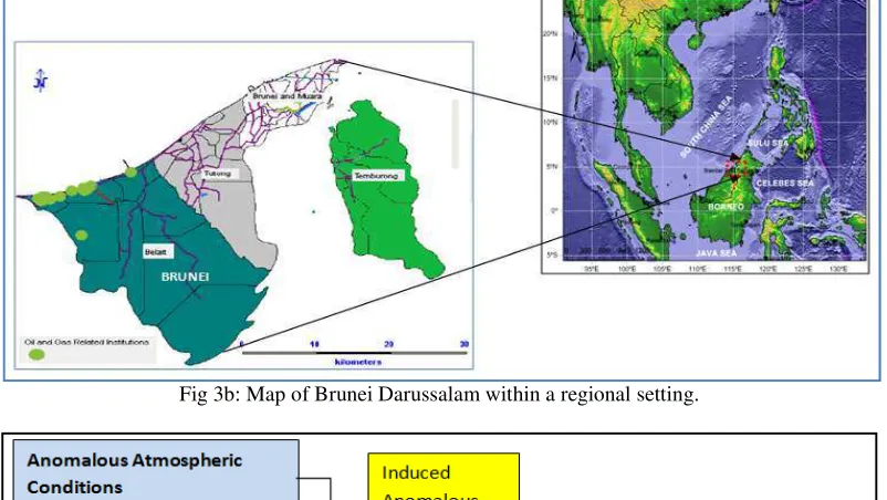
Fig 3b: Map of Brunei Darussalam within a regional setting.
Fig 3c:Conceptual framework for hydro-meteorological disasters occurrence in Brunei.
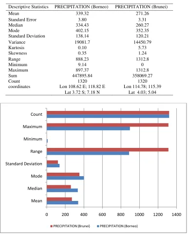
have been described. These specific rainfall records have been compared with the long term average kept by Brunei Darussalam Meteorological Department (BDMD) (1966-2008), and the calculated long term average for Borneo and Brunei (1901-2010), to ascertain the intensity of rainfall in recent years.
138.14 for both Brunei and Borneo respectively (Table 2, Fig 4). There is no significant difference in long term mean rainfall and deviation from the mean, between Brunei and Borneo (Table 2, Fig 4). Thus, rainfall characteristics and inducing mechanisms are more regional in nature. However, given the greater maximum rainfall in Brunei compared to Borneo, 1312.8 and 897.37, it can be safely asserted that there is a greater intensity of rainfall in Brunei than in wider Borneo. In January 2009, intense above normal rainfall was experienced with a total amount of 543.7mm recorded between 1st and 20th January 2009, in Brunei-Muara District alone, which was almost twice the long-term average (Brunei Times, 2009, January 22). Precisely, in a two day period, on January 19th and 20th respectively, 66.7mm and 167mm of rainfall was received, a total roughly equal to the long term average for the country. According to Brunei Darussalam Meteorological Department-BDMD, by January 26, 2009, the total rainfall recorded in Brunei was a stunning 708mm, approximately three times greater than the long term average (BDMD). Similarly, in January 2011, within three days, January 17-19th, record rainfall of over 180mm was experienced in Belait's Bukit Sawat and more than 80mm in Tutong
(Brunei Times, 2011, Jan 20;
http://ireport.cnn.com/docs/DOC-542736 accessed on 20th January, 2011). These long term records were also shattered several times throughout January 2014. Evidence of anomalous rainfall in January 2014 was provided by weather reports based on data from the BDMD. On the 22nd of January 2014 for example, in just 24 hours, a total rainfall of 188.4 mm was recorded, equivalent to more than two-thirds of the usual amount for all of January. The highest amount of rainfall recorded on the 22nd of January was in Belait District with 203.5mm while the lowest recorded was in Bandar Seri Begawan, 136.2mm (BDMD).
The variability of intense episodic rainfall at daily temporal resolution over the Island of Borneo in January 2009, 2011 and 2014 is shown in Fig 5a-b. On average, Brunei Darussalam received more rainfall than generally observed in Borneo but average daily January rainfall is highly variable. In January 2010 and 2013 rainfall was less intense (less than 10 mm) at the beginning of the month, peaking sharply in mid month (about 35 mm), and rapidly declining at the end of the month (less than 10 mm). In 2011, strong fluctuations 100mm/day represent periods of anomalous daily rainfall, which generally trigger flash-floods and landslides. Overall, the variance of January rainfall across Borneo is much stronger than that of Brunei characteristic variability of intense rainfall, coupled with significant spatial variability, the mechanism and causes of episodic anomalous rainfall are difficult to pinpoint, making prediction seem impossible, at least by local meteorological services using traditional weather forecasting methods or climate models.
3.2 Forcing Mechanisms/Drivers of Anomalous
Meteorological Events in Brunei (January
2009, 2011 and 2014)
It has been established from the assessment above that, despite the predictability of the monsoons, anomalous episodic rainfall is currently unpredictable using traditional weather prediction methods, due to the chaotic nature of the weather system. Therefore, key to understanding the initial triggers of floods and landslides is the analysis of variability of anomalous rainfall-inducing mechanisms at synoptic scale. These rainfall-inducing mechanisms observed during the months of January, 2009, 2011 and 2014 are presented below, including synoptic atmospheric circulation and tele-connections.
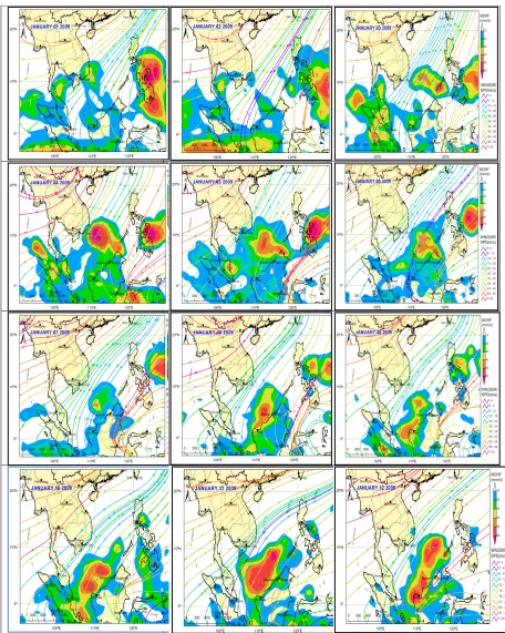
3.2.1. Daily Atmospheric Circulation Patterns and Average Daily Rainfall Distribution in South China Sea on the 1st-12thJanuary 2009
this time was not very intense in terms of magnitude, but was more widely distributed across the entire
month.
Table 2: Descriptive Statistics of rainfall data for Brunei Darussalam (1901 - 2010).
Fig 4: Pictorial illustration of descriptive Statistics of rainfall data for Brunei Darussalam during 1901 - 2010. The analysis is based on the data obtained from APDRC LAS (obtained with ANCLIM v.5.02).
0 200 400 600 800 1000 1200 1400
Mean Median Mode Standard Deviation Range Minimum Maximum Count
PRECIPITATION (Brunei) PRECIPITATION (Borneo)
Descriptive Statistics PRECIPITATION (Borneo) PRECIPITATION (Brunei)
Mean 339.32 271.26
Standard Error 3.80 3.31
Median 334.43 260.27
Mode 402.15 352.35
Standard Deviation 138.14 120.21
Variance 19081.7 14450.79
Kurtosis 0.10 5.73
Skewness 0.35 1.24
Range 888.23 1312.8
Minimum 9.14 0
Maximum 897.37 1312.8
Sum 447895.84 358069.27
Count 1320 1320
coordinates Lon 108.62 E; 118.82 E Lon 114.78; 115.39
Fig 5 (a-b): Average and variance of daily January Rainfall in Brunei and Borneo during 2009-2014 (mm). This is based on data obtained from APDRC (Analyzed with EVIEWS v.7).
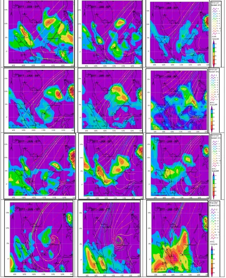
3.2.2. Daily Atmospheric Circulation Patterns and Average Daily Rainfall Distribution in South China Sea (1st -12th January 2011)
In January 2014, atmospheric circulation patterns across the SCS were much complex than in 2009. Winds during this time are generally observed to flow from two directions, namely: the traditional northeasterly direction and an easterly direction across intense rainfall zones over the Philippines. Thus these winds transport air-masses of different physical characteristics (cold/dry and warm/moist respectively) which generally create strong instability on their path, depositing moisture across southern SCS, predominantly on- and off shore of Borneo Island as well as across Southern Philippines. Another important characteristic of atmospheric circulation observed during this time is the strong wind curls or circular patterns which are produced as the monsoon winds reach landmasses and are diverted. In most cases, intense precipitation is concentrated in the centre of such wind curls and related atmospheric vortices (for example, the Borneo Vortex) particularly from January 10 - 12.Average wind speed in January 2011 was also observed to be significantly lower (5-11 m/s), an important condition for enhanced convective activity and vertical displacement of air-masses. Generally, the variability of atmospheric circulation pattern in January 2011 was in the following pattern: January 1-8, moderate wind curls across Borneo; January 9-12, strong wind curls and very intense vorticity off Borneo, predominantly off Brunei and northern coast of Sarawak; January 13-25, relatively normal northeasterly pattern and weak wind-stress curls across Borneo; January 26-28, strong wind-stress curls and strong vorticity off Brunei and northeast coast of Sabah.
3.2.3. Daily Atmospheric Circulation Patterns and Average Daily Rainfall Distribution in South China Sea on the 1st -12th January 2014
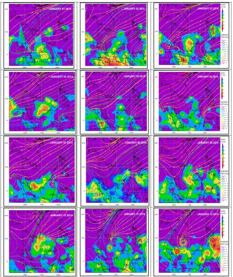
In January 2014, Borneo was the Primary point of convergence of air masses of diverse origins and characteristics due to the low pressure that developed over most of Southern South China Sea (SSCS), obviously spreading from the typhoon zone in the West Philippines Sea (Typhoon Haiyan). In addition, the low pressure over this zone characteristic of typhoon regions, is indicative of northward extension of the Inter-tropical Convergence Zone (ITCZ) beyond Lat 10o N. This spatial variability of the atmospheric pressure field is extrapolated based on the wind pattern to be partially split into two main sub-systems namely: East Equatorial Indian Ocean and Southeast SCS zones, which migrates back and forth between north Malacca Strait to northern Karimata Strait in the Indian Ocean and SCS respectively. The localized development, intensification and migration of extreme low within the broader SSCS low pressure zone is key to understanding air-mass advection and convergence, and intensification of the vortices which were at the origin of anomalous events. The mechanisms that expedited anomalous rainfall events in January 2014 were therefore forced by atmospheric circulation patterns and tele-connections that resulted in strong wind curls off West Malaysia, modulated by significant easterlies from the Indian Ocean, and the convergence of the warm westerly, easterly and colder northeasterly air-masses. This generated numerous complex air-sea circulation patterns and structures including: very intense atmospheric vorticity, strong wind curls, significant oceanographic gyres and eddies, strong and anomalous wave and swell behavior, off Borneo throughout the month. Zones of intense precipitation are thus mostly located in areas characterized by the development of significant atmospheric structures.
Apart from convergence and vorticity, frontal development was an important cause of rainfall in January 2014 as a result of the meeting of air masses of different characteristics over Borneo. For example, on January 1, a strong warm front developed as a result of
the encroachment of moisture laden westerly air-mass from the Indian Ocean, the regular cold N.E Monsoon air as well as the moisture laden easterly air mass from the Philippines. The lower level convergence of warm tropical moisture-laden westerlies and easterlies off the coastline of Borneo created instability and the development of strong convective cells forcing the air to rise faster. At the mid and upper troposphere, divergence occurs and rainfall is spread over the entire area. Wind speed also shows significant variability in southern South China Sea, increasing in velocity over time as a result of increasing vorticity and convergence. Wind speed off Borneo is observed to be approximately 10-28 m/s on January 1 - 6, increasing to about 30-45 m/s through Jan 7 - 12, 2014 characterized by stronger vorticity and/or convergence through the month. Prominent amongst the inducing mechanisms are the formation, strengthening and weakening of the cyclonic vortex off Borneo and its migration west, to eastern Indian Ocean and back east, generally following a well defined path at approximately Latitude 0o to 5o N, beginning in late December, 2013 through January, 2014. Fig 6 - 8 thus depict that spatial variability of rainfall over SSCS and in adjacent sea areas in the West Pacific and the Indian Ocean between January 2009, 2011 and 2014. They reveal that intense rainfall is positively correlated with significant atmospheric structures such as wind curls and vortices.
3.3 Sea Surface Temperature Anomalies
Across the South China Sea
Other than atmospheric circulation patterns, an analysis of oceanographic temperature conditions may have important effects on the lower atmospheric instability which may not be directly reflected in atmospheric circulation models. The mean monthly sea surface temperature conditions in the SCS in January 2009, 2011 and 2014 reveal that significant temperature departures were experienced in this marginal sea in January 2009 and 2011 during with most of the SCS region experienced abnormally cool conditions meanwhile normal conditions prevailed in 2014 due to the encroachment of cooler than normal waters from north to south across the SCS. Cooler waters denoted by the 296o K (22.9ºC) isotherm could be observed to have moved a considerable distance southward from its position along Northern SCS coast, north of Latitude 20o N to a position between Lat 12 and 20oN characteristic of La Nina event. In addition, the 300ok (26.9ºC) isotherm which is the average tropical sea water temperature was pushed further southward to approximately Latitude 0o - 6o N in January 2009 and 2014, just along the shoreline of Borneo, meanwhile its average position in January
2014 was Latitude 4o - 14o N. The piling of warm surface water along the coastline of Borneo while the northern part of the SCS cooled slightly may have initiated anomalous atmospheric processes and drove the rainfall. It is therefore generally observed that periods of anomalous rainfall correspond with negative temperature anomalies or La Niña type temperature anomalies for example in 2008/2009, 2010/2011 and in 2014/2015 (Fig 9b, Fig 10). El Niño type events on the other-hand (2009/2010 as well as the current 2015/2016 El Nino) coincide with periods of less intense rainfall and even wide-spread regional droughts. The mechanism described here are presented as major initiators or forcing of meteorological anomalies which are generally precursors to floods and landslides in Brunei that usually result in significant disruptions in affected communities, despite the limited temporal span of such triggering mechanisms.
3.4 Socio-Geographical and Environmental
Triggers of Floods and Landslide Disasters
The increasing frequency and magnitude hydro-meteorological disasters in Brunei is also compounded by geography, as there is very little slope in the flat coastal areas and the impacts of urban development which have resulted in the canalization of most rivers and streams in the country as well as limited/shallow storm drains which does not sufficiently allow flood waters to flow off the land especially during periods of anomalously intense rainfall. The whole country is generally susceptible to flooding and landslides due to the intense monsoon rainfall; the low-lying nature of most of the country, with an average elevation of just 15m above sea level, ranging from 0m in Brunei-Muara District to 1850m (Bukit Pagon) in Temburong District; the relatively small surface area of 5,265 km2 (2,033 sq mi) with a relatively dense hydrographic network of 500 km2 (190 sq mi); the nature of the soil which has been described as deeply weathered, highly leached1 and generally susceptible to erosion; canalization and shrinking of most river channels, civil engineering challenges; and the rapid rate of urbanization especially in the urban centres of Brunei-Muara District, where the capital Bandar Seri Begawan is located. Brunei - Muara is the smallest (570 km2) yet the most important, politically and economically, comprising more than half of the total population of the country2. This explains the intense clustering of -
1
http://www.britannica.com/EBchecked/topic/82119/Bru nei accessed on September 01, 2014
2
institutions in this district as well as the loss of much of the forest cover here and in neighbouring Tutong District. This is one of the most important flood/landslide-inducing factors in these two districts.
4. Discussion
Rain is one of the most important meteorological events vital in all spheres of human life; but the nature in which it occurs may also lead to untold and unforeseen suffering, from destructive floods and associated disasters, having significant implications on different landscape types and communities across the World. Convective activity and prominent synoptic features have been found to play a dominant role in the initiation and development of tropical weather systems and anomalous rainfall events in Southeast Asia and Borneo in particular. Surface heat fluxes, moisture and momentum and vertical mixing in the planetary boundary layer (PBL) and microphysical processes therefore play important roles in the development of deep convective activity that leads to intense rainfall events (Kumar et al., 2014; Li et al., 2005). Thus, based on an analysis that goes beyond the prevailing local atmospheric patterns and processes, the underlying mechanisms and causes of intense anomalous rainfall in Brunei have been identified generally unrelated from year to year, contrary to the generally held belief that such events are always the result of anomalous monsoons or climate change. The underlying forcing the events has therefore been observed as the direct result of ocean-atmospheric coupling and tele-connections at synoptic spatial scales, namely: anomalous monsoon atmospheric circulation patterns in the recent January 2014 episode, a global oceanographic/sea surface temperature anomaly related to La Nina, in January 2009, and a combination of both anomalous circulation and sea surface temperature anomalies in 2011 (Fig 6-10). In agreement with the present study, rainfall anomalies in East Asia have been found to be induced by different anomalous circulation systems closely related to an anomalous low-level anticyclone over the western North Pacific, the evolution of which is determined by large-scale equatorial heating anomalies and local air–sea interactions over south Asia and the western North Pacific associated with ENSO cycles (Wu et al., 2003). Other studies have observed that organized convective activity and mid-tropospheric cyclone (MTC) over the Arabian Sea off the west coast India characterized by circular structured systems, are the causative features for intense episodic rainfall events over S.E Asia (Kumar et al., 2014). The atmosphere and oceans are therefore intimately connected such that when ocean temperatures change rainfall patterns also change, potentially causing floods,
droughts and other related extreme meteorological events (NASA n.d.).
The major challenge to the management of hydro-meteorological disasters in Brunei can thus be clearly observed in the current perception and limited understanding of short term anomalies events and institutional responses to induced floods and landslide disasters which continue to wreak havoc in the country. In the midst of these challenges, public authorities and affected communities always seem baffled and unprepared, despite general progress to improve disaster management in the country. Disaster management in Brunei is therefore not robust enough fuel extreme anomalous weather conditions at synoptic to effectively incorporate mechanisms and forces that spatial scale. The underlying reasons for this include:
I. The apparent unpredictability and great variability that characterize anomalous meteorological events as well as their forcing mechanisms. This has generally fueled the inadequate understanding of the ocean-atmospheric coupling at synoptic scales that force extreme local meteorological conditions.
II. The general perception in the country that climate change is the main culprit in unusual weather events only helps to reinforce such lack of understanding. While climate change is arguably the most heated environmental issue in recent times, it is easy to dismiss such anomalous meteorological events presented here as evidence of climate change. Such a conclusion is erroneous for a couple of reasons:
a. It diminishes incentives to undertake research and provide scientific explanations to specific meteorological issues at different spatial and temporal scales
b. Since the most conspicuous characteristic of weather and climate is its variability, dismissing every anomalous climatic/meteorological phenomenon as ‘climate change’ may undermine understanding of specific processes and interactions at the ocean-atmosphere interface which may be at the origin of such phenomena.
Fig 9(a-b): Mean Sea surfa
Note: Depth profile: orange (55.69m); B
Source: Author’s work (data obtained fr
Fig 10: SST
Note: SST data are monthly hadisst1 SST Sea Surface Temperature data set (HadI
Fig 11: Map of Brunei showin
Note: produced by author with QG urbanization on forest cover www.statsilk.com/maps/download-fr y = 1E-06x + 0.4
R² = 0.000
27.6 27.8 28 28.2 28.4 28.6
S
S
T
(
oC
)
SST
A
rface temperature of the South China Sea (January 2009,
; Blue (45.45m); purple (35.28m); Green (25.16m); dark blue d from APDRC LAS available at http://apdrc.soest.hawaii.edu/
T variability and change across the SCS (1999-2013).
SST data, 1.0ox1.0o (January 1870 to September 2014). Source adISST). Retrieved from URL: http://apdrc.soest.hawaii.edu/da
wing intense institutional clustering, dense stream netwo
GIS showing intense institutional clustering in Brunei Muar ver in Tutongan Brunei-Muara District. Shapefile
free-shapefile-maps). 0.420
Time (years)
SST_annual av. SST_Annual change
B
09, 2011 and 2014).
ue (15.08m); Red (5.02m).
du/)
rce: Hadley Centre Sea Ice and /datadoc/hadisst.php
work and forest cover.
uara district and the impacts of files were obtained from
0 0.2 0.4 0.6 0.8 1
S
S
T
C
H
A
N
G
E
(
O C
These observations are in good agreement with emphasis on scale could prove to be more informative and supportive to a broad range of issues (Wilbanks and Kates, 1999) including: floods and landslides preparedness, mitigation and prediction. Although some authors suggest that tests for climatic changes should focus on changes in extreme events rather than on changes in climatic means (Mason et al., 1999), this perception is erroneous because it further intensifies the blurring of the differences between the terms ‘weather’ and ‘climate’ which is already very pervasive in the literature. Moreover, it leads to the risk of over-looking important well known natural cyclical phenomena such as ENSO (El Niño and La Niña) which induce anomalous weather events at synoptic to global scales. It therefore encourages the conflation of the effects ENSO with ‘climate change’ which according to mainstream perception is just another name for ‘anthropogenic global warming’. Based on results of the present study, a window of opportunity is opened to attempt to predict anomalous episodic rainfall events and consequently enhance early detection capabilities for floods and landslides. The forcing and mechanisms of anomalous rainfall in Brunei have therefore been well established to be a combination both natural and anthropogenic factors related to human developmental actions. The synergistic effects of these factors have increased intensity, magnitude and frequency of flood and landslide events have increased significantly in recent years. The role of anthropogenic forces in the severity of floods in Brunei as well as in other Asian states has been reiterated in news reports in the region34.
5. Conclusion
The present study has uncovered that mechanisms responsible for anomalous rainfall events in January 2011 and 2014 were strongly influenced by air-sea coupled circulation patterns which led to large trans-regional scale tele-connections in the form of the advection of strong warm easterly and westerly air anomalous rainfall. Studies which capture such fine temporal frames embedded in synoptic scale phenomena in ocean-atmosphere coupled systems as shown here are therefore strongly recommended in order to enhance understanding of intra-seasonal variability, and especially anomalous patterns within them. Thus, by studying the processes and mechanisms that induce rainfall helps to determine if it is part of severe weather systems. The results of this study can thus be a useful tool to assist meteorological models in heavy rainfall forecasting, and open up possibilities for detailed meteorological analysis related to changing weather systems. It therefore provides opportunities for indirectly predicting and understanding the mechanisms of short-term anomalous events for the purpose of initiating rapid response measures and minimizing potential socio-economic risks. With the knowledge that no single institution has expertise in the numerous issues related to hydro-meteorological disasters, integrated and effectively coordinated hydro-meteorological disaster management is therefore strongly recommended, characterized by regular and frequent stakeholder consultations.
References
ADB (2009). The Economics of Climate Change in Southeast Asia: a regional review. Asian Development Bank. AIPA (2012). Brunei Darussalam country report on the
disaster management. The 4th ASEAN Inter-Parliamentary Assembly Caucus, 30 April - 3 May, Bangkok, Thailand.
ADRMI (2010). Synthesis report on ten ASEAN countries disaster risks assessment. ASEAN Disaster Risk Management Initiative. URL: http://www.unisdr.org/files/18872_asean.pdf.
Bhatla R and Tripathi A (2014). The study of rainfall and temperature variability over Varanasi. International Journal of Earth and Atmospheric Science, 1(2): 90-94. Brunei Times (2014, Jan 24). Five stories on floods and landslides. Retrieved from http://www.bt.com.bn/newsnational/2014/01/24/five-stories-floods-and-landslides accessed in January 2014.
Brunei Times (2014, Jan 23). Floods and 44 landslides.
Retrieved from
http://www.bt.com.bn/frontpage-news-national/2014/01/23/floods-and44 landslides accessed in January 2014.
Brunei Times (2011, Jan 20). http://ireport.cnn.com/docs/DOC 542736. Accessed on 20th January, 2011).
Co-Chairs of the Preparatory Committee (2014, October 20). Zero draft: development of the post-2015 framework for disaster risk reduction. http://www.wcdrr.org/preparatory/post2015.
Countries Disaster Risks Assessment (2010, December). Synthesis report on ten ASEAN disaster risk
management initiative.
http://www.unisdr.org/files/18872_asean.pdf. Accessed
in December 2014.
Dartmouth Flood Observatory (2004). http://www.dartmouth.edu/~floods/archiveatlas/cause.h tm accessed in December 2014.
Doyle, E.E.H., Khan, S., Adler, C. et al. ( 2014). Reporting on the seminar - risk interpretation and action (RIA). Australasian Journal of Disaster and Trauma Studies, 18(1). URL: http://trauma.massey.ac.nz/issues/2014-1/AJDTS_18-1_Doyle.pdf.
EM-DAT (2014, December 1). The OFDA/CRED international disaster database, www.emdat.be - Université catholique de Louvain - Brussels- Belgium "Data version: v 12.07. http://www.emdat.be/result-country-profile.
Global Risk Data Platform (n.d.). http://preview.grid.unep.ch/index.php?preview=data&e vents=floods&lang=eng accessed in December, 2014. Dash SK, Kulkarni MA, Mohanty UC and Prasad K (2009).
Changes in the characteristics of rain events in India. Journal of Geophysical Research, 114(D10109): 1-12. Easterling DR, Diaz HF, Douglas AV, Hogg WD, Kunkel
KE, Rogers JC and Wilkinson JF (1999). Long-term observations for monitoring extremes in the Americas. Climatic Change, 42: 285-308.
Karl TR and Easterling DR (1999). Climate extremes: selected review and future research directions. Climatic Change, 42: 309-325.
Kumar S, Routray A, Chauhan R and Panda J (2014). Impact of parameterization schemes and 3DVAR data assimilation for simulation of heavy rainfall events along west coast of India 2 with WRF modeling system. International Journal of Earth and Atmospheric Science.
Kripalani RH and Kulkarni A (1997). Rainfall variability over S.E Asia - connections with Indian monsoon and ENSO extremes: new perspectives. International Journal of Climatology, 17: 1155-1168.
Loo YY, Billa L, Singh A (2015). Effect of climate change on seasonal monsoon in Asia and its impact on the variability of monsoon rainfall in Southeast Asia. Geoscience Frontiers, 6(2015): 817-823.
Mason SJ, Waylen PR, Mimmack GM, Rajaratnam B and Harrison JM (1999). Changes in extreme rainfall events in South Africa. Climatic Change, 41: 249-257. McClean D (2014). Revised HFA stresses political
leadership. Platform for the promotion of early warning (Unisdr Ppew). Accessed online at http://www.preventionweb.net/english/professional/news/v.php ?id=39967.
Meteorological department - Ministry of communications (2013, December). Government of Brunei Darussalam. URL: www.met.gov.bn.
NASA (n.d.). Total rainfall and sea surface temperature URL: http://earthobservatory.nasa.gov/GlobalMaps/view.php ?d1=TRMM_3B43M&d2=AMSRE_SSTAn_M. Accessed in January 2015
Tokyo conference on international study for disaster risk reduction and resilience: Towards a new Science and Technology to consolidate disaster risk reduction and sustainable development. 14th - 16th, January, 2015, the University of Tokyo, Tokyo, JAPAN.
Trenberth KE, Branstator G.W., Karoly D., Kumar, A., Lau N-C and Ropelewski, C. (1998). Progress during TOGA in understanding and modeling global teleconnections associated with tropical sea surface temperatures. Journal of Geophysical Research, 103: 14291.
Wallace JM and Gutzler DS (1981). Teleconnections in the Geopotential Height Field during the Northern Hemisphere Winter. Monthly Weather Review, 109, 784-812.
Wilbanks TJ and Kates RW (1999). Global change in local places: How Scale Matters. Climatic Change, 43(3): 601-628.
Natural hazards in Brunei Darussalam (2014, August).
Accessed online at
http://ubdgroupvmoodle.wikispaces.com/Natural+Haza rds+in+Brunei+Darussalam in August 2014.
TRMM: Extreme weather (2014, January). Deadly Philippine flooding and landslides. Retrieved from http://pmm.nasa.gov/node/973 posted on Friday, January 17, 2014.