RECOVER
AN AUTOMATED CLOUD-BASED DECISION SUPPORT SYSTEM
FOR POST-FIRE REHABILITATION PLANNING
J. L. Schnase a, *, M. L. Carroll b, K. T. Weber d, M. E. Brown b, R. L. Gill a, M. Wooten b, J. May d, K. Serr d, E. Smith d, R. Goldsby d, K. Newtoff c, K. Bradford c, C. Doyle c, E. Volker c, and S. Weber c
a
Office of Computational and Information Sciences and Technology, b
Biospheric Science Laboratory, and c DEVELOP Program Office NASA Goddard Space Flight Center, Greenbelt, Maryland USA (john.l.schnase, mark.carroll, molly.e.brown, roger.l.gill, margaret.wooten, kiersten.newtoff, kathryn.bradford, colin.s.doyle, emily.volker, samuel.j.weber)@nasa.gov
d
Idaho State University GIS Training and Research Center, Pocatello, Idaho USA (webekeit, mayjeff2, serrkind, smiteri6, goldrya2)@isu.edu
Pecora 19 / ISPRS TC 1 and IAG Commission 4 Symposium
KEY WORDS: Decision support systems, DSS, burned area emergency response, BAER, emergency stabilization and rehabilitation, ESR, cloud computing, rapid response
ABSTRACT:
RECOVER is a site-specific decision support system that automatically brings together in a single analysis environment the information necessary for post-fire rehabilitation decision-making. After a major wildfire, law requires that the federal land management agencies certify a comprehensive plan for public safety, burned area stabilization, resource protection, and site recovery. These burned area emergency response (BAER) plans are a crucial part of our national response to wildfire disasters and depend heavily on data acquired from a variety of sources. Final plans are due within 21 days of control of a major wildfire and become the guiding document for managing the activities and budgets for all subsequent remediation efforts. There are few instances in the federal government where plans of such wide-ranging scope and importance are assembled on such short notice and translated into action more quickly. RECOVER has been designed in close collaboration with our agency partners and directly addresses their high-priority decision-making requirements. In response to a fire detection event, RECOVER uses the rapid resource allocation capabilities of cloud computing to automatically collect Earth observational data, derived decision products, and historic biophysical data so that when the fire is contained, BAER teams will have a complete and ready-to-use RECOVER dataset and GIS analysis environment customized for the target wildfire. Initial studies suggest that RECOVER can transform this information-intensive process by reducing from days to a matter of minutes the time required to assemble and deliver crucial wildfire-related data.
* Corresponding author.
1. INTRODUCTION
1.1 Background
Each year wildfires consume an average of 4.2 million acres of land in the United States, according to the National Interagency Fire Center. The long-term recent decade average is even higher (NIFC, 2013). Fire suppression activities have been employed since the early 1900s to preserve land and protect people and infrastructure. National coordination of fire suppression activities between federal agencies is performed by the National Interagency Fire Center in Boise, Idaho. Fire management begins when a fire is named and an incident command team is assigned; it progresses through the stages of fire suppression including initial and extended attack, followed by containment, control, and extinguishment. If necessary, when the fire is contained, burned area emergency response (BAER) teams may be assigned. These teams have seven days to make an assessment of post-fire conditions and develop a preliminary stabilization and rehabilitation; they have 21 days to submit a final plan once the fire is controlled (BAER, 2014).
Over the past two decades, major advancements have occurred in remote sensing technologies and geographic information systems (GIS). These Earth observational data and software have been employed by fire managers and those who support them to map and characterize fire locations and their extent. These maps can be combined with other geospatial data depicting resources, infrastructure and population centers to identify areas of strategic importance.
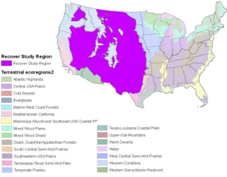
The majority of attention in mapping burned areas has historically focused on forested areas (Giglio, et al., 2009; Jirik, 2013; Kasischke, et al. 2011). However, the current project focuses on savanna fires, which research suggests can account for carbon emissions equivalent to or exceeding fossil fuel combustion by automobiles (Brustet, et al., 1992). For purposes of this study, savannas in the US are defined as semiarid grass and shrub dominated regions and are all located in the Western US (Figure 1). Much of these savannas are considered primary habitat for sage grouse, mule deer, and pronghorn antelope and are also used for livestock grazing. Fires can have profound short-term and long-term effects on the ecosystem.
Figure 1. Savanna ecosystem to be served by the RECOVER system. Image credit: Akiko Elders.
The current process of preparing a fire rehabilitation plan typically begins with the BAER team leader requesting a fire severity product. A difference normalized burn ratio (dNBR) layer derived from Landsat imagery is generally the product that is delivered (Cocke, et al., 2005; Key and Benson, 1999). This product may be integrated with other data, such as topographic information, soil properties, land use, presence of threatened or endangered species, threats to life and property, historic and recent conditions of soil moisture, to create the knowledge base upon which a remediation plan is crafted.
This data assembly, analysis, and decision-making process must happen quickly in order to meet the statutory requirement of producing a preliminary BAER plan within seven days. However, right now, this process involves substantial human intervention, and the information gathered depends on the availability of staff, time, and data for a particular region. Even though there is a wide array of information services available to the wildfire community, these services tend to focus on research coordination, information sharing, fire risk assessment, active fire management, and fires on forested lands. None of the existing services address the specific needs of post-fire stabilization and restoration planning and monitoring vegetation recovery for semiarid lands.
To assist the effort to manage savanna fires, we are developing an automated decision support system (DSS) called the Rehabilitation Capability Convergence for Ecosystem Recovery (RECOVER) (Carroll, et al., 2013). This system compiles all the necessary datasets for the BAER teams rehabilitation planning and provides them in an easy to use web map interface. In this paper, we describe the RECOVER system and the RECOVER project, report on the results of our Phase 1 feasibility studies, and describe our future plans for operational deployment.
1.2 Challenge Being Addressed
The RECOVER project is focusing on the restoration of fire-impacted ecosystems as well as post-fire management and rehabilitation. The work is being funded by the NASA Applied Sciences Program and spans all four of the Program's primary themes of Health, Disasters, Ecosystem Forecasting, and Water Resources. Idaho State University's (ISU) GIS Training and
Research Center (GIS TReC, 2014) is the lead organization supported by the NASA Goddard Space Flight Center's Office of Computational and Information Sciences and Technology Office and Biospheric Sciences Laboratory. Our specific focus has been on the semiarid regions of the Western US (Sayre, et al., 2009), with RECOVER framed around the problems and challenges faced by the BAER program and the special requirements of post-wildfire decision-making with regard to reseeding in savanna ecosystems.
Wildfire is a common hazard throughout semiarid savanna ecosystems. Following fire, ground vegetation is typically eliminated, leaving the landscape devoid of cover. These communities may then experience a series of adverse changes due to landslides, soil erosion, and invasive plant infestations (Hilty, et al., 2004; Pierson, et al., 2002). While wildfires have occurred for millennia, the high frequency and intensity of today’s wildfires contrast with those that occurred in the past (DeBano, et al., 1998; Thoren and Mattsson, 2002). These changes have led to unprecedented transformations to the semiarid savanna ecosystem.
Following wildfire, especially a high severity fire, the protective vegetation and organic litter cover are removed from hillsides, which can destabilize surface soils on steep slopes. Reseeding and other treatment approaches can rapidly stabilize the soil and promote water infiltration, thereby controlling erosion and preventing further loss of topsoil (Anderson and Brooks, 1975; Beyers, 2004; Miller, et al., 2003; Ribichaud, et al., 2006). Reseeding may also increase vegetation cover and forage availability for wildlife and livestock when appropriate initial plant establishments are used (Hubbard, 1975; Sheley, et al., 2997).
Given the importance of reseeding, it is not surprising that assessing the effects of wildfire, identifying areas that are likely to benefit from reseeding or other post-fire treatment, and monitoring ecosystem recovery in response to reseeding are important elements of BAER planning. However, as explained below, our initial feasibility evaluation has revealed that there also is significant interest in the use of RECOVER by active-fire incident response teams and by agency program managers for regional-scale, fire risk assessment.
1.3 Project Objectives
The primary objective of the RECOVER project has been to build a DSS for BAER teams that automatically brings together in a simple, easy-to-use GIS environment the key data and derived products required to identify priority areas for reseeding and monitor ecosystem recovery in savanna ecosystems following a wildfire. The fundamental propositions that have been tested during our Phase 1 feasibility study is whether RECOVER, the embodiment of such a system, substantively improves BAER team decision-making and, if so, whether the system can be deployed into practical use in the BAER program.1 Beyond these fundamental questions, we have also used this Phase 1 feasibility study to identify unanticipated uses for the RECOVER technology and build the foundation for broader agency collaborations with the US Forest Service.
1
Burned Area Emergency Response (BAER) is the name of the US Forest Service program; the corresponding program within the Bureau of Land Management is named Emergency Stabilitzation and Rehabilitation (ESR). For simplicity, we use BAER throughout in this paper.
1.4 Partner Organizations
Our primary partner organizations during the Phase 1 feasibility study have been the US Department of Interior (DOI) Bureau of Land Management (BLM) and the Idaho Department of Lands (IDL). BLM is the second largest agency in the eight-member National Interagency Fire Center the nation's wildfire coordinating center located in Boise, ID. BLM has operational responsibility for wildland fire on approximately 250 million acres of public land in the US, including approximately 12 million acres, or 22%, of the land base in Idaho. Idaho Department of Lands is the primary state-level agency responsible for dealing with wildfire in Idaho.
Since the RECOVER Phase 1 effort has focused on developing and evaluating capabilities in Idaho, the BLM/IDL teaming arrangement has been ideal for this feasibility study. In addition, partnering with BLM positions the project for broader regional- and national-scale operational deployment of RECOVER capabilities during Phase 2, as explained below. Likewise, interactions with NIFC through the BLM partnership open the possibility of RECOVER being adopted by other federal wildfire agencies.
ISU's GIS TReC has over many years developed a close working relationship with BLM and IDL in Idaho, which created a congenial and highly productive environment for this work. There has been significant involvement of key BLM and IDL collaborators at all stages of the project. We are working directly with, BLM's National Program Leader for Post Fire Recovery, as well as regional and state coordinators, field office personnel, and incident team leaders. Approximately one dozen individuals from the partner agencies have contributed to the Phase 1 study. Interactions with our agency collaborators by email and phone calls have taken place on a near daily basis. In addition, the project hosted a summer science team meeting and webinar that included demonstrations, training, and a field trip to Idaho fire sites.
2. THE RECOVER CONCEPT
2.1 Technical Approach and Innovations
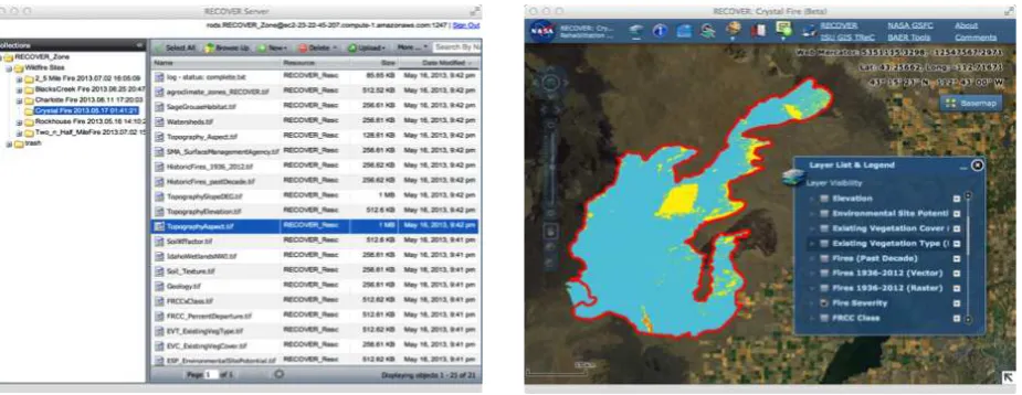
The RECOVER DSS is made up of a RECOVER Server and a RECOVER Client (Figure 2). The RECOVER Server is a specialized Integrated Rule-Oriented Data System (iRODS) data grid server deployed in the Amazon Elastic Compute Cloud (EC2). The RECOVER Client is a full-featured Adobe Flex Web Map GIS analysis environment. When provided a wildfire name and geospatial extent, the RECOVER Server aggregates site-specific data from pre-designated, geographically distributed data archives. It then does the necessary transformations and re-projections required for the data to be used by the RECOVER Client. It exposes the tailored collection of site-specific data to the RECOVER Client through web services residing on the Server. This automatic aggregation can take place in a matter of minutes.
In a typical scenario-of-use, RECOVER uses the rapid resource allocation capabilities of cloud computing to automatically gather its various Earth observational and ancillary data products. Additional data can be added manually if needed, and the entire data collection is refreshed throughout the burn so that when the fire is contained, BAER teams have at hand a complete and ready-to-use RECOVER dataset that is customized for the target wildfire. The RECOVER server continues to gather data after the fire to support long-term monitoring of ecosystem recovery.
RECOVER's technical innovations are its use of cloud puting, data grid technology, and web services. Cloud com-puting provides agility and cost-savings, because RECOVER's Amazon cloud servers are an "elastic" resource that can be dynamically created and removed as needed. Another benefit to cloud computing is that RECOVER’s compute and storage resources are acquired as an operational cost to the project, rather than through a time-consuming and potentially complex IT procurement: we simply pay Amazon for their services.
Figure 1. RECOVER Server and Client interfaces. For YouTube demonstrations, please see: http://www.youtube.com/watch?v=LQKi3Ac7yNU RECOVER Server
http://www.youtube.com/watch?v=SGhPpiSYpVE RECOVER Client
The iRODS data grid technology at the core of the RECOVER Server enables the extensive use of metadata to manage files and individualize data collections to specific wildfire sites. It also provides a full-featured database capability for long-term archiving of all relevant information associated with a wildfire.
Our extensive use of web services allows RECOVER’s site-specific data to be consumed by state-of-the-art web-based GIS applications, such as RECOVER’s Adobe Flex Web Map Client. This makes it possible for our agency partners to avail themselves of RECOVER’s analytic capabilities on any computer running a web browser, without having to acquire and maintain standalone GIS software. In addition, RECOVER’s web services architecture facilitates the future development of client applications that run on mobile devices. Most modern smartphones, tablets, etc. actually consist of just the display and user interface components of sophisticated applications that run in cloud data centers. This is the mode of work that RECOVER is intended to eventually accommodate.
These innovations and RECOVER's overall architecture have reduced development costs, enabled tailored, wildfire-specific services, and reduced the amount of time required in the development process. It is important to note that these innovations will have similar effects on operational deployment going forward.
2.2 Application of Earth Observations
Earth observations and ancillary data play a crucial role in BAER decision processes. Key NASA observational inputs for this feasibility study have included Landsat 8, MODIS, and AMSR-E. These data are used to develop fire intensity, fire severity, NDVI, fPAR, ET, and many other products of specific use to the wildfire community (Weber, et al., 2008a,b). An important goal of the project, however, is to position the RECOVER system and the BAER community to be consumers of SMAP and Suomi NPP data.
RECOVER automatically gathers approximately two dozen core data products, including information on the fire site's vegetation cover and type, agroclimatic zone, environmental site potential, fire regime condition class, geology, hydrology, soils, historic fires, topography, and evapotranspiration. RECOVER also automatically assembles about two dozen historic, biophysical parameters that can be important in understanding pre-existing conditions. These include previous years' monthly averages for soil moisture, NDVI, temperature, precipitation, relative humidity, and surface winds. To support long-term monitoring, RECOVER automatically updates NDVI and fPAR data on a monthly basis post-fire.
Some data products require manual preparation. These are added to the RECOVER Server shortly after the automatic aggregation occurs and includes information about fire history, fire intensity, and habitats of importance to threatened or endangered species, and other types of idiosyncratic data relevant to a particular fire location. As described below, these enhancements reduce the time required for data assembly from days to a matter of minutes.
2.3 Application of Climate Model Outputs
The RECOVER project is breaking new ground by introducing reanalysis data into wildfire decision processes. RECOVER is acquiring its historic climatology data from the Modern Era Retrospective-Analysis for Research and Applications (MERRA) collection. MERRA uses NASA's GEOS-5 assimilation system to produce a broad range of climate variables spanning the entire satellite era, 1979 to the present, essentially integrating the entire NASA EOS suite of observations into key variables used by the RECOVER DSS (Reinecker, et al., 2011).
3. FEASIBILITY STUDY
3.1 Approach to Feasibility Assessment
During our Phase 1 feasibility study, we developed system requirements from a detailed study of the 2006 Crystal Fire, which burned 250,000 acres, making it one of the largest wildfires in Idaho's history. We used interviews, demonstrations, and reviewed decision-making processes and the resulting rehabilitation plans for the Crystal Fire with individuals who actually worked on the Crystal Fire BAER team. We then used an agile software engineering approach to build the RECOVER system, emphasizing at each step of the development process close customer involvement and rapid, incremental improvements to a continuously available system.
The ISU team was primarily responsible for providing GIS expertise, developing the RECOVER Client, building the test collection of Idaho datasets and web services, and working directly with the agency partners to provide training and respond to requests for specialized data products. The NASA team had primary responsibility for building the RECOVER Server, cloud computing, and providing expertise on Earth observational and MERRA reanalysis data.
The RECOVER system was deployed into experimental use on five active fires from the 2013 season: the 2 1/2 Mile, Mabey, Pony, State Line, and Incendiary Creek Fires (Table 1). Using RECOVER, we directly supported the work activities and data
Fire Start Date End Date
Acres Burned
RECOVER Response
Time (min) RECOVER Client URL
Crystal 15-Aug-06 31-Aug-06 220,000 N/A http://naip.giscenter.isu.edu/recover/CrystalFire
Charlotte 2-Jul-12 10-Jul-12 1,029 N/A http://naip.giscenter.isu.edu/recover/CharlotteFire
2 ½ Mile 2-Jul-13 3-Jul-13 924 30 http://naip.giscenter.isu.edu/recover/2nHalfMileFire
Mabey 8-Aug-13 19-Aug-13 1,142 120 http://naip.giscenter.isu.edu/recover/MabeyFire
Pony 11-Aug-13 27-Aug-13 148,170 35 http://naip.giscenter.isu.edu/recover/PonyFire
State Line 12-Aug-13 18-Aug-13 30,206 40 http://naip.giscenter.isu.edu/recover/StateFire
Incendiary Creek 18-Aug-13 1,100 90 http://naip.giscenter.isu.edu/recover/IncendiaryFire
Table 1. RECOVER feasibility study fires
practices of agency colleagues as they responded to these fires, observing and gathering input from their experiences. Various ease-of-use, performance, and process factors were assessed.
BAER planning is a complex, multidimensional decision process. In order to accurately gauge the effects of our interventions, we assessed RECOVER's scientific, technological, and programmatic feasibility in terms of the following six criteria: Science Feasibility – (1) Does the RECOVER DSS work as well or better than current tools and methods in supporting the science and management decision making of BAER teams? (2) Is value added to BAER team decision processes by automatically assembling data and maintaining wildfire site-specific data in a central RECOVER Server?; Technology Feasibility – (3) Has RECOVER been integrated and tested in a relevant operational decision-making environment? (4) Is RECOVER able to produce required outcomes as fast or faster than conventional means?; and Programmatic Feasibility – (5) Can RECOVER reduce the cost or improve the effectiveness of data assembly, decision-making, and post-fire recovery monitoring? and (6) Is BLM and IDL willing to collaborate on the production development and operational deployment of RECOVER?
Criteria (1) and (2) were assessed qualitatively through daily interactions with individual BLM and IDL collaborators and as a group at the project's summer science team meeting. Successful prototype deployment was taken as the metric of success for criterion (3). Various ease-of-use, performance, and process factors were studied in the real-time context of the five active fires to assess criterion (4). Labor cost analyses for the
RECOVER's science feasibility was strongly substantiated by the feedback received on criteria (1) and (2). More than one dozen agency collaborators provided input into this study, including individuals directly responsible for gathering and analyzing wildfire-related data, such as GIS analysts, incident response team members, and natural resource managers, as well as senior managers responsible for long-term national-scale programmatic development.
The overwhelming response to RECOVER has been positive. The consensus view is that there is great value in RECOVER's ability to automatically collect data that would otherwise be assembled by hand. In addition, having a single data management environment where all relevant information about a fire can be maintained over time and easily accessed significantly improves standard practice. The RECOVER Client Web Map application is easily accessed on the web from any workstation and provides a comprehensive feature set for routine GIS analytics without the need to maintain stand-alone GIS applications on the workstation. This is a significant convenience and has the potential for substantially reducing the cost and complexity of IT systems administration for our partner agencies.
RECOVER's technical feasibility has been demonstrated by affirmative results for criteria (3) and (4). We have successfully validated the system in the context of active fires, which has allowed us to effectively estimate potential improvements to the target decision-making processes and project impacts on cost,
functionality, and delivery options. The most dramatic example of RECOVER's capacity for process improvement is in the significant reduction in the time required to gather wildfire data into a GIS analysis environment. Where it used to require a day or two of work and special knowledge about the data needed and where to retrieve the data, RECOVER's automatic aggregation coupled with minimal manual additions of data has reduced that time to minutes or hours (Table 1) and lowered risk by reducing the dependence on institutional knowledge.
RECOVER's programmatic feasibility has been demonstrated by affirmative results for criteria (4) and (5). Over the past four years, there have been on average 120 wildfires per year in Idaho and over 200 in 2012 alone. Looking at the data assembly task alone for these fires, and assuming that at least one GIS analyst for each partner agency takes a day or two to collect data and perform initial assessments, labor impacts could run as high as 4000 hours or more, nearly 2.0 FTEs. While this is substantial, we believe it represents only a fraction of the time that could be saved on data assembly and data management over the full information lifecycle of fire-related data.
The most significant programmatic impacts, however, are likely to be on the improved quality of science understanding and management decision-making that can result from shifting valuable staff resources away from the mundane task of data gathering to the crucial jobs of analysis, planning, and monitoring. These benefits are almost impossible to quantify. The process enhancements realized by RECOVER offer the prospect of fundamentally improving the quality of our partner's work practices. For this reason, there has emerged at all levels within our partner agencies strong support for the RECOVER project and a desire to move forward with operational deployment of these capabilities. We therefore satisfy criterion (6), which has led to a successful NASA Applied Sciences Utah, and Nevada, we will ultimately support all of the Western US. Initially, our primary customer will continue to be BLM and the state-level agencies responsible for wildfire response, stabilization, and rehabilitation, but the goal is to grow the partnership to include the US Forest Service, National Park Service, and other state and federal agencies that have a need for these capabilities. The Great Basin focus is at the specific request of BLM and represents a scale of development that we believe assures technical, economic, and political success in the early going. We will initially continue with our focus on savanna ecosystems, but the goal will be to extend RECOVER's capabilities to support forest ecosystems as well.
4.1 Baseline Conditions
Currently, regional- and state-scale fire risk assessment is a largely ad hoc process carried out by BLM program managers. It is a type of decision process that is crucial to the agency and influences long-range resource planning. However, the process now involves a great deal of manual data assembly, the gathering of information from a diverse and often difficult-to-access suite of online wildfire information resources, and integrating this information in useful ways into stand-alone desktop GIS applications.
Emergency preparations for active-fire response by incident managers involves the rapid gathering of data about the incident site prior to on-site arrival. Currently, the technical response can vary by incident team based on the specific training and experience of team members. Most incident teams have access to basic terrain maps, maps of roads and streams, etc., but use of advanced remote sensing and GIS capabilities is still not uniform between teams. With RECOVER, we will be able to arm response teams in advance with a complete collection of historic and current environmental data without depending on the incident team having a high-level GIS technician. By automatically generating data layers that are useful in understanding fire intensity and patterns of potential spread, we enhance the ability of incident teams to respond to the fire.
Post-fire rehabilitation plans of the sort developed by ESR and BAER teams are generally developed by multi-agency teams of specialists that include natural resource managers and scientists with expertise in various disciplines. Remote sensing imagery is used to complement field-based assessments, and several indicators derived from satellite imagery are used to characterize fire severity and intensity. For the current baseline condition, data collection in this setting is also a largely manual process performed by GIS analysts and resource managers. There is often limited access to critical data at the wildfire site, since again, most analysis environments are stand-alone applications running on field office workstations.
During post-fire recovery monitoring, fire managers are responsible for measuring and reporting the results of treatment plans. In the current baseline condition, this is generally carried out by field sampling. As a result, detailed, comprehensive evaluations are limited by budget and staff resources. PI Weber has demonstrated, through NASA-funded research that large-scale post-fire vegetation productivity in response to re-seeding can be monitored effectively using time-series NDVI and fPAR measurements (Chen, et al., 2012). RECOVER's ability to automatically assemble these post-fire metrics will significantly reduce the cost associated with recovery monitoring and improve the quality of our scientific understanding of what leads to successful treatments.
4.2 Implementation Approach and Key Milestones
We will focus on enabling four key work processes: fire risk, active-fire, and post-fire decision making and long-term recovery monitoring. Our approach will be to create a RECOVER deployment package — a collection of production-hardened technologies, technical documentation, training materials, and data services — that can become a model and mechanism whereby BLM and other agencies can replicate the deployment of RECOVER in other states.
Our implementation strategy will involve system development, data development, and operational deployment. The major work to be accomplished in system development is to move RECOVER V0.9, the experimental Client/Server platform used for Phase 1 feasibility analysis, to a fully functioning V1.0 of the system. We also will develop a mobile RECOVER Client that can run on iPads and iPhones (and Android clients if required by the customers). We will continue to use the agile software development approach that has proved successful in Phase 1, emphasizing close collaborations with our customers at all stages of development. Service level agreements (SLAs) will be defined, and the RECOVER Server and Clients will be security and performance hardened, validated, and tested as
needed in order to meet the requirements of a NASA/BLM-defined operational readiness review (ORR).
The data development work of Phase 2 will focus on completing RECOVER's core data catalog, which requires building a comprehensive base set of automatically retrievable data products, including the entire suite of MERRA variables and SMAP Level 4 soil moisture data when they become available. We also will work with our agency partners to develop specialized fire risk and post-fire data products of the sort described on in Section 4.4.
As described above, for operational deployment, we intend to design and develop a RECOVER deployment package that contains all the RECOVER components required to set up RECOVER on a state-by-state basis. The motivation for this is BLM's success in rolling out other new capabilities using this approach: the agency often partners with universities or other private-sector, non-profit entities at a state or regional level in order to accomplish its mission. BLM's long-standing partnership with ISU's GIS TReC in Idaho is an example of such a relationship. We will hold yearly science team meetings and define six-month milestones based on the major development threads described above.
4.3 Potential Impacts
According to our agency partners, data assembly is the most significant bottleneck in wildfire-related decision making. RECOVER dramatically reduces the time it takes to gather information, and it delivers the information in a convenient, full-featured, web-based GIS analysis environment. As a result, RECOVER's most important impacts are likely to be on the improved quality of science understanding and management decision-making that results from shifting valuable staff resources away from the task of data gathering to the more important tasks of analysis, planning, and monitoring. The potential magnitude of the resource shift is significant. If we extend to our three Great Basin states the labor impact example shown for Idaho in Section 3.2 above, as many as 6.0 FTEs per fire season could be mobilized in more productive ways.
4.4 Science Activities
RECOVER's ability to rapidly gather historic observational data and reanalysis climatology data along with measurements of current conditions makes it possible to do precision analyses that simultaneously inform our understanding of fire risk, active-fire fuel conditions, and post-fire rehabilitation potential. For example, for 2013's Pony Fire, we were able to use NDVI time series data to identify an early flush of vegetation in late February that fell off to a significantly lower-than-average level by June, suggesting there may be substantial senescent vegetation in this region: fine fuels that increase susceptibility to ignition. Also, 2013's mid-June NDVI levels were reduced by more than 10 percent compared with those over the previous decade, further confirming the anomaly (Figure 2). Being able to perform this type of analysis over automatically assembled data is seen as a potential game-changer by our partners.
RECOVER's potential as a research platform has led to a teaming arrangement with NASA's DEVELOP Program. DEVELOP fosters rapid feasibility projects that employ NASA Earth observations in new and inventive applications, demonstrating the widest array of practical uses for NASA's Earth observing suite of satellites and airborne missions.
DEVELOP application projects serve the global community by cultivating partnerships with local, state, regional, federal, and academic organizations, enhancing the decision and policy making process and extending NASA Earth Science research and technology to benefit society.
As many as four DEVELOP scientists will be working with the RECOVER project. The DEVELOP team will conduct research on the identification and quantification of anomalous conditions that contribute to the risk of fire and that influence post-fire recovery using remotely sensed data and climate model outputs. The specific objective of the DEVELOP science activities is to extend the RECOVER DSS to ingest and produce products that incorporate SMAP, Suomi NPP, and other observational data, along with MERRA reanalysis data for improved decision making and extension of RECOVER to new end-users, such as the US Forest Service and the National Park Service.
4.5 Other Contributions of the Project
The RECOVER project is working with Esri's Landscape Analysis project in what promises to be a valuable off-shoot of these efforts. The Landscape Analysis (LA) program comprises a suite of data services designed to enable better informed decisions related to natural resources. We are working with Esri to use applicable LA layers in RECOVER, and, in turn, are contributing high-resolution RECOVER data and MERRA reanalysis data to Esri’s program. This partnership highlights RECOVER's role as a broker for valuable wildfire-related data and extends RECOVER's impact to the broader GIS community.
5. CONCLUSIONS
The RECOVER DSS is an automated data assembly and web map decision support system that allows BAER teams to expedite the process of creating post-fire rehabilitation plans. Data are assembled for specific sites simply by providing a fire name and its spatial extent. Additional data sets can be added manually, and all data are maintained in a common format for ease of use. Initial prototype evaluations have demonstrated the effectiveness of RECOVER in reducing the time required to gather and deliver crucial data.
The RECOVER system is being extended to include research products from the fire science community and through the DEVELOP program. These extensions provides an opportunity to get new products to fire managers for evaluation and potential incorporation into management strategies. The agile architecture of RECOVER allows for incorporation of new datasets to the system by simply adding the web service to a list of “standard” products that are acquired in the data acquisition phase. This makes it possible to tailor RECOVER offerings to client needs.
The RECOVER decision support system will be operationally deployed over the next three years and available for use by federal and state agencies across the western United States. In this process, the RECOVER team is actively seeking input from the fire management community. Our goal is to work closely with end users to adapt the RECOVER system to the real and pressing needs of the fire response community.
ACKNOWLEDGEMENTS
This work represents the crucial and much appreciated contributions of many people. We thank our collaborators in the Bureau of Land Management and Idaho Department of Lands for their help designing and evaluating the RECOVER DSS. We are especially indebted to M. Kuyper, S. Jirik, and D. Repass for their support and leadership on the project. B. Holmes, A. Webb, B. Dyer, G. Guenther, T. Lenard, Z. Peterson, J. Nelson, D. Booker-Lair, R. Dunn, E DeYong, A. Mock, and A. Andrea provided helpful input throughout. We appreciate the long standing support and encouragement of R. Schwab at the National Park Service. D. Duffy, M. McInerney, D. Nadeau, S. Strong, and C. Fitzpatrick at NASA Goddard Space Flight Center provided crucial technical support, as did G. Haskett, T. Gardner, and K. Zajanc at ISU’s GIS Training and Research Center. We thank L. Childs-Gleason, J. Favors, and colleagues in the NASA DEVELOP National Program Office for their help connecting the RECOVER project to the DEVELOP mission. Finally, we wish to thank L. Friedl, V. Ambrosia, and A. Soja in the NASA Applied Sciences Program for their support, programmatic leadership, and encouragement. Funding for this project has been provided by the NASA Science Mission Directorate's Earth Science Applied Sciences Program.
REFERENCES
Anderson, W. E., and L. E. Brooks. 1975. Reducing erosion hazard on a burned forest in Oregon by seeding. Journal of Range Management 28: 349-398.
Beyers, J. L. 2004. Postfire seeding for erosion control: effectiveness and impacts on native plant communities. Conservation Biology 18: 947- 956.
Brustet, M., Vickos, J. B., Fontan, J., Podaire, A., and Lavenu, F. 1992. Characterization of Active Fires in West African Savannas by Analysis of Satellite Data: Landsat Thematic Mapper. In Global Biomass Burning, J. S. Levine, Ed., Cambridge Massachussets: MIT Press, pp. 53-60.
Carroll, M. L., Schnase, J. L., Weber, K. T., Brown, M. E., Gill, R. L., Haskett, G. W., and Gardner, T. A. 2013. A New Application to Facilitate Post-fire Recovery and Rehabilitation in Savanna Ecosystems. http://www.earthzine.org/2013/06/ 22/a-new-application-to-facilitate-post-fire-recovery-and-rehabilitation-in-savanna-ecosystems/.
Chen, F., Weber, K.T., and Schnase, J.L. 2012. Assessing the success of post-fire reseeding in semiarid rangelands using Terra MODIS. Rangeland Ecology and Management, Vol. 65, No. 5, pp. 468-474.
Cocke, A. E., Fule, P. Z., and Crouse, J. E. 2005. Comparison of burn severity assessments using Differenced Normalized Burn Ratio and ground data. International Journal of Wildland Fire, 14: 189-198.
DeBano, L. F., D. G. Neary, and P. F. Pfolliott. 1998. Fire's Effects on Ecosystems: New York, John Wiley and Sons, 333 pp.
DEVELOP, 2014. http://develop.larc.nasa.gov.
Giglio, L. Loboda, T., Roy, D. P. Quayle, B. and Justice, C. O. 2009. An active-fire based burned area mapping algorithm for the MODIS sensor. Remote Sensing of Environment, 113: 408-420.
Hilty, J. H., D. J. Eldridge, R. Rosentreter, M. C. Wicklow-Howard, and M. Pellant. 2004. Recovery of biological soil crusts following wildfire in Idaho. Journal of Range Management 57: 89-96.
Hubbard, W. A. 1975. Increased range forage production by reseeding and the chemical control of knapweed. Journal of Range Management 28: 406-407.
Idaho State University GIS Training and Research Center (GIS TReC), http://giscenter.isu.edu.
Jirik, S. 2013. “Personal Communication,” K. Weber.
Kasischke, E., Loboda, T., Giglio, L., French, N. H. F., Hoy, E. E., de Jong, B., and Riano, D. 2011. Quantifying burned area from fires in North American forests – implications for direct reduction of carbon stocks. Journal of Geophysical Research, 116.
Key. C. H., and Benson, N. C. 1999. The normalized burn ratio (NBR): A Landsat TM radiometric index of burn severity. http://www.nrmsc.usgs.gov/research/ndbr.htm.
Miller, J. D., W. J. Nyhan, and S. R. Yool. 2003. Modeling potential erosion due to the Cerro Grande Fire with a GIS-based implementation of the Revised Universal Soil Loss Equation. International Journal of Wildland Fire 12: 85-100.
National Interagency Fire Center (NIFC). 2014. www.nifc.gov. Pierson, F.B., D.H. Carlson, and K.E. Spaeth. 2002. Impacts of wildfire on soil hydrological properties of steep sagebrush-steppe rangeland. International Journal of Wildland Fire 11:145-151.
Rienecker, M.M., & Coauthors. 2011. MERRA: NASA’s Modern-Era Retrospective Analysis for Research and Applications. Journal of Climate, Vol. 24, No. 14, pp. 3624– 3648. Available online at http://dx.doi.org/10.1175/JCLI-D-11-00015.1.
Robichaud, P. R., T. R. Lillybridge, and J. W. Wagenbrenner. 2006. Effects of post-fire seeding and fertilizing on hillslope erosion in north-central Washington, USA. Catena 67: 56-67. Sayre, R., P; Comer, H. Warner, and J. Cress. 2009. A new map of standardized terrestrial ecosystems of the conterminous United States, US Geological Survey Professional Paper 1768, 17 p. (Also available online.)
Sheley, R. L., B. E. Olson, and L. L. Larson. 1997. Effect of weed seed rate and grass defoliation level on diffuse knapweed. Journal of Range Management 50: 39-43.
Thoren, F., and D. Mattsson. 2002. Historic wildfire research in southeastern Idaho. http://giscenter.isu.edu/research/techpg/ blm_fire/historic/wildfire_report.pdf.
Weber, K. T., S. Seefeldt, and C. Moffet. 2009. Fire severity model accuracy using short-term, rapid assessment versus long-term, anniversary date assessment. GIScience and Remote Sensing. 46(1): 24-38
Weber, K. T., S. Seefeldt, C. Moffet, and J. Norton. 2008. Comparing fire severity models from post-fire and pre/post-fire differenced imagery, GIS Science and Remote Sensing 45(4): 392-405
Weber, K. T., S. S. Seefeldt, J. Norton, and C. Finley. 2008a. Fire severity modeling of sagebrush-steppe rangelands in southeastern Idaho. GIScience and Remote Sensing 45: 68-82.