J. Biol. Indon. Vol 7, No.2 (2011)
Vol. 7, No. 2 Desember 2011 Akreditasi: No 816/D/08/2009 BOGOR, INDONESIA
JURNAL
BIOLOGI
INDONESIA
ISSN 0854-4425
JURNAL
BIOLOGI
INDONESIA
ISSN 0854-4425
Deforestation in Bukit Barisan Selatan National Park, Sumatra, Indonesia Suyadi
195
Study of Pteridophyte Diversity and Vegetation Analysis in Jatikerep Legonlele and Nyamplung, Karimunjawa Island Central Jawa
Fahreza Saputra & Labibah Qotrunnada
207
Javan Leaf Monkey (Trachypithecus auratus) Movement in a Fragmented Habitat, at Bromo Tengger Semeru National Park, East Java, Indonesia
M.Hari Subarkah, Novianto Bambang Wawandono, Satyawan Pudyatmoko, Subeno , Sandy Nurvianto, & Arif Budiman
213
Impact of Invasive Ant Species in Shaping Ant Community Structure on Small Islands in Indonesia
Akhmad Rizali, Abdul Rahim, Bandung Sahari, Lilik Budi Prasetyo, & Damayanti Buchori
221
Relationship Different Riparian Vegetation Cover with Stream Conditions in Cikapinis Stream, West Jawa
Della Kemalasari & Devi N. Choesin
231
Affect of Canopy Stratum and Methods of Breaking Seed Dormancy on Seedling Growth of Calliandra tetragona Beth. and Acacia tamarindifolia (L.) Willd. Indriani Ekasari
243
Shoot Tip Culture of Nepenthes albomarginata Lobb ex Lindl. In Vitro Lazarus Agus Sukamto, Mujiono, Djukri, & Victoria Henuhili
251
Variasi Gen Mitokondria Cytochrome b pada Dua Jenis Burung Kakatua Putih (Cacatua alba dan C. moluccensis)
Dwi Astuti 263
JURNAL
BIOLOGI
INDONESIA
ISSN 0854-4425
J. Biol. Indon. Vol 7, No. 2 (2011)
Jurnal Biologi Indonesia diterbitkan oleh Perhimpunan Biologi Indonesia. Jurnal ini memuat hasil penelitian ataupun kajian yang berkaitan dengan masalah biologi yang diterbitkan secara berkala dua kali setahun (Juni dan Desember).
Editor Pengelola Dr. Ibnu Maryanto Dr. I Made Sudiana Deby Arifiani, S.P., M.Sc
Dr. Izu Andry Fijridiyanto
Dewan Editor Ilmiah Dr. Abinawanto, F MIPA UI Dr. Achmad Farajalah, FMIPA IPB
Dr. Ambariyanto, F. Perikanan dan Kelautan UNDIP Dr. Aswin Usup F. Pertanian Universitas Palangkaraya Dr. Didik Widiyatmoko, PK Tumbuhan, Kebun Raya Cibodas-LIPI
Dr. Dwi Nugroho Wibowo, F. Biologi UNSOED Dr. Parikesit, F. MIPA UNPAD
Prof. Dr. Mohd.Tajuddin Abdullah, Universiti Malaysia Sarawak Malaysia Assoc. Prof. Monica Suleiman, Universiti Malaysia Sabah, Malaysia
Dr. Srihadi Agungpriyono, PAVet(K), F. Kedokteran Hewan IPB Y. Surjadi MSc, Pusat Penelitian ICABIOGRAD
Drs. Suharjono, Pusat Penelitian Biologi-LIPI Dr. Tri Widianto, Pusat Penelitian Limnologi-LIPI
Dr. Witjaksono Pusat Penelitian Biologi-LIPI Alamat Redaksi
Sekretariat
d/a Pusat Penelitian Biologi - LIPI
Jl. Ir. H. Juanda No. 18, Bogor 16002 , Telp. (021) 8765056 Fax. (021) 8765068
Email : [email protected]; [email protected] Website : http://biologi.or.id
Jurnal ini telah diakreditasi ulang dengan nilai A berdasarkan SK Kepala LIPI 816/ D/2009 tanggal 28 Agustus 2009.
J. Biol. Indon. Vol 7, No.2 (2011)
JURNAL BIOLOGI
INDONESIA
J. Biol. Indon. Vol 7, No.2 (2011)
KATA PENGANTAR
Jurnal Biologi Indonesia yang diterbitkan oleh PERHIMPUNAN BIOLOGI INDONESIA edisi volume 7 nomer 2 tahun 2011 memuat 17 artikel lengkap, tujuh artikel diantaranya telah dipresentasi pada seminar ATCBC di Bali 2010. Penulis pada edisi ini sangat beragam yaitu dari Balai Penelitian Besar Penelitian Bioteknologi dan Sumber daya Genetik Pertanian Bogor, Balai Tanaman Sayuran Lembang, Balai Besar Penelitian Veteriner Bogor Kementerian Pertanian, BATAN.
Fak. MIPA-Biologi Universitas Indonesia, Fakultas Kehutanan UGM Yogyakarta, Fakultas Kehutanan dan Fakultas Pertanian IPB Bogor, Sekolah Tinggi Hayati dan Departemen Tehnik Kimia ITB Bandung, Fakultas Pertanian Universi-tas Borneo, Tarakan, UniversiUniversi-tas Negeri Yogyakarta, FakulUniversi-tas Sain dan Tehnologi Universitas Islam Hidayatullah Jakarta, Kebun Raya Cibodas LIPI, Puslit Biologi LIPI, Puslit Oseanografi LIPI, PEKA dan Asosiasi Pelestari Curik Bali, Taman Safari Cisarua Bogor. Topik yang dibahas pada edisi ini meliputi bidang Botani, mikrobiologi, zoologi, remote sensing.
J. Biol. Indon. Vol 7, No. 2 (2011)
UCAPAN TERIMA KASIH
Jurnal Biologi Indonesia mengucapkan terima kasih dan penghargaan kepada
para pakar yang telah turut sebagai penelaah dalam Volume 7, No 2, Juni 2011: Drs. Roemantyo, Puslit Biologi-LIPI
Dr. Dwi Astuti, Puslit Biologi-LIPI M.Fathi Royani, MA., Puslit Biologi-LIPI Dr. Iwan Saskiawan, Puslit Biologi-LIPI
Drs. Ary Wahyono, Puslit Kemasyarakatan-LIPI Muhamad Irham MSc., Puslit Biologi-LIPI Dr. Enung Fuad, Puslit Bioteknologi-LIPI Drs. Boeadi, Puslit Biologi LIPI (Purna Bakti) Dr. Edi Mirmanto, Puslit Biologi-LIPI
J. Biol. Indon. Vol 7, No.2 (2011)
DAFTAR ISI
Deforestation in Bukit Barisan Selatan National Park, Sumatra, Indonesia Suyadi
195
Study of Pteridophyte Diversity and Vegetation Analysis in Jatikerep Legonlele and Nyamplung, Karimunjawa Island Central Jawa
Fahreza Saputra & Labibah Qotrunnada
207
Javan Leaf Monkey (Trachypithecus auratus) Movement in a Fragmented Habitat, at Bromo Tengger Semeru National Park, East Java, Indonesia
M.Hari Subarkah, Novianto Bambang Wawandono, Satyawan Pudyatmoko, Subeno , Sandy Nurvianto, & Arif Budiman
213
Impact of Invasive Ant Species in Shaping Ant Community Structure on Small Islands in Indonesia
Akhmad Rizali, Abdul Rahim, Bandung Sahari, Lilik Budi Prasetyo, & Damayanti Buchori
221
Relationship Different Riparian Vegetation Cover with Stream Conditions in Cikapinis Stream, West Jawa
Della Kemalasari & Devi N. Choesin
231
Affect of Canopy Stratum and Methods of Breaking Seed Dormancy on Seedling Growth of Calliandra tetragona Beth. and Acacia tamarindifolia (L.) Willd.
Indriani Ekasari
243
Shoot Tip Culture of Nepenthes albomarginata Lobb ex Lindl. In Vitro Lazarus Agus Sukamto, Mujiono, Djukri, & Victoria Henuhili
251
Variasi Gen Mitokondria Cytochrome b pada Dua Jenis Burung Kakatua Putih (Cacatua alba dan C. moluccensis)
Dwi Astuti
263
Kajian Pendahuluan: Perpindahan Gen dari Tanaman Kentang Transgenik Katahdin RB ke Tanaman Kentang Non Transgenik
A. Dinar Ambarwati, M. Herman, Agus Purwito , Eri Sofiari,& Hajrial Aswidinoor
277
Virus Influenza Novel H1N1 Babi di Indonesia
NLP Indi Dharmayanti, Atik Ratnawati, & Dyah Ayu Hewajuli
289
Karakterisasi Produk Biosolubilisasi Lignit oleh Kapang Indigenus dari Tanah Pertambangan Batubara di Sumatera Selatan
Irawan Sugoro, Sandra Hermanto,D. Sasongko,D. Indriani & P. Aditiawati
J. Biol. Indon. Vol 7, No. 2 (2011)
Potensi Virus Avian Influenza H5NI Isolat A/Ck/West Java/Pwt-Wij/2006 Sebagai Vaksin R. Indriani, NLP I Dharmayanti, R.M.A Adjid, & Darminto
Variasi dan kekerabatan genetik pada dua jenis baru belimbing (Averrhoa leucopetala Rugayah et Sunarti sp nov dan A. dolichorpa Rugayah et Sunarti sp nov., Oxalidaceae)
berdasarkan profil Random Amplified Polymorphic DNA Kusumadewi Sri Yulita
Pengaruh Dinamika Faktor Lingkungan Terhadap Sebaran Horisontal dan Vertikal Katak Hellen Kurniati
Merekonstruksi Habitat Curik Bali Leucopsar rothschildi Stresemann, 1912 di Bali Bagian Barat
Mas Noerdjito, Roemantyo &Tony Sumampau
Struktur dan Komposisi Vegetasi Hutan Semusim Habitat Curik Bali (Leucopsar rothschildi Stresemann, 1912) di Kawasan Labuan Lalang, Taman Nasional Bali Barat
Roemantyo
Sumbangan Ilmu Etnobotani dalam Memfasilitasi Hubungan Manusia dengan Tumbuhan dan Lingkungannya
195
Jurnal Biologi Indonesia 7 (2): 195-206 (2011)
Deforestation in Bukit Barisan Selatan National Park, Sumatra, Indonesia
Suyadi
Indonesian Institute of Sciences (LIPI), M.Sc in Information Technology for Natural Re-sources Management, Bogor Agricultural University (IPB)
ABSTRAK
Deforestasi di Taman Nasional Bukit Barisan Selatan, Sumatra, Indonesia. Studi ini menerangkan deforestasi dan penyebabnya di Taman Nasional Bukit Barisan Selatan (TNBBS) yang merupakan habitat bagi berbagai satwa liar yang terancam punah. Penelitian ini menghubungkan metode penginderaan jauh dengan metode wawancara untuk memperkirakan laju deforestasi dan mengetahui penyebab deforestasi. Hasil wawancara menunjukan bahwa penggundulan hutan di TNBBS di mulai sejak tahun 1960an, lebih awal dari perkiraan sebelumnya. Hasil tersebut di perkuat oleh hasil analisa citra-satelit yang menunjukan bahwa sebelum 1972 tutupan hutan seluas 46.100 ha atau sekitar 13% dari luas hutan di TNBBS telah hilang. Rata-rata laju deforestasi sejak 1972 hingga 2006 adalah 0,64% per tahun. Hanya sekitar 67.225 ha hutan yang tersisa pada 2006 dari 310.670 ha hutan pada tahun 1972, atau sekitar 22% tutupan hutan telah hilang sejak 1972 hingga 2006. Laju deforestasi di TNBBS paling tinggi di hutan perbukitan (9.01 km2/tahun), kemudian hutan dataran rendah (7.55 km2/tahun), and hutan
pegunungan (3.43 km2/tahun). Deforestasi tertinggi terjadi pada dekade pertama (1972-1985), setiap tahunnya seluas 28 km2 hutan di babat habis, kemudian pada dekade berikutnya
(1986-1996) deforestasi hanya 15 km2/tahun, namun pada dekade terakhir deforestasi meningkat kembali
(21 km2/tahun). Pelaku yang secara fisik membabat hutan di TNBBS adalah petani yang tinggal di dalam dan di sekitar hutan. Meskipun demikian, yang menjadi penyebab terpenting deforestasi di TNBBS adalah penyebab tidak langsung seperti illegal logging, Hak Pengusahaan Hutan, tingginya harga kopi, lemahnya penegakan hukum, dan situasi sosial-ekonomi di tingkat lokal dan nasional. Faktor-faktor tersebut merupakan faktor external yang mendorong petani untuk membuka hutan di TNBBS atau memperluas lahan garapannya.
Kata kunci: Deforestasi, Penyebab deforestasi, Survei wawancara, Penginderaan jauh, Taman Nasional Bukit Barisan
INTRODUCTION
Bukit Barisan Selatan National Park (BBSNP) is the third-largest protected area on the Indonesian island of Sumatra, and tropical deforestation constitutes one of the greatest threats to its conserva-tion. The United Nations Framework Convention on Climate Change/
UNFCCC (2007) declared that the inter-national community faces the urgent task of reducing tropical deforestation as one of a suite of measures to reduce the im-pacts of global climate change and to maintain biological diversity. One of many responses of conservation biologists to this threat has been to develop an array of tools for measuring and monitoring
196
Suyadi
deforestation, many of which use re-motely sensed data collected by satellites (Saatchi et al. 2001). Satellite-based datasets can provide fine-scale measures of deforestation rates; however, many aspects of deforestation processes that are related to social phenomena (includ-ing causes of deforestation) cannot be measured using satellite sensors (Turner et al. 2001). Therefore, approaches that link administrative and remote-sensing data are important for understanding trends in and causes of deforestation. Most studies linking remote-sensing ob-servations and administrative data have been undertaken at the scale of the ad-ministrative units (Wood & Skole 1998). However, Mertens et al. (2000) do inte-grate remote-sensing data and household surveys to understand the impact of mac-roeconomic change on deforestation pro-cesses in South Cameron.
BBSNP contains some of the larg-est tracts of tropical forlarg-est remaining on Sumatra and is a good example of the dramatic loss of tropical forest in Indo-nesia. Although BBSNP was declared a World Heritage site by UNESCO (deci-sion 28COM 14B.5), in the past decade BBSNP's forest cover has declined dra-matically. Since the early 1970s, much of the forest cover in BBSNP has been cleared, but there are conflicting esti-mates of the scale and rates of loss. For example, Kinnaird et al. (2003) found that between 1985 and 1999 the park lost more than 661 km2 of forest (28%). On
other hand, Gaveau et al. (2007) showed that the average rate of deforestation from 1972 to 2002 in an area of 1.17 million ha in southwest Sumatra that includes
BBSNP was 1.69% per year.
In addition, BBSNP is also a perfect example of the complex causes of de-forestation. BBSNP has a long border of approximately 700 km, and the park is there are villages, agriculture, and plan-tation forestry adjacent to the park (Kinnaird et. al. 2003). The high rates of interaction between the people and the forest in the area that borders BBSNP may induce humans to enter the park to clear more forest. Consequently, wildlife such as tigers (Panthera tigris sumatrae) and elephants (Elephas sumatranus) also travel outside the park borders and damage crops and livestock. In addition, conflicts over land ownership between Lampung-based local groups and the government, as well as conflicts among governmental institutions, have promoted further deforestation (Kusworo 2000; Verbist et al. 2004).
The dramatic loss of forest cover in BBSNP is attributed to variety of factors including illegal logging, timber conces-sions (denoted HPHs in Indonesia), con-version to agriculture (by opportunistic settlers and those arriving through Indonesia's official transmigration pro-gram), development of estate crops, and forest fires (Sunderlin et al. 2001; Suyanto et al. 2000; Holmes 2002). How-ever, information about the causes of deforestation in BBSNP is lacking. Gaveau et al. (2007) reports that coffee prices, law enforcement, and rural pov-erty are the primary causes of defores-tation in southwest Sumatra (including BBSNP). Suyadi & Gaveau (2007) show that in a small area (Pemerihan) within BBSNP, the cause of deforestation is
il-197
Deforestation in Bukit Barisan Selatan National Park
legal logging.
This study integrates a time series of satellite images and interview data to measure deforestation rates and to de-termine the root causes of deforestation in BBSNP. The detailed objectives are to provide an estimate of deforestation rates and maps of deforestation patterns and to unravel the causes of deforesta-tion in BBSNP. This study documents the extent of deforestation in the park from 1972 to 2006 and examines the causes of deforestation using interview data. This information is crucial for future con-servation because BBSNP's forest is home to some of the world's most en-dangered large mammals and is within the major watershed for southwestern Sumatra.
MATERIALS AND METHODS
Bukit Barisan Selatan National Park (BBSNP) is the third-largest protected area (356,800 ha) on the Indonesian
is-land of Sumatra (Figure 1). Located in southwestern portion of the island (4o 31'
to 5o 57' S and 103o 34' to 104o 43' E), it
forms part of the provinces of Lampung and Bengkulu. The park extends 150 km along the Bukit Barisan mountain range and is composed of diverse topography that ranges from the coastline in the south to forested mountains in the north. Rain-fall is seasonal, ranging from 3,000 mm to 4,000 mm annually, and temperatures fluctuate between 22oC and 35oC. The
park is narrow in shape, with a perimeter greater than 700 km in length, and is bor-dered by villages, agriculture, and plan-tations (Kinnaird et al. 2003). Encroach-ments for agriculture and illegal logging are rife in BBSNP. Forest loss has be-come the greatest threat to the conser-vation of Bukit Barisan Selatan National Park.
This study uses LANDSAT images acquired in the years 1972, 1976, 1978, 1982, 1985, 1989, 1994, 1997, 2000, 2002, 2004, and 2006 to detect forest-cover
Figure. 1. Study area in southern Sumatra showing Bukit Barisan Selatan National Park (BBSNP) and forest type based on elevation.
198
Suyadi
change across Bukit Barisan Selatan National Park. All images had cloud cover of less than 2.0% and the LANDSAT images from 2006 are Scan Line Cor-rector (SLC) off which the gaps have been filled by Wildlife Conservation So-ciety (WCS). The images were geo-ref-erenced using 2006 scenes that were verified with Ground Control Points (GCPs) collected in the field by staff of WCS using Global Positioning Systems (GPS). All data were projected to the Universal Transverse Mercator (UTM) projection, Zone 48 South.
Forest and non-forest land-cover classes were classified using a supervised Maximum Likelihood Classification (MLC). I edited the classification results by manual on-screen digitization (particu-larly in areas where the MLC algorithm often produces misclassification errors). For land-cover change analyses, I used post-classification comparisons and time-series analyses (via transition matrixes), with forest cover at each point in time used as the base forest cover for the next point in time. This method detected the area of deforestation and any fluctuations in deforestation rates over time. Analy-ses were conducted via spatial analyAnaly-ses using a GIS software (ArcView 9.2) with geo-processing extensions. In this paper, forest refers to non-modified forest ar-eas of old-growth vegetation dominated by closed-canopy tree cover (50%). De-forestation or forest loss is defined as complete removal of forest cover over an area equivalent to 1 ha. Non-forest comprises agricultural areas, grasslands, village enclaves, and unknown, non-for-ested vegetation types.
The study used a 30-m resolution ASTER Digital Elevation Model (DEM) to categories forest types by elevation. Three elevation-based categories were selected using the classification system of the Indonesian Ministry of Forestry and Kinnarid et al. (2003). The classes are lowland forest (0-500 m), hill forest (501-1000 m), and submontane forest (>1001 m). The ASTER DEM was as-sembled at the BBSNP office. The BBSNP boundary (at a scale of 1:25,000) was obtained from the BBSNP office and was corrected in the field using GPS tech-nology by a team from the BBSNP Of-fice, WCS, and World Wildlife Fund (WWF). Logging trails, road networks, and villages were assembled from WCS data. Locations of illegal logging were manually interpreted through on-screen digitization and were verified in the field with a GPS.
This research used data from inter-views conducted in 2005-2006 in 1384 households within selected villages in and around the Park. Interviews were con-ducted using Indonesian and local lan-guages (Lampungnese and Javanese). Before interviewing in each village, the WCS team and I conducted group dis-cussions (focus groups) to identify the specific characteristics of the local soci-ety. The respondents were farmers who own cultivated land in or within 5 km of the park boundary and villagers who la-bored on these farms. In order to avoid reticence, (especially in areas where con-flicts with park management are fre-quent) the interviews began with non-sensitive questions about conservation in general, progressively focused more
spe-199
Deforestation in Bukit Barisan Selatan National Park
cifically on deforestation, and finally ad-dressed issues concerning the respon-dents' own farmland in Bukit Barisan Selatan National Park.
Semi-open interview techniques were used in this research with a stan-dardized questionnaire that addressed the following: 1) personal details (including household demographics); 2) farming practices; 3) respondent origins (i.e., mi-grants or indigenous residents); 4) land ownership; 5) respondent expectations about increased land scarcity; and 6) re-spondent attitudes towards the surround-ing forest. The questions included when respondents first cleared forest cover for farmland, for what reasons farmers cleared forest cover, and the area of for-est that was cleared. These qufor-estions served to make the data more compa-rable to forest-cover data from time-se-ries of satellite images
I assembled time-series statistics (1972 to 2006) on annual international (US dollar) and local (Indonesian Rupiah, Rp) coffee prices from the International Cof-fee Organization's (ICO) indicator price reports and statistics on human popula-tion from the provincial government. The local coffee price time-series data were deflated by the Consumer Price Index (CPI, 2006=100) for southern Sumatra to account for the increase in local con-sumer prices and agricultural input prices over time.
The study also used local and na-tional historic records about government policies, socio-economic issues, law en-forcement (including evictions of people from BBSNP), timber concessions (le-gal logging), and ille(le-gal logging. All of
these data were collected from the BBSNP office, the Directorate General of Forest Protection and Nature Conser-vation (PHKA), and provincial govern-ment.
RESULTS
The Patterns of Deforestation in Bukit Barisan Selatan National Park (BBSNP)
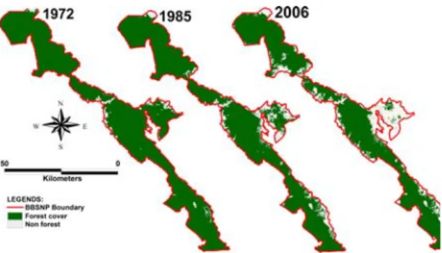
The household interview surveys show that forest clearing in Bukit Barisan Selatan National Park (BBSNP) began in the 1960s. The image analyses justify this finding and show that before 1972, approximately 46,100 ha of forest cover in BBSNP was lost representing a 13% loss of the total area of BBSNP (356,800 ha). The image analyses also indicate that the majority (80%) of forest conversion resulted from agricultural development. The interview data indicate that the first forest clearing in BBSNP occurred in Sidorejo (Kaur, Bengkulu) in 1961, five years after transmigrants from Java came to a village (Desa Trans Kulik) near BBSNP (±2 km from the park boundary). Subsequently, deforestation began in Pemerihan (West Lampung) in 1966 and in Way Nipah (Tanggamus) and Suoh (West Lampung) in 1970.
From 1972 to 2006, deforestation in the BBSNP averaged 20 km2 (0.64%)
per year. In total, 67,225 ha of the origi-nal 310,670 ha of forest that was present in 1972 were lost, representing a 22% loss from 1972 to 2006. The trends in forest loss from 1972 to 2006 are plotted in Figure 2 and mapped in Figure 3. Fig-ure 2 showed that two peaks in forest
200
Suyadi
loss occurred in 1978-1982 and 1997-2000. The average rate of deforestation is alarmingly high and results in declining forest cover. In contrast, the average rate of reforestation is only 1.13 km2 per year
(representing 0.94% per year).
Forest loss in BBSNP began at the buffer of the park and has progressed towards the park interior. The average rate of deforestation in the 10-km buffer is 1.83% per year, and the rate is higher inside the park. Deforestation rates in BBSNP vary with elevation. Deforesta-tion rates in lowland forests (0-500 m), which represent 43% of the area of BBSNP, were 7.55 km2/year. In hill
for-ests (501-1000 m), which represent 38% of the park area, they were 9.01 km2/
year, and in montane forests (>1001 m) they were 3.43 km2/year. Figure 4 shows
that (as was the case for rates of total forest loss in BBSNP) peak forest loss in all three forest types occurred during 1978-1982 and 1997-2000. In the recent years (2004-2006), the rate of forest loss in lowland forests has decreased gradu-ally, but forest loss in hill forests and mon-tane forests has tended to increase.
De-Figure 2. Forest loss in Bukit Barisan Selatan National Park, 1972-2006
.
forestation rates also vary with slope. On relatively flat slopes (0-20°), forest loss averaged 16.5 km2/year but the rate
dropped to 0.8 km2/year on the steepest
slopes (>40°).
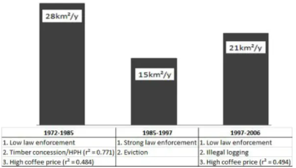
Based on the temporal patterns of deforestation, the study period was di-vided into three decades of deforestation. The highest deforestation rate in BBSNP (about 28 km2 per year) occurred in the
first decade (1972-1985). In the second decade (1986-1996), the deforestation rate decreased to 15 km2 per year. In the
most recent decade (1997-2006), the de-forestation rate in the park increased and approximately 21 km2 of forest cover
were lost per year (Figure 5).
The Causes of Deforestation in Bukit Barisan Selatan National Park
The agents who play the most im-portant physical roles in forest-cover change in BBSNP are the farmers who live in and around the park. These agents operate in separate locations and have little contact with one another; their few interactions are not sufficient to drive farmers to clear forest. Farmers
them-201
Deforestation in Bukit Barisan Selatan National Park
Figure 3. The spatial distribution of forest loss in Bukit Barisan Selatan National Park, 1972-2006
Figure 4. Forest loss in the three types of forest in Bukit Barisan Selatan National Park, 1972-2004 0 5 10 15 20 25 30 1972-1985 1986-1996 1997-2006 Decades (Years) F o re st los s ( k m ²/year )
Figure 5. The three decades of deforestation in Bukit Barisan Selatan National Park selves are not the primary cause of
de-forestation; instead, there are external factors that drive farmers to clear forest cover in BBSNP. The external factors are varied, and differ according to the location. The interview surveys showed that transmigration was one of the exter-nal factors that induced farmers to clear
more forest in Sidorejo, BBSNP in 1961. This factor resulted in relatively more open access to the forest. The other ex-ternal factors that spurred farmers were the political crisis in 1965 and the actions of timber concession companies (Perusahaan HPH) in the 1970s. Linear regression analyses indicate that logging
202
Suyadi
trails that were built by concession com-panies are significantly correlated with forest loss (r2= 0.771, p = 0. 085). These
external factors drove farmer to clear more forest cover in the areas of Pemerihan, Way Nipah, and Suoh. Im-age analyses indicate that deforestation rates caused by timber concessions in these areas were higher than deforesta-tion rates caused by transmigradeforesta-tion (in Sidorejo for example).
Image analyses also show that de-forestation rates increased dramatically in 1978-1982 and 1997-2000 (54.28 km2
and 44.48 km2 per year, respectively).
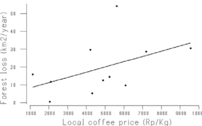
The regression analyses indicate that the causes of deforestation (the external fac-tor) in these years were high coffee prices in 1978 (r2 = 0.484, p = 0.058) and
high coffee prices again in 1997 (r2 =
0.494, p = 0.061). A linear regression model (Figure 6) indicates that local cof-fee prices closely predicted deforestation rates inside BBSNP (P = 0.005, r2 = 0.47).
Thus, higher local prices for coffee in-duced faster deforestation (b = 0.029, P = 0.028).
DISCUSSION
This research shows that defores-tation in Bukit Barisan Selatan National Park has occurred since the 1960s. How-ever, Kinnaird et al. (2003) report that deforestation in BBSNP began in 1985, and Gaveau et al. (2007) show that de-forestation in BBSNP began in 1972. These are two essential sides in the on-going debate over the rate of deforesta-tion in BBSNP. On the one hand, Kinnaird et al. (2003) estimate that the deforestation rate in BBSNP from 1985 to 1999 was 2.0% per year; they pre-dicted that in 2010 about 70% of the BBSNP would be agricultural lands or village enclaves. On the other hand, Gaveau et al. (2007) finds that the aver-age rate of deforestation in BBSNP from 1972 to 2002 was 0.63% per year. The current study shows that the average rate of deforestation from 1997 to 2006 was 0.64% per year and that 69% of the area of BBSNP is currently forest and 31% is agricultural lands.
Figure 6. Results of the linear regression (solid line) between forest loss and local coffee prices.
203
Deforestation in Bukit Barisan Selatan National Park
Suyadi & Gaveau (1997) found that the external cause that drives farmers to clear forest in Pemerihan, BBSNP is il-legal logging. They explain that ilil-legal log-ging causes limited damage to the forest, but that this illegal activity prompted farm-ers to go inside the park and to clear more forest for agricultural land.
The causes of deforestation in BBSNP are complex and vary with place and time. Thus, this study does not only focus on a single set of deforestation driv-ers, but recognizes several forms of de-forestation causes that each play a sig-nificant role in the process of forest con-version. The three levels of deforesta-tion causes suggested by Sunderlin & Resosudarmo (1996) are agents, imme-diate causes, and underlying causes. In BBSNP, the agents that physically clear forest are farmers. The immediate causes of deforestation (which trigger agents to clear more forest cover) are timber con-cessions, illegal logging, and high coffee prices. Finally, the underlying causes of deforestation (which directly influence the behavior of the immediate causes) are lack of law enforcement and local and national socio-economic conditions. The most important causes of deforestation in BBSNP are the immediate and the underlying causes because these causes trigger more clearing of forest cover by farmers.
This study applies the three-levels explanation suggested by Sunderlin & Resosudarmo (1996) to clarify the causes of deforestation in the three decades dur-ing which deforestation occurred (Figure 5). The immediate causes of increasing deforestation in the first decade
(1972-1985) were timber concessions (r2 =
0.771) and high coffee prices (r2 =
0.484); lack of law enforcement was an underlying cause. In areas where this se-quence took place, farmers (the agents) merely filled a "vacuum" created by the loggers. In the second decade (1986-1996), deforestation in BBSNP decreased due to strong law enforcement after the third World Parks Congress (WPC) held in Bali in 1982. During this time, hundreds of families were evicted from the Pemerihan area in BBSNP (including my family and myself). In the most recent decade (1997-2006), deforestation rates in the park increased because of the high coffee prices that occurred as an effect of the Asian economic crisis of 1997-1998 and because of illegal logging that was a result of lack of law enforcement after the fall of President Suharto in 1998. Both of these factors had had a direct influ-ence on the behavior of the illegal log-gers and farmers. Figure 7 illustrates the patterns of forest loss and the causes of increase or decrease in deforestation rates.
Management Implications
This study and two previous studies (Kinnaird et. al. 2003) showed that de-forestation is one of the greatest threats to the conservation of BBSNP. Loss of forest has proven to be one of the most difficult and complex problems facing Indonesia's conservation agencies. If we are to conserve the forests of BBSNP, we must take immediate and dramatic actions and a holistic approach. Forest management should focus on strategic efforts such as conserving the remaining
204
Suyadi
forests as well as forest restoration, law enforcement, increasing the participation of local people, increasing financial sup-port, and increasing the incomes of farm-ers around the park.
Forest management must concen-trate on conserving the remaining forest within the park. Managers may also need to consider restoration of lost or heavily disturbed forest and of the forest edge. The strong law enforcement present in the early 1980s in BBSNP greatly re-duced deforestation especially in the southern portion of BBSNP. Therefore, law enforcement is necessary to safe-guard the integrity of BBSNP from farm-ers who would otherwise clear the for-est. Keane et al. (2008) suggested that law enforcement interventions are also necessary to protect endangered species. Law enforcement is also important for reducing illegal logging activities (Suyadi & Gaveau 2007).
This study found that in recent years, the deforestation rate in hill and montane forests has tended to increase. The ma-jority of hill and montane forests located in northern BBSNP that contain "active" encroachments have experienced little
Figure 7. The trends in and causes of increase or decrease in deforestation over three decades.
regrowth. I predict that deforestation in the northern section of the park be will higher than deforestation in the southern section. Gaveau et al. (2007) classified the northern section of the park into a low law-enforcement zone in which ac-cessibility for rangers is difficult and ranger patrols are lacking. On other hand, accessibility for farmers is easy (near). Therefore, the study suggests that ranger patrols should also be focused in the northern section of the park. The park manager should reactivate the patrol of-fices or may also consider building new patrol offices in the northern section of the park. This is important for creating better accessibility of northern section for rangers.
CONCLUSIONS
Deforestation in Bukit Barisan Selatan National Park began in the 1960s, which is earlier than previous estimations. Forest loss between 1972 and 2006 pro-ceeded at an average rate of 20 km2 per
year or 0.64% per year. More than 22% of the forest in Bukit Barisan Selatan National Park was lost from 1972 to
205
Deforestation in Bukit Barisan Selatan National Park
2006. This indicates that deforestation is one of the greatest threats to the conser-vation of BBSNP. Deforestation has oc-curred in lowland forests, higher-eleva-tion hill forests and montane forests, but in recent years, deforestation in hill and montane forests has tended to increase gradually. This study predicts that the deforestation rate in the northern section of the park (which contains a large area of hill forest and montane forest) will be higher than deforestation in the southern section, which is dominated by lowland forest.
The agents that have the main physi-cal role in forest clearing in BBSNP are farmers that live in and around the park. However, the most important of the causes of deforestation are immediate causes such as timber concessions, ille-gal logging, and high coffee prices; these causes induce farmers to cleared more forest. Finally, lack of law enforcement and socio-economic conditions are the important underlying causes that drive the immediate causes.
ACKNOWLEDGMENTS
This study was supported by the Russell E. Train Education for Nature Program of the World Wildlife Fund, the Royal Geographical Society (with IBG) with a Royal Dutch Shell International Leadership and Capacity Building Programme Bursary, and the Wildlife Conservation Society. I would like to ex-press gratitude to Mr. Russel E. Train, to Dr. Marion Adeney for review, and com-ments, to Dr. Margaret F. Kinnaird and Dr. David Gaveau. Special thanks are
given to the interview teams from Wild-life Conservation Society, Center for In-ternational Forestry Research, and LSM Ulayat.
REFERENCES
Gaveau, DLA., Wandono, & H., F. Setiabudi. 2007. Three decades of deforestation in southwest Sumatra: have protected areas halted forest loss and logging, and promoted re-growth?. Biol.Cons 134: 495-504. Holmes, DA. 2002. The predicted extinc-tion of lowland forests in Indone-sia. Pages 7-13 In E. Wickrama-nayake, E. Dinerstein, C. J. Loucks, D. M. Olson, J. Morrison, J. Lamoreux, M. McKnight, & P. Hedao, editors. Terrestrial ecore-gions of the Indo-Pacific: a con-servation assessment. Island Press, Washington, D.C.
Keane, A., JPG. Jones, E. Jones, & G., Milner-Gulland. 2008. The sleeping policeman: understanding issues of enforcement and compliance in conservation. Animal Cons 11: 75-82.
Kinnaird, MF., EW. Sanderson, TG. O'Brien, HT. Wibisono, & G. Woolmer. 2003. Deforestation trends in a tropical landscape and implications for endangered large mammals. Cons. Biol. 17: 245-257. Kusworo, A. 2000. Perambah hutan atau kambing hitam? Potret sengketa kawasan hutan di Lampung. Pustaka Latin, Bogor.
Mertens, B., WD. Sunderlin, & O. Ndoye. 2000. Impact of
macroeco-206
Suyadi
nomic change on deforestation in South Camerron: Integration of household survey and remotely-sensed data. World Development 28: 983-999.
Saatchi, S., D. Agosti, K. Alger, J. Delabie, & J. Musinsky. 2001. Examining fragmentation and loss of primary forest in the southern Bahian At-lantic Forest of Brazil with radar imagery. Cons. Biol. 15: 867-875. Sunderlin, WD., A. Angelsen, DP. Resosudarmo, &A. Dermawan. 2001. Economic crisis, small farmer well-being and forest cover change in Indonesia. World Development 29: 767-782.
Sunderlin, WD. & IAP. Resosudarmo. 1996. Rates and causes of defor-estation in Indonesia: towards a resolution of the ambiguities. Oc-casional Paper No.9. Center for International Forestry Research, Bogor.
Suyadi, & DLA. Gaveau, 2007. Akar Penyebab Deforestati di Sekitar Sungai Pemerihan, Taman Nasional Bukit Barisan Selatan, Lampung Barat. Jurnal Berita Biologi 8(4): 279-290
Suyanto, S., RA. Dennis, I. Kurniawan, F. Stolle, P. Maus,& G. Applegate. 2000. The underlying causes and
impact of fires in South-east Asia. Site 1. Sekincau, Lampung Prov-ince, Indonesia. CIFOR, ICRAF and USFS, Bogor, Indonesia. The United Nations Framework
Conven-tion on Climate Change (UNFC CC). 2007. Decision2/CP.13: Re-ducing emissions from deforesta-tion in developing countries: ap-proaches to stimulate actions. In: United Nations Climate Change Conference. Bali, Indonesia. Turner, W., EJ. Sterling, & AC. Janetos.
2001. Contributions of remote sens-ing to biodiversity conservation: a NASA approach. Cons. Biol. 15: 832-834.
Verbist, B., & G. Pasya. 2004. Perspektif sejarah status kawasan hutan, konflik dan negosiasi di Sumberjaya, Lampung Barat-Propinsi Lampung. Agrivita 26: 20-28.
Wood, CH., & D. Skole. 1998. Linking satellite, census and survey data to study deforestation in the Brazilian Amazon. Pages 70-93 In D. Liverman, E. F. Moran, R. R. Rinduss, & P. C. Stern, editors. People and pixels: linking remote sensing and social science. Na-tional Academy Press, Washington, DC.
Received: Juli 2010 Accepted: April 2011
J. Biol. Indon. Vol 7, No.2 (2011)
PANDUAN PENULIS
Naskah dapat ditulis dalam bahasa Indonesia atau bahasa Inggris. Naskah disusun dengan urutan: JUDUL (bahasa Indonesia dan Inggris), NAMA PENULIS (yang disertai dengan alamat Lembaga/ Instansi), ABSTRAK (bahasa Inggris, maksimal 250 kata), KATA KUNCI (maksimal 6 kata), PENDAHULUAN, BAHAN DAN CARA KERJA, HASIL, PEMBAHASAN, UCAPAN TERIMA KASIH (jika diperlukan) dan DAFTAR PUSTAKA.
Naskah diketik dengan spasi ganda pada kertas HVS A4 maksimum 15 halaman termasuk gambar, foto, dan tabel disertai CD. Batas dari tepi kiri 3 cm, kanan, atas, dan bawah masing-masing 2,5 cm dengan program pengolah kata Microsoft Word dan tipe huruf Times New Roman berukuran 12 point. Setiap halaman diberi nomor halaman secara berurutan. Gambar dalam bentuk grafik/diagram harus asli (bukan fotokopi) dan foto (dicetak di kertas licin atau di scan).
Gambar dan Tabel di tulis dan ditempatkan di halam terpisah di akhir naskah. Penulisan simbol α,
β, χ, dan lain-lain dimasukkan melalui fasilitas insert, tanpa mengubah jenis huruf. Kata dalam bahasa asing dicetak miring. Naskah dikirimkan ke alamat Redaksi sebanyak 3 eksemplar (2 eksemplar tanpa nama dan lembaga penulis).
Penggunaan nama suatu tumbuhan atau hewan dalam bahasa Indonesia/Daerah harus diikuti nama ilmiahnya (cetak miring) beserta Authornya pada pengungkapan pertama kali.
Daftar pustaka ditulis secara abjad menggunakan sistem nama-tahun. Contoh penulisan pustaka acuan sebagai berikut :
Jurnal :
Hara, T., JR. Zhang, & S. Ueda. 1983. Identification of plasmids linked with polyglutamate production in B. subtilis. J. Gen. Apll. Microbiol. 29: 345-354.
Buku :
Chaplin, MF. & C. Bucke. 1990. Enzyme Technology. Cambridge University Press. Cambridge. Bab dalam Buku :
Gerhart, P. & SW. Drew. 1994. Liquid culture. Dalam : Gerhart, P., R.G.E. Murray, W.A. Wood, & N.R. Krieg (eds.). Methods for General and Molecular Bacteriology. ASM., Washington. 248-277.
Abstrak :
Suryajaya, D. 1982. Perkembangan tanaman polong-polongan utama di Indonesia. Abstrak Pertemuan Ilmiah Mikrobiologi. Jakarta . 15 –18 Oktober 1982. 42.
Prosiding :
Mubarik, NR., A. Suwanto, & MT. Suhartono. 2000. Isolasi dan karakterisasi protease ekstrasellular dari bakteri isolat termofilik ekstrim. Prosiding Seminar nasional Industri Enzim dan Bioteknologi II. Jakarta, 15-16 Februari 2000. 151-158.
Skripsi, Tesis, Disertasi :
Kemala, S. 1987. Pola Pertanian, Industri Perdagangan Kelapa dan Kelapa Sawit di Indonesia.[Disertasi]. Bogor : Institut Pertanian Bogor.
Informasi dari Internet :
Schulze, H. 1999. Detection and Identification of Lories and Pottos in The Wild; Information for surveys/Estimated of population density. http//www.species.net/primates/loris/ lorCp.1.html.
J. Biol. Indon. Vol 7, No. 2 (2011)
Kajian Pendahuluan: Perpindahan Gen dari Tanaman Kentang Transgenik Katahdin RB ke Tanaman Kentang Non Transgenik
A. Dinar Ambarwati, M. Herman, Agus Purwito , Eri Sofiari,& Hajrial Aswidinoor
277
Virus Influenza Novel H1N1 Babi di Indonesia
NLP Indi Dharmayanti, Atik Ratnawati, & Dyah Ayu Hewajuli
289
Karakterisasi Produk Biosolubilisasi Lignit oleh Kapang Indigenus dari Tanah Pertambangan Batubara di Sumatera Selatan
Irawan Sugoro, Sandra Hermanto,D. Sasongko,D. Indriani & P. Aditiawati
299
Potensi Virus Avian Influenza H5NI Isolat A/Ck/West Java/Pwt-Wij/2006 Sebagai Vaksin
R. Indriani, NLP I Dharmayanti, R.M.A Adjid, & Darminto
309
Variasi dan kekerabatan genetik pada dua jenis baru belimbing (Averrhoa leucopetala Rugayah et Sunarti sp nov dan A. dolichorpa Rugayah et Sunarti sp nov., Oxalidaceae) berdasarkan profil Random Amplified Polymorphic DNA Kusumadewi Sri Yulita
321
Pengaruh Dinamika Faktor Lingkungan Terhadap Sebaran Horisontal dan Vertikal Katak Hellen Kurniati
331 Merekonstruksi Habitat Curik Bali Leucopsar rothschildi Stresemann, 1912 di Bali
Bagian Barat
Mas Noerdjito, Roemantyo &Tony Sumampau
341
Struktur dan Komposisi Vegetasi Hutan Semusim Habitat Curik Bali (Leucopsar rothschildi Stresemann, 1912) di Kawasan Labuan Lalang, Taman Nasional Bali Barat
Roemantyo
361
Sumbangan Ilmu Etnobotani dalam Memfasilitasi Hubungan Manusia dengan Tumbuhan dan Lingkungannya
Eko Baroto Walujo