Available online at http://www.iaeme.com/ijciet/issues.asp?JType=IJCIET&VType=9&IType=12
Civil Engineering Department, Petra Christian University, Surabaya 60236, Indonesia
Joko Purnomo
Civil Engineering Department, Petra Christian University, Surabaya 60236, Indonesia
Daniel Tjandra
Civil Engineering Department, Petra Christian University, Surabaya 60236, Indonesia
ABSTRACT
The global sea level rise is rapidly increased as the result of climate change which indicated by the expansion of marine heat and ice melting. It was identified as one of the most contributing factors, which threatens coastal communities, even national economy of a country. The combination of groundwater flooding and coastal flood was reported to make a total loss of at least 5 billion rupiahs with respect to crop failure of tons of seaweed as well as fish lost. The aim of this research is to construct a topographic and bathymetric map using Unmanned Aerial Vehicles (UAV)/drone series DJI Phantom 3 Advanced. The UAV is used in companion with other instruments, such as total station and geodetic station. The UAV is used mainly to take aerial images, which is further processed to obtain contour maps. The results indicate that the contour maps are accurate and can be used to help in making appropriate decision to the global climate change.
Key words: Bathymetry map, climate change, coastal adaptation, topography map, UAV
1. INTRODUCTION
Global sea level rise affects not only local coastal community, but also threatens national economic of the whole country. This sea level rise is caused by global climate changing continuously, such as heat expansion of seawater as well as melting of ice blocks. As a consequence to this phenomenon is threatening of food and water availability, infrastructures, health, and security of the community [1]. Previous research revealed that sea level rise also affects economic growth and prosperity level in regional scale such in land loss, infrastructures damage, socio-capital loss, extra cost on facing extreme conditions, coastal flood, as well as additional cost to protect the coast line, where it is common in many places in Indonesia [2].
Since Indonesia is one of country, which has wide marine area, therefore mentioned case can be major problem if global climate changing data is not available. The availability of such data is important especially for coastline area, because the coastal flood is common to occur in Indonesia. Coastal flood is fluctuation pattern of sea water, which is affected by moon-sun gravitational forces towards sea water mass [3]. The impact of coastal flood is disturbance to daily activities, access, damage of infrastructures near the site, loss of residing places, and loss of job.
Based on the statistics, Sidoarjo is one of the most affected region by coastal flood with huge loss (see Fig. 1). Many houses in the village including Tanjung Sari, Tegal Sari, and Kali Alo sub-villages were submerged. Thus, a comprehensive research is essential to be conducted to solve the problem. On January 25, 2018, preliminary survey was conducted to obtain direct testimony from the villagers. Based on the interview, the coastal flood emerged on December 1, 2017 causing break out of sea walls in Kali Alo. Furthermore, in December 3 and 9 the water also submerged Tanjung Sari at 40-50 cm height. Finally, in December 9 other sea walls in Tanjung Sari also collapsed which further causing fish loss and led to crop failure.
Figure 1. Coastal flood in Kupang Village, Sidoarjo [12]
2. MATERIAL AND METHOD
2.1. Research AreaThe research area was selected to represent three crucial locations to the coastal flood occurrence. The three spots are located at estuary of Kali Alo River (A), Tegal Sari River (B), and the estuary of Tegal Sari River (C) as depicted in Fig. 2.
To obtain topographic and bathymetric data three instruments were used, including Geodetic Station, Total Station and Unmanned Aerial Vehicles (UAV)/Drone. To obtain accurate measurement, benchmark point was gained from by deploying Geodetic Station, which was needed to be firstly defined before operating Total Station and Drone. Based on the best consideration and justification on site, the benchmark point was determined at 7°29’60”S; 112°49’36”.
Drone can be used to record and take stable images from the air. UAV was applied to calculate water depth and created a technique for coastal mapping [4, 5], while another author more specially looked into bathymetries [6] along with focused on coastal monitoring [7]. Another recent study specified that drone were extensively appropriate for monitoring the surf zone [8].
Figure 2. Research site (Universal Transverse Mercator 49 S)
The grid resolution that was used for coastal research directly influences the usability of the results. Then, bathymetry filtering on nearshore process mode results has been researched [9]. On the other hand, a method to increase bathymetry throughout time. The method updates watercraft echo sounder data which was infrequent with the use of nearly continuous sampling altimeters [10].
well as to continue mapping if singly-fly recording was not possible due to limiting battery life, i.e. around total flight of 15 to 25 minutes per battery pack
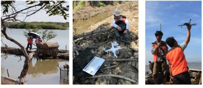
As can be seen in Fig. 3, it shows the data measurements using drone in Kalialo and Tegal Sari. A set of laptops was also needed to check real time mapping results before deciding primary recording to obtain the possibly best results. For bathymetry mapping, UAV are deployed on the boat during the measurements data.
Figure 3. Data measurements using total station and drone
2.2. Topographic and Bathymetric Data
To obtain bathymetric and topographic data, Drone DJI Phantom 3 Advanced and Drone Mavic were used. The drones were launched to capture the aerial images from 150 m height. A total of five times flight was conducted to ensure all critical locations could be mapped. Furthermore, the images were processed to generate the contour maps. Total station was used to determine the precise coordinate of the benchmark points. The points were then capture from above using drone for further processing.
3. RESULTS
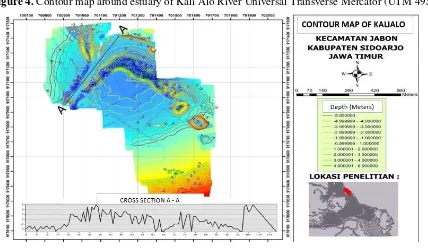
Images obtained from aerial recording via drones is further analyzed in ArcGis to generate contour map from Digital Terrain Model (DTM) data. The first phase result is usually rough, thus need to be smoothed by digitation method. Furthermore, the smoothened contour map is finished by applying layout and legends as depicted in Fig. 4. Notable contour at estuary of Kali Alo River shows low elevation at -4 m by sea level.
Figure 4. Contour map around estuary of Kali Alo River Universal Transverse Mercator (UTM 49S)
Figure 5. Cross Section of Kali Alo using Universal Transverse Mercator (UTM 49 S)
4. CONCLUSIONS
ACKNOWLEDGEMENT
The authors would like to express appreciation for the support of the sponsors of Directorate General of Higher Education Indonesia and Kopertis VIII, project number: 002/SP2H/LT/K7/KM2017.
REFERENCES
[1] R.C. Asuncion and M. Lee, Impacts of Sea Level Rise on Economic Growth in Developing Asia, ADB Economics Working Paper Series, 507, 2017.
[2] S. Hallegatte, A framework to investigate the economic growth impact of sea level rise, Environmental Research Letters, 7(1), 2012, 015604.
[3] N. Ikhsyan, C. Muryani, and P. Rintayati, Analysis of Distribution, Impacts, and Adaptation Societies Flood Rob in the Eastern District Semarang and Semarang Gayamsari District, Jurnal Geo Eco, 3(2), 2013.
[4] K.T. Holland, D.M. Lalejini, S.D. Spansel, and R.A. Holman, Littoral environmental reconnaissance using tactical imagery from unmanned aircraft systems, Ocean Sensing and Monitoring II, 2010, 767806.
[5] M.I. Vousdoukas, G. Pennucci, R.A. Holman, and D.C. Conley, A semi-automatic technique for Rapid Environmental Assessment in the coastal zone using Small Unmanned Aerial Vehicles (SUAV), Journal of Coastal Research, (64), 2011, 1755. [6] R.A. Holman, K.T. Holland, D.M. Lalejini, and S.D. Spansel, Surf zone characterization
from Unmanned Aerial Vehicle imagery, Ocean dynamics, 61(11), 2011, 1927–1935. [7] I.L. Turner, M.D. Harley, and C.D. Drummond, UAVs for coastal surveying, Coastal
Engineering, 114, 2016, 19–24.
[8] R.L. Brouwer, M.A. De Schipper, P.F. Rynne, F.J. Graham, A.J. Reniers, and J.H. MacMahan, Surfzone monitoring using rotary wing unmanned aerial vehicles, Journal of Atmospheric and Oceanic Technology, 32(4), 2015, 855–863.
[9] N.G. Plant, K.L. Edwards, J.M. Kaihatu, J. Veeramony, L. Hsu, and K.T. Holland, The effect of bathymetric filtering on nearshore process model results, Coastal Engineering, 56(4), 2009, 484–493.
[10] M. Moulton, S. Elgar, and B. Raubenheimer, Improving the time resolution of surfzone bathymetry using in situ altimeters, Ocean Dynamics, 64(5), 2014, 755–770.
[11] I. Fujita, M. Muste, and A. Kruger, Large-scale particle image velocimetry for flow analysis in hydraulic engineering applications, Journal of hydraulic Research, 36(3), 1998, 397–414.
![Figure 1. Coastal flood in Kupang Village, Sidoarjo [12]](https://thumb-ap.123doks.com/thumbv2/123dok/1588717.2055781/2.595.94.507.453.614/figure-coastal-flood-in-kupang-village-sidoarjo.webp)