C H A P T E R
1
Global Freshwater
Resources and Their Use
T
he following words of Ko¨ıchiro Matsuura, Director General of the United Na-tions Educational, Scientific and Cultural Organization (UNESCO), summarize the increasing importance various countries, and the international community as a whole, see in adequately addressing water resources on the global scale:Water, of course, is everyone’s business. Hardly a day goes by when we do not hear of another flood, another drought or another pollution spill into surface waters or groundwaters. Each of these issues has a direct or indirect impact not only on human security but also on livelihoods and development. The issues involved range from those of basic human well-being (food security and health), to those of economic development (industry and energy), to essential questions about the preservation of natural ecosystems on which ultimately we all depend. These issues are inter-related and have to be considered together in a holistic manner. It is thus entirely appropriate that some twenty-four agencies and entities within the United Nations system are involved, with a shared purpose, in producing a comprehensive and objective global report on water issues and the measures being taken to address the related challenges that beset humanity worldwide.
As internationalization and rapid economic growth in many societies alter traditional socio-economic structures, it is clear that change, although virtually pervasive, is not entirely positive. Many people, especially in the developing world and especially those on urban margins and in rural areas, are left behind in poverty and mired in preventable disease.
Access to secure water supplies is essential. This seems self-evident. Yet, as this Report shows, it is clear that the central role of water in development is neither well understood nor appreciated. Much more needs to be done by the water sector to educate the world at large and decision-makers in particular. (UNESCO, 2006).
1.1 World’s Water Resources
The total surface area of the earth is 197 million mi2(510 million square kilometers), of
which about 139 million mi2(70.8 percent) was in 1960 covered by the world’s oceans,
about 6.9 million mi2(3.4 percent) by polar icecaps and glaciers, about 330,000 mi (0.17
percent) by natural freshwater lakes, and about 270,000 mi (0.14 percent) by natural saline lakes (Nace, 1960). The total land area, including that under ice, lakes, and inland seas is about 57 million mi2(148 million km2). The volume of ocean water is about 317
million cubic miles (or 1320 million km3). The estimated water volume of polar icecaps
2
lakes contain about 30,000 mi3(125,000 km3) of water, and saline lakes and inland seas
contain about 25,000 mi3(104,000 km3).
Lake Baikal in Siberia, Russia, the deepest in the world (1620 m), contains about 23,000 km3of water (Bukharov, 2001; USGS, 2007a) or close to 20 percent of all freshwater
stored in the world’s natural lakes. The volume of Lake Baikal is approximately equal to that of all Great Lakes on the North American Continent combined—Superior, Michigan, Huron, Erie, and Ontario—22,684 km3(USEPA, 2007a). Most freshwater lakes are located
at high latitudes, with nearly 50 percent of the world’s lakes in Canada alone. Many lakes, especially those in arid regions, become salty because of evaporation, which concentrates the dissolved salts. The Caspian Sea, the Dead Sea, and the Great Salt Lake are among the world’s major salt lakes. Reservoirs, or artificial lakes, contain estimated 4286 km3of
freshwater worldwide (Groombridge and Jenkins, 1998).
Wetlands, which include swamps, bogs, marshes, mires, lagoons, and floodplains, cover an estimated total global area of about 2.9 million km2(Groombridge and Jenkins,
1998). Most wetlands range in depth from 0 to 2 m. Estimating the average depth of permanent wetlands at about 1 m, the global volume of wetlands could range between 2300 and 2900 km3(UNEP, 2007). The average amount of water in stream channels at
any one time is on the order of 280 mi3or 1166 km3(Nace, 1960).
The main root zone (the upper 3 ft or 1 m) of the soil probably contains at least about 6000 mi3of water (25,000 km3). The estimated additional amount of water in the rock
crust of the earth is about 1 million mi3(4.17 million km3) to a depth of half a mile (800 m)
and an equal amount at the depth between 1/2 and 2 mi (Nace, 1960).
The total world supply of water is somewhat more than 326 million mi3(1358 million
km3), with about 97 percent in the oceans. The total volume of water (fresh and saline) on
the land and beneath its surface is only about 9.4 million mi3(39 million km3). About 78
percent is locked up in icecaps and glaciers, and about 0.27 percent is in inland saline lakes and seas. Most of the water stored in icecaps and glaciers is concentrated in Greenland and Antarctica, far from human habitation and not readily available for use. Approxi-mately 43,212 mi3(180,000 km3) of frozen freshwater on continents outside Greenland
and Antarctica is stored in glaciers and mountainous icecaps spread worldwide over 212,000 mi2or 550,000 km2(UNEP, 1992, 2007; Untersteiner, 1975). Much of the
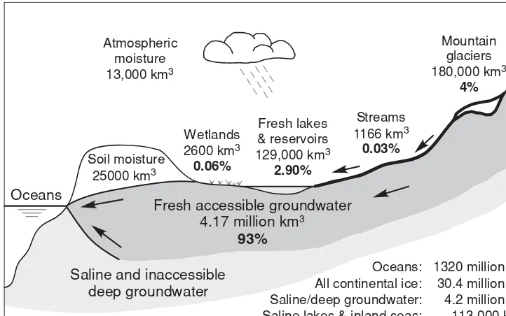
ground-water at depths greater than half a mile (800 m) is economically inaccessible at present or is saline. Thus, less than 3 percent of the world’s freshwater supply is available on the continents, and only little more than 11 percent of the water on the continents, actually is usable or accessible. Furthermore, the yearly renewal and continued availability of this relatively minute supply of water depend wholly on precipitation from a tenuous bit of water vapor in the atmosphere (Nace, 1960). Figure 1.1 shows volumes and percentage of usable freshwater types on the continents outside polar regions.
Mountain
Oceans: 1320 million km3 All continental ice: 30.4 million km3 Saline/deep groundwater: 4.2 million km3 Saline lakes & inland seas: 113,000 km3
FIGURE1.1 Volumes, in cubic kilometers, and percentages of usable freshwater on the continents outside polar regions. (Data from Nace, 1960; Groombridge and Jenkins, 1998; UNEP, 2007.)
snow. The estimated volume of moisture in the atmosphere is equivalent to only about 3100 mi3(13,000 km3) of water, or enough to cover the entire earth to a depth of only
about 1 in. (2.5 cm; Nace, 1960).
Of about 50 million mi2(130 million km2) of continental and insular dry land,
some-what more than 18 million mi2(about 36 percent) is arid to semiarid. Figure 1.2 shows
distribution of world’s nonpolar arid land. Such areas largely, or often entirely, depend on groundwater resources for irrigation and water supply.
Figure 1.3 is a photographic image of the Issaouane Erg (sand sea) located in eastern Algeria between the Tinrhert Plateau to the north and the Fadnoun Plateau to the south. Ergs are vast areas of moving sand with little to no vegetation cover. Part of the Sahara Desert, the Issaouane Erg covers an area of approximately 38,000 km2. These complex
dunes form the active southwestern border of the sand sea (NASA, 2007a). Because of prolonged droughts and desertification, in many places along the southern edge of the Sahara Desert, sand dunes advancement and rocky desert expansion are continuously taking place.
In the United States as a whole, the quantity of water in underground storage, within half a mile of the land surface, is several times that in all the large lakes of the North American Continent. Although the volume of groundwater in storage is large, its natural rate of replenishment is small in comparison. The following discussion by Nace (1960) illustrates this point:
Extremely arid Arid
Semiarid LEGEND
50O
THAR
TAKLIMAKAN
LUT KARA-KUM
ARABIAN
SOMALI-CHALABI
WESTERN SAHARA
KALAHARI
NAMIB
2000 miles
2000 kilometers 1000
0
1000 0
GREAT SANDY SIMPSON
PERUVIAN
ATACAMA
PATAGONIAN CHIHUAHUAN
30O
0O
30O
60O
SONORAN MOHAVE
GREAT BASIN
FIGURE1.2 Distribution of nonpolar arid land. (Source: Meigs, 1953.)
FIGURE1.3 Astronaut photograph of the Issaouane Erg (sand sea) located in eastern Algeria. The
photograph was acquired on January 16, 2005, with a Kodak 760C digital camera with an 800-mm lens, and is provided by the ISS Crew Earth Observations Experiment and the Image Science & Analysis Group, Johnson Space Center. (Available at http://earthobservatory.nasa.gov.)
which many hydrologists would dispute. However, it indicates the order of magnitude of groundwater recharge.
On the basis of the above estimates, the volume of ground water in storage above a depth of half a mile evidently is equivalent to the total of all recharge during the last 160 years. This estimate is very crude, but whether the true figure is 50, 100, or 200 years is unimportant. The significant fact is that a reserve of water has been accumulating in the groundwater bank for generations. This is the only real water reserve we have. Annual recharge in any one year is proportionately a very small increment to the total reserve. Now, by pumping, we are placing heavy drafts on the local “branch banks” in some parts of the United States—enough that the manager of the “main bank” must look to the total reserve and estimate how long the drafts can continue. This is the job for water management.
The southern high plains of Texas and New Mexico in the United States are an out-standing example of large storage and small replenishment. Overall, the groundwater in storage in the Texas region is about 200 million acre-ft (247 km3), but if exhausted it would take considerably more than 1000 years to replace (U.S. Senate Select Committee on National Water Resources, 1960, p. 15).
6
attempts of predictions for the future are made. Without immersing themselves into the heated political debate whom to blame for the climate change (nature, humans, or both), and what the consequences of doing (or not doing) something about it would be, wa-ter professionals are already facing the realities of redistribution of available freshwawa-ter on continents, on both local and global scales. Some of the better-known examples are reduction of snow pack in mountainous regions, melting of mountainous glaciers (Fig. 1.4), and shrinking of large natural lakes (Figs. 1.5 and 1.6). Popular and daily press are increasingly covering such phenomena. For example,National Geographic Newsfor Au-gust 3, 2007, offers this lead into a story: “Lake Superior, the world’s largest freshwater lake, has been shrinking for years – and now it appears to be getting hotter.” The article goes on to include some attention-grabbing narrative such as: “Beachgoers at the lake, which is bounded by Wisconsin, Michigan, Minnesota, and Ontario, Canada, must walk up to 300 feet (100 yards) farther to reach shorelines. Some docks are unusable because of low water, and once-submerged lake edges now grow tangles of tall wetland plants” and “Researchers are also starting to suspect that the shrinking and heating are related—and that both are spurred by rising global temperatures and a sustained local drought” (Mi-nard, 2007). More on climate change and its projected impacts on groundwater resources is given in Chapter 4. To set the stage, a short discussion on Aral Sea in Asia (Fig. 1.5) and Lake Chad in Africa (Fig. 1.6) illustrates the close interconnectedness of human activity, climate change, surface water and groundwater resources.
Once the fourth largest lake on earth, the Aral Sea has shrunk dramatically over the past few decades. The Aral Sea basin, covering the territories of Tajikistan, Uzbekistan, Turkmenistan, some parts of Afghanistan, Kyrgyzstan, and Kazakhstan, is located in the heart of the Euro-Asian continent. The two main rivers, the Amu-Darya and the Syr-Darya, together with some 30 primary tributaries, feed the basin, which has an areal extent of about 1.8 million km2. In the early 1960s, the former Soviet Union launched efforts to divert almost all water from the Amu-Darya and the Syr-Darya. The diversion of millions of cubic meters of water to irrigate cotton fields and rice paddies through mas-sive infrastructure development helped increase the irrigated area from 5 mha (million hectare) in the 1950s to 8 mha in the 1990s (Murray-Rust et al., 2003).
The water development system of the region is described as “one of the most com-plicated human water development systems in the world” (Raskin et al., 1992) because human interventions have gradually modified the natural water flow and the environ-ment along the rivers’ banks. The Aral Sea basin system now has highly regulated rivers with 20 medium- and large-sized reservoirs and around 60 diversion canals of different sizes. In all, the two rivers have some 50 dams of varying sizes (Murray-Rust et al., 2003). The large, slightly brackish inland sea moderated the region’s continental climate and supported a productive fishing industry. As recently as 1965, the Aral Sea received about 50 km3 of freshwater per year—a number that fell to zero by the early 1980s. Consequently, concentrations of salts and minerals began to rise in the shrinking body of water, eventually reaching 33 g/L, up from the initial 10 to 12 g/L. This change in chemistry has led to staggering alterations in the lake’s ecology, causing precipitous drops in the Aral Sea’s fish population and elimination of the commercial fishing industry (NASA, 2007b; Glazovsky, 1995).
FIGURE1.4 (Top) Photograph (northwest direction) taken several hundred meters up a steep
8
FIGURE1.5 Satellite images showing change in the Aral Sea size between 1989 (left image) and 2003 (right image). Once part of the same lake spread over 68,300 km2, the northern and southern half of the sea had already become virtually separated in 1989. The image at right shows the rapid retreat of the sea’s southern half, now separated into a western and eastern half. (Images from NASA, 2007b.)
summer. Recurrence of drought days increased by 300 percent. The last spring frosts shifted to later dates and the first autumn ones occur some 10 to 12 days earlier (Glazovsky, 1995). The shorter growing season is causing many farmers to switch from cotton to rice, which demands even more diverted water.
1987
Niger
Nigeria
1963 1973
Chad
1997 2001
Cameroon
LEGEND Water Vegetation Former shoreline
FIGURE1.6 Change in Lake Chad surface area between 1963 and 2001. (Maps are created from the series of satellite images taken in January each year and provided by the NASA Goddard Space Center. From UNEP/GRID-Arendal, 2002; maps by Phillippe Rekacewicz, UNEP/GRID-Arendal.)
Groundwater levels rose in many regions because of irrigation. For example, in the Tashauz region, land area with a groundwater level less than 2 m below ground surface was 20 percent from 1959 to 1964, whereas from 1978 to 1982 this area increased to 31.5 percent. Over the whole of Turkmenia, 87 percent of the irrigated land has groundwater levels that have risen by at least 2.5 m. Because of this rise in groundwater levels, the area subject to soil salinization due to evaporation from a shallow water table has dramatically increased in many regions. In contrast, as the levels of the Aral Sea and the inflowing rivers dropped, the adjacent and the nonirrigated areas subject to desertification experienced a decrease in groundwater levels by 10 to 15 m (Glazovsky, 1995).
10
Although Lake Chad is a closed-basin, shallow lake in a semiarid region (annual precipitation of about 30 cm) with a high evaporation rate (200 cm/yr), and therefore expected to have highly alkaline and saline waters, its water is surprisingly fresh (120 to 320 mg/L; Isiorho and Matisoff, 1990). This has been attributed to several factors: low volume-to-surface ratio that ensures significant dilution by rainfall, low salinities of the input rivers (42 to 60 mg/L), seepage through the lake bottom to the phreatic (unconfined) aquifer, and biogeochemical regulations (Isiorho and Matisoff, 1990).
The upper zone of the Chad formation, consisting of Quaternary sediments, is gen-erally unconfined and is recharged by the lake through seepage. The lake is at a higher hydraulic elevation than the aquifer, and field investigations, including direct seepage measurements, confirm groundwater flow away from the lake toward the southwest (Isiorho and Matisoff, 1990). The unconfined aquifer is tapped mostly by hand-dug wells for irrigation and domestic use throughout the southwest portion of the Chad Basin. It is this portion of the basin that would be affected by the possible disappearance of Lake Chad and an ultimate cessation of most of the aquifer recharge if current practices continue. This would lead to severe water shortages for the rural population depending upon shallow wells as well as water shortages over a huge land area already suffering from natural and social disasters.
1.2 Freshwater Availability
Efforts to characterize the volume of water naturally available to a given nation have been ongoing for several decades. The primary input for many of these estimates is an informa-tion database (AQUASTAT) that has historically been developed and maintained by FAO (Food and Agriculture Organization of the United Nations). It is based on data related to the quantity of water resources and uses a water-balance approach for each nation (FAO, 2003). This database has become a common reference tool used to estimate each nation’s renewable water resources. The FAO has compiled an index of Total Actual Renewable Water Resources (TARWR). This index reflects the water resources theoretically available for development from all sources within a country. It is a calculated volume expressed in km3/yr; divided by the nation’s population and adjusted to m3/yr, it is expressed as a per capita volume, which allows a relative evaluation of the resource available to its inhabitants. The index estimates the total available water resources per person in each nation, taking into account a number of individual component indicators by
r Adding all internally generated surface water annual runoff and groundwater recharge derived from precipitation falling within the nation’s boundaries
r Adding external flow entering from other nations, which contributes to both surface water and groundwater
r Subtracting any potential resource volumes shared by the same water, which comes from surface and groundwater system interactions
r Subtracting, where one or more treaty exists, any flow volume required by that treaty to leave the country (FAO, 2003; FAO-AQUASTAT, 2007)
are maximum theoretical volumes of water renewed annually as surface water runoff and groundwater recharge, taking into consideration what is shared in both the surface and groundwater settings. However, as discussed by UNESCO (2006), these volumes do not factor in the socioeconomic criteria that are potentially and differentially applied by societies, nations, or regions to develop those resources. Costs can vary considerably when developing different water sources. Therefore, whatever the reported “actual” re-newable volume of water, it is a theoretical maximum, and the extent to which it can be developed will be less for a variety of economic and technical reasons. Following are some of the factors that should be considered when using the TARWR index (UNESCO, 2006):
r Approximately 27 percent of the world’s surface water runoff occurs as floods, and this water is not considered a usable resource. However, floods are counted in the nation’s TARWR as part of the available, renewable annual water resource.
r Seasonal variability in precipitation, runoff, and recharge, which is important to regional and basin-level decision making and water storage strategies, is not well reflected in annualized quantities.
r Many large countries have several climatic regions as well as disparate popula-tion concentrapopula-tions and the TARWR does not reflect the ranges of these factors that can occur within nations.
r There is no data in TARWR that identifies the volume of “green” water that sustains ecosystems—the volume that provides water resources for direct rain-fed agriculture, grazing, grasslands, and forests.
As already indicated, not all of the internally renewable freshwater resources (IRWR) can be controlled by the population of a country. It is estimated that even with the most feasible technical, social, environmental, and economic means, only about one-third of the IRWR can be potentially controlled. The global potentially useable water resources (PUWR) of the IRWR are estimated to be around 9000 to 14,000 km3 (UN, 1999; Seckler, 1993). At present, about 2370 km3of the global PUWR are developed and are being diverted as the primary water supply (PWS) or the “virgin” or the “first” water supply for human use (IWMI, 2000). A part of the PWS is evaporated in its first use. The other part returns to rivers, streams, and aquifers as return flows and in many instances this part is again withdrawn for human use. This is known as the recycled portion of PWS. The PWS and the recycled water supply, about 3300 km3, constitute the water diverted for use in different sectors (agriculture, industry, public supply).
1.3 Water Use—Trends and Examples
12
water, is that part of water withdrawn that is evaporated, transpired by plants, incorpo-rated into products or crops, consumed by humans or livestock, or otherwise removed from the immediate water environment (USGS, 2007b). It is very important to make dis-tinction between water withdrawal and water consumption during resource evaluation. For example, not all water withdrawn for irrigation purpose and applied to a farmland will be consumed. Depending on the irrigation method, more or less diverted water will return to its original source or another body of water (e.g., surface streams and aquifers) because of drainage, runoff, and infiltration. This portion of the withdrawn water, called return flow, becomes available for further use.
The following is a list of terms commonly used by the water industry and regulators in the United States (USGS, 2007b; USEPA, 2007b):
Public supply.Water withdrawn by public governments and agencies, such as a county water department, and by private companies, which is then delivered to users. Public suppliers provide water for domestic, commercial, thermoelectric power, industrial, and public water users. Most household water is delivered by a public water supplier. Municipal (public) water system.A water system that has at least five service connections (such as households, businesses, or schools) or which regularly serves 25 individuals for at least 60 days out of the year.
Water supply system.The collection, treatment, storage, and distribution of potable water from source to consumer.
Water purveyor. A public utility, mutual water company (including privately owned), county water district, or municipality that delivers drinking water to customers. Potable water.Water that is safe for drinking and cooking.
Water quality criteria.Levels of water quality expected to render a body of water suitable for its designated use. Criteria are based on specific levels of pollutants that would make the water harmful if used for drinking, swimming, farming, fish production, or industrial processes.
Water quality standards.State-adopted and EPA-approved ambient standards for water bodies. The standards prescribe the use of the water body and establish the water quality criteria that must be met to protect designated uses.
Public water use.Water supplied from a public water supply and used for such purposes as firefighting, street washing, and municipal parks and swimming pools.
Domestic water use.Water used for household purposes, such as drinking, food prepara-tion, bathing, washing clothes, dishes, and pets, flushing toilets, and watering lawns and gardens. About 85 percent of domestic water is delivered to homes by a public-supply facility, such as a county water department. About 15 percent of the nation’s population supply their own water, mainly from wells.
Commercial water use.Water used for motels, hotels, restaurants, office buildings, other commercial facilities, and institutions. Water for commercial uses comes both from public-supplied sources, such as a county water department, and self-supplied sources, such as local wells.
Irrigation water use.Water application on lands to assist in growing crops and pastures or to maintain vegetative growth in recreational lands, such as parks and golf courses. Livestock water use.Water used for livestock watering, feedlots, dairy operations, fish
farming, and other on-farm needs.
Sanitation.Control of physical factors in the human environment that could harm devel-opment, health, or survival.
Sanitary water (also known as gray water).Water discharged from sinks, showers, kitchens, or other nonindustrial operations, but not from commodes.
Wastewater.The spent or used water from a home, community, farm, or industry that contains dissolved or suspended matter.
Water pollution.The presence in water of enough harmful or objectionable material to damage the water’s quality.
Treated wastewater.Wastewater that has been subjected to one or more physical, chemical, and biological processes to reduce its potential of being health hazard.
Reclaimed wastewater.Treated wastewater that can be used for beneficial purposes, such as irrigating certain plants.
Publicly owned treatment works (POTWs).A waste-treatment works owned by a state, unit of local government, or Indian tribe, usually designed to treat domestic wastewaters. Wastewater infrastructure.The plan or network for the collection, treatment, and disposal of sewage in a community. The level of treatment will depend on the size of the com-munity, the type of discharge, and/or the designated use of the receiving water.
Groundwater, with 93 percent of the total, is by far the most abundant and readily available source of freshwater on continents outside polar regions, followed by moun-tainous ice caps and glaciers, lakes, reservoirs, wetlands, and rivers (Fig. 1.1). About 1.5 billion people depended upon groundwater for their drinking water supply at the end of the twentieth century (WRI, 1998). The amount of groundwater withdrawn an-nually is roughly estimated at about 20 percent of global water withdrawals (WMO, 1997).
According to the United Nations Environment Programme (UNEP), annual global freshwater withdrawal has grown from 3790 km3(of which consumption accounted for 2070 km3or 61 percent) in 1995 to about 4430 km3(of which consumption accounted for 2304 km3or 52 percent) in 2000. In 2000, about 57 percent of the world’s freshwater with-drawal, and 70 percent of its consumption, took place in Asia, where the world’s major irrigated lands are located. In the future, annual global water withdrawal is expected to grow by about 10 to 12 percent every 10 years, reaching approximately 5240 km3by year 2025 (an increase of 1.38 times since 1995). Water consumption is expected to grow at a slower rate of 1.33 times. In the coming decades, the water withdrawal is projected to increase by 1.5 to 1.6 times in Africa and South America, while the smallest increase of 1.2 times is expected to occur in Europe and North America (UNEP, 2007; Harrison et al., 2001; Shiklomanov, 1999).
14
areas are projected to reach about 330 mha, up from approximately 253 mha in 1995 (Shiklomanov, 1999).
Industrial uses account for about 20 percent of global freshwater withdrawals. Of this, 57 to 69 percent is used for hydropower and nuclear power generation, 30 to 40 percent for industrial processes, and 0.5 to 3 percent for thermal power generation (Shik-lomanov, 1999). In the industrial sector, the biggest share of freshwater is stored in arti-ficial reservoirs for electrical power generation and irrigation. However, the volume of water evaporated from reservoirs is estimated to exceed the combined freshwater needs of industry and domestic consumption. This greatly contributes to water losses around the world, especially in the hot tropical and arid regions.
Domestic water supply accounted for about 13 percent of global water withdrawal in year 2000. Domestic water use in developed countries is on average about 10 times more than in developing countries. UNESCO estimates that on average a person in developed countries uses 500 to 800 L/d (300 m3/yr) for all purposes compared to 60 to 150 L/d (20 m3/yr) in developing countries. In developing countries of Asia, Africa, and Latin America, public water withdrawal represents just 50 to 100 L/person/d. In regions with insufficient water resources, this figure may be as low as 20 to 60 L/d. In large cities with a centralized water supply and an efficient canalization system, domestic consumption does not usually represent more than 5 to 10 percent of the total water withdrawal (UNEP, 2007).
In most regions of the world, the annual withdrawal or use of water is a relatively small part (less than 20 percent) of the total annual internally renewable water resources (Table 1.1). However, in water-scarce regions, as in the case of the Middle East and North Africa, this share averages 73 percent of the total water resources (Pereira et al., 2002; from The World Bank, 1992). The relevance of the problems of water scarcity is made clear when considering that estimates for the average annual growth of the population are the world’s highest in the same regions (Table 1.2).
Agriculture has the highest share among water user sectors in low- and middle-income countries, while industry is the most important user in developed countries with temperate and humid climates.
Water supply and sanitation face different problems in urban and rural settings. At present, more than one-third of the rural population is estimated to have no access to safe drinking water supply and a significant number of people do not have access to the minimum required levels (The World Bank, 2000; WRI, 1998). Moreover, almost 80 percent of the rural population is estimated to have no access to adequate sanitation, totaling 1.3 billion people in rural India and China alone (UNESCO-WWAP, 2003). This means that about 1.8 billion people in rural areas have yet to receive new and increased domestic water supply and sanitation facilities over the next few decades, which will require substantial increases in domestic withdrawals.
Internal Annual as a Share of Internal as a Share of Total Water
Renewable Water Total Water Renewable Resources
Water Withdrawal Resources Water Agriculture Domestic Industry
Country Group Resources (106m3) (106 m3) (%) Resources (m3) (%) (%) (%)
Low and middle income 28,002 1,749 6 6,732 85 7 8
Sub-Saharan Africa 3,713 55 1 7,488 88 8 3
East Asia and Pacific 7,915 631 8 5,009 86 6 8
South Asia 4,895 569 12 4,236 94 2 3
Europe 574 110 19 2,865 45 14 42
Middle East and North 276 202 73 1,071 89 6 5
Africa
Latin America and the 10,579 173 2 24,390 72 16 11
Caribbean
High income 8,368 893 11 10,528 39 14 47
OECD members 8,365 889 11 10,781 39 14 47
Other 4 4 119 186 67 22 12
World 40,856 3,017 7 7,744 69 9 22
From Pereira et al., 2002; source of data: The World Bank, 1992.
TABLE1.1 World Availability of Water Resources
Population (Millions) Average Annual Growth (Percent)
Country Group 1973 1980 1990 2000 2030 1965–73 1973–80 1980–90 1990–00 2000–30
Low and middle income 2,923 3,383 4,146 4,981 7,441 2.5 2.1 2.0 1.9 1.4
Sub-Saharan Africa 302 366 495 668 1,346 2.7 2.8 3.1 3.0 2.4
East Asia and Pacific 1,195 1,347 1,577 1,818 2,378 2.6 1.7 1.6 1.4 0.9
South Asia 781 919 1,148 1,377 1,978 2.4 2.4 2.2 1.8 1.1
Europe 167 182 200 217 258 1.1 1.2 1.0 0.8 0.6
Middle East and 154 189 256 341 674 2.7 3.0 3.1 2.9 2.3
North Africa
Latin America and the 299 352 433 516 731 2.6 2.4 2.1 1.8 1.2
Caribbean
High income 726 766 816 859 919 1.0 0.8 0.6 0.5 0.2
OECD members 698 733 111 814 863 0.9 0.7 0.6 0.5 0.2
World 3,924 4,443 5,284 6,185 8,869 2.1 1.8 1.7 1.6 1.2
From Pereira et al., 2002; source of data: The World Bank, 1992.
9.6 percent of the world’s urban population, accounting for slightly more than 374 million people (UN HABITAT, 2003). Growing slums and informal settlements surround most of the megacities and other large cities in the developing countries, which are of particular concern. There is widespread water and environmental contamination from human waste in these areas because of lack of adequate drinking water supplies, sanitation, and sewage treatment services (CSD, 2004). At the beginning of the twenty-first century, an estimated 924 million people lived in slums around the world (UN HABITAT, 2003).
International Water Management Institute (IWMI) projects, under one scenario, that most developing regions will more than double their water withdrawals for domestic and industrial uses between years 1995 and 2025. Except for the African region, this level of increase would ensure an average per capita domestic supply above the basic water requirement (BWR) of 50 L/person/d. The BWR is the recommended volume of water, independent of climate, technology, and culture, needed to satisfy domestic needs— drinking, sanitation, bathing, and cooking (Gleick, 1996). In Africa, however, per capita domestic water withdrawals at present are significantly below the BWR. To raise average per capita domestic supply even to the level of BWR, Africa will have to increase its total domestic water supply by 140 percent (Molden et al., 2001).
The world’s rural population is projected to grow at a slower rate over the coming decades, due to rapid urbanization and industrialization, particularly in developing countries. However, the rural population in Africa (AFR), South Asia (SA), and Middle East and North Africa (MENA) regions is projected to grow by 56 percent, 18 percent, and 20 percent, respectively. At the same time, the rural population in the East Asia and Pacific (EAP), Latin America and the Caribbean (LAC), and Europe and Central Asia (ECA) regions is projected to decline by 12 percent, 4 percent, and 27 percent, respectively. Even with the assumed slow growth in the overall rural population, more than 3.3 billion people are projected to live in rural areas by 2025, with more than 90 percent of them in South Asia, EAP, Africa, and the MENA regions (Molden et al., 2001).
Despite the expected large growth in water withdrawals for the domestic and in-dustrial sectors, agriculture will still remain the dominant water user in developing countries. The level of water use in the agricultural sector will be influenced by goals of self-sufficiency and food security at local, regional, and national levels. In the past, food self-sufficiency has been the major goal of most developing countries. This has helped developing countries increase food production, improve overall food availability for ru-ral households, and reduce ruru-ral unemployment and has had overu-rall positive effects in terms of reducing poverty (Molden et al., 2001).
1.3.1
Use of Water in the United States
18
1950 1955 1960 1965 1970 1975 1980 1985 1990 1995 2000
Groundwater Surface water Total
Population
FIGURE1.7 Trends in population and freshwater withdrawals by source, 1950–2000. (From Hutson et al., 2004.)
About 195 Bgal/d, or 48 percent, of all freshwater and saline water withdrawals during 2000 were used for thermoelectric power. Most of this water was derived from surface water and used for once-through cooling at power plants. About 52 percent of fresh surface water withdrawals and about 96 percent of saline water withdrawals were for thermoelectric power use. Withdrawals for thermoelectric power have been relatively stable since 1985.
1950 1955 1960 1965 1970 1975 1980 1985 1990 1995 2000
FIGURE1.9 Distribution of irrigated land in farms. One dot represents 5000 irrigated acres. (From Gollehon and Quinby, 2006.)
Irrigation remained the largest use of freshwater in the United States and totaled 137 Bgal/d for 2000. Since 1950, irrigation has accounted for about 65 percent of total water withdrawals, excluding those for thermoelectric power. Historically, more surface water than groundwater has been used for irrigation. However, the percentage of total irrigation withdrawals from groundwater has continued to increase—from 23 percent in 1950 to 42 percent in 2000. Total irrigation withdrawals were 2 percent more in 2000 compared to that in 1995 because of a 16 percent increase in groundwater withdrawals and a small decrease in surface water withdrawals. Irrigated acreage more than doubled between 1950 and 1980, then remained constant before increasing nearly 7 percent between 1995 and 2000 in response to drought in some states, especially in the southwest. In recent years, national irrigated area reached a plateau at about 55 million acres as the continuing growth in eastern states has been offset by declines in western irrigation. The number of acres irrigated with sprinkler and microirrigation systems has continued to increase and now comprises more than one-half the total irrigated acreage in the United States (Hutson et al., 2004).
Components of Source of
Agricultural Water Agricultural Agricultural
Withdrawals Withdrawals Withdrawals
Percent of Quantity (1000 Livestock
Number Total Acre-Feet and Ground Surface
Region Share of States Withdrawals (%) Per Year) Irrigation (%) Aquaculture (%) Water (%) Water (%)
Pacific 5 80 45,879 98 2 34 66
Mountain 8 91 64,209 96 4 20 80
Plains 6 49 25,901 97 3 80 20
South 7 30 19,054 95 5 73 27
North-Central & East 24 3 4,409 81 19 72 28
U.S. total1 50 41 159,558 96 4 41 59
1Excludes water withdrawals in the U.S. Virgin Islands, Puerto Rico, and the District of Columbia.
From Gollehen and Quinby, 2006.
WA
FIGURE1.10 Estimated percentage of population in a state using groundwater as drinking water in 1995. (From USGS, 1998.)
region, more than 90 percent of the water withdrawn is used by agriculture, almost all (96 percent) for irrigation.
Public supply withdrawals were more than 43 Bgal/d in 2000. Public supply with-drawals during 1950 were 14 Bgal/d. During 2000, about 85 percent of the population in the United States obtained drinking water from public suppliers, compared to 62 per-cent during 1950. The perper-centage of groundwater use for public supply increased from 26 percent in 1950 to 40 percent in 1985 and has remained at slightly less than 40 percent since (Hutson et al., 2004). Figure 1.10 shows that groundwater is an important source of drinking water for every state.
According to the USEPA 2001 data on public water supply for federal fiscal 2001 year, the total population served by community and noncommunity water systems using groundwater as the primary water source was 101,820,639 (Williams and Fenske, 2004). The total number of such water systems was 150,793. Sixteen states had more than 1000 systems, and all but one had more than 100 systems (Rhode Island had 59). Twenty-six states had more than 1 million population served by public water systems using mostly groundwater, with the top five being Florida (>14 million), California (>9 million), Texas (>7 million), New York (>5 million), and Michigan (>3 million). Ten additional states had more or very close to three million population served primarily by groundwater: Illinois, Indiana, Louisiana, Minnesota, Mississippi, New Jersey, Ohio, Pennsylvania, Washington, and Wisconsin.
The estimated withdrawals for self-supplied domestic use increased by 71 percent between 1950 and 2000. The self-supplied domestic population was 57.5 million people for 1950, or 38 percent of the total population. During 2000, 43.5 million people, or 15 percent of the total population, were self-supplied (Hutson et al., 2004).
22
by 24 percent. Estimates of industrial water use in the United States were largest during the years from 1965 to 1980, but during 2000, estimates were at the lowest level since reporting began in 1950. Combined withdrawals for self-supplied domestic, livestock, aquaculture, and mining were less than 13 Bgal/d for 2000 and represented about 3 percent of total withdrawals.
California, Texas, and Florida accounted for one-fourth of all water withdrawals for 2000. States with the largest surface water withdrawals were California, which had large withdrawals for irrigation and thermoelectric power, and Texas, which had large withdrawals for thermoelectric power. States with the largest groundwater withdrawals were California, Texas, and Nebraska, all of which had large withdrawals for irrigation (Hutson et al., 2004).
Total withdrawals have remained about 80 percent surface water and 20 percent groundwater during the 1950 to 2000 period. The portion of surface water withdrawals that was saline increased from 7 percent in 1950 to 20 percent in 1975 and has remained about 20 percent since. The percentage of groundwater that was saline never exceeded about 2 percent. The percentage of total withdrawals that was saline water increased from a minor amount in 1950 to as much as 17 percent during 1975 to 1990.
Water withdrawals are not the only measure of water use. Consumptive use—the water not returned to the immediate water environment—is much greater for agricul-ture than any other sector, both in total and as a share of water withdrawn. Estimates available from 1960 through 1995 show that agriculture accounts for more than 80 per-cent of the nation’s consumptive use because a high share of applied irrigation water is used by plants for evapotranspiration (building of biomass), with little returning to surface or groundwater. Water diverted for cooling thermoelectric plants tends to be used as a thermal sink, with much of it returned to rivers and streams. Greater irrigation withdrawals do not necessarily translate into greater consumptive use per irrigated acre. The difference between withdrawals and consumptive use highlights the importance of losses, runoff, and return flows (Gollehon and Quinby, 2006).
1.3.2
Use of Water in Europe
The principal source of extracted freshwater in Europe is surface water with the remain-der coming from groundwater sources and only minor contributions from desalination of seawater such as in Spain. According to a 1995 survey, of the total water abstracted in the European Union (EU), about 29 percent was groundwater (Krinner et al., 1999; from EEA, 1995). However, in many EU countries groundwater is the main source for public water supply because it is readily available and generally of high quality, resulting in the relative low cost of treatment and supply compared to surface water (Nixon et al., 2000; EEA, 1998). The proportion of groundwater use for public water supply in different EU countries is given in Table 1.4 (Krinner et al., 1999).
Country Surface Water Groundwater
Austria 0.7 99.3
Belgium
Brussels 100.0 0.0
Flanders 48.5 51.5
Denmark 0.0 100.0
Finland 44.4 55.6
France 43.6 56.4
Germany 28.0 72.0
Greece 50.0 50.0
Ireland 50.0 50.0
Italy 19.7 80.3
Luxembourg 31.0 69.0
Netherlands 31.8 68.2
Portugal 20.1 79.9
Spain 77.4 21.4
Sweden 51.0 49.0
United Kingdom 72.6 27.4
Norway 87.0 13.0
Iceland 15.9 84.1
Switzerland 17.4 82.6
Czech Republic 56.0 44.0
Simplified from Krinner et al., 1999.
TABLE1.4 Apportionment of Public Water Supply, in Percent, Between Groundwater and Surface Water
management, reducing losses, using water more efficiently, and recycling (Krinner et al., 1999).
The economic transition in central and eastern European countries during the 1990s had a large impact on water consumption in the region. The decrease in industrial ac-tivity, especially in water-intensive heavy industries, such as steel and mining, led to decreases of up to 70 percent in water extraction for industrial use. The amount of water extraction for agriculture also decreased by a similar percentage. Abstraction for public water supply declined by 30 percent after the fees were increased to reflect water costs and water meters were installed in houses (EEA, 2005).
On average, 37 percent of total water use in the EU countries is for agriculture, 33 percent for energy production (including cooling), 18 percent for urban use, and 12 per-cent for industry (excluding cooling). Total combined water withdrawal for agriculture remained almost unchanged over the period, while those for urban use and energy de-creased by 11 percent and for industry by 33 percent (EEA, 2005). Tourism, one of the fastest increasing socioeconomic activities in Europe, places severe, often seasonal, pres-sures on water resources, especially in southern Europe.
24
% Share of World Population Average Annual Per Population Density Capita Availability of
Region (as of 2001) (pop/km2) Water Resources (m3)
Africa 13 27 5,157
Asia 61 117 3,159
Europe 12 32 9,027
Latin America & the Caribbean 9 26 27,354
North America 5 15 16,801
Oceania 1 4 53,711
World — 45 7,113
From Vordzorgbe, 2003; source of data: UN, 2001.
TABLE1.5 Population and Water Resource Features of Regions of the World
Portugal, Italy, and Turkey, irrigation accounts for more than 60 percent of water use, a large share coming from groundwater extraction. In the more humid and temperate EU member countries irrigation is carried out mainly to complement natural rainfall, and its share of total water use is generally less than 10 percent (EEA, 2005).
1.3.3
Use of Water in Africa
Africa is home to about 13 percent of the world’s population, but has only about 9 percent of the world’s water resources (UNEP, 2002). Average annual per capita availability of water resources in Africa is lower than the world average and higher than that of only Asia (see Table 1.5). This low level of water availability in Africa is due to three basic factors (Vordzorgbe, 2003):
1.A significant decline in the average rainfall since the late 1960s. In recent times, most of the continent has experienced increased aridity as mean annual rainfall has reduced by 5 percent to 10 percent between 1931–1960 and 1968–1997. The decline in Sahelian rainfall has been the largest sustained decline recorded anywhere in the world since instrumental measurements began, while deviations from the trend have been larger than in other arid regions of the world.
2.Low runoff due to high evaporative losses. Total runoff as a percentage of precipitation is the lowest in the world, at about 20 percent, compared to 35 percent for South America and about 40 percent for Asia, Europe, and North America.
Only about 4 percent of the nearly 4 million km3of renewable water available annually is used in Africa. Except for the northern Africa, the total amount of water withdrawn in all other subregions for use in agriculture, public water supply, and industry show that at both continental and subregional levels the withdrawals are rather low in relation to both rainfall and internal renewable resources. This may reflect a low level of development and use of water resources in the continent. However, variability in rainfall results in frequent bouts of water scarcity and, during these times, demand exceeds supply (UN Water/Africa, 2006).
In 2000, because of inadequate water storage, processing, and distribution systems, about 36 percent of the population did not have access to potable water, but the depriva-tion is higher in rural areas, where as much as 50 percent lacked access to safe water. Also, because of low investment in water supply and distribution infrastructure, increasing demand and weak water management policies, access to water is highly skewed in favor of urban consumers and some agricultural and industrial users (Vordzorgbe, 2003).
It is estimated that more than 75 percent of the African population uses groundwater as the main source of drinking water supply. This is particularly so in North African countries, such as Libya, Tunisia, and parts of Algeria and Morocco, as well as in southern African countries, including Botswana, Namibia, and Zimbabwe. However, groundwater accounts for only about 5 percent of the continent’s total renewable water resources and the groundwater withdrawal is mainly from the nonrenewable aquifer storage. In South Africa, for example, groundwater accounts for only 9 percent of the renewable water (UN Water/Africa, 2006).
Owing to the highly variable levels of rainfall in Africa, large numbers of people are dependent on groundwater as their primary source of freshwater for various uses (UNEP, 2002). For example, in Libya and Algeria 95 percent and more than 60 percent of all withdrawals, respectively, are from groundwater. Algeria, Egypt, Libya, Mauritius, Morocco, South Africa, and Tunisia are increasingly looking at the use of desalinated water to assist in meeting their withdrawal requirements (UNEP, 2002).
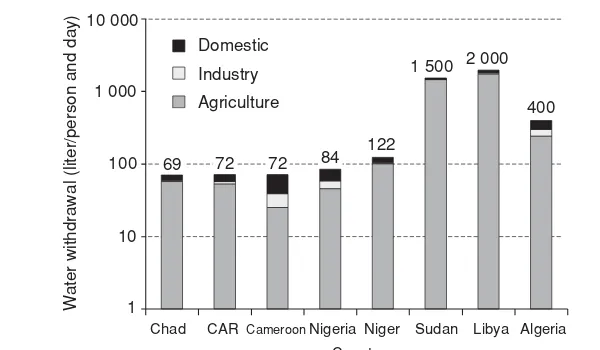
Water Use in Lake Chad Basin
Water uses in eight countries of the Lake Chad Basin are typical of nonindustrialized, undeveloped, and developing countries in Africa and around the world. The majority of freshwater consumed in the region is used for agriculture followed by domestic use (Fig. 1.11). In Africa, Nigeria is the sixth largest user of water by volume (4 billion m3/yr; Revenga and Cassar, 2002).
In the Sudan sector of the basin (West Darfur), more than 50 percent of water is obtained from dug wells with bucket collection (The World Bank, 2003). Women have to travel great distances in order to gather water for drinking, cooking, and other everyday activities. Reservoirs formed by the Tiga and Challawa Gorge dams of the Kano City Water Supply (KCWS) supply the large Nigerian urban centre of Kano City for domestic and industrial purposes (GIWA, 2004).
Traditional agriculture in the basin is predominantly rain-fed. The rivers in the Chari-Logone and Komadugu-Yobe subsystems support flood farming and recessional farm-ing. Farmers in downstream areas therefore depend largely on river flow because rainfall is low and variable. The many large irrigation projects are located predominantly in the Komadugu-Yobe Basin.
26
Chad CAR CameroonNigeria Niger Sudan Libya Algeria Country
Domestic
Industry Agriculture
FIGURE1.11 Freshwater withdrawal per person per day by economic sector in countries of the Chad Lake Basin, Africa. (From GIWA, 2004; source of data The World Bank, 2002.)
because of the recent declines in aquifer recharge due to prolonged droughts and reduc-tion in river flows, aquifers are currently vulnerable to overextracreduc-tion exceeding their safe yield. Surface water scarcity during these droughts as well as adaptation strategy increased the extraction of groundwater for human, agricultural, and pastoral purposes (GIWA, 2004; Thieme et al., 2005). There has been an indiscriminate drilling of wells that has led to a decrease in groundwater reserves. Groundwater drawdowns of several tens of meters have been reported in the Maiduguri area of Nigeria due to overpumping. Isiorho et al. (2000) estimate that 10 to 25 percent of water in the region is used ineffi-ciently and attempts to improve the situation have achieved little. The droughts of the 1980s triggered the mass drilling of 537 wells between 1985 and 1989. This rapid devel-opment resulted in unsatisfactory logging of wells by several contractors who were not supervised. Most of these deep wells are uncapped and free-flowing. Normally, the local authorities cap artesian wells, but local people uncap them and allow the water to flow out and cool so that their animals can use it. This free flow of water is very inefficient and results in vast amounts of water being lost due to the high rates of evaporation in the region (Isiorho et al., 2000). Water points at Ala near Marte (Nigeria), monitored on a routine basis by the Lake Chad Basin Commission, have shown a sharp decline of about 4.5 m within a period of 1 year attributable to the general decline in the artesian pressure within the basin. Most desert species have also disappeared due to the declining water table (GIWA, 2004).
1.3.4
Use of Water in China and India
100
1949 1959 1969 1979 1989 1999
Year
FIGURE1.12 Percentage of water use in China for agriculture, industry, and domestic water supply between 1949 and 2002. (Data from Jin et al., 2006; original data from the Ministry of Water Resources, and Liu and Chen, 2001.)
Total water use in China has increased fivefold since 1950s. It was 103 km3in 1949 and increased to about 550 km3 in recent years (Jin et al., 2006). As illustrated in Fig. 1.12, the percentage of water use in agriculture has decreased from 97 percent in 1949 to 68 percent in 2002, as domestic and industrial uses have substantially increased. In 2004, agricultural uses consumed about 359 billion m3(359 km3) of water, accounting for 65 percent of total national water use. Of this, some 323 km3, or 90 percent, went to farmland irrigation (Li, 2006).
China has experienced serious water shortages over the past two decades. According to a recent report on the country’s status of water resources funded by the Chinese Ministry of Science and Technology, water shortages in China cause direct economic losses averaging 280 billion yuan (35 billion U.S. dollars (USD)) each year, which is 2.5 times more than the loss caused by floods (Li, 2006). Reportedly, some 350 million people lack access to reliable water supply.
Recognizing the seriousness of water availability, use, and management, the Chinese government passed a new regulation in 2006, updating its system of use permits and stipulating charges for water consumption in agriculture. According to officials in the State Council (China’s parliament), this move is expected to enforce water-saving mea-sures in irrigation and motivate farmers to economize on water use. Improving water efficiency in agriculture is considered the most effective way to achieve significant water savings in China. Most of China’s fields use flood irrigation methods that can result in significant waste, with 1 ha of farmland typically requiring 20,000 to 30,000 m3of water a year (Li, 2006).
28
USD) in GDP, China uses three times more water than the world average. Only 60 to 65 percent of the water used by Chinese industries was recycled or reused in 2004, compared to 80 to 85 percent in most developed countries (Li, 2007).
Groundwater plays a key role in the China’s water supply. About 70 percent of drink-ing water and 40 percent of agricultural irrigation water come from groundwater (Zhan, 2006). Available groundwater, however, is not evenly distributed: about two-thirds are in the south and only one-third is in the semiarid north, where most of the agricultural irrigation is taking place. This has led to a dramatic groundwater overexploitation, par-ticularly in northern China (Hebei, Beijing, and Tianjin provinces). For example, actual groundwater abstraction in Hebei province in 1999 was 14.9 km3(including 2.2 km3of slightly brackish groundwater with total dissolved solids between 1 and 5 g/L), but its recharge of fresh groundwater is estimated at 13.2 km3and the allowable yield of fresh groundwater is only 9.95 km3/yr. This means that about 1.8 km3of fresh groundwater is overexploited every year (Jin et al., 2006).
Groundwater level depth for the deep freshwater in North China provinces was in the order of 20 to 100 m in 2001, but it was near the surface or artesian in the 1960s. Rates of groundwater level (hydraulic head) decrease for the deep confined freshwater aquifers are 1 to 2 m/yr. Cangzhou, a coastal city in eastern Hebei plain, is one of the cities with most serious hydraulic head decline of deep confined aquifers: 100 m (330 ft) since the 1960s. The hydraulic head decline has resulted in land subsidence, degradation of water quality, and increased costs of pumping (Jin et al., 2006).
A 2006 study by the Hebei Bureau of Hydrology and Water Resources Survey esti-mates that the shallow groundwater table in China’s central Hebei Plain, south of Beijing, will drop an additional 16.2 m (more than 50 ft) on average by 2030, while the hydraulic head in the confined aquifers will fall additional 39.9 m (more than 130 ft) on average. These projections are based on the ongoing rates of groundwater depletion in the vast area where groundwater accounts for 90 percent of the regional water supply. This se-vere groundwater ose-verexploitation has led to the shortfall between water supply and rapidly rising demands from agriculture, industry and urban residents, including two “megacities” Beijing and Tianjin, with a combined population of 26 million people (Liu, 2006).
According to the Indian Ministry of Water Resources, the total renewable ground-water resources of India have been estimated at about 433 billion m3(433 km3), whereas this volume for surface water is 690 km3 (Ministry of Water Resources, 2007a, 2007b). Table 1.6 shows that the total estimated renewable water resources (1123 km3) will not be sufficient to satisfy India’s projected water requirements of 1447 km3 in year 2050.
Year
Sector 2000 2025 2050
Domestic 42 73 102
Irrigation 541 910 1072
Industry 8 23 63
Energy 2 15 130
Other 41 72 80
Total 634 1093 1447
From Central Water Commission, 2007.
TABLE1.6 Estimated Annual Water Requirements in India for Different Uses, in Cubic Kilometers
Bank, 2005). It therefore appears that there is a discrepancy between the various estimates of current and future water requirements, the actual groundwater withdrawal, and the renewable groundwater availability.
Keeping a provision for about 71 km3/yr of groundwater for other uses, the Indian Government estimates that 361 km3/yr of groundwater is available for irrigation. The current net groundwater withdrawal for irrigation is estimated at 150 km3/yr (Ministry of Water Resources, 2007a), which is about 40 percent of the available renewable ground-water. Based on these numbers, it is estimated that India as a whole has about 211 km3of renewable groundwater resources available for additional growth in agriculture. Most projected water requirements in years 2025 and 2050 would therefore have to be met using the surface water and nonrenewable groundwater resources.
There are large differences in surface water and groundwater availability and utiliza-tion between regions of the country. Currently, there are 5723 groundwater assessment units (called blocks, mandals, or talukas), of which almost 30 percent are “nonsafe” in terms of groundwater extraction (i.e., the units are semicritical, critical, or overexploited). The number of overexploited and critical units is the highest in states of Andhra Pradesh, Delhi, Gujarat, Haryana, Karnataka, Punjab, Rajasthan, and Tamil Nadu (CGWB, 2006).
Recognizing the seriousness of water supply issues across the country, the Indian Government has planned and implemented various measures, including constitution of the Central Ground Water Authority with a mandate to regulate and control groundwater development and management. The ongoing activities include registration of “ground water structures” (e.g., water wells), registration of water well drilling agencies to de-velop a microlevel database on groundwater dede-velopment and to control indiscriminate drilling activity in the country, regulation of groundwater development by the industry, promotion of artificial aquifer recharge, and general education and outreach. In addi-tion, the Ministry of Water Resources is engaged in the planning and implementation of huge interbasin transfers of surface water aimed at curbing water shortages primarily for public water supply.
30
consultants, The World Bank (2005) warns that “India faces a turbulent water future. The current water development and management system is not sustainable: unless dramatic changes are made—and made soon—in the way in which government manages water, India will have neither the cash to maintain and build new infrastructure, nor the water required for the economy and for people.” World news media, following the report’s release, have been much less diplomatic, often including disturbing stories:
“There’s virtually no country in the world that lives with a system as bad as you have here,” John Briscoe, author of the Bank’s draft country report on India, told a media conference in New Delhi. (AFP, 2005)
“What has happened in the last 20 or 30 years is a shift to self-provision. Every farmer sinks a tubewell and every house in Delhi has a pump pumping groundwater,” said Briscoe, an expert on water issues at the World Bank. “Once that water stops you get into a situation where towns will not be able to function.” (AFP, 2005)
The report says that India has no proper water management system in place, its groundwater is disappearing and river bodies are turning into makeshift sewers. (AFP, 2005)
“Estimates reveal that by 2020, India’s demand for water will exceed all sources of supply,” the report says. “There is no question that the incidence and severity of conflicts (over water) has increased sharply in recent times. . .There is a high level of vitriol in the endemic clashes between states on inter-state water issues.” (AFP, 2005)
It is a rare morning when water trickles through the pipes. More often, not a drop will come. So Prasher will have to call a private water tanker, wait for it to show up, call again, wait some more and worry about whether there are enough buckets filled in the bathroom in case no water arrives. Prasher has the misfortune of living in a neighborhood on Delhi’s poorly served southern fringe. As the city’s water supply runs through an 8,960-kilometer network of battered public pipes, an estimated 25 to 40 percent leaks out. By the time it reaches Prasher, there is hardly enough. On average, she gets no more than 13 gallons a month from the tap and a water bill that fluctuates from $6 to $20, at its whimsy, she complains, since there is never a meter reading anyway. That means she has to look for other sources, scrimp and scavenge to meet her family’s water needs. She buys 265 gallons from private tankers, for about $20 a month. On top of that she pays $2.50 toward the worker who pipes water from a private tube-well she and other residents of her apartment block have installed in the courtyard.
Her well water has long turned salty. The water from the private tanker is mucky brown. Still, Prasher said, she can hardly afford to reject it. “Beggars can’t be choosers,” she said. “It’s water.” (Sengupta,The New York Times, 2006)
1.4 Water Scarcity
Water scarcity exists when the amount of water withdrawn from lakes, rivers, or ground-water is such that ground-water supplies are not adequate to satisfy all human or ecosystem requirements, resulting in increased competition between water users and demands. An area is under water stress when annual water supply is below 1700 m3(450 thousands gallons) per person. When annual water supply is below 1000 m3(264,000 gallons) per person, the population experiences water scarcity (UNEP, 2007).
water resources are unavailable or at best only marginally available for use in human and natural systems (Pereira et al., 2002).
Water scarcity may be permanent or temporary, may be caused by natural conditions (e.g., aridity, drought), or it may be human-induced (desertification, overexploitation of water resources). Worldwide, agriculture is the sector that has the highest demand for water. Because of its large water use, irrigated agriculture is often considered the main cause for water scarcity. Irrigation is accused of misuse of water, of producing excessive water wastes, and of degrading water quality. However, irrigated agriculture provides the livelihood of an enormous part of the world’s rural population and supplies a large portion of the world’s food (Pereira et al., 2002). Many countries also regard agricultural production as a matter of national security or geopolitical strategy, and thus support irrigation, including in desert areas where depletion of nonrenewable groundwater re-sources is the only option (Fig. 1.13).
Some 460 million people—more than 8 percent of the world’s population—live in countries using so much of their freshwater resources that they can be considered highly water stressed. A further 25 percent of the world’s population lives in countries ap-proaching a position of serious water stress (UNEP, 2007; UNCSD, 1999; WMO, 1997).
Many African countries are facing alarming water shortages, which will affect nearly 200 million people. By the year 2025, it is estimated that nearly 230 million Africans will be facing water scarcity and 460 million will live in water-stressed countries (Falkenmark, 1989). As discussed by Vordzorgbe (2003),
the future is not salutary: water stress will increase in Africa due to the influence of climate factors (increasing frequency of flood and drought and water system stress) and anthropogenic causes of increasing use (from rising population, expanding urbanization, increasing economic development, unplanned settlement patterns), inadequate storage and recycling, lack of knowledge to address concerns and weak governance of the water sector. Africa has the highest population growth rate and the fastest rate of increase in urban population in the world. This has implications for demand, quality and sustainability of water resources.
Because of the lack of renewable freshwater resources, Bahrain, Kuwait, Saudi Arabia, and the United Arab Emirates have resorted to the desalinization of seawater from the Gulf. Bahrain has virtually no freshwater (Riviere, 1989). Three-quarters of Saudi Arabia’s freshwater comes from nonrenewable groundwater, which is reportedly being depleted at an average of 5.2 km3/yr (Postel, 1997). Lester Brown, in his bookPlan B 2.0 Rescuing
a Planet Under Stress and a Civilization in Trouble(2006) writes: “When the Saudis turned to their large fossil aquifer for irrigation, wheat production climbed from 140,000 tons in 1980 to 4.1 million tons in 1992. But with rapid depletion of the aquifer, production dropped to 1.6 million tons in 2004. It is only a matter of time until irrigated wheat production ends.”
32
FIGURE1.13 Satellite image showing area of Jabal Tuwayq, southwest of Riyadh in Saudi Arabia. Circles are fields with center-pivot irrigation systems, drawing groundwater via drilled wells in the centers. The diameter of circular fields varies from several hundred feet (tens of meters) to over a mile (2 km). (Space Shuttle astronaut photograph number STS032-096-032 taken in January 1990. Image courtesy of the Image Science & Analysis Laboratory, NASA Johnson Space Center; http://eol.jsc.nasa.gov.)
UNFPA, 1997). The numbers do not imply that the billions of people living in these coun-tries will be without water. What they do imply, however, is that these 54 councoun-tries will most likely encounter serious constraints in their capacity to meet the demands of indi-vidual people and businesses, agriculture, industry, and the environment. Meeting these demands will require extensive planning and careful management of water supplies (CSIS and Sandia Environmental Laboratories, 2005).
1. Physical water scarcity is defined in terms of the magnitude of primary water supply (PWS) development with respect to potentially utilizable water resources (PUWR). The physical water scarce condition is reached if the PWS of a country exceeds 60 percent of its PUWR. This means that even with the highest feasible efficiency and productivity, the PUWR of a country is not sufficient to meet the demands of agriculture, domestic, and industrial sectors while satisfying its environmental needs. Countries in this category will have to transfer water from agriculture to other sectors and import food or invest in costly desalinization plants.
2. Economic water scarcity is present in countries that have sufficient water re-sources to meet their additional PWS needs, but they require increasing their PWS through additional storage and distribution systems by more than 25 per-cent. Most of these countries face severe problems related to both finance and the capacity for development for increasing PWS to those levels.
3. The third category includes countries with little or no water scarcity. These coun-tries are not physically water scarce but need to develop less than 25 percent of additional PWS to meet their 2025 needs.
Although an individual country may face physical water scarcity as a whole, substan-tial variations can exist within the country. For example, half of the Indian population lives in the arid northwest and southeast where groundwater is seriously overexploited, while the other half lives in regions with more abundant water resources. Substantial variations also exist between north and south China. Some parts of Mexico are physi-cally water scarce, while others are not (Barker et al., 2000). Another important aspect is temporal variation. Some countries, especially those in monsoonal Asia, receive most of their rainfall in a few months in the wet season. These countries face severe water-scarce conditions in the other period of the year (Molden et al., 2001; Amarasinghe et al., 1999; Barker et al., 2000).
Researchers at Keele University, Great Britain, have developed the Water Poverty Index (WPI) as an interdisciplinary measure that links household welfare with water availability and indicates the degree to which water scarcity impacts on human popu-lations (Lawrence at al., 2002). Such an index makes it possible to rank countries and communities within countries taking into account both physical and socioeconomic fac-tors associated with water scarcity. This enables national and international organizations concerned with water provision and management to monitor both the resources available and the socioeconomic factors that have impact on access and use of those resources.
As argued by Lawrence et al. (2002), there is a strong link between “water poverty” and “income poverty” (Sullivan, 2002). A lack of adequate and reliable water supplies leads to low levels of output and health. Even where water supply is adequate and reliable, people’s income may be too low to pay the user costs of clean water and drive them to use inadequate and unreliable sources of water supply. This fact was one of the drivers behind developing the WPI. The index encompasses five components: