EVACUATION ROUTE MAPPING AGAINST SLAMET VOLCANO DISASTER AT
GUNUNGSARI VILLAGE, PULOSARI SUB DISTRICT, PEMALANG DISTRICT
Misdiyanto
Regional Development and Planning Department, Pemalang Email: [email protected]
Djoko Legono
Civil and Environmental Engineering Department, Faculty of Engineering, Gadjah Mada University, Yogyakarta Email: [email protected]
Subagyo Pramumijoyo
Geological Engineering Department, Faculty of Engineering, Gadjah Mada University, Yogyakarta Email: [email protected]
ABSTRACT
Villages inside the hazard zone of Slamet Volcano should have an evacuation map, as an anticipation and guidance to guide people evacuate when volcanic activity on the area arise to dangerous level. The experience which occurred at 2009 and 2010 indicate the necessity of the development of evacuation map for 7 villages inside the hazard zone in the Pemalang residential district, such as village of Gunung Sari. The main purpose of the developing an evacuation map is to make the village of Gunung sari becoming more vigilant to anticipate the danger of Slamet Mount eruption. Qualitative methods were used in this study, by handing out preliminary questionnaire to investigate the characteristic of the residents. The development of evacuation map also relies on the participation of the residents, then the resulted map were evaluated by assessing how far people can understand and comprehend any information provided on the map. The result of the investigation shows that Gunungsari’s resident wants an evacuation map, shown by high enthusiasm on the questions of the necessity of an evacuation map and disaster preparedness team that is equal to 97% of the residents on Dusun Sipendil, 83% on dusun Sibedil, 67% on Dusun Silegok, and 63% on Dusun Krajan. The residents also understand and comprehend the information provided on the map nicely, especially about the timing and rendezvous location for the evacuation. It is indicated by high proportion of residents that answer the questions asked accurately, which is 100% on Dusun Sipendil, 97% on Dusun Sibedil, and 80% for both Dusun Silegok and Dusun Krajan.
Keywords
: disaster prone area, evacuation map, society characteristic1 INTRODUCTION
Slamet Volcano is located in Central Java Province which is administratively located among 5 districts namely Pemalang, Tegal, Brebes, Banyumas and Purbalingga. In the period of April to June 2009, volcanic activity of Slamet Volcano increased so that its status was raised from Normal (Level I) to Caution (Level II), then Warning (Level III), while from late June to early 2010 it was on Caution status (Level II). Since July 1st, 2011 until now, the activity of Slamet
Volcano has turned back to Normal level (Anonymous, 2009).
There are seven villages in Pemalang District which are included into KRB (Disaster Prone Regions) of Slamet Volcano with the danger level is relatively the same that was in KRB Area I (Table 1), as shown in Slamet Volcano Disaster Prone Regions Map published by the Center of Volcanology and Geological Hazard Mitigation as the most competent part. It was also as stated on Fixed Procedure on Disaster Management
No:02/BENCAL/PML/2009 (Suhadi and Deddy, 2007).
The main danger encountered by villages within the range of KRB Slamet Volcano in Pemalang District is lahar flow. The expansion of lava flows and hot clouds may threat as well if the eruption is severe. Gunungsari village characterized as the highest number of population among other villages which are located in KRB of Slamet Volcano in Pemalang, and traversed by several rivers should be prioritized in mapping evacuation route.
map prepared is to lead the people from their home to the evacuation point at each sub village as defined in Protap/02/BENCAL/PML/2009 (Suhadi and Deddy, 2007).
2 LITERATURE REVIEW
Volcano has a complex definition. It is such kind of observed obviously. The flow of lava from the summit crater or side crater, hot cloud, rock flow, lava eruption,
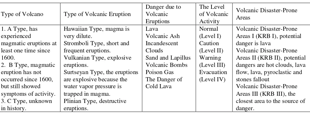
and so on indicates that the volcano is still active. Usually, the morphology of the active volcano is the generated perfect cone formation (Alzwar M., et al, 1987). Some classification and characteristics related to volcano can be seen in Table 1.
The history of Slamet Volcano eruption is the eruptive period ranging between 1 and 53 years, after the eruption in 1772, the next eruption was occurred again in 1825. After the 1825 eruption, frequency of the occurrence was more often that was in 1835, 1849, 1860, 1875, 1885 and 1904. Started in 1923, the erruption happened more frequent. The last eruption \was occurred in the midyear of 2009 in which turned to be warning status within around 1.5 months.
Table 1. Classification and characteristic of volcano Type of Volcano Type of Volcanic Eruption
Danger due to
magmatic eruptions at least one time since 1600.
2. B Type, magmatic eruption has not occurred since 1600, but still showed symptoms of activity. 3. C Type, unknown in history.
Hawaiian Type, magma is very dilute.
Stromboli Type, short and frequent eruptions. Vulkanian Type, explosive eruptions.
Surtseyan Type, the eruptions are explosive because the water vapor pressure is trapped in magma. Plinian Type, destructive eruptions.
Lava
Volcanic Ash Incandescent Clouds
Sand and Lapillus Volcanic Bombs Areas I (KRB I), potential danger is lava
Volcanic Disaster-Prone Areas II (KRB II), potential dangers are hot clouds, lava flow, lava, pyroclastic and stones fallout
Volcanic Disaster-Prone Areas III (KRB III), the closest area to the source of danger.
3 METHOD
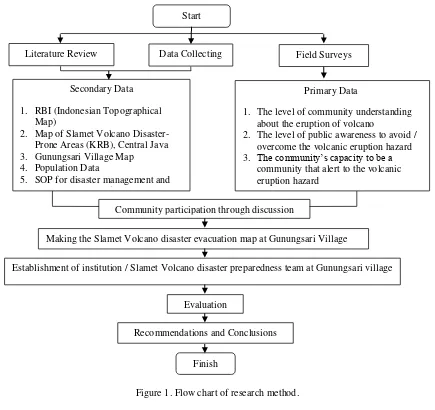
The sequence steps of evacuation route mapping against Slamet Volcano eruption disaster at Gunungsari Village, Pulosari Sub District, Pemalang District can be seen in the flow chart as shown in Figure 1.
4 PRELIMINARY AND EVALUATION
QUESTIONNAIRE
Evacuation route mapping at Gunungsari Village involved community participation. It was conducted in each sub village including Sipendil, Sibedil, Silegok and Krajan Sub Village. Before and after mapping the evacuation route, questionnaires were given to villagers in order to find out how far their understanding/comprehension against the evacuation map. Quantitatively, the percentage of the questionnaire were estimated by the following formula and exemplified at Table 2.
P = (f / n) x 100% (1)
where P is percentage of data, f is frequency, n is number of participants.
Figure 1. Flow chart of research method.
Table 3. Preliminary questionnaire results Sub Village
First aspect score (%) Second aspect score (%) Third aspect score (%) Forth aspect score (%)
H M L H M L H M L H M L
First Aspect : The level of public knowledge about the eruption of Slamet Mountain
Second Aspect : The public knowledge about the Slamet Mountain activity and the disaster-prone areas Third Aspect : The level of public understanding regarding evacuation
Fourth Aspect : The public enthusiasm about the needed of evacuation map and disaster preparedness team Table 4. Evaluation questionnaire results
Sub Village
First aspect score (%) Second aspect score (%) Third aspect score (%) Forth aspect score (%)
H M L H M L H M L H M L
First Aspect : The public understanding about the existing condition of Slamet Mountain
Second Aspect : The public understanding about the disaster-prone Slamet Mountain areas in the region of Pulosari Start
Literature Review Field Surveys
Making the Slamet Volcano disaster evacuation map at Gunungsari Village
Finish Data Collecting
Secondary Data 1. RBI (Indonesian Topographical
Map)
2. Map of Slamet Volcano Disaster-Prone Areas (KRB), Central Java 3. Gunungsari Village Map
4. Population Data
5. SOP for disaster management and Slamet Volcano refugees handling
Primary Data
1. The level of community understanding about the eruption of volcano
2. The level of public awareness to avoid / overcome the volcanic eruption hazard 3. The community’s capacity to be a
community that alert to the volcanic eruption hazard
Recommendations and Conclusions
Establishment of institution / Slamet Volcano disaster preparedness team at Gunungsari village Community participation through discussion
Third Aspect : The public understanding regarding the time and place of evacuation Fourth Aspect : The public understanding regarding of the evacuation maps’ symbolization The result of the preliminary questionnaire showed that
most villagers were aware of their existence in disaster-prone areas, and considered the need of evacuation map as one of the guide in facing the risk eruption. Evaluation questionnaire given after drawing evacuation map also showed a good people understanding level regarding to the evacuation map and other matters related living at four sub villages in Gunungsari Village.
5 EVACUATION MAP
5.1 Sipendil Sub Village
Sipendil Sub Village is located at the upper area with Banyumas District as the south boundary, Krajan Sub Village at north, Silegok Sub Village at east side and Sibedil Village in the west. The distance between Sipendil Sub Village and central crater of Slamet Volcano is approximately 6.5 km. There are several rivers traversing Sipendil Sub Village including Walim River in the east, Lungsir River in the west, and Beser River. The map is shown in Figure 2.There are 236 householders living at Sipendil Sub Village that consists of 505 men and 497 women. They are divided into seven RT (neighborhoods). Vulnerable population groups are distributed evenly into 84 children, 26 elderly, 4 pregnant women and 3 people with disability.
The TPS (Temporary Shelter) is placed in Elementary School 01 Gunungsari. The location of this TPS is lower part of the village. It has 6 classrooms and school yard having enough space to accommodate the refugees. The longest distance from the resident house to the TPS is about 1 km. There are 7 four wheel vehicles that are ready to use for evacuation. Warning alert for evacuation command uses traditional instrument namely kentongan which is beaten continuously and also loudspeakers in mosques.
5.2 Sibedil Sub Village
Sibedil Sub Village is located in the west side of Sipendil Sub Village. In the north of this sub village is Krajan Sub Village and few part of Karangsari Village area, whereas in the east side, it is bordered by Jurangmangu Sub Village. The distance between Sibendil and central crater of Slamet Volcano is approximately 6.5 km. River traversing this region is Lungsir River that is bordered by Sipendil Sub Village. There are 241 householders consisting 602 men and 595 women that are divided into 8 RT. Vulnerable population groups are evenly distributed into 108
children, 60 elderly, 9 pregnant women and 6 people with disability.
The TPS is located in Elementary School 06 Gunungsari. It belongs to Sipendil Sub Village. It has 6 classrooms and school yard providing enough space to accommodate the refugees. The longest distance from the resident house to the TPS is about 1.2 km (see Figure 3). There are 6 four wheel vehicles as independent transportation facilities that are ready to use for conducting evacuation. As in Sipendil Sub Village, kentongan and mosques loudspeaker are also used as the warning sign.
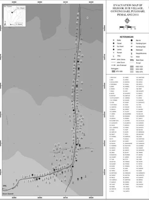
5.3 Silegok Sub Village
Silegok Sub Village is located at the east of Gunungsari Village bordered by Sipendil and Krajan Sub Village as its west side, Karangsari Village at north and Penakir Village at east. The distance between Silegok Sub Village and the central crater of Slamet Volcano is approximately 7 km. Walim River is a marker of the border between Sipendil and Krajan Sub Village. There are 150 householders living at Silegok Sub Village including 358 men and 339 women that are divided into 4 RT. Vulnerable population comprises with 31 children, 5 elderly, 4 pregnant women and 1inhabitant with disability.
The TPS is located in Gunungsari Village meeting hall. It belongs to Sipendil Sub Village. The longest distance from the resident house is about 2 km. The evacuation map is shown in Figure 4. There is only 1 four wheel vehicle for transportation. As in Sipendil Sub Village, it also uses kentongan and mosques loudspeaker to give warning.
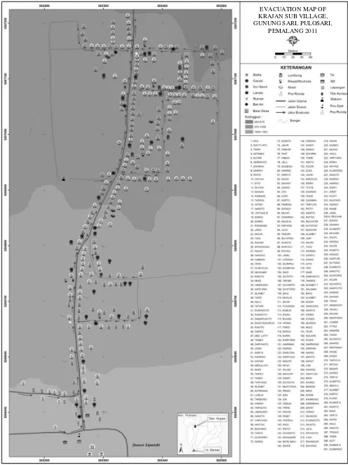
5.4 Krajan Sub Village
Since Krajan Sub Village is located at the lower area, there is no TPS built here but there are two assembly points provided if the evacuation is needed (see Figure 5). Independent transportation facilities used here are 12 four wheel vehicles. Kentongan and mosques loudspeaker can be functioned as the warning sign.
5.5 Scenario of Evacuation at Sipendil Sub Village
The location of temporary shelter is at Elementary School 01 Gunungsari which has open space with 60 meters in length and 30 meters in width, the total area is 1800 m2. It can accommodate 1.079 resident house
of Sipendil Sub Village. The availability of independent transportation facilities is assumed to be
able to standby at each location or each RT. From some scenarios, the estimation of overall time required to evacuate all of the residents to the TPS is 1 hour 37 minutes 22.8 seconds (the quickest) and 3 hours 6 minutes 7 seconds (the longest).
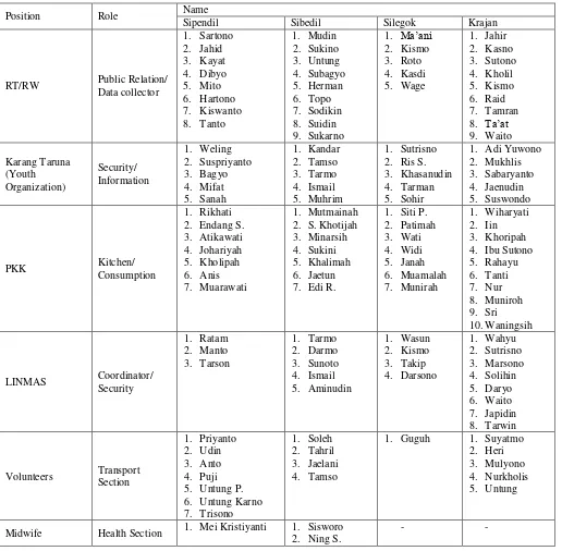
5.6 Disaster Preparedness Team
Disaster preparedness team at each Sub Village as seen in Table 5 was formed to follow up the preparation of evacuation maps that have been done, and is expected as an activator related to the activities in each village.
Table 5. Disaster preparedness team among four sub villages in Gunungsari Village.
Position Role Name
Sipendil Sibedil Silegok Krajan
RT/RW Public Relation/ Data collector 2. Suspriyanto 3. Bagyo
LINMAS Coordinator/ Security
Figure 2. Evacuation map of Sipendil Sub Village.
EVACUATION MAP OF SIPENDIL SUB VILLAGE, GUNUNG SARI,
EVACUATION MAP OF SIBEDIL SUB VILLAGE, GUNUNG SARI,
Figure 4. Evacuation map of Silegok Sub Village.
EVACUATION MAP OF SILEGOK SUB VILLAGE, GUNUNG SARI, PULOSARI,
Figure 5. Evacuation map of Krajan Sub Village
EVACUATION MAP OF KRAJAN SUB VILLAGE, GUNUNG SARI, PULOSARI,
6 CONCLUSIONS
Some conclusions that can be inferred from mapping the evacuation route against Slamet Volcano eruption disaster in Gunungsari Village, Pulosari Sub District, Pemalang District are as follows
a) In general, people living at those four sub villages in Gunungsari village has been aware about their existence in Slamet volcano disaster-prone areas so that they consider using evacuation map as guidance. The preliminary questionnaire showed a high public enthusiasm about whether evacuation map is needed. Percentages of disaster preparedness are 97% for Dusun Sipendil, 83% for Dusun Sibedil, 67% for Dusun Silegok and 63% for Dusun Krajan.
b) A good understanding level of the drafted evacuation map for evacuation site, people evacuation time, and restricted area eruption. The evaluation questionnaires resulted, mainly for evacuation time and location, 100 % at Sipendil Sub Village, 97% at Sibedil Sub Village, 80 % at Silegok Sub Village, and 80 % at Krajan Sub Village.
c) Understanding level towards Slamet Volcano current status is quite low, namely 36,67 % for Sipendil Sub Village, 20 % for Sibedil Sub Village, 63,33 % for Silegok Sub Village, and 36,67% Krajan Sub Village.
7 SUGGESTIONS
Some recommendations can be given for succeeding research are as follows:
a) Evacuation map may not be the ideal since coordination with surrounding villages has not been accounted yet, especially for Silegok Sub Village.
b) Evacuation maps and disaster preparedness team intended as the main aim should be more organized and have the legality of their presence. Hence regulations / decision on village level or on the higher level should be considered.
c) In order to optimize the implementation of the survey, participants should be specified in advance before. The survey results can be more representative as well as actual condition in the community.
d) There are seven villages in Pulosari District included into disaster-prone areas. Those villages should be prepared as well so that each village has an evacuation guideline. Local government is expected to be able to conduct periodically dissemination or evacuation training either for
people or disaster preparedness team, so that the people can directly feel the condition that may occur during disaster attack
e) A tight cooperation with the observatory post at Gambuhan Volcano as the extension of the Centre of Volcanology and Geological Hazard Mitigation (CVGHM) in Bandung having the most understanding agency regarding to volcanic activity of Slamet Volcano is considered important. The location of observatory post is not too far from the Gunungsari Village, so that it apparently becomes easier to find out the latest information about Slamet Volcano activity.
REFERENCES
Anonymous. (2009). “Hasil Pemantauan Aktivitas Gunungapi Slamet Pada Level Waspada s/d Siaga Tanggal 21 April s/d 2 Mei 2009” [Observation Activity Result against Slamet Volcano from Caution to Warning ELvel during 21st April until 2nd May 2009]. A Report. Agency
of Energy and Mineral Resources, Banyumas.
Alzwar, M., et al. (1987). Pengantar Dasar Ilmu Gunungapi [Introduction to Basic Knowledge of Volcanology], Nova, Bandung.