LAND CAPABILITY EVALUATION FOR AGRICULTURE IN KRUENG SIEUMPO WATERSHED, ACEH
1Halus Satriawan,2Erwin Masrul Harahap,3Rahmawaty,4Abubakar Karim 1University of Almuslim, Aceh, Indonesia
2,3University of North Sumatera, Medan, Indonesia 4Syiah Kuala University, Banda Aceh, Indonesia
Abstract
Land utilization especially land in watershed should be based on land capability. Land capability should be classified based on their potential for general agricultural utilization without causing damage in the long term. Land utilization in Krueng Sieumpo watershed should be based on its land capability. This research was conducted in Krueng Sieumpo watershed Aceh Indonesia that located on 96o40'00"- 96o50'10" E and 04o52'20 "- 05o07'40" N in June-December 2013. Land capability class in this location were grade II (3.35%), III (33.26%), IV (25.07%), VI (30.78%) and VII (7.53%), with dominant limiting factors were slope (l),erosion hazard (e), rocks (b), and permeability (p).
Key words:Land capability, Limiting factors, Agriculture
Introduction
Soil and water are the most important resources in the watershed which is intended for human activity (Badaruddin, et.al, 2013). One form of land use by humans is in agriculture, wherein Land use for agriculture can be optimally by adjusting land use to land capability (Oluwatosin, et al., 2006). Land use must be in accordance with the terms of the required, so that the soil can function properly without reducing fertility (Lin, et.al, 2012).
The increase in the number of people accompanied by the increase in the economic needs, especially for the benefit of agriculture, makes a pressure rate on land resources inevitable that causes an impact on the land degradation and the environmental pollution (Lu et al., 2008). To be able to utilize the land resources in a focused and efficient, are require appropriate technology to optimize land (Shekinah, et.al, 2004), complete information on climatic conditions, biophisyical soil properties, as well as the growing requirements of the plants to be cultivated, especially the plants that have economic value (Saida, et.al, 2013).
form , length and slope and processes at work in the land ( Hardjowigeno and Widiatmaka , 2007).
Krueng Sieumpo watershed located in three districts, most of its territory located in Bireuen District has high potential of land especially for agriculture. Potential of existing land when there is no special attention will forever be a potential output, that is, not important and benefecial product. But now that potential has not been optimally arranged, therefore there is no outstanding contribution. Therefore, for the expectation to be realized, it requires an effort in order to know for certain about the potential of Krueng Sieumpo watershed by determine the ability of land as well as how land suitability can be modified so as to produce the maximum production.
Krueng Sieumpo watershed landscape largely hills and mountains shaped with slopes sufficient conditions varied. Seeing the potential of that land is good enough for a variety of pupose, eg for settlements, agricultural, livestock, irrigation, should be based on an evaluation of land capability and land suitability. so that land use in the region can be classified according to their proper use. Therefore, evaluation of the ability in Krueng Sieumpo watershed needs to be done, so that Krueng Sieumpo watershed land use can be adapted to land capability. Thus, land degradation can be minimized and land use is sustained.This study aimed to evaluate land capability in Krueng Sieumpo watershed that use as agricultural cultivation land.
Research Methods
Sources and Data Collection Techniques
Observations and data retrieval of soil properties for land capability evaluation performed on each of land units. Land units formed from overlay between soil type maps, slope maps and land use maps (Alesheikh, et.al, 2008). Soil properties and land use in land capabilities evaluation include physical properties and morphology of the land and that can be directly observed in the field and soil analysis results in the laboratory.
Land capability classes based on its potential for general agriculture without causing any damage in the long term (Arsyad, 2010). Physical and morphological properties were observed for the grade level is slope, erosion sensitivity, soil solum, soil texture, permeability, drainage, presence of rocks on the surface, the threat of flooding and salinity or sodium content. For the division of the sub-class, it is observed: the threat of erosion (e), or excess drainage water conditions or the threat of flooding (w), root zones barriers (s), and climatic barriers (c) (Arsyad, 2010).
Data analysis
Land capability classification used is the system of the United States Department of Agriculture (USDA), which is expressed in Agricultural Handbook No. 210 (Klingebiel and Montgomery, 1961 in Arsyad, 2010). The classification of land capability made up to subclass category. Grouping in to class based on the intensity of the inhibiting factors. Land grouped in eight classes, namely class I to VIII. The threat of damage or resistance increased successively from class I to VIII. Land on class I to IV with good management and is able to generate suitable for a variety of uses. Land on the class V, VI, and VII according to pasture, plant trees or natural vegetation. Class of VIII land should be left in its natural state (Hardjowigeno and Widiatmaka, 2007).
changed or partially mitigated and are limitations on the precedence of the climate in determining the subclass, and subclass marks given e, w or s. Lands with no limiting except climate characterized by subclass c. Land capability classification matrix criteria presented in Table 1.
Table 1. Matrix Criteria of land capability class
No Limiting Factors land capability class
I II III IV V VI VII VIII
1 Surface slopes (l) 0 1 2 3 0 4 5 6
2 Erosion level (e) 0 1 2 3 (**) 4 5 (*)
3 Soil solum (k) 0 0 1 2 (*) 3 (*) (*)
4 Texture of the top layer (t)
1-3 1-3 1-4 1-4 (*) 1-4 1-4 5
5 Texture of the bottom layer (t)
1-3 1-3 1-4 1-4 (*) 1-4 1-4 5
6 Permeability (p) 2-3 2-3 2-3 2-3 1 (*) (*) 5
7 Drainage (d) 1 2 3 4 5 (**) (**) 0
8 Rocks (b) 0 0 1 2 3 (*) (*) 4
9 Flooding hazards (o) 0 1 2 3 4 (**) (**) (*)
10 Salinity (***) 0 1 2 3 (**) 4 (*) (*)
Source: Arsyad (2010); Description: (*): Can have any properties; (**): Not applicable; (***): Commonly found in dry climates
Results and Discussion
Land units in Krueng Sieumpo Watershed
Land unit is a unit of lands that has similar characteristics . In this study, land unit was formed based on common land slope, soil type , and land use . Results overlay map soil type, slope maps and map use in Krueng Sieumpo watershed acquired 24 land units. There are 11 units of land in Krueng Sieumpo watershed used for agricultural cultivation, which consists of : the moor (4 land units), non irrigated rice (1 land unit) and mixed farms (12 land units). Whereas two other land units used in non-agricultural land use such as forests and grasslands. Soil types in Krueng Sieumpo watershed consists of Alfisol, Entisol, Inceptisol and Ultisol. Slope is declivous to steep.
Physical Characteristics of Land in Krueng Sieumpo Watershed
The physical characteristics of the land in Krueng Sieumpo Watershed include slope, erosion sensitivity, soil solum, soil texture, permeability, drainage, presence of rocks on the surface, and exposed rocks. The results of the field observations and laboratory analysis are presented in Table 2.
No Land
e None None None Good
2 1
e None None None Good
3 17
e None Slight None Good
4 20 Steep Few
e None Slight None Good
9 4
e None None None Good
10 9
e None Slight None Good
11 15 Slopin
No Land
e None Slight None Good
14 5
g Fast Depth Fine
Non e
tidak
ada Slight None Good
16 22 Steep Few
fast Depth
Slope on Krueng Sieumpo watershed are between gentle, sloping, moderately sloping, hilly, Strongly sloping, and steep. The slope of the land affects the erosion that occurs. The more oblique the slope, the greater erosion is ( Satriawan and Harahap , 2013) . This can be seen in the parameters of erosion rate. Erosion in Krueng Sieumpo watershed range from none, slight dan medium.
Effective soil depth is the depth of good soil for the growth of plant roots, that is until the layers cannot be penetrated by plant roots. Effective soil depth found in Krueng Sieumpo watershed is from medium ( 80-90 cm) to depth ( > 90-175 cm). Soil depth greatly affects the development of plant roots . The development of plant roots determine the productivity of crops.
Soil texture is the relative comparison between the fraction of sand, silt and clay. Soil texture in Krueng Sieumpo watershed quite varied; medium, few fine and fine. Medium -textured soils include clay. Rather fine texture soils are clay loam, and fine texture is sandy clay.
The permeability of the soil in Krueng Sieumpo watershed includes the range from medium, few slow, few fast and fast. The rates are: few slow category, the permeability is 0.5 to 2.0 cm/hr, medium category is 2.0 to 6.25 cm /hr, few fast category is 6.25 to 12.5 cm/hr, and fast categories with > 12.5 cm /hr. Soil drainage of land in Krueng Sieumpo watershed classified as good . Good drainage means that the soil has good air circulation. The whole land from top to bottom brightly colored uniform and there are no patches of yellow, brown or gray .
The rock on the surface is rough or small rock materials diameter 7.5 cm to 25 cm if a round, or long axis measuring 15 cm to 40 cm if shaped depressed (Wright , et.al, 2006) . The abundance of small rocks on the surface of the soil in the study area is none to slightly, and has no effect on the treatment of soil and crop growth. The rocks outcrop is a small portion of the rock that appears on the surface and most are found in the soil (Bibby , et.al, 1991). There is no outcrop in Krueng Sieumpo watershed , meaning that less than 2% of the land surface covered by rocks that appear on the surface of the ground.
Land Capability Classification in Krueng Sieumpo watershed
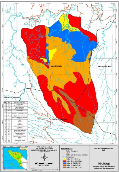
Based on the physical and morphology characteristics of the land presented in Table 2, and the matrix of the criteria from the USDA land capability classification modified (Arsyad, 2010) in table 1, the land in Krueng Sieumpo watershed are included in the category of classes II, III, IV, VI, and VII, with the limiting factor permeability (p), the slope (l), the threat of the occurrence of erosion (e) and the rock surface (b). Land capability classification for each land unit are presented in Table 3 and Figure 1.
Land capability class II in Krueng Sieumpo watershed is a gently slope (3-8 %), permeability is (2.0 to 6.25 cm /hr) , and the depth is - in ( 80-115 cm). Land capability class II suitable for a wide range of uses, including use for seasonal crops, annual crops, pasture, forest production, etc. Therefore, when applied to agricultural crops each season, in order the land is not damage, it requires a light soil conservation actions such as the addition of organic matter to improve water binding capacity , mulch and mound ducts. Land area for class II in Krueng Sieumpo watershed is 1048.9 ha (3.35 %).
Class Subclass Area (ha)
percentage (%)
II IIp 1048.9 3.35
III
III l 6597 21.08
III l,e 3758.2 12.01
III l,e,b 53.9 0.17
IV
IV l 1928.2 6.16
IV l,e 5915.9 18.91
VI VI l,e 9631.7 30.78
VII VII l 2356.5 7.53
Total 31.290,3 100
Land capability Class III is located on land that slopes with a slope slightly sloping or undulating (8-15 %), soil depth is (85-125 cm). These are sensitive to erosion or erosion experienced mild - moderate, and surface rocks lightly. Land capability class III is suitable for crop farming season, annual crops, pasture, forest production, or protected forests. If used for agriculture, so as not damage and loss of hydrological function, then require pretty heavy conservation action by manufacturing mound ducts, addition of organic matter, no tillage, minimum tillage or a combination of vegetative method. The data in Table 3 shows the total area of land class III in Krueng Sieumpo watershed is 10.409,1 ha (33.27 %). Class III with slopes limiting factor ( l ) ( subclass III l ) is 6597 ha, land with slopes and erosion limiting factors (subclass III l , e ) are 3758.2 ha, and land with a limiting factor slopes, erosion and rock (subclass III l , e , b) measured as 53.9 ha.
Land capability class IV is located on the slopes gently sloping or hilly (15-30 %), and medium depth soil ( 80-90 cm), has experienced erosion are (50% of the top layer has been lost). Land capability class IV can used for seasonal crops, annual crops with good ground cover, pasture, forest production, or protected forests . If applied to the crop season, to avoid damage and loss of soil function, so that conservation action is required as heavy as the core manufacturing benches, individuals benches, rorak , and a combination of several methods such as vegetative ground for cover crop. Land area for class IV in Krueng Sieumpo watershed is 7844.1 ha (25.07 %), the limiting factor is the slope and erosion (subclass IV l, e).
in Krueng Sieumpo watershed is 2356.5 ( 7.53% ) ha, the limiting factor is the slope ( subclass VII l ) .
Table 4 . Suitability classification of land use in each land capability class and land use direction in each land unit
Land Unit class Limiting
factor area (ha) Actual land use Suitable/not
direction of land use / management
3, 4, 11 II p 1005 rainfed rice fields, coconut
gardens, moor, forest suitable
Addition of organic matter to improve
water binding capacity, mound ducts
1, 2, 5, 8, 9, 10,
12, 14, 17, 18 III l, e, b 10409.1 moor, mixed farms, forests suitable
Muound ducts, addition of organic materials, no-tillage or
a combination of the methods of vegetative
6, 13, 15, 16, 21 IV l, e 7844.1 garden, moor, rainfed suitable terracing/mound/rorak, cover crops
20, 22 VI l, e 9631.7 Garden, moor Not suitable agroforestry
23, 24 VI l 2356.5 forest, shrub suitable Maintaining the
current land use
Conclusion
Land capability classes in Krueng Sieumpo watershed consists of five classes . Land capability class II has a permeability limiting factor (subclass PII ). Land capability class III has a slope limiting factor (subclass III l ), slope and erosion limiting factor ( subclass III l , e ), and slopes, erosion hazard and rocks limiting factors (subclass III l , e , b ). Land capability class IV has a slope limiting factor ( subclass IV l ), slope and erosion hazard ( subclass IV l , e ). Land capability class VI has a limiting factor slope and erosion hazard (subclass VI l,e ). Land capability class VII has a slope limiting factor (subclass VII l ) .
References
Alesheikh, A. A., Soltani, M.j., Nouri, N., and Khalilzadeh, M., 2008. Land assessment for flood spreading site selection using geospatial information system. Journal of environmental science and technology 5(4), 455-462.
Arsyad, S. 2010. Konservasi Tanah dan Air. IPB Press. Bogor.
Badaruddin, M. Ruslan, Z. Kusuma, M.L. Rayes, 2013. An analysis of land characteristics and capabilities in Kusambi sub-watershed of batulicin watershed in tanah bumbu regency south Kalimantan. Academic Research International. Vo. 4 No.5 September 2013. Pp. 222-233
Bibby, J.S., 1991. Land Capability Classification for Agriculture. The Macaulay Land Use Research Institute, Aberdeen.
Hardjowigeno, S. dan Widiatmaka. 2007. Evaluasi Kesesuaian Lahan dan Perencanaan Tataguna Lahan. Gadjah Mada University Press. Yogyakarta.
Kusumaseta, 1987. Konservasi Tanah dan Air. UI Press. Jakarta.
watershed. International journal of environmental research and public health, 9(12), 4083-4102. Doi:10.3390/ijerph9114083.
Lü, Y., Chen, L. & Fu, B. (2008). Land-cover effects on red soil rehabilitation in China: a
meta-analysis. Progress in Physical Geography, 32(5), 491–502.
doi:10.1177/0309133308098942
Oluwatosin, G.A., O.D. Adeyolanu, A.O. Ogunkunle, and O.J. Idowu. 2006. From Land Capability Classification to Soil Quality: An Assessment. Tropical and Subtropical Agroecosystems (6): 49-55.
Saida, Abdullah, K. Jusoff, M. Ilsan, A. Haris and Nuraeni, 2013. Evaluation of land capability for agriculture in the upstream of jeneberang watershed, South Sulawesi. American-Eurasian J. Agric. & Environ. Sci., 13(8): 1027-1033. DOI: 10.5289/idosi.aejaes.
Samranpong, C., B. Ekasingh dan M. Ekasingh, 2009. Economic land evaluation for agricultural resource management in northern Thailand. Environmental modeling & software. 24: 1381-1390.
Satriawan, H., dan E.M. Harahap, 2013. Kajian erosi tanah pada sub DAS Krueng Sieumpo Aceh. Prosiding Seminar Nasional Pengelolaan DAS Berbasis Masyarakat Menuju Hutan Aceh Berkelanjutan, Banda Aceh. ISBN: 978-979-8278-89-1. p171.
Shekinah, D. E, S. K. Saha, and R. Rahman. 2004. Land Capability Evaluation for Land Use Planning Using GIS. J. Of the Indian Society of Soil Science, Vol. 52 : 3 pp. 232 – 237. Wright I.A., R.V. Birnie, A. Malcolm, W. Towers and M. McKeen. 2006. The Potential Use
Fw: submitt article
Inbox x
halus satriawan
Nov 30, 2018, 5:06PM (2 days ago) to Rahmawaty, me
Pesan yang Diteruskan
---Dari:The Editor, Academic Research International <[email protected]> Kepada:"[email protected]" <[email protected]>
Terkirim:Sabtu, 26 April 2014 23.03.03 GMT+7 Judul:Re: submitt article
On Sat, Apr 26, 2014 at 9:02 PM, The Editor, Academic Research International <[email protected]> wrote:
Dear Author,
Thank you for submitting paper(s) to "Academic Research International (ARInt.)" for May 2014 / July 2014 issue. We will inform you after completing peer review process within 3-4 weeks:
Ref-ID: 0503-1591-ARInt-42014
Title: LAND CAPABILITY EVALUATION FOR AGRICULTURE IN KRUENG SIEUMPO WATERSHED, ACEH
Author(s): Halus Satriawan, Erwin Masrul Harahap, Rahmawaty, Abubakar Karim
Words:3610
Publication Fee: USD70
Quick Review Fee: USD30[To complete review process in 7-10 days for May 2014 issue, if interested please inform]
Subscription for print @USD 30per copy (Optional)
Country: INDONESIA
Note: Article publication fee is 70USD (or 7000PKR) for paper not more than 4000 words. 0.02USD will be charged for each additional word. If the paper is accepted for publication, you will be asked to pay article publication fee. For detailshttp://www.journals.savap.org.pk/authors.html].
With best wishes,
The Editorial Team,
Academic Research International (AR Int.)
ISSN-L: 2223-9553
http://www.journals.savap.org.pk
On Sat, Apr 26, 2014 at 8:25 AM, halus satriawan <[email protected]> wrote:
To the honorable Editor of Academic Research International (AR Int.)
Dear Sirs,
Introduce me, Halus Satriawan, a lecturer at the University of Almuslim, Bireuen, Aceh, Indonesia. I intend to submit myl article for publication in an upcoming issue of this journal. I hereby attach the article.
Fw: Confirmation Mail Re: submit article
Inbox x
halus satriawan
Fri, Nov 30, 5:05 PM(2 days ago) to Rahmawaty, me
Pesan yang Diteruskan
---Dari:The Editor, Academic Research International <[email protected]> Kepada:"[email protected]" <[email protected]>
Terkirim:Sabtu, 24 Januari 2015 21.26.08 GMT+7 Judul:Confirmation Mail Re: submit article
Thank you for your mail.
We will inform you after completing the process. Please visit
http://www.journals.savap.org.pk
for updates.
Smiles with regards The Editor
Academic Research International(AR Int.) ISSN-L: 2223-9553 online
http://www.journals.savap.org.pk
Email:[email protected]