Analysis of Soil Erosion in Agricultural Land Use in Krueng Sieumpo
Watershed Aceh Province
Halus Satriawan1, Erwin Masrul Harahap2, Rahmawaty3, Abubakar Karim4 1
Doctoral Student in Agricultural Science, North Sumatera University, Medan, 2,3
Agricultural Science Postgraduate Program, North Sumatera University, 4
Syiahkuala University, Banda Aceh, INDONESIA.
ABSTRACT
Greater soil erosion is compared with the erosion of tolerance is one of the forms of land degradation are common throughout the world, both within the small region to large areas such as the scope of the Watershed and cause a decline in land productivity, water quality and disruption hydrological system until causing the failure of the environmental sustainability. The research has done with the aim of identifying, analyzing and mapping the erosion that occurs as a result of different land uses in Krueng Sieumpo watershed in Aceh Province. Determination of erosion value is done by using a predictive evaluation of erosion with RUSLE, and erosion hazard index was calculated by compared soil erosion value with the tolerable erosion. The results showed that the erosion rate of 1.9 – 1.343,4 ton/ha/year, and tolerable erosion value was13.70 – 21.26 ton/ha/year. The rate of erosion is divided into categories of mild, moderate, high and very high with the major factors affect is the amount of erosion that occurs is the slope, slope length, crop management / land use, soil management and soil erodibility.
Keywords: Revised Universal Soil Loss Equation, Erosion tolerance, Level of erosion hazard
INTRODUCTION
Greater soil erosion that compared with the tolerable erosion is a common degradation form which occurs throughout the world, both within the small region to large areas such as the noticed linkage constituent elements of watershed systems. Whereas. The principle of using has caused damage to watersheds in Indonesia.
Krueng Sieumpo watershed is one of the sub-watershed of the Krueng Peusangan watershed located in Aceh Province, and its currently zoned first priority to be managed and rehabilitation (surat keputusan menteri kehutanan dan perkebunan No.: 284/1999). Sieumpo Krueng sub watershed has an area of 29541.9 ha with the upstream region of the central highlands and the downstream located in Bireuen District.
tillage and cultivation on steep slope have also increased the risk on soil erosion by water [2]. In Krueng Sieumpo watershed, the land capability class are categorized of class II - VIII, In some places, land VI, VII and VIII still used as intensive agricultural without in accordance with land capability and suitability; also none implementing conservation techniques, both in terms of cropping patterns and farming practices [3]. Oil palm (Elaeis guineensis), Areca (Areca catechu L.) and Cocoa (Theobrema cacao L.) are major crops in Kreueng Sieumpo watershed, which spread more dominant on land with slopes between 9-45% [4]. The land area for oil palm plantations in Krueng Sieumpo watershed have increased rapidly, with 4.644 ha of cultivation under 5 years since 2008 [5]. But today, agricultural cultivation is limited to marginal areas such as hilly sloping lands where they comprise about 60% of the marginal land areas [6](Satriawan and Fuady, 2012).This is due to the consideration of land use only stressed on the economic considerations. The land use pattern like this is very likely to lead to land degradation such as erosion and flooding. At least this condition has lasted over a period of 5-10 years.
Determination of the erosion rate is very important for the sustainability of agricultural activities. If the erosion value has crossed the tolerable erosion, there should be efforts to reduce erosion so that the continuity of farming system can be reached. One of its by predicting erosion that occurs in this region. However, at present the most commonly used methods of predicting the average water erosion rate from agricultural lands are the Universal Soil Loss Equation (USLE) [7] and the Revised Universal Soil Loss Equation (RUSLE) [8]. RUSLE is basically used to predict average annual soil losses due to sheet and rill erosion. Although sheet and rill processes are two different forms of erosion, they are usually considered together in the assessment procedure for soil losses.
This study aims to analyze the erosion that occurs as a result of a variety of agricultural land use in Krueng Sieumpo watershed Aceh province.
MATERIAL AND METHODS
Study Area in Krueng Sieumpo Watershed
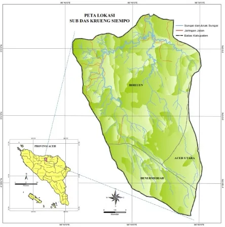
The Krueng Sieumpo watershed, covering 31.290 ha and was located in five sub-districts, respectively Juli, Peusangan Selatan, Peusangan Siblah Krueng, Makmur (on Bireuen Regency), and Pinte Rime Gayo (Bener Meriah Regency) (Longitude 96o52'00" to 97o31'00" East and Latitude 04o46'00" to 05o00'40" North) (Figure 1).
Krueng Sieumpo watershed consist of various land uses such as primary forest, tree crop garden covered oil palm (Elaeis guineensis), cocoa (Theobrema cacao L.), areca (Areca catechu L.), grassland, rice field, and mixed garden. Mixed garden refers to land where parennial crops, mostly trees such as coconut, teak, mahagony are planted with a combination with annual crops [9]. Chili (Capsicum annum L), soybean (Glycine max L), corn (Zea mays
L), papaya (Carica papaya L.) were major crops in vegetable garden.
Figure 1 Study site in Krueng Sieumpo Watershed, Aceh, Indonesia
Erosion Analyses
Analysis of the data to predict the soil of erosion are determined based on the Revised Universal Soil Loss Equation (RUSLE). Erosion prediction performed on each unit of land at the study site. The equation used for prediction of erosion is as follows [8]:
A = R * K * L * S * C * P (1)
Rainfall Erosivity Factor (R-factor)
R-factor is rainfall erosivity factor which the potential ability of the rain to cause soil erosion. For computing the monthly or parennial value, the calculation erosivity rain in RUSLE model using the procedure proposed by [8] through the following equation:
0Where Ej is erosivitas monthly rainfall (MJ mm / ha / h / year); Rd is the daily rainfall; R0 is
the daily rainfall causing erosion (R0 ≥ 12.7 mm); N is the number of rainy days is the
amount of rain in accordance with R0; f = 1/12 is the frequency; = 5 / 6; , , and are the model parameters, the relationship between and described as equation (3), where the annual rainfall> 1,050 mm. The relationship between annual rainfall and P shown in soil organic matter content, bis the soil structure code, c is permeability class code of the soil. If the organic matter content> 4%, organic matter is assumed to be a constant value of 4%.
In general, R-factor and K-factor are the most important factors that need evaluation based on local conditions for successful aplication the model [12].
Slope length and steepness factor (LS-factor)
Each grid was considered as a single plane. The length and slope are determined based on data obtained from measurements in the field using a clinometer or Abney hand level or a tool like. Furthermore, these two factors were calculated using equation [13] or Renard [8]:
2
Cover crop (C-factor) and conservation practices (P-factor) factors
Tolerable erosion is calculated based on the concept of equivalent depth of soil [14] with the equation: (DE - Dmin) / MPT + PT. While Erosion Hazard Index (EHI) is setted according to [8].
RESULTS AND DISCUSSION
Prediction and Evaluation of Erosion
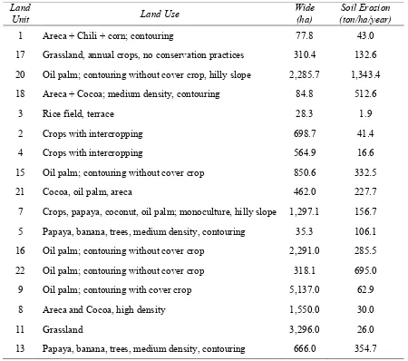
In this study, the tolerableerosion on agricultural land in the study area are 13.70 – 21.26 ton/ha/year. In general, the study area has erosion predictive value ranging from 1.9 – 1.343,4 ton/ha/year(Figure2). Land units that have erosion predictive value smaller than tolerable erosion are3LU(3, 4 and 14) with erosion range of 1.9 – 16.6 ton/ha/year. While 14 others (1, 2, 5, 7, 8, 9, 11, 13, 15, 16, 17, 18, 20, 21 and 22c) have the greater predictive erosion value than tolerable erosionare26 – 1.343,4 ton/ha/year. The total area that has a value is less than the predicted erosion tolerable erosion reach 3.829,4 ha (12.96 %), while in excess of tolerable erosion, reach 19.360,45 ha (63.53 % ) of the watershed total area.
Table 1. Soil erosion value in agricultural land use in Krueng Sieumpo watershed
Land
Unit Land Use
Wide (ha)
Soil Erosion (ton/ha/year)
1 Areca + Chili + corn; contouring 77.8 43.0
17 Grassland, annual crops, no conservation practices 310.4 132.6
20 Oil palm; contouring without cover crop, hilly slope 2,285.7 1,343.4
18 Areca + Cocoa; medium density, contouring 84.8 512.6
3 Rice field, terrace 28.3 1.9
2 Crops with intercropping 698.7 41.4
4 Crops with intercropping 564.9 16.6
15 Oil palm; contouring without cover crop 850.6 332.5
21 Cocoa, oil palm, areca 462.0 227.7
7 Crops, papaya, coconut, oil palm; monoculture, hilly slope 1,297.1 156.7
5 Papaya, banana, trees, medium density, contouring 35.3 106.1
16 Oil palm; contouring without cover crop 2,291.0 285.5
22 Oil palm; contouring without cover crop 318.1 695.0
9 Oil palm; contouring with cover crop 5,137.0 62.9
8 Areca and Cocoa, high density 1,550.0 30.0
11 Grassland 3,296.0 26.0
13 Papaya, banana, trees, medium density, contouring 666.0 354.7
units that have greater erosion prediction than tolerable erosion is a unit of land with slopes somewhat skewed class - steep (15-60%).
Factors of land use (crop and its management) and soil conservation measures are applied also affect the potential for erosion. On land units 13, 20 and 22c in the form of land use without ground cover, young age oil palm without ground cover and open grassland. It required the application of appropriate soil conservation techniques to minimize erosion prediction value is going to happen.
Soil erodibility (K) is the sensitivity of the soil to destroy the power and washout by rain water. Soil with a high erodibitas is increasingly vulnerable to erosion. At the study site there are four (4) types of soil, namely Alfisol (LU 1, 2, 8, 9, 10, 17, 18, and 19), Entisol ( LU 3 and 4), Inceptisol (LU 11, 12, 20 , 21 and 22) and Ultisol (SL 5, 6, 7, 13, 14, 15, 16, 23 and 24). The value of soil erodibility for each soil type different from each other. Alfisol soil erodibility ranged from 0.272 to 0.595 with an average of 0.372, 0.384 Entisol, Inceptisol ranged from 0.252 to 0.655 with an average of 0.360, and Ultisol ranged from 0.235 to 0.647 with an average of 0.404. Based on the classification of soil K value in Alfisol, and Ultisol Inceptisol have a higher sensitivity to erosion is-very high, while the ground Entisol rather high level of sensitivity[15], [16] and [17].
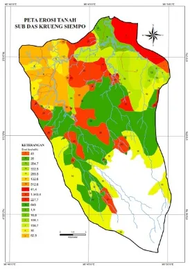
Evaluation Erosion Based on Erosion Hazard Potential
Evaluation of erosion potential is an assessment of the potential dangers of harmful erosion or a threat to the degradation land of an area based on erosion prediction results are compared with the value of the tolerable erosion. The results of the erosion potential evaluation are presented in Table 2. Based on Table 1 below shows that the calculation results obtained erosion hazard index values the dignity of the low - very high (0.03 to 63.24). 11 unit of land with an area of 12760.45 ha (40.88%) is at a low erosion rate, 6 units of land with an area of 12 166 ha (41.18%) are at the level of erosion hazard is, 2 units of land with an area of 777.40 ha (2.61%) are at a high erosion hazard, and 5 units of land with an area of 4527.05 ha (15.32%) are at a very high erosion hazard.
Table 2. Level of erosion hazard in Krueng Sieumpo Watershed
No Erosion Hazard Land Unit Erosion Hazard Value
Value of erosion potential by category medium, high and very high at the study site is a unit of land that has predictive value erosion greater than tolerable erosion. This means that the
amount of erosion that occurs can’t be matched by the rate of soil formation. Therefore, in the land units necessary soil and water conservation measures.
Direction of Application of Soil and Water Conservation
Lands with high erosion potential degradation has great potential if the land use is not accompanied by the application of soil and water conservation right. Prevention and control of erosion can be done through the application of mechanical engineering, vegetative, chemical or a combination of all three. Application of soil and water conservation technologies must be adapted to the biophysical conditions and the type of crops grown. Land unit with erosion hazard index medium is the rate of erosion ranged from 26 to 64.1 ton/ ha / year with land use monoculture and mixed shrubs, gardens and moor. Other biophysical characteristics is the slope of 8-15%, slope length 15-40 m and soil erodibility are - high. Soil and water conservation technologies are feasible on this land units group is a technology that can increase soil permeability and shorten the length of the slope. Ridges, cover crops plants and the addition of organic material from the crop residues potentially increase water absorption and reduce runoff so that the rate of erosion can be reduced.
plants terrace is a technology that can be recommended. Bench terraces can be applied to land with a slope of 10-40% [18], but must pay attention to the depth of the soil and the levels of Fe and Al. At the study site, the effective depth is still possible made patio benches, as well as the levels of Fe and Al is not a factor inhibitors, because the order of land in land units 17 and 21 is Alfisol.
Groups of land units with very high levels of erosion hazard index requires handling very carefully because of the severe biophysical characteristics. The rate of erosion ranged from 428.8 to 1517.7 tonnes/ha/year with bare land land use, monoculture plantations without any application of soil conservation. Other biophysical characteristics is the slope of 35-60%, slope length 28-38 m and soil erodibility are - high. Conservation technologies used in these land units requires good planning. In the land unit 20, 22 c, 15 and 16 with a slope of 60%, and young age oil palm should be applied to the specific soil conservation techniques such as bench terrace, sediment trap and cover crops of legumes group. Similarly, land unit 18 with a slope of 40% and plantation crops such as areca and cocoa, should be applied multistory cropping system. Bench terracing still can be done by planting crops of strengthening terrace.
Ridges of soil pile is made elongated contour ridges and upper slopes adjacent to the channel prepared to follow the direction of the ridges. The existence of such channels can increase the absorption and inhibition of surface runoff. This condition will give you the opportunity runoff to soak into the soil around the channel for longer, so that the excess water is lost from the mapped surface is reduced [19]. Ridges are effectively used on land with a slope of 10% - 40%, can also be applied to the slope of 40-60% but less effective [18]. In this regard, [20] obtain the efficiency of runoff and erosion control with application-canal ridges terrace of 49.6% on land with a slope of 15%.
CONCLUSION
Based on the data and discussion presented in the previous chapter, it is concluded as follows:
1. Soil erosion value in Krueng Sieumpo watershed is ranging from 1.9 – 1.343,4 ton/ha/year;
2. The tolerable soil erosion in Krueng Sieumpo watershed is ranging from 13.70 – 21.26 ton/ha/year
3. Soil erosion value is smaller than tolerable erosion of 1.9 – 16.6 ton/ha/year. While the soil erosion value is greater than tolerable soil erosion are 26.0 to 1571.7 ton/ha/yearr;
4. The main factors that affect the amount of erosion occurs is the slope factor, crop management / land use, soil management and soil erodibility;
5. The rate of erosion is at the level of mild, medium, high and very high so it requires the application of soil and water conservation technologies to maintain the sustainability of land resources;
REFERENCES
[1]. Kartodihardjo, H, K., Murtilaksono dan U., & Sudadi. (2004). Institusi pengelolaan daerah aliran sungai (konsep dan pengantar analisis kebijakan). Fakultas Kehutanan IPB. Bogor.
[2]. Aflizar, R. A., & Masunaga, T. (2013). Assessment erosion 3D Hazard with USLE and Surfer Tool: A case study of Sumani Watershed in West Sumatera Indonesia. J Trop Soils.. 18(1), 2013: 81-92. ISSN 0852-257X. DOI: 10.5400/jts.2012.18.1.81.
[3]. Satriawan. H., Harahap, E. M., & Karim, R. A. (2014). Land Capability Evaluation for Agriculture in Krueng Sieumpo Watershed, Aceh. Academic Research International, 5(3) May 2014. ISSN: 2223-9944, eISSN: 2223-9553
[4]. Satriawan, H., & dan Harahap, E.M. (2013). Study of soil erosion in Krueng Sieumpo Watershed Aceh. Proceedings of the National Seminar on Community-Based Watershed Management towards Sustainable Aceh Forest, Banda Aceh. ISBN: 978-979-8278-89-1. P. 171-180
[5]. BKPM (2013). Komoditas Unggulan Daerah. http://regionalinvestment.bkpm.go.id/newsipid/id/commodityarea.php?ia=11&ic=258 0 diakses 15 desember 2013.
[6]. Satriawan. H., & Fuady, Z. (2012). Arahan Penggunaan Lahan Untuk Pengembangan Pertanian Di Kecamatan Peusangan Selatan. Prosiding Seminar Nasional Dan Rapat Tahunan Dekan Bidang Ilmu-Ilmu Pertanian BKS – PTN Wilayah Barat Tahun 2012. Fakultas Pertanian Universitas Sumatera Utara. ISBN 979-458-597-1.hal 497. Medan 3-5 April.
[7]. Wischmeier, W.H., & Smith, D. D. (1978). Predicting Rainfall Erosion Losses –A Guide to Conservation Planning. Agriculture Handbook No. 537.U.S. Departement of Agriculture, Washington DC. 58p.
[8]. Renard, K.G., Foster, G. R., Weesies, G. A., McCool, D. K., & Yoder, D. C. (1997). Predicting Soil Erosion By Water : A Guide to Conservation Planning with the Revised Universal Soil Loss Equation (RUSLE). Agricultural Handbook 537.dalam: www.sedlab.olemiss.edu/rusle/documentation.html. 7 October 2003.
[9]. Karyono (1990). Home garden in Java: their structure and function. In: K lan-dauer and M Brazil (eds). Tropical Home Garden. The United Nation University Press. Tokyo, pp. 138-146.
[10]. De Boodt, M. (1967). Water saturated permeability determination on undisturbed soil samples. European methods for soil structure determination, 106-107
[11]. Kurnia. U, F. Agus, A. Adimihardja, A. Dariah (2006). Sifat Fisik Tanah dan Metode Analisisnya. Balai Besar Litbang Sumberdaya Lahan Pertanian. Deptan.
[12]. Chris. S.R., & Harbor, H. (2002). Soil erosion assessment tools from point to regional scales-the role of geomorphologists in land management research and implication.
Geomorphology 47:189-2009.
[13]. Arsyad, S. (2010). Konservasi Tanah dan Air.Pembrit.IPB/IPB Pros. Cetakan ke 10. Bogor.
[15]. El-Swaify, E.W., Dangler, & Amstrong, C. L. (1982). Soil erosion by water in the tropics. Research extention series. University of Hawaii.
[16]. Blanco, H., & dan Lal. R. (2008). Principles of Soil Conservation and Management. Springer Sciences.
[17]. Morgan.,R.C.P. (2005).Soil Erosion and Conservation. Third Edition. Blackwell Publishing.
[18]. Agus, F. dan Widianto, (2004). Petunjuk Praktis Konservasi Pertanian Lahan Kering. World Agroforestry Centre. ICRAF Southeast Asia.
[19]. Brata, K. R. (1998). Pemanfaatan Jerami Padi sebagai Mulsa Vertikal untuk Pengendalian Aliran Permukaan, Erosi dan Kehilangan Unsur Hara dari Pertanian Lahan Kering. Jurnal Ilmu Tanah dan Lingkungan. 1 (1) : 21-27.)