1) Quræân, 8:60. In sûra4, verse 200, the Quræânstates: “O ye who believepersevere in patience and constancy, vie in such perseverance, strengthen each other, and fear Allâh; that ye may prosper [Yâ ayyuhâ al-ladhîna âmanû usbirû wa-sâbirû wa-râbitû wa-ittaqû Allâha laÆallakum tuÁihûn].”
2) BalbaÆ 1968, pp. 27-29; Khaddûrî 1973, pp. 114-115; Marçais 1936, pp. 1150-1151. 3) Bashear 1991, pp. 193-198. According to the Prophetic traditions guarding the coasts in general, making takbîr, or even just sitting or moving about there and watching the sea was considered a holy duty. Some of them stated: “Standing [mawqif] for one hour in the way of God [fî sabîl Allâh] is better than standing in prayer [qiyâm] near the Black Stone on the night of al-Qadr [the night when the Prophet Muhammad was ascended to heaven].” “A sum of three days for a minimal ribât and forty days for a full one [wa-man râbata
COASTAL NAVIGATION
BY
HASSAN S. KHALILIEH
(University of Haifa)Abstract
The article deals with the role of the coastal defense system, called ribât in medieval Islam, in coastal navigation. The issues emerge through this discussion are the distance between each one of the watching points along the coastal frontiers, inhabitants of the ri-bats, and the civil functions of the ribâts. The article proves that these fortresses located along the Islamic coastal frontiers along the Mediterranean as well as the Indian Ocean func-tioned as a refuge for attacked Muslim merchant ships by foreign powers and pirates. Our evidence came from written sources and archeological Ànds.
Making no distinction between defensive and offensive purposes, the Quræân
states: “Prepare ye against them what force and companies of horse ye can [
wa-aÆiddû lahum mâ-astataÆtum min quwwa wa-min ribât al-khayl
. . .].”
1) Literally,
the
ribât
means the place where the horses were kept ready (lit. “tied up”) to
be mounted for an expedition.
Ribât
, in the abstract, was the safeguarding of
frontiers of the
dâr al-Islâm
by stationing forces in the harbors and the frontier
towns [
thughûr
] for defense purposes. This type of
jihâd
, although based on a
Quræânic injunction, developed at a time when the Islamic state was on the
defensive.
2) Aside from the Quræânic injunction, Muslim scholars and specialists
in the
hadîth
literature (Prophetic tradition) explained the religious signi
À
cance
of residing in
ribâts
. Many Islamic traditions praise and encourage those who
volunteer to garrison in the coastal areas against enemy raids from the sea.
3) In
principle, the institution of the
ribât
was connected with the duty of the
holy-war [
jihâd
]. Together with the soldiers and garrisons which were changed
peri-odically, the
ribâts
were also inhabited by pious Muslims who came there for
religious salvation. They were border cities on the frontiers of Islam, to be
defended by the servants of Allâh.
4) Architecturally, the structure of the
ribât
consisted of a forti
À
ed surrounding wall with an entrance, living rooms,
maga-zines of arms, cisterns, storehouses for provisions, a tower for signaling, and, in
the case of large-sized fortresses, a mosque. Customarily, each
ribât
also had
four to eight towers
³
projecting circular towers at each corner and semicircular
towers in the center of each side (
)L
gures 1
2).
5)
The
ribâts
and
mihrâses
(watchtowers)
6) served as an alarm system when the
Islamic coastal frontiers were exposed to enemy attacks. This defense system
was fully described by al-Muqaddasî who provides us with an interesting
ac-count of the warning and signaling system in Palestine, used here for the
ran-soming of captives:
Along the seacoast of the capital [Ramle] are watch-stations [ribâtât], from which the summons to arms is given. The warships and the galleys [shalandiyyât and shawânî] of the Greeks come into these ports, bringing aboard them the captives taken from the Muslims; these they offer for ransom³three for the hundred dînârs. And in each of
these stations there are men who know the Greek tongue, for they have missions to the Greeks, and trade with them in provisions of all kinds. At the stations, whenever a Greek vessel appears, they give the alarm by lighting a beacon on the tower of the station if it be night, or, if it be day, by making a great smoke. From every watch-station on the coast up to the capital [Ramle] are built, at intervals, high towers, in each of which is stationed a company of men. As soon as they perceive the beacon on the tower of the coast station, the men of the next tower above it kindle their own, and then on, one after another; so that hardly is an hour elapsed before the trumpets are sounding in the capital, and drums are beating from the city tower, calling the peo-ple down to that watch-station by the sea; and they hurry out in force, with their arms, and the young men of the villages gather together. Then the ransoming begins. One prisoner will be given in exchange for another, or money and jewels will be offered; until at length all the prisoners who are in the Greek ships have been set free. And the ribâts[watch-stations] of this District where this ransoming of captives takes place
thalâthat ayyâm fî sabîl Allâh fa-qad râbata, wa-man râbata arbaÆîn yawman fa-qad istak-mala al-ribât].” “A ribât of one night near the sea from behind an exposed point [Æawra] of the Muslim is better for me than spending the night in one of the two mosques, the KaÆba and Medîna.” Lastly, “whoever fears hell-Àre for himself should do ribât on the coast for
forty days [man khâf Æalâ nafsihi al-nâr fa-l-yurâbit Æalâ al-sâhil arbaÆîn yawm].” 4) ElÆad 1982, p. 157.
5) Creswell 1989, pp. 286-289.
6) The difference between ribât and mihrâsis in the physical size of the structure and in the number of warriors who stationed there. Mihrâssimply means a fortiÀed area containing
are: Gaza, Mîmâs [Maiuma of Gaza], ÆAscalân [Ascalon], Mâhûz,7) [the port of ] Azdûd, [the port of] Yubnâ, Yâfâ [Jaffa], and Arsûf.8)
It is evident that the
ribât
functioned,
À
rst and foremost, as a coastal
warn-ing system. Whenever enemy ships were sighted, the
murabitûn
(the
ribât’s
occupants) alerted the inhabitants of nearby regions by kindling a beacon, if it
was night, and making smoke in the day. In this manner signals could be
trans-mitted from one watch-station to another in a very short time. A message sent
from Ceuta (Sabta), Morocco, could reach Alexandria within one night, though
the distance between the two cities was that of a journey of several months
duration.
9) The purpose of the system was to track the movements of the enemy
or even pirate ships and to provide warning of their military intentions. There
was also an agreed system of signals (
À
re and smoke) which was used to send
governmental messages between the districts. Watchmen were equipped with
optical devices, and stationed in high places.
10) Secondly, al-Muqaddasî showed
that ransoming of captives was taking place in the coastal frontiers. It was
reported that during the time of the ÆAbbâsîd caliph Hârûn al-Rashîd
(170-193/786-809), Lamas a city on the Mediterranean coast thirty-
À
ve miles west of
Tarsûs, was chosen as a place for ransoming Muslim and Byzantine captives.
More than twelve such events occurred there during the ninth century C.E.
11)
In a letter written in late June or early July of the 1060s the consignor wrote:
From these letters which I have received and from the passengers on the barge [that has just arrived], it has been conÀrmed that the following ships have safely moved
farther from the coast: Ibn al-Iskander, Ibn Labad, al-Qâdî Bû Tâlib, al-Mufaddal, the vessel of Ibn Madhkûr, the vessel of al-Tarâjima and that of al-Jiljilânî; . . . the barge of al-Ghazzâl was sighted at Suhat Barqa; at Hirâsat al-Qâdî, the ships of Sadaqa b. al-Safrawî, Ibn Rahmân and Ibn al-ÆÛdî [were sighted] at Raæs al-Tîn, the ships of Sabi b. Shiblûn and al-Zaffât were sighted. At Shaqqât al-WaÆr, to the west of Tobruk, the ships of al-Lakkî, al-Mursî and Ibn Shabih [were sighted]. The second ship of Ibn Madhkûr and those of Ibn al-Shubnî and ÆAbbâs Ashnas, and the vessel of Amîr and of Ibn Abî Qashsh were sighted at Milha.12)
Undoubtedly, sailing in sight of the coast was of great importance in particular
when enemy and pirate vessels were cruising at sea. Under adverse situations,
merchant vessels could seek shelter from threatening elements and
À
nd
protec-7) Mâhûzis an Aramaic word signifying “port,” like “Majuma,” portusor navale. 8) Muqaddasî 1897, p. 291.
9) Maqrîzî, Al-Khitat, vol. 1, p. 324; Qalqashandî, Subh al-AÆshâ, vol. 5, p. 121; ibid., vol. 14, pp. 398-400.
10) Darâdkeh 1991, p. 200. 11) ElÆad 1982, p. 160.
tion from potential attackers at a coastal forti
À
cation.
13) And in the case of
necessity, a vessel could stop there for rest, for minor repairs, or to take on
basic supplies such as food and water.
14) Documents from the Cairo Geniza
published thus far provide us with little information concerning the features and
functions of the
observation points
located along the coastal frontiers of Islamic
Mediterranean. My assumption is that the
observation points
to which Goitein
and Udovitch refer are, in fact, an array of
ribâts
and
mihrâses
, and that they
played an integral role in coastal navigation in the classical period.
In order to draw a complete picture of the actual functions of these
observa-tion points
, it is necessary to examine their topographical settings and the
dis-tances between fortresses to determine who their occupants were and to uncover
the governmental role in maintaining these way stations. An interdisciplinary
dis-cussion involving archeological remains, and historical and jurisprudential
evi-dence, where it is available, will signi
À
cantly contribute to a reconstruction of
the actual functions of the
ribât
system. Above all, two questions should be
answered: Who was most concerned about securing the coastal lanes, and why?
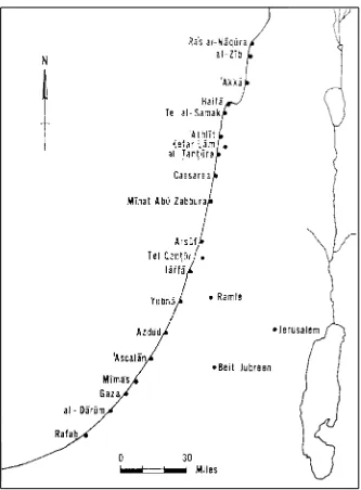
Dispersed over a narrow strip of one hundred and
À
fty miles, the twenty
coastal watch-stations,
ribâts
and
mihrâses
of Palestine are located on small hills
near the sea (
)L
gure 3).
15) Some watch-stations were built near natural or
arti-À
cial anchorages, and estuaries, such as the
mihrâses
at Mînat Abû Zabbûra
(Tel Mikhmoret), located 6 miles south of Caesarea, and Tel Qantûr (Tel
Michal), located 2.25 miles south of the Islamic port city of Arsûf (modern Herzliya).
Chronologically, these
mihrâses
dated from the early Islamic period
(13/634-493/1099). Archeological excavations at both sites discovered that the
mihrâs
was a square building with one preserved
Á
oor strengthened by eight buttresses,
two in each corner. According to the archeological reports, the general dimensions
of the interior was 18.3 by 18.3 feet, and each of the walls measured 22.5 by
3.66 feet (
)L
gures 4
DQG
5).
16) Although archeological evidence is necessarily
13) Cahen 1978, pp. 307-308. 14) Udovitch 1978, p. 541.
15) A simple calculation shows that the ribâtsand mihrâses along the Palestinian coast were built at set distances. The average distance between each watch-station was roughly 7.5 miles. A combination of the archeological evidence and the Geniza documents would help us to conceive the role of watch-stations in protecting ships sailing along the coast. Based on the Geniza papers, Goitein calculated that the duration of a maritime voyage from Acre to Jaffa was on average Àve days. Between these two port cities, there were only two major
ports, Caesarea and Arsûf, which could be reached by a commercial vessel in few days, and seven watch-stations. However, in case of unexpected enemy or pirate attack, commercial ships must have found shelter in the closest port or ribâtanchorage. Likewise, these anchor-ages also functioned as stationary points at night. For further details about the duration of sea voyages, see Goitein 1967a, vol. 1, pp. 325-326; Udovitch 1978, pp. 511-513.
silent about a tower’s height, written sources report that the
mihrâs
reached as
high as 75 feet.
17)
Two
ribâts
still stand in reasonably good condition on the coast of Palestine,
Kefer Lâm (ha-Bonîm) and Azdûd (Ashdod). The geographical location and the
dimensions of these two
ribâts
differ from each other. The former, situated ten
miles north of Caesarea, three miles north of Tantûra (Dor), and six miles south
of ÆAthlît, was built on a high hill (90 feet above sea level), a half mile from
the sea. The
ribât
(159 by 102 feet) has four projecting circular towers at the
corners and two semicircular towers
Á
anking the entrance in the southern side,
in addition to sixteen buttresses supporting the eastern, western, and northern
walls (
)L
gure 6). As usual, it includes a cistern, storehouses for provisions,
magazines for arms, and a tower for signaling.
18) Despite its proximity to the
sea, the
ribât
was built in close vicinity to a natural anchorage in which,
pre-sumably, a few ships could
À
nd shelter from maritime raids or inclement
weather.
Situated on the Mediterranean shore ten miles north of ÆAscalân (Ascalon),
the watch-station at Azdûd (180 by 135 feet) is slightly larger than the fortress
at Kefer Lâm (
)L
gure 7). The external appearance of the
ribât
, particularly its
west wall, facing the sea, raises the question of the civilian function of the
coastal forti
À
cations. This wall contains of two three-quarter towers in the
north-western and southnorth-western corners, and two semicircular towers alongside the
pier overlooking the sea. The fortress’s north, east, and south walls are
sup-ported by buttresses built at measured distances, with two projecting square
towers in the northeastern and southeastern corners, and two semicircular towers
Á
anking the main entrance in the eastern facade. As in other Islamic
ribâts
, the
archeologists excavated a residential unit, stable, magazines, and storehouses.
19)
17) BalbaÆ 1968, p. 51.
18) Hadashot Archeologiot 17 (1966), p. 17; Hadashot Archeologiot 33 (1970), p. 11; Benvenisti 1984, pp. 219-221. He contends that this fortress was founded by a French noble family during the early years of the Crusaders in the Levant. His assumption must be incor-rect since similar architectural designs and plans are found in Qasr al-Mushattâ (Jordan), the
ribâtsof Sûsa and Monastîr (Tunisia), and the ribât of Azdûd (Palestine), all of which are mentioned by al-Muqaddasî in the tenth century C.E. More interestingly, medieval sources from the early Islamic period provide more details regarding the history of the site and indi-cate that the Umayyad caliph Hishâm Ibn ÆAbd al-Malik established the settlement of Kefer Lâm. For further historical details, see Yâqût, MuÆjam al-Buldân, vol. 4, p. 470; SamÆânî, Al-Ansâb, vol. 5, p. 671; Marmardji 1951, p. 175.
According to the archeological reports, the pier was built to facilitate access to
the
murâbitûn
who periodically patrolled the coasts.
20) Since the watch-station
at Azdûd was established in an intermediary port, it is possible that the pier was
also intended to provide assistance and shelter to commercial ships sailing along
the coast in the event of hostile attacks.
21)
Historical accounts and jurisprudential inquiries substantiate the hypothesis
that garrisons at the
ribâts
and
mihrâses
were obligated to provide assistance to
commercial ships confronted by hostile attacks.
22) At present there are three
known references dealing exclusively with the role of the
ribât
institution in
providing assistance and refuge to seacrafts. Muhammad Ibn ÆAlî al-Mâzarî
writes:
A merchant gave a sailor Almoravid dînârs in the form of a qirâd (commenda) to travel to Sicily. The capitalist (i.e., the merchant) went away and, upon his return, called the sailor to account. The sailor declared having borrowed a light boat [qârib latîf] other than the one usually took for his journeys between Sicily and Ifrîqiyya. The passengers had been warned of the proximity of the enemy by the occupants of a citadel [hisn] named al-Rukâm and the sailor had abandoned ship, taking all his belongings, more particularly the merchandise bought with the capitalist’s dînârs
and had entrusted the commanding ofÀcer [qâæid] of the place in question with
them. . . . .23)
Additional documentary evidence that substantiates this argument is found in
the commercial privileges granted by the Mamlûk
sultân
Qâitbây (872-901/
1468-1496) to the Republic of
)O
orence in 1497 C.E. Article twenty-four of the
treaty states:
XXIV. The aforesaid envoy has asked that when one of the ships of the aforesaid
Áorentines enters one of the fortressesof our noble stationand treachery has befallen
the aforesaid ship, it should be favored with what it needs for repulsion of the enemy. So let his honorable Excellency promulgate his exalted command that when one of the
20) Conder and Kitchner 1882, vol. 2, pp. 422, 426-427; Le Strange 1965, p. 405;
Benvenisti 1984, pp. 219-220; Hadashot Archeologiot 33 (1970) pp. 26-27; Kloner and
Birman 1973/4, pp. 21-24; Peiphano 1986, pp. 23-24.
Although typically stationed in major strategic ports, the Áeet with its galleys and warships
was under certain circumstances concentrated in the ribâts’ anchorages. In 585/1189 when the European Áeets blockaded Acre, the navy of Saladin which was stationed in the ribâtof
al-Zîb (Akhzîv), ten miles north of Acre, was able to break through the European naval blockade and supply the city by sea. The intermediary stations [ribâts] of Haifa and al-Zîb played an essential role in defending the coastal frontiers and providing immediate assistance to the Palestinian port cities during the early Crusades. Abû Shâma Al-Rawdatayn, vol. 2, pp. 181-184; ÆAbbâdy and Sâlem 1981, pp. 284-285; Ehrenkreutz 1955, pp. 112-113.
21) BalbaÆ 1968, p. 39.
Áorentines’ ships enters one of the fortressesof Islam and treachery from enemies has
befallen it, it shall be favored with what it needs for repulsion of the enemy, the cost and expense falling to the ship’s master.24)
The commander of the fortress was held responsible for storing and
protect-ing the cargo and properties of Muslim and non-Muslim merchants sailprotect-ing in
Islamic vessels. He was not entitled to be remunerated for assistance provided
to the passengers and merchants aboard the vessel. In principle, the act of
assis-tance as re
Á
ected by Islamic law must be considered as a religious duty.
25)
Nonetheless, when Muslim governments suffered
À
nancial crises, the ship’s
master was charged for the protection of the ship and its contents.
While the biographies of Muslim scholars shed little light on the identity of
the proprietors of seagoing vessels, the Geniza papers report that these vessels
were owned by persons connected with government: the
sultân
himself,
mem-bers of the royal household, governors [
qâæids
and
amîrs
], military commanders,
viziers, and Muslim judges, in addition to well-to-do Muslims and Jews. The
shipping business was regarded as one of the most pro
À
table investments.
26)
Therefore, the government took on the responsibility to physically maintain the
coastal defense system and to secure the navigational lanes by providing naval
escorts as a protection against pirate and enemy attacks and by stationing
arma-das and garrisons along the coastal routes.
27) As Ibn Mammâtî (544-606/
1149-1209), the Ayyûbîd vizier, writes:
In the month of Barmahât28) . . . which coincides with the beginning of the spring, commercial ships head for the Mediterranean Sea from the Egyptian districts, the Maghrib, and Byzantium. During this month [the government] looks after concentrating the garisons in the protected frontiers, and preparing the victorious battleships to defend them.29)
While our sources give mainly religious motivations for fortifying the coasts
and securing the maritime lanes, the government’s concern was certainly
eco-nomic. The fact that warships [
harbîs
] served, apparently on a fairly regular
basis, as commercial carriers con
À
rms the government’s interest and
involve-ment in the shipping business. Securing the maritime lanes must have created
favorable conditions to expand the overseas trade, thereby increasing the tax
24) Wansbrough 1965, p. 519; for the Arabic text see pp. 504-505.
25) Wansharîsî, Al-MiÆyâr, vol. 8, pp. 302-304; Ibn Rushd, Al-Bayân wal-Tahsîl, vol. 3, pp. 61-62.
26) Goitein 1967a, vol. 1, pp. 309-313; Udovitch 1978, pp. 519-521. 27) BalbaÆ 1968, p. 34.
revenues and the income of the proprietors of commercial vessels, which were
largely owned by persons associated with the government.
The establishment of watchtowers along the coastal lanes extended beyond
the Mediterranean region. The ÆAbbâsîd caliphate in the East erected
watch-towers and lighthouses along the shores as guides for coasting pilots and to
secure the maritime routes.
30) Nâsîr-î Khosraw (395-481/1004-1088) vividly
de-scribed the watchtowers situated between Basra and ÆAbbâdân, stating:
At dawn something like a small bird could be seen on the sea. The closer we ap-proached, the larger it appeared. When it was about one parasang to our left, an adverse wind came up so they dropped anchor and took down the sail. I asked what that thing was and was told that it was called a “khashshâb.” It consisted of four enor-mous wooden posts made of teak and was shaped something like a war machine, squarish, wide at the base and narrow at the top. It was about forty ells above the sur-face of the water and had tile and stone on top held together by wood so as to form a kind of ceiling. On top of that were four arched openings where a sentinel could be stationed. Some said this khashshâbhad been constructed by a rich merchant, others that a king had it made. It served two functions: Àrst, that area was being silted and
the sea consequently becoming shallow so that if a large ship chanced to pass, it would strike the bottom. At night lamps encased in glass (so that the wind would not blow them out) were lit for people to see from afar and take precaution, since there was no possibility of rescue. Second, one could know the extent of the land and, if there were thieves, steer a ship away. When the khashshâb was no longer visible, another one of the same shape came into view; but this one did not have the watch-tower on top, as though it had not been Ànished.31)
The
ribât
institution functioned as
observation points
for ships sailing along
the coasts. The choice of their topographical locations was not accidental. Most
ribâts
and
mihrâses
were built in measured distances, situated in close vicinity
to natural or arti
À
cial anchorages, and on small hills. Functioning as
precau-tionary guides for pilots sailing along the coast, the lighthouses were erected
near shallow waters and coral reefs. These establishments were placed at
mili-tary strongholds in order to protect the coastal frontiers and commercial
ves-sels from hostile raids. The architectural plan of the
ribât
, which consists of
living quarters, storage facilities for arms and food, and magazines,
substanti-ates the idea that this institution may have provided assistance to commercial
ships when needed. Like af
Á
uent merchants, members of governmental circles,
owing to their involvement in the shipping business, were concerned to secure
the maritime lanes and protect commercial ships from enemy or pirate attacks.
30) Nâjî 1988, p. 177; Barrâwî 1948, pp. 295-297.
31) Nâsîr-î Khosraw, Book of Travels (Safarnâma), p. 96. Describing the stockades [ kha-shabât] near the port city of Basrah, ÆIrâq, al-Muqaddasî reported: “This is by far the great-est evil, a strait and a shallow combined. Here small huts have been erected on palm trunks set in the sea, and people stationed therein to keep a Àne lighted at night, as a warning to
BIBLIOGRAPHY
Primary Sources
Abû Shâma, ÆAbd al-Rahmân Ibn IsmâÆîl (d. 665/1268)
1870 Kitâb al-Rawdatayn fî Akhbâr al-Dawlatayn al-Nuwriyya wal-Salâhiyya. 2 vols. Cairo.
Ibn Mammâtî, al-AsÆad Abû al-Makârim (544-606/1149-1209) 1943 Qawânîn al-Dawâwîn, ed. by ÆAzîz Suryal ÆAtiya, Cairo.
Ibn Rushd, Abî al-Walîd Muhammad Ibn Ahmad al-Qurtubî (450-520/1058-1126)
1984 Al-Bayân wal-Tahsîl wal-Sharh wal-Tawjîh wal-TaÆlîl fî Masâæil al-Mustakhraja. 20 vols. (Beirut: Dâr al-Gharb al-Islâmî).
Maqqarî, Shahâb al-Dîn Abû al-ÆAbbâs Ahmad Ibn Muhammad (d. 1041/1631)
1884 Nafh al-Tîb min Ghusni Andalus al-Ratîb. 10 vols. (ed. Muhammad Muhyi al-Dîn ÆAbd al-Hamîd, Cairo).
Maqrîzî, Taqiyy al-Dîn Ahmad Ibn ÆAlî (766-845/1364-1442)
1967 Al-MawâÆiz wal-IÆtibbâr fî Dhikr al-Khitat wal-Âthâr. 2 vols. (Cairo: Muæassat al-Hâbî).
Muqaddasî, al-Bashshârî (336-380/947-990)
1897 Ahsan al-Taqâsîm fî MaÆrifat al-Aqâlîm. trans. and edited by G.S.A. Ranking and R.F. Azoo (Calcutta: The Asiatic Society of Bengal).
1906 Ahsan al-Taqâsîm fî MaÆrifat al-Aqâlîm, ed. M.J. De Goeje (Leiden: Brill). Nâsîr-î Khosraw (395-481/1004-1088)
1986 Book of Travels (Safarnâma)(New York: State University of New York Press). Qalqashandî, Abî al-ÆAbbâs Ahmad (d. 823/1418)
1913 Subh al-AÆshâ fî SinâÆat al-Inshâæ. 14 vols. (Cairo: Al-MatbaÆa al-Amîriyya). SamÆânî, ÆAbd al-Karîm Ibn Muhammad (507-562/1113-1166)
1988 Al-Ansâb. 5 vols. (Beirut: Dâr al-Janân). Wansharîsî, Abî al-ÆAbbâs Ahmad Ibn Yahyâ (d. 914/1508)
1981 Al-MiÆyâr al-MuÆrib wal-JâmiÆ al-Mughrib Æan Fatâwâ Ahl Ifrîqiyya wal-Andalus wal-Maghrib. 13 vols. (Beirut: Dâr al-Gharb al-Islâmî).
Yâqût Ibn ÆAbd Allâh al-Hamawî (575-627/1179-1229)
1957 Kitâb MuÆjam al-Buldân. 5 vols. (Beirut: Dâr Sâder).
Secondary Sources
ÆAbbâdy, Mokhtâr, and Elsayyed ÆAbd al-ÆAzîz Sâlem
1981 Târîkh al-Bahriyya al-Islâmiyya fî Misr wal-Shâm (Beirut: Dâr Nahda al-ÆArabiyya).
BalbaÆ, Muhammad
1968 “Nashæat Ribât wa-Tatawuruhu wa-Ahammiyyat Murâbata fî Târîkh al-Muslimîn.” Dirâsât Athariyya wa-Târîkhiyya2: 27-76.
Barrâwî, Râshid
1948 Hâlat Misr al-Iqtisâdiyya fî ÆAhd al-Fâtimiyyîn (Cairo: Maktabat Nahda al-Misriyya).
Bashear, Suliman
1991 “Apocalyptic and other Materials on Early Muslim-Byzantine Wars; A Review of Arabic Sources.”Journal of the Royal Asiatic Society, third series 1.2: 173-207. Benvenisti, Miron
1984 “ÆArei Eretz Yisrael ba-Tequfa ha-Tzalbanit.” Qardom 35-36: 219-221. Cahen, Claude
Croisades.” In La Navigazione Mediterranea nell’alto Medioevo(Spoleto: Centro Italiano di Studi sull’alto Medioevo), pp. 299-319.
Conder, R., and R. Kitchner
1882 The Survey of Western Palestine(London: Palestine Exploration Fund). Creswell, K.A.
1989 A Short Account of Early Muslim Architecture(Cairo: American University in Cairo Press).
Ehrenkreutz, A.S.
1955 “The Place of Saladin in the Naval History of the Mediterranean Sea in the
Middle Ages.” Journal of the American Oriental Society 72.2: 100-116. ElÆad, ÆAmikam
1982 “The Coastal Cities of Palestine During the Early Middle Ages.” The
Jeru-salem Cathedra 2: 146-167. Darâdkeh, Sâlih
1991 “Al-Barîd wa-Turuq al-Muwâsalât fî Bilâd al-Shâm fî al-ÆAsr al-ÆAbbâsî.”
Bilâd al-Shâm during the ÆAbbâsîd Period (132/750-451/1059); Proceedings of the Fifth International Conference on the History of Bilâd al-Shâm (Ammân: The Bilad al-Sham History Committee), pp. 191-210.
Goitein, S.D.
1967a A Mediterranean Society: The Jewish Communities of the Arab World as
Por-trayed in the Documents of the Cairo Geniza: Economic Foundation (Berkeley: University of California Press).
1967b “Mishar ha-Yehudim ba-Yam ha-Tikhon bi-Tehilat ha-Meæah ha-Ahat ÆEsreh.”
Tarbiz 37.1: 366-395; 37.2: 48-77; 37.3: 158-190.
1973 Letters of Medieval Jewish Traders (Princeton: Princeton University Press). Herzog, Zeev, et al.
1977 “Excavations at Tel Michal, 1977.” Tel Aviv5: 99-130.
1989 Excavations at Tel Michal, Israel (Minneapolis: The University of Minnesota Press).
Idris, Hady Roger
1961 “Commerce maritime et Kirâd en Berbérie Orientale: d’après un recueil inédit de fatwâs médiévales.” Journal of the Economic and Social History of the Orient 4: 223-239.
1992 La Berbérie Orientale sous les Zirides Xe-XIIe siécle. 2 vols. Translated and edited into Arabic by Hamadi Sahli. (Beirut: Dâr al-Gharb al-Islâmî). Khaddûrî, Majîd
1973 Al-Harb wal-Silm fî SharÆat al-Islâm(Beirut: Al-Dâr al-Muttahida lil-Nashr). Kloner, ÆAmos and Ariel Birman
1973/4 “Toldoteha shel Ashdod Yam.” TevaÆ ve-Aretz16: 21-24. Le Strange, Guy
1965 Palestine Under the Moslems (Beirut: Khayats). Marçais, George
1936 “Ribât.” The Encyclopaedia of Islam 3: 1150-1151.
Marmardji, O.P.
1951 Textes geographiques arabes sur le Palestine(Paris: Lecoffre). Nâjî, ÆAbd al-Jabbâr
1988 “Dirâsa Muqârana lil-Ahwâl al-Tijâriyya li-Mawâni al-Khalîj al-Arabî
wal-Jazîra al-ÆArabiyya fî al-Qarn al-RâbiÆ al-Hijrî.” Majallat Dirâsât al-Khalîj wal-Jazîra al-Arabiyya14: 173-198.
Peiphano, Shelomo
1986 “Metzoda ÆAravit Æal Hof ha-Yam.” TevaÆ ve-Aretz 28: 23-24. Purath, Yousef, et al.
Sâlem, Elsayyed ÆAbd al-ÆAzîz, and Mokhtâr ÆAbbâdy
1969 Târîkh al-Bahriyya al-Islâmiyya fî al-Maghrib wal-Andalus(Beirut: Dâr al-Nahda al-ÆArabiyya).
Udovitch, A.L.
1978 “Time, the Sea and Society: Duration of Commercial Voyages on the Southern Shores of the Mediterranean during the High Middle Ages.” In La Navigazione Mediterranea nell’Alto Medioevo (Spoleto: Centro Italiano di Studi sull’alto Medioevo), pp. 503-563.
Wansbrough, John
1965 “Venice and )Oorence in the Mamluk Commercial Privileges.” Bulletin of the
RIBÂT
SYSTEM AND ITS ROLE IN COASTAL NAVIGATION
223
Figure 1: Reconstructed ground plan of the ribâflat Sûsa, Tunisia.
Source: K.A. Creswell, A Short Account of Early Muslim Architecture.
Figure 2: Reconstructed ground plan of the ribâfl at Monastîr, Tunisia.
Figure 4: Archeological remains of the
miΩrâsat Mînat Abû Zabbûra. Source: Y. Purath, Qadmoniot ÆEmeq ºefer.
Figure 5: Archeological remains of the
miΩrâsat Tel Qanflûr. Source: Z. Herzog, Excavation at
Tel Michal.
Figure 7: Architectural plan of the
ribâflat Azdûd.
Source: A. Kloner and A. Berman,