Soutlutast Asian Studies, Vol. 26, No.3, December 1988
Studies on Peat in the Coastal Plains
of Sumatra and Borneo
Part I: Physiography and Geomorphology
of the Coastal Plains
SUPIANDI Sabiham
*
Abstract
The physiography and geomorphology of the coastal plains in Jambi and South Kalimantan were studied with the aim of describing the recent sediments deposited there. For this purpose, borings were made along transects from inland to the coast to a depth of up to 6 meters.
The results of these studies indicate the presence of five physiographic regions and fifteen geomorphic units in the coastal plain of Jambi. In the coastal plain of South Kalimantan, four physiographic regions and eleven geomorphic units were established.
The landforms in both of these coastal plains were developed by peat and mineral soil deposits. These deposits started to accumulate during the Holocene period. In Jambi, peats situated in the ombrogenous peats zone, which sometimes exceed 6 meters in depth, have been deposited since the terrestrial soils on the Pleistocene terrace were transformed into fluviatile swampy soils to form the so-called peat-capped terrace. Peats on mangrove deposits situated in the riverine to brackish deposits zone were formed in later periods. In the brackish to marine deposits zone, the thin peats are very young.
InSouthKalimantan, peats situated in the riverine to brackish deposits zone have been deposited on mangrove deposits and on sand or gravel. I believe that the peat formation on sand or gravel is of the same age as the older peat in Jambi.
Introduction
Since the 1930s, soil scientists have demon-strated the presence of peats in the coastal plains of Insular Southeast Asia. However, the geomorphic process of peat development in the plains of Indonesian river basins was not clear, and available data on landform development were limited. Therefore, I examined the peats
*
Department of Soil Sciences, Bogor Agricultural University, Bogor, Indonesiaand the physiography and geomorphology of recent sediments along the Batang Hari riverin Jambi, Sumatra and the Barito river in South Kalimantan, Borneo.
have gradually developed into thick,
dome-shaped formations of ombrogenous lowland peat. The study of these peat deposits was
divided into four parts, of which the results are presented in separate papers. Part one
pre-sents the physiography and geomorphology of the coastal plains in ]ambi, Sumatra and South
Kalimantan, Borneo. Part two describes the clay mineral composition in order to
differen-tiate the sediments which underlie the peat
deposits. Part three is a micromorphological study of peats, which aims to characterize the
micromorphology of peats at varying stages of decomposition. Part four describes the floral
composition of peat in the coastal plains of
Brunei in order to study the vegetational change from the basal clay to the present-day
forest on the basis of pollen analysis.
Part one, presented in this paper, discusses
Site Studied
o
200 400 600 800 1000Gセ[[[[[[[[iG][[[[[[[[[ZゥG[[[[Z]Z]ZエZG =;:;;;;!;;;;'= =
km
the collected data on the physiography and
geomorphology of the Sumatra and Kalimantan coasts.
Field Studies and Sampling
Field study in the coastal plains of ]ambi was
carried out along the Batang Hari river from October to November, 1983, and in South
Kalimantan along the Barito river from August
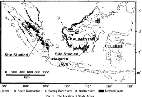
to September, 1985. Site maps of the study area are illustrated in Fig. l.
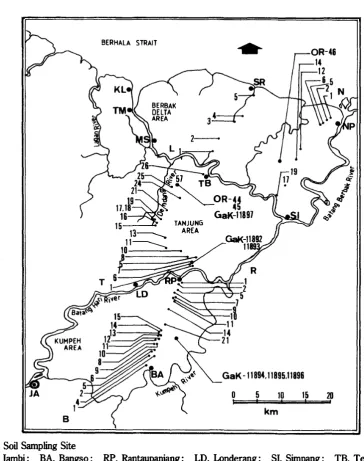
In]ambi, field study was concentrated in the Kumpeh, the Tanjung, the Dendang and the
Berbak Delta areas (Fig. 2). In the center of the Kumpeh and Tanjung areas, dense forest still covers most of the deep peats. In the
Dendang and the Berbak Delta areas, however,
the land is used mainly for rice cultivation.
950
1000
1050
1100
1150 A, Jambi; B, South Kalimantan; 1, Batang Haririver; 2, Baritoriver;
Fig. 1 The LocationofStudy Areas
1200
[image:3.597.72.529.430.742.2]GaK -11894.11895.11896 BERHAlA STRAIT
10 15
.
20km
5,
o
1 R
セセセrQ
セセTM
_ _152• : SoilSampling Site
JA, Jambi; BA, Bangso; RP, Rantaupanjang; LD, Londerang; SI, Simpang; TB, Telukbuan; MS, Muarasabak; TM, Telukmajelis; KL, Kampung)aut; SR, Simburnaik; NP, Nipahpanjang
Fig. 2 Field Study Area in the Coastal Plain of Jambi
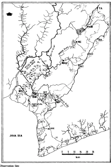
In
South Kalimantan, field study was con-ducted in the Pulau Petak Delta and the Marta-pura areas (Fig. 3). The coastal plain in South Kalimantan has almost entirely been exploitedfor paddy growing.
In
both of the study areas, soil borings were made along transects at intervals 0.5 to 2.0kmto a depth of up to 6 meters. The soil prop-erties observed were color, texture,
consis-tency and the depth of organic matter.
[image:4.599.101.466.95.557.2]JAVA SEA
o
5, 10; 15km
20 25
• : Soil Observation Site
AT, Anjir Tamban (Tamban canal); AS, Anjir Sarapat; ATL,Anjir Talaran; BM, Banjannasin; MP, Martapura; RT, Rantau; KD, Kandangan; BA, Barabai; TA, Tanjung; AM, Amuntai; F, Folder of Alabio; NE, Negara; MAS, Margasari; MS, Mekarsari; PH, Pleihari; KI, Kintap; G, Gambut; ST, Sei Tabuk
[image:5.607.103.495.102.690.2]staff of the Herbarium Bogoriense.
14C-datings were done at Gakushuin Uni-versity, Tokyo (GaK) and the Radiation Center
of Osaka Prefecture, Osaka (OR).
The degree of decomposition of peats was
ascertained by detennination of the humification degree [Kalla 1956]. A colorimetric method
based on the extraction of air-dried and ground peat samples with 0.025M Na-phyrophosphate
was used for this detennination.
Physiographic Regions of Coastal Plains
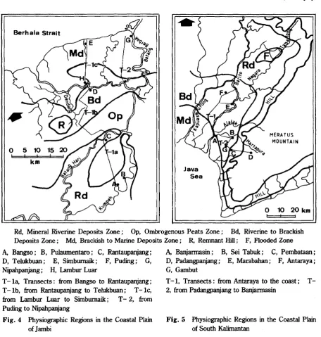
Physiographic regions of study areas in the coastal plains of Jambi and South Kalimantan are delineated as shown in Fig. 4 and 5,
respec-tively. They are based on the author's field
observations, with supplementary information from air photos and topographic maps. Based on the results of field observations, the
phys-Berh ala Strait
o
5 10! ! ,
km
Java Sea
MERATUS MOUNTAIN
o
10 20 km I IRd, Mineral Riverine Deposits Zone; Op, Ombrogenous Peats Zone; Bd, Riverine to Brackish Deposits Zone; Md, Brackish to Marine Deposits Zone; R, Remnant Hill ; F, Flooded Zone
A, Bangso; B, Pulaumentaro; C, Rantaupanjang; D, Telukbuan; E, Simburnaik; F, Puding; G, Nipahpanjang; H, Lambur Luar
T- la, Transects: from Bangso to Rantaupanjang; T-lb, from Rantaupanjang to Telukbuan; T-lc, from Lambur Luar to Simburnaik; T- 2, from Puding to Nipahpanjang
Fig. 4 Physiographic Regions in the Coastal Plain of]ambi
A, Banjannasin; B, Sei Tabuk; C, Pembataan; D, Padangpanjang; E, Marabahan; F, Antaraya; G, Gambut
T-1, Transects: from Antaraya to the coast; T-2, from Padangpanjang to Banjannasin
[image:6.596.68.525.267.746.2]iographic regions of these plains are obviously
related to the vegetation types, hydrography of main rivers, topography and human influence.
Since the present vegetation was observed along the transects, the observed patterns can
be interpreted as being characteristic vegeta-tion types. The present vegetavegeta-tion in the coastal plains of Jambi can be divided into five types:
(i) freshwater-swamp forest, which occurs mainly near the rivers; (ii) peat-swamp forest,
which normally starts about 2 to 5km distance from the rivers; (iii) riverine forest covering
the levees along the rivers; (iv) present man-grove forest; and (v) present beach forest
covering the coastline. In the following discus-sion, only commonly occurring species are
mentioned in the characterization of these vegetation types. It cannot be ruled out that
rare species are typical of certain vegetation
types.
The freshwater-swamp forest is
character-ized by Alstonia pneumatophora in the upper storey, and Antidesma spicatum in the under
storey. In the peat-swamp forest, the palm
Licuala acutijidaandPandanussp. grow well in
the undergrowth, and Koompassia malaccensis
andShorea sp. in the upper storey.
Inthe riverine forest, I had some difficulty in
studying the vegetation type, because I always
started to observe the soils and vegetation from villages situated on the natural levees. Species
like Eugenia sp. and CallojJhyllum sp., which
are normally associated with riverine forest,
were seldom found in the area around the villages, where almost all of the land had been
cleared for fruit trees or rubber gardens, and no extensive riverine forest remained.
The present mangrove and beach forests are characterized by the presence of only a few
species, because the local people have success-fully exploited this area for coconut plantation
and rice cultivation. RhizojJhora sp. normally dominates the present mangrove forest. In the present beach forest, Avicennia sp. is
dominant.
In South Kalimantan only beach forest and small areas of mangrove forest remain, which
are dominated byAvicenniasp. andRhizophora
sp., respectively. In more open mangrove
forest, the fern Acrostichum sp. may occur in the undergrowth. On the levees along the river
estuaries, very few Sonneratia sp. sometimes with Nipa sp. were found. However, the
freshwater-swamp and peat-swamp forests were already devastated. Likewise, the
river-ine forests have almost completely disappeared, having been cleared for settlement. After the
completion of drainage canals, the soils
gradually dry out, causing loss of peat and release of sulfate acidity (pH oxidation!) 1),
which eventually hamper crop growth. This is evidenced by the extensive areas of the
abandoned agricultural lands, which are now covered by gelam (Melaleuca leucadendron)
trees, and by Acrostichum aureum and
E leocharis dulcis in the undergrowth.
In some places around Anjir Tamban and
Anjir Sarapat (Tamban and Sarapat canals)
rubber plantations remain. In fact, exploitation of the coastal plain for paddy and rubber in
South Kalimantan started after the construction of the Ulin road in the 1920s and Anjir Tamban
and Anjir Sarapat in the 1930s.
The hydrography ofmain rivers is
character-ized by two types of water level fluctuation: ( i ) daily fluctuation near the coastline; and (ii)
1) pH oxidation was measured after the sample was
annual fluctuation inland. The water level fluctuations in these rivers are influenced by
rainfall and tidal action, and play an important
role in determining the nature of sediments. Furukawa and Supiandi [1985] reported that
the water level of Batang Hari river around Telukmajelis in the estuary is characterized by daily fluctuation. The difference in water level between high and low tides is about 3.0 m.
This means that at high tide, the area near the sea is probably inundated by sediment-bearing
brackish water, and at low tide these sediments
are deposited on the soil surface.
In contrast, the river level around Londrang (about 80kIn from the coastline) is
character-ized by annual fluctuation. In the rainy season (November to January), even at low tide, the water level rose to about 3.0 m. In the dry season, however, the water levels at high and low tide were about -0.5 and -1.5 m,
respec-tively. This means the area near the river, was
mostly inundated by freshwater during the rainy season.
In South Kalimantan, the water movement around the Pulau Petak Delta and the
Marta-pura areas is largely governed by daily fluctua-tion. Due to the area's low elevation, the water
level fluctuation in these rivers is very impor-tant for all aspects of life. When the water levels are high, the rivers overflow their banks
and flood the adjacent land through numerous small streams. This means that during high
water, these areas are mostly inundated. In the
dry season, brackish water probably inundates
these areas athightide.
In the area near to the Polder Alabio, the river level is characterized by annual
fluctua-tion. During the rainy season (September to March), this area is mostly influenced by
freshwater flooding.
The coastal plains of Jambi and South
Kali-mantan have a flat topography, except remnant
hill near the Dendang river in Jambi and the Meratus mountaininSouth Kalimantan.
A description of the physiographic regions in
the coastal plains of Jambi and South Kalimantan is presented below.
Jambi
The coastal plain of Jambican be divided into
five physiographic regions as shown in Table 1 and Fig. 4.
Mineral Riverine Deposits Zone
This zone mostly covers the Kumpeh area
along the Batang Hari and Kumpeh rivers. The elevation of this zone is about 4.0 to 5.5 m above mean sea level (MSL) along the Kumpeh
river, and about3.0 to 5.0 m above MSL along the Batang Hari river. The important factor in
the sedimentation here is the slow accumulation of sediments in a belt stretching parallel to the
rivers. These sediments are mainly trans-ported by the rivers during high water. Those deposited near the rivers form the natural
levees. During the rainy season, the area behind the levees is mostly covered by
fresh-water flooding.
Both banks of the Batang Hari river are generally 2.0 to 3.0 m higher thanbackswamps
and are utilized for rubber and fruit gardens. Along the Kumpeh river, however, the levees lie about 0.5 to 1.0 m lower than the
back-swamps. Almost all of the backswamps are used for rice cultivation during the rainy season.
Vegetation cover is characterized by ex-tremely few species, like Alstonia
pneuma-tophora, Eugenia
sp.,Koompassia malaccensis
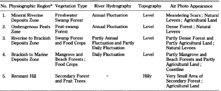
Table 1 Physiographic Regions of the Coastal Plain of Jambi: Vegetation Types, River
Hydrography, Topography, andAir Photo Appearance No. Physiographic Region* Vegetation Type River Hydrography Topography
1. Mineral Riverine Freshwater Annual Fluctuation Level Deposits Zone Swamp Forest
2. Ombrogenous Peats Peat-swamp Annual Fluctuation Level
Zone Forest
3. Riverine to Brackish Swamp Forest Partly Annual Level Deposits Zone and Food Crops Fluctuation and Partly
Daily Fluctuation
4. Brackish to Marine Mangrove and Daily Fluctuation Level Deposits Zone Beach Forests;
Food Crops
5. Remnant Hill Secondary Forest and Fruit Trees
Hilly
Air Photo Appearance
Meandering Scars; Natural Levees; Agricultural Land Dense Forest; Natural Levees
Partly Dense Forest and Partly Agricultural Land; Natural Levees
Partly Mangrove and Beach Forests and Partly Agricultural Land ; Coastline
Very Small Area of Secondary Forest; Agricultural Land
*
Modified after Furukawa and Supiandi [1985].the grassalang-alang (lmperata cylindrica) may occur in the undergrowth.
Ombrogenous Peats Zone
This zone is characterized by the presence of
deep peat, and is covered by dense forest. The elevation of the summit of peat deposits is
about 7.0 m above MSL. Many tree species grow well here, including Koompassia malaccensis,
Durio carinatus, jackia ornata, Tetramerista
glabra, SJwrea sp., Eugenia sp., E. acumina-tissima, E. cJavamyrlus, E. cJavijloraandDyera
sp.; and Licuala acutifida may occur in the undergrowth. In places, the original vegetation of peat-swamp forest has disappeared due to
human influence. People extracted useful trees of high commercial value, like Shorea sp. ,
jackia ornata, Durio carinatusandTetramerista glabra.
Peat deposits here accumulate under stag-nant fresh water supplied by riverfiood.
Verti-cal peat groWth led to gradually drier conditions and less frequent flooding, so the peats became rain-dependent to form the ombrogenous-peat
domes. Andriesse [1974] suggested that the
peats developed from the center of the peat dome (with older peat) towards the edge of the
dome. 14C-dating shows the ombrogenous-peat
in the Tanjung area to be older than that in the Kumpeh area. Since these peat deposits were
formed under the influence of inundation, these
14C_dating data clearly indicate that, during the transgression period, water stagnation took
place much later in the Kumpeh area than in the Tanjung area. This is supported by the fact that the Kumpeh area lies further from the sea.
The natural levees lie about 2.0 m below the summit of the peat dome, but higher than terrestrial soil surface underlying the peat.
Water stagnation on this saucer-shaped topography hampered the decomposition of
organic matter and caused the peat deposits to be formed.
Riverine
to
Brackish Deposits ZoneThis zone occupies the northern part of Tanjung and the southern part of the Berbak Delta. Its elevation is about 3.0 to 5.0 m about
MSL. Almost all of the zone is utilized for rice
area is still covered by dense forest containing many tree species, includingAlstonia
pneuma-tophora, Eugenia curranii, E. jamboloides, E.
zippeliana, Santina laevigata, and Scaphium macropodum. The grasses Cyperus platystylia
and Panicum incomtum and the fern Acros-tichum aureum were also found here in the
undergrowth.
In
former times, this zone was submerged by the sea during the transgression period. The intrusion of lagoonal sea formed mangrove deposits, which are now overlain bythin peats.Natural levees have developed along the Batang Hari and Dendang rivers with an eleva-tion of about 3.0 to 4.0 m above MSL. Around
the village of Telukbuan, former beach ridges
were found underlying the present natural
levee. During the transgression period, stag-nant water in the Dendang area containing large
amounts of sediments was dammed up by these
beach ridges, thereby increasing the sedimenta-tion which eventually formed the so-called
lagoon.
Brackish
to
Marine Deposits ZoneThis zone is situated along the coast of the Berbak Delta. Near the sea (up to about 0.5 kIn from the coastline), the process of deposi-tion is always influenced by marine acdeposi-tion, because this area lies near to MSL. At high
tide, the area covered by the present mangrove forest is almost completely covered by
salt-water, resulting in soils with high salinity. These soils are characterized by a sodium
saturation of more than 15 percent, and are grouped as Hallc Hydraquents with a neutral reaction in all layers (pH 5.9 to 6.1) and fine
clay texture [Institut Pertanian Bogor Team
1975]. Very few tree species remain. Only the present mangrove and beach forests cover the
coastal fringe.
Behind the present mangrove forest the elevation increases to about 2.0 to 3.0 m above
MSL. Large areas have been exploited for rice cultivation and coconut gardens, for which
purpose numerous canals have been dug across this zone by local people and the government.
The small canals dug by local people mostly
form so-called fish-bone channel networks. The
main function of these canals is to drain
floodwater and take in relatively good water
from the river in order to leach away of acids formed from organic matter deposits.
Remnant Hill
The monadnock in the Dendang area is an
outcrop of the Tertiary formation situated in the
middle of East Sumatra. Van Bemmelen [1949] states that downwarp of the pre-Tertiary
base-ment complex is filled with Neogen sedibase-ments which were folded in Plio-Pleistocene time.
During or after the main phase of folding, a dome was elevated, and during the period of
high sea level in the past this dome was probably an island.
This zone lies about 2kIn west of the Den-dang river, and it is exploited for upland crops.
In the valleys, however, the inhabitants
culti-vate the rice.
South Kalimantan
The coastal plain of South Kalimantan is
demarcated by the Kapuasmurung, Barito and Martapura rivers in the coastal area, and the Barito, Tabalong, Alabio, and Negara rivers
inland. This coastal plain can be divided into four physiographic regions (Table 2 and Fig. 5).
Mineral Riverine Deposits Zone
Table 2 Physiographic Regions of the Coastal Plain of SouthKalimantan: Vegetation Types, River Hydrography, Topography, andAirPhoto Appearance
No. Physiographic Region Vegetation Type River Hidrography* Topography Air Photo Appearance
l. Mineral Riverine Food Crops and Annual Fluctuation Level Meandering Scars; Natural
Deposits Zone Grasses Levees; Agricultural Land
2. Riverine to Brackish Food Crops; Partly Annual Level Secondary Forest; Natural Deposits Zone Gelam**and Fluctuation and Partly Levees; Agricultural Land
Grasses Daily Fluctuation
3. Brackish to Marine Mangrove and Daily Fluctuation Level Partly Mangrove and
Deposits Zone Beach Forests; Beach Forests and Partly
Food Crops; Secondary Forest;
Gelam Coastline; Agricultural
Land
4. Flooded Zone Grasses Annual Fluctuation Level Floodwater; Natural Levees
* Based on the author's field observations ** Melaleuca leucadendron
elevation is about 3.0 to 6.0 m above MSL.
The sediments deposited here are mainly trans-ported by these rivers.
Downstream from Amuntai to near the
Pol-der of Alabio, the Tabalong river becomes relatively narrow with banks about 3.0 to 4.0 m
high. The river carries large amounts of sedi-ments and has formed natural levees along both
banks. During the rainy season, a large volume
of river water spills over into the backswamps. When the flood begins to recede, rice is planted
in the backswamps. The vegetation types here
are mostly grasses with very few tree species. Along the Negara and Barito rivers, there are
also unbroken natural levees. In the back-swamps, there are stretches of the mineral
riverine deposits, which are sometimes covered by a thin layer of organic matter. These
swamps are used only for rice cultivation, from the time the flood recedes. During the rainy
season, the area becomes a broad expanse of
floodwater.
Riverine to Brackish Deposits Zone
This zone lies between Anjir Sarapat and the
Barito river near to Antaraya village in the
Pulau Petak Delta, and between Gambut village
and Banjarmasin in the Martapura area. Its elevation is about 2.0 to 3.0 m above MSL.
The banks of the Barito, Kapuasmurung and
Martapura rivers are about 0.5 m lower than the backswamps.
The Pulau Petak Delta was probably sub-merged during the transgression period due to
the rise in sea level. This is substantiated by the presence there of mangrove deposits, which sometimes underlie the peat deposits. In
the Martapura area, however, peat deposits cover the white coarse sand and gravel. Today,
this area is partly covered bygelam (Melaleuca
leucadendron)
and partly exploited for ricecultivation and coconut gardens. Itis traversed
by numerous canals dug by local people and the government. The main canals run
perpendic-ular to the rivers, and the secondary canals
perpendicular to the maincanals.
In the dry season, the large volume of brackish water in the river at high tide
in-fluences the backswamps. In the rainy season, however, a large volume of fresh water
Brackish
to Marine Deposits Zone
This zone occupies the coasts of the Pulau Petak Delta and the Martapura area. Lying near the sea, it has a flat topography through-out, with elevations varying from 2.0 to nearly
o
m above MSL. The sediments here are mainly categorized as mangrove deposits on tidal flat.The area near the coastline is influenced by seawater at high tide and is now covered by mangrove and beach forests. The area behind the mangrove forest is exploited for rice cultiva-tion.
This zone is also traversed by numerous canals dug by local people and the government for irrigation purposes. Near Anjir Tamban, people have tended to switch from rice cultiva-tion to coconut plantacultiva-tion because, according to local farmers, the soil productivity of paddy fields degrades after 5 or 6 years of paddy planting. This is supported by the fact that the area has been extensively farmed, and so many drainage canals (tertiary canals) have been cut that the soils dry out, which hampers the growth of rice. Inother places, around profile of BM- 8, abandoned agricultural lands had recovered secondary forest, which was domi-nated by tree species ofgelam, and by the fern
Acrostichum aureum
and the grassE leocharis
dulcis in the undergrowth.
Flooded Zone
This zone is roughly coterminous with the Pandamaan village. Its topography and its slight gradient towards the central depression cause floods in the center of the area, where the water depth is more than two meters in
all
seasons. During the rainy season (from September to March), flooding usually extends across the whole area.
This region is mostly used for fisheries. It has also been used for rice cultivation, known locally as
sawah
sela tahun.2) Here, people
start to plant rice in June-July.
Geomorphology of Coastal Plains
Geomo1jJhic Units and Stratigraphic Layers
Since soil borings from several observation points represented the same physiographic region, a one typical profile of each physio-graphic region was selected in order to describe the soil layers. Brief descriptions of soil profiles from each physiographic region are given
be-low. The descriptions include the number and location of the profile.
Table 3 shows the geomorphic units of the coastal plains of Jambi and South Kalimantan distributed successively from inland to the coast. The determination of these geomorphic units was based on the boring data and observa-tion of outcrops. Fifteen geomorphic units were established in Jambi, and 11 units in South Kalimantan.
Jambi
Diagrams of boring data have appeared in a former paper [Furukawa and Supiandi 1985]. The additional boring data presented here were taken from the transect T- 2 (Fig. 6). These boring data represent sediments formed by marine processes in the past.
Mineral riverine deposits zone.
Thesedi-ments contain, in the upper layer, light clay which is brown to grayish brown in color, and in the bottom layer, heavy clay which is grayish white with yellowish brown iron mottles.
2) Sawah sela tahun is a kind of rice cultivation in
Table 3 The Geomorphic Units of the Coastal Plains of Jambi and South Kalimantan
(10) Natural Levees
(11) Perennially Flooded Area
4. Flooded Zone
Physiographic Region Geomorphic Unit
l. Mineral Riverine (1) Natural Levees Deposits Zone (2) Meandering Scars
2. Riverine to (3) Peat-capped Brackish Deposits Mangrove Deposits Zone (4) Peat-capped Coarse
Sand and Gravel Deposits
(5) Natural Levees (6) Fonner Beach Ridges
3. Brackish to Marine (7) Mangrove Deposits Deposits Zone on Tidal Flat
(8) Former Thick Sand Ridges
(9) Mangrove Belt Covering the Present Coastline
(1) Natural Levees
(2) Meandering Scars
(3) Low Terrace
(14) Hillslopes
(15) Shallow Valley Bottoms
Jambi* South Kalimantan
Physiographic Region Geomorphic Unit
2. Ombrogenous (4) Peat-capped Terrace Peats Zone (5) Natural Levees
3. Riverine to (6) Terrestrial Soil on the Brackish Deposits Terrace
Zone (7) Intruding Mangrove on Peat-capped Terrace
(8) Mangrove Deposits on the Terrace
(9) Natural Levees
(10) Former Beach Ridges
4. Brackish to Marine (11) Mangrove Deposits on Deposits Zone Tidal Flat
(12) MangroveBeltCovering the Present Coastline
(13) Thick Sand Ridges
5. Remnant Hill 1. Mineral Riverine
Deposits Zone
* Modified after Furukawa and Supiandi [1985]
N
<.:\ 7 •...
18 19 :::'.8 16 17 _, 1 ;' 1 3 :;.:.::,. .... 5 ••.. 6
. . . 7
14 15 12 10 11 "-/' : : "- .. ; ' : :.. ... / ..
,
... 5 ...-,
..."
\- : :...(.\
• ... - / : :.:2:6 : ..
.. 5
"<:..,
.7
.-L,2j ..::
"': ...
--
:/..-セN 6 ..:\ .....
,
::---:-:.::.- :..:7
::.,
.:0:..•.
.:-y .... ::
9 8 7 :..:--" ':--..:... '-'-:
;:
6 _,1 ,,1セNセ[ 7 ( :
·8
5
4
3
- •. 7 :::: 6
3
2
o m
m:
Terrestrial Soils . : PeatsEJ:
Mangrove Deposits []: Sand Beach Deposits[g: Mangrove Deposits mixed with Fine Sand 8:Peaty Mineral * Numbers of soil layer
Fig. 6 Diagrams of Boring Data from the Coastal Plain of Jambi, from Purling to Nipahpanjang in the Brackish to Marine Deposits Zone
In this zone three geomorphic units were
found. Along the Batang
Hari
and Kumpeh rivers, (1) the natural levees have beende-veloped under freshwater conditions. In some
places, the natural levees have been breached
by flood waters, resulting m crevasses and
crevasse splays. These areas eventually
formed (2) meandering scars. (3) The
Pleis-tocene terrace (low terrace) was also found
[image:13.597.74.532.431.628.2]fluviatile swampy soil derived from the sedi-ments carried by the rivers during flooding.
A typical profile description is as follows (Profile RTP-I, 1kInSouth of Rantaupanjang village) :
1. 0- 8 em Dull brown (7.5YR 5/3) light clay;
little organic matter; massive, soft.
2. 8- 22 em Brownish gray (lOYR 6/1) light clay; few yellowish brown (lOYR 5/8) iron mottles; massive, rather compact.
3. 22- 44 em Grayish brown (7.5YR 6/2) light clay; few fine wood blocks; mas-sive, rather compact.
4. 44-160 em Brownish black (7.5YR 3/1) peat, fibric ; moderate plant remains, branches and wood blocks.
5. 160-200 em Samples lost during observation because the soil was very soft. 6. 200-260 em Grayish white (N71) light clay;
moderate yellowish brown (lOYR 5/8) iron mottles; massive, rather compact.
7. 260-325 em Grayish white (N71) heavy clay; abundant dark reddish brown and yellowish brown (2.5YR 3/6
+
2.5Y 5/6) iron mottles; massive, very compact.This profile indicates that the layers down to the depth 200 em are riverine deposits. During
high water level, fresh water from the Batang Hari and Kumpeh rivers, which contains large
amounts of sediments, spills over into this area. These sediments were gradually deposited
here.
The soils at the depth of 200 to 325 em are categorized as the Pleistocene terrace, and are characterized by dark reddish brown iron
mot-tles in a heavy clay matrix. The clay mineral is predominantly kaolin, as will be discussed in
separate paper. The light clay and grayish white layer at the depth of 200 to 260 em
indicates that in the first stage of deposition during the transgression period, the terrace was inundated.
Ombrogenous
peats zone.
This zone is mostlycovered by peat deposits. The thickness of
organic matter accumulated on the mineral soil (Pleistocene terrace) varies from 2 to more
than 6 meters. These deposits were found in the center of the Kumpeh and Tanjung areas.
Peat deposits in the Tanjung area, however, are mostly very soft, due to their high water content, and are characterized by the presence of undecomposed materials. During the
fieldwork, this zone was still covered by dense forest.
This zone comprises two geomorphic units, (4) peat-capped terrace and (5) natural levees.
The peat surface topography rises gradually
from the levees towards the summit of the peat dome.
A typical profile description is as follows (Profile B-15, the center peat domeinthe Kumpeh area) :
1. 0- 24 em Very dark reddish brown (5YR 2/3)
peat ; humification degree 45.5 percent; pH 3.4; EC 370 micro mho; loss on ignition 96.2 percent. 2. 24- 36 em Brownish black (7.5YR 2/2) peat; humification degree 66.8 percent; pH 3.7; EC 150 micro mho; loss on ignition 96.8 percent.
3. 36- 73 em Brownish black (5YR 2/2) peat; humification degree 86.6 percent; pH 3.6; EC 130 micro mho; loss on ignition 98.6 percent.
percent.
5. 100-142em Sample lost during observation. 6. 142-230em Very dark reddish brown(5YR 2/3)
peat, very soft; humification de-gree 26.7 percent; pH 3.4; EC
190 micro mho; loss on ignition
96.0percent.
7. 230-305em Very dark reddish brown(5YR 2/3) peat, soft; fine branches; humi-fication degree 26.9 percent; pH 3.4; EC 270 micro mho; loss on ignition95.9percent.
8. 305-343em Very dark reddish brown(5YR 2/3) peat; humification degree 11.5 percent; pH 3.6; EC 320 micro mho; loss on ignition96.0percent. 9. 343-372em Brownish black (7.5YR 2/2) peat; humification degree 4.7 percent; pH 3.5; EC 320micro mho; loss on ignition97.6percent.
10. 372-540em Brownish black(7.5YR 2/2) woody peat; humification degree 8.0 per-cent; pH3.6; EC290micro mho ; loss on ignition93.2 percent 11. 540-560em Brownish gray (10YR 6/1), heavy
clay; massive, compact; pH 4.7; EC 33 micro mho.
12. 560-600em Light gray (2.5Y 7/1) heavy clay; massive, very compact; pH 4.8; EC 26micro mho.
This profile indicates that the layers down to
the depth of 540 cm are peat deposits. These peat deposits started to accumulate when the terrestrial soils on the terrace had been
fonned into fluviatile swamps during the trans-gression period. This is substantiated by the
sediments underlying the peats at the depth of 540 to 600 cm, namely, heavy clay, which is
brownish gray to light gray in color, and without
iron mottles.
Peat deposits here developed under
fresh-water conditions. This is substantiated by low
electric conductivity (EC), which from the bottom to the upper layers varies from only 130 to 370 micro mho. Since the peat deposits have a loss on ignition of about 93.2 to 98. 7 percent, and are poor in nutrient content (Table 4), they
can be categorized as poor oligotrophic ombrogenous peats.
Peats in the layers at the depth of 100 to 540
em are very soft, due to high water content,
and are characterized by fibric material of low humification degree, from 4.7 to 26.9 percent.
The layers at depths of 0 to 100em, however, are categorized as hemic to sapric peats, char-acterized by relatively high humification degrees
of from 45.3 to86.6 percent.
The most important feature of peat deposits
to emerge from this study is that they develop in a stratified sequence of the former
vegeta-tion. To clarify the vegetational change from the basal day to the present-day forest it is necessary to analyse fossil pollen sedimentation in each layer of peat deposits. The Erdtman method [Brown 1960], which was modified by
Takeoka (Kyoto Prefectural University), can be used for extraction of fossil pollen in the soil
samples. Supiandi and Furukawa [1986] re-ported that based on the results of pollen analysis, ombrogenous peat deposits in the
Kumpeh area taken from profile of B-8 were divided into four layers. In the first layer, at
the depth of 0 to 138 em, peat deposits are derived from mixed swamp forest; all samples from this layer show a heterogeneous pollen
content. In the second layer, at the depth of
138 to 162em, which is peaty mineral soil, the vegetation type was categorized as swampy
Table 4 The Total Content of CaO, K20, and P20Sof Ombrogenous Peat According to the
Percent on Dried Basis
Total Content of Profile Depth (em) Ash Content (%)*
CaO (%) K20 (%) P20S(%)
B- 5 175-395 10.11 0.23 (0) 0.10 (M-E) 0.01 (0)
B-lO 0- 20 3.20 0.33 (M-O) 0.05 (M-O) 0.09 (M-O)
20-146 2.75 0.06 (0) 0.03 (0) 0.02 (0)
186-249 21.04 0.05 (0) 0.26 (E) 0.03 (0)
249-262 50.30 0.14 (0) 0.47 (E) 0.06 (M-O)
262-304 34.24 0.18 (0) 0.30 (E) 0.04 (0)
304-460 33.26 0.24 (0) 0.37 (E) 0.03 (0)
B-15** 0- 24 3.79 0.28 (M-O) 0.05 (M-O) 0.12 (M-O)
24- 36 3.16 0.14 (0) 0.02 (0) 0.05 (0)
36- 73 1.37 0.07 (0) 0.003 (0) 0.02 (0)
73-100 1.30 0.05 (0) 0.005 (0) 0.02 (0)
142-230 4.00 0.01 (0) 0.03 (0) 0.02 (0)
230-305 4.13 0.03 (0) 0.03 (0) 0.02 (0)
305-343 3.99 0.06 (0) 0.02 (0) 0.02 (0)
343-372 2.45 0.10 (0) 0.004 (0) 0.01 (0)
372-540 6.76 0.14 (0) 0.03 (0) 0.02 (0)
Note: Samples were taken from the coastal plain of Jambi. * On oven-dried basis
** Taken from the center peat dome
E, eutrophic peat; M, mesotrophic peat; 0, oligotrophic peat
deposits derived from swampy forest were
dominated by Eugenia sp. In the fourth layer,
at the depth of 347 to 418 em, the vegetation type was dominated by fern association.
The ombrogenous peats in the Tanjung area, taken from profile T-7, are, however, rather
different in pollen content from those in the Kumpeh area. These peat deposits were di-vided into five layers according to the supposed
former vegetation. In the first layer, at the depth of 0 to 120 em, peat deposits are derived from mixed swamp forest; in this layer many
kinds of arboreal pollen types were found. In the second layer, at the depth of 120 to 220 em,
peat deposits mostly containing a uniform pollen type are derived from swampy forest in which
Eugenia sp. dominates. In the third layer, at
the depth of 220 to 400 em, peat deposits are
mostly derived from non-arboreal vegetation, which is characterized by the abundance of
Pandanus sp.; this clearly indicates that this
layer was formed in a swampy area. In the
fourth layer, at the depth of 400 to 420 em, which is peaty mineral soil, the vegetation type was dominated byStemonurussp. and
Lithocar-pus
sp. orQuercus
sp. In the fifth layer, at the depth of 420 to 470 em, the vegetation typewas dominated by fern association; in this layer
Oncosperma
sp. was also found, and this clearlyshows that this layer was previously a
transi-tional site from brackish to fresh water.
sedi-ments are categorized as mangrove deposits of clayey texture and gray to grayish
yellow-brown in color. The soil surface was covered
bythinpeat. In the bottom layer, a low terrace was found underlying the mangrove deposits.
In this zone five geomorphic units were established. During the Post-Glacial period, when the sea level rose, (6) the terrestrial soil
was transformed into fluviatile swampy soils covering the Pleistocene terrace. After the
first peat deposits developed on the terrace, mangrove vegetation intruded to form (7)
in-truding mangrove on peat-capped terrace.
Thus, (8) the mangrove deposits developed much later. The soil surface is sometimes
covered by thin peat deposits. (9) The natural
levees continue along the Batang Hari and the Dendang rivers to the village of Telukbuan.
Near this village a former river debouched into
the sea, breaking through (10) the former beach ridges.
A typical profile description is as follows (Profile
T-57, SK-8near to Telukbuan village) :
1. 0- 5em Olive black (5Y 3/2) heavy clay
(mud clay).
2. 5- 25em Grayish olive (5Y 5/2) heavy clay (mud clay).
3. 25- 75em Grayish yellow (2.5Y 7/2) heavy clay (mud clay); compact.
4. 75-100em Brownish gray (lOYR 4/1) heavy
clay (mud clay); compact; dirty.
5. 100-335em Gray (5Y 5/1) heavy clay with unripen mud clay; very sticky.
6. 335-390em Peat, fibric; moderate plant re-mains.
7. 390-480 cm Peat, fibric containing mineral
materials; few plant remains.
8. 480-550 em Terrace; heavy clay.
Remark: This profile was taken by H. Furukawa in April 1984.
SKmeans secondary canal.
This profile indicates that the layers at the depth of 0 to 335 em are mangrove deposits. In
other places, these mangrove deposits have sometimes been covered by peats. The layers
at the depth of 335 to 480 em are peats deposited on the terrace.
Inother profiles, like T-26 and T-51, around Telukbuan village, former beach ridges were found. This is substantiated by the presence of
sand deposits at the depth of 138 to 420 in the profile T-26, and at 115 to 323 cm in the profile
T - 51. I believe that these sand ridges were deposited by the marine processes, and thus
the areas around these profiles were previously the coastline. This is substantiated by the
presence of marine deposits underlying the
sand ridge deposits.
Based on the results of pollen analysis
[Supiandi and Furukawa 1986] from profile T-24, peat deposits are mostly derived from
mangrove vegetation dominated by N ipa sp.
This clearly indicates that these peat deposits developed under brackish water. This is
sub-stantiated by the high EC of peat taken from Profile T- 24, which varies from 7,500 to
11,800 micro mho. The samples taken from
mangrove deposits show a fairly homogeneous pollen content ofRhizaphorasp. andSonneratia
sp.
Brackish to marine deposits zone. The soils in the upper layer contain fine clay of gray to
greenish gray color. In the bottom layer, thin alternating layers of clay and fine sand were
deposited. The area along the coastline is covered by mangrove forest with sedges and
salt-tolerant grasses in the undergrowth. Be-hind the mangrove forest, people use the land
The sediments in this zone are (11)
man-grove deposits on tidal flat. On the coastline,
Avicennia sp. and R hizophora sp. grow well;
this area is subdivided into (12) mangrove belt
covering the coastline. In fonner times the
depositional process was mostly influenced by
tidal and wave actions, resulting (13) fonner
thick sand ridges advancing offshore.
Atypical profile description is as follows (Profile L-5, near to Sirnburnaik village) :
1. 0- 7em Dull yellowish brown (lOYR ,5/4) heavy clay; massive, compact; pH 4.9; EC 2,250 micro mho.
2. 7- 27 em Dull yellowish brown (lOYR 5/3) heavy clay; few bright yellowish brown (lOYR 6/8) iron mottles; massive, compact; pH 5.3; EC 2,400 micro mho.
3. 27- 40 em Dark grayish (2.5Y 5/2) heavy clay; few plant remains; massive, compact; pH 3.5; EC 5,200 micro mho.
4. 40- 61em Gray (7.5Y 4/1) heavy clay; abun-dant plant remains, tree bark, branches; massive, compact; pH 2.7; EC 8,700 micro mho.
5. 61-178em Greenish gray (7.5GY 5/1) heavy clay; abundant plant remains; massive, compact; pH 2.9; EC 5,600 micro mho.
6. 178-244em Olive gray (2.5GY 5/1) light clay; few plant remains, sea-shells; massive, rather compact; pH 3.1; EC5,400 micro mho.
7. 244-366 em Alternating greenish gray (7.5GY 5/1) light clay and dark greenish gray (lOGY 4/1) fine sand; sea-shells; massive, rather compact; pH 3.6; EC 4,500 micro mho. 8. 366-500 cm Greenish gray (7.5GY 5/1) heavy
clay; sea-shells; massive, very
compact; pH 5.9; EC 3,200 micro
mho.
9. 500-600 em Alternation greenish gray (7.5GY 5/1) heavy clay and dark greenish gray (lOGY 4/1) fine sand; mas-sive, compact; pH 6.9; EC 4,200 micro mho.
Remark: This profile was taken from the site of a coconut plantation about 5 km from the coast; manysmall canals were dug here. This profile indicates that the soils are
de-rived from marine and brackish deposits. This
is substantiated by the high EC of soils in all
layers, varying from 2,250to8,700 micro mho.
The soils at the depth of 0 to 366 em are
mangrove deposits. The soil pHs from the layers
at the depth of27to366emare very low varying
from2.9to3.6, and this indicates that these are
potential acid sulfate soils, aswillbe discussed in a
separate paper. The fact that the soil pHs at the
depth of366to 500cm and500 to600cm were
respectively 5.9and 6.9 indicates that the soils
are derived from offshore tidal flat deposits.
The results of boring data taken from the
transect T-2 (see Fig. 6) indicate that the
sediments in the bottoms layers are the former
thick sand ridges underlying the mangrove
deposits. In former times, these sand ridges
were deposited by marine processes advancing
offshore. This means that during the
transgres-sion period in the past, this area was
sub-merged by the sea. The present thin peats
sometimes cover the mangrove deposits.
Typical profile descriptions are as follows:
I. Profile N-5, 2.5kmSouth of Nipahpanjang.
1. 0- 17em Grayish brown (7.5YR 4/2) light
clay; massive, rather soft; little organic matter.
light clay; moderate yellowish
brown (lOYR 5/6) iron mottles;
massive, rather soft; little organic
matter.
3. 40- 55 em Grayish brown and grayish yellow brown (7.5YR 5/2
+
lOYR 6/2)loam; few yellowish brown (lOYR
5/6) iron mottles; rather loose;
few plant remains.
4. 55-100 cm Brownish gray (5YR 5/1) sandy
loam; moderate bright yellowish
brown (lOYR 6/6) iron mottles;
rather loose; few plant remains.
5. 100-132 em Gray (7.5Y 5/1) sandy loam; loose.
6. 132-136 em Wood blocks.
7. 136-200 em Gray (lOY 5/1) sandy loam; loose.
8. 200-300 em Dark olive gray (lOGY 4/1) sand;
loose.
II. Profile N-17, 3km North of Purling.
1. 0- 25 em Dull brown (7. 5YR 5/3) light clay;
massive, rather compact;
moder-ate plant remains.
2. 25- 75 em Grayish yellow brown to dull
yel-low orange (lOYR 6/2- 6/3) light
clay; massive, rather soft; few
wood blocks.
3. 75- 80 em Black (lOYR 1.7/1) peaty mineral;
moderate plant remains.
4. 80-100 em Yellowish gray and grayish yellow
brown (2.5Y 5/1
+
lOYR 6/2)loam; rather loose; moderate
plant remains.
5. 100-250 cm Gray (5Y 5/1) coarse sand; loose;
few wood blocks.
Remnant hill. In this remnant hill, (14) hillslopes and (15) shallow valley bottoms were
found. The hillslopes are covered by brush,
rubber gardens and fruit trees, and the shallow valley bottoms are utilized for a bush-fallow
cultivation of wet rice inthe rainy season.
The soils here can be classified as Ultisols
which are clay to silty clay loam in texture and
dark brown to reddish yellow in color. Although I did not carry out boring in this region during
the fieldwork, when I was there in 1975, I observed the following profile near Pulauke-mang village. This profile was taken from an
outcrop.
1. 0- 17 em Dark brown (7.5YR 5/6) clay;
moderately, angular blocky to
blocky; firm to friable; clear,
smooth.
2. 17- 40 em Dark brown (7.5YR 5/8) silty clay
loam; moderately, blocky to
angular blocky; friable; diffuse,
smooth.
3. 40- 64 em Reddish yellow (7.5YR 6/8) silty
clay loam; moderately, blocky to
angular blocky; friable; clear,
smooth.
4. 64- 94 em Reddish yellow (7. 5YR 6/8) clay;
moderately, angular blocky;
dif-fuse, smooth.
5. 94-120 em Reddish yellow (7. 5YR 6/8) clay;
moderately, blocky.
South Kalimantan
To study the stratigraphic layerinthe coastal plain of South Kalimantan, borings were made along transects distributed from inland to the
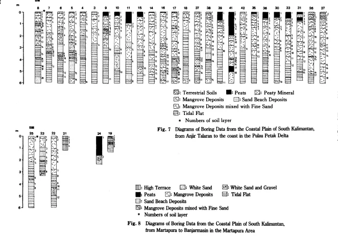
coast. Diagrams of boring data are presentedin Fig. 7 and 8.
Mineral riverine deposits zone. This zone
covers most of the area along the Negara and Barito rivers (see Fig. 5). Because extensive
study was concentrated in the Pulau Petak Delta and the Martapura areas, I did not carry
out boring here. But from field observations and from the air photo appearances, two
geomorphic units were found here. A narrow strip of (1) natural levees is slightly elevated
セ
ttl
w <J\D
•
セ'..J
Lセ
'..J
セ
セ
27
26 31 33 30 38 35 42 41
セZ White Sand and Gravel
§: TidalFlat
39 38
セ
18 17
16
セZZ Terrestrial Soils . :Peats セZ Peaty Mineral
ESJ:
Mangrove Deposits []: Sand Beach DepositsISJ:
Mangrove Deposits mixed with Fine Sand§: Tidal Flat
* Numbers of soil layer
Fig.7 Diagrams of Boring Data from the Coastal Plain of South Kalimantan, from Anjir Talaran to the coast in the Pulau Petak Delta
14
15
llIIJ:
HighTerraceEm:
White Sand • Peats E;J: Mangrove Deposits []: Sand Beach DepositsセZ Mangrove Deposits mixed with Fine Sand
*
Numbers of soil layerFig. 8 Diagrams of Boring Data from the Coastal Plain of South Kalimantan,
11 10 9 3 4 5 6
7
8
8M
2
4'
5 3
6 o m
m
25 23 22 21 24 19
0,
セ
..
セN セGiA1'1'
:::::セ'.'."セ
...,.. 6
'._'
21
セセセMセ
:..セ 5 .... ; - 6Zセイ
.... ""-. ' /'::: :::: \ ..
3
4
5
6
[image:20.842.90.752.66.530.2]Where the poorly developed levees have been breached by flood waters, (2) meandering scars
have formed. The sediments in the natural levees andinthe meandering scars are
catego-rized as riverine deposits.
Riverine to brackish deposits zone. This zone
is mostly covered by thin peat deposits
over-lying mangrove deposits and sand or gravel.
These deposits were found intwo places, (i)in the Pulau Petak. Delta area, covering mangrove
deposits; and (ii ) inthe Martapura area near to
Gambut village, covering sand and gravel. Lo-cal inhabitants use this region for rice and
coconut plantation.
The following four geomorphic units were
established. Mangrove deposits in the Pulau
Petak Delta, formed during the period of marine
transgression, were overlain by peat after emergence from the sea, resulting in (3) peat-capped mangrove deposits. The peats are
char-acterized by wood blocks and fibric material. Inthe area near to Gambut village, (4) peat-capped sand and gravel were found. The peats
are mostly derived from grasses with very few wood blocks.
(5) Natural levees continue until Sei Tabuk
village, where sediments contain admixtures of shell and sand. These are (6) former beach
ridges.
Typical profile descriptions· are as follows:
I. Profile BM-41, 9.85km50oNorth ofAnjir Sarapat along Hamill
*
Ubak.1. 0- 15 em Dark reddish brown (5YR 3/2)
hemic to sapric peats; abundant plant remains; pH 4.O.
2. 15- 25 em Grayish brown (5YR 4/2) hemic peat; few mineral materials; pH 4.0.
*
Handil is a local term ofcanal.3. 25- SO em Dark reddish brown (5YR 3/2) hemic peat; abundant plant re-mains; pH 4.O.
4. SO-1OO em Dark reddish brown (5YR 3/3) fibric peat; abundant plant re-mains; very soft; pH 4.0.
5. 100-107 em Dark reddish brown (5YR 3/4) fibric peat
6. 107-128 em Dark reddish brown (2.5YR 3/2-3/3) fibric peat; abundant plant remains; pH 4.O.
7. 128-178 em Dark reddish brown (5YR 3/2) fibric peat, abundant plant re-mains; few, wood blocks; pH 4.0. 8. 178-194 em Brownish black (5YR 2/1) peaty soil; abundant plant remains; pH 4.0.
9. 194-223 em Yellowish gray (2.5Y 5/1) clay; abundant organic matter; pH 4.0, pH oxidation 2.0.
10. 223-240 em LiC and wood blocks.
11. 240-280 em Gray (5Y 5/1) fine clay; moderate organic matters, plant remains;
massive, soft; pH 4.0, pH oxida-tion 1.0.
12. 280-331 em Gray (5Y 4/1) fine clay; few plant remains; massive, soft; pH 4.0, pH oxidation 1.0.
13. 331-387 em Gray (7.5Y 4/1
+
lOY 6/1) fine clay; few plant remains, massive; pH 4.0, pH oxidation 1.0.14. 387-400 em Dark olive gray and light yellow (5GY 4/1
+
2.5Y 7/3) silty clay;few organic matter; massive; pH 4.0, pH oxidation 1.0.
15. 400-426 em Yellowish gray (2.5Y 5/1) fine clay; few plant remains; massive soft; pH 4.0, pH oxidation 1.O.
16. 426-453 em Olive gray (5GY 5/1) fine clay; few plant remains; massive; pH 4.0, pH oxidation 1.0.
few mineral materials; pH 4.0, pH oxidation 1. O.
18. 500-600 ern Gray (lOY 4/1) fine clay; massive rather compact; pH 4.0, pH oxida-tion 1.0.
In this profile, the layers down to the depth
of 194 em are peat deposits. Down to the depth of 50 cm, the peat deposits are more decomposed, resultinginhemic to sapric peats
due to the extensive use this land for rice cultivation. At the depth of 50 to 194 em, all
peat layers are characterized by fibric material
and are very soft, due to their high water content.
At the depth of 194 to 600 cm, alllayers are
mangrove deposits of clay to fine clay in tex-ture. The presence of yellowish gray and olive-gray to light yellow soils indicates that pyrites
occurinthese deposits, aswillbe discussedina separate paper.
II. Profile BM-24, around Gambut village.
1. 0- 85 ern Dark reddish brown (2.5YR 3/3-3/2) fibric to hemic peats; abun-dant plant remains.
2. 85-160 ern Dark reddish brown (2.5YR 3/3) fibric peat; abundant plant re-mains.
3. 160-215 ern Coarse sand with small amount of gravel; very loose.
Based on the results of field observation, these peat deposits are mostly derived from
grasses. The organic matter deposited here is mainly characterized by species of recognizable
botanical origin and is of low bulk density, as willbe discussed in a separate paper.
The coarse sand and gravel can be catego-rized as low terrace.
Brackish
to marine deposits zone.
This zonecovers relatively flat areas of land with
eleva-tions of up to several meters. Until recently, these areas were covered by mangrove
vegeta-tion. Today, this vegetation grows well only near the coastline. The area behind the present
mangrove vegetation has been used by local people for rice and coconut plantation.
The geomorphic units of this region consist of (7) mangrove deposits on tidal flat, (8) former
thick sand ridges and (9) mangrove belt covering the present coastline.
A typical profile description is as follows (Profile BM-8, near to Sakata village) :
1. 0- 8 ern Brownish gray (7. 5YR 4/1) clay; abundant organic matter, plant remains; massive, rather soft. 2. 8- 29 ern Grayish brown (7.5YR 6/2) heavy
clay; moderate bright brown
(7.5YR 5/6) iron mottles; mod-erate plant remains in standing position.
3. 29- 58 ern Grayish brown (7.5YR 5/2) heavy clay; moderate bright brown (7.5YR 5/6) iron mottles; few plant remains.
4. 58- 82 ern Brownish gray and yellowish gray (lOYR 6/1
+
2.5Y 5/1) heavy clay; few, bright brown (7.5YR 5/6) iron mottles; moderate organic matter, plant remains; massive soft. 5. 82- 95 ern Gray (5Y 4/1) fine clay; few woodblocks; massive, soft.
6. 95-100 em Grayish yellow brown (lOYR 4/2) fine clay; abundant organic matter, plant remains in standing position; massive, soft.
7. 100-112 em Gray (7.5Y 4/1) clay; moderate plant remainsin standing position; little organic matter; massive, soft.
black (lOYR 2/1); few plant
re-mains in standing position;
mas-sive, very soft.
9. 116-148 cm Brownish gray (7.5YR 5/1) clay;
few plant remains in standing
posi-tion; massive, soft.
10. 148-163 cm Yellowish gray (2.5Y 5/1) clay
alternating with fine sand;
moder-ate plant remains; few sea-shells;
massive, soft.
11. 163-200 cm Yellowish gray (2.5Y 5/1) sand
alternating with thin layers of fine
clay; few sea-shells; massive,
soft.
12. 200-239 em Gray (5Y 5/1) sand alternating with
thin layers of fine clay; plant
remains; abundant sea-shells;
massive, soft.
13. 239-281 em Gray (lOY 5/1) sand alternating
withthin layers of fine clay;
mod-erate plant remains in horizontal
position, sea-shells; massive, soft.
14. 281-337 em Dark greenish gray (7.5GY
4/1-3/1) sand alternating with thin
layers of clay; moderate plant
re-mains, organic matter; sea-shells;
massive, very soft.
15. 337-384 em Yellowish gray (2.5Y 6/1) fine clay
alternating with fine sand; few thin
organic layers; massive, soft.
16. 384-400 cm Yellowish gray and dark greenish
gray (2.5Y 5/1
+
7.5GY 4/1) clay alternating with thin organic matterlayers; massive, soft.
17. 400-448 em Gray (lOY 5/1) fine clay alternating
with olive gray (2.5GY 5/1) sand
and thin organic matter layers; few
plant remains in standing position;
massive, soft.
18. 448-464 em Gray (lOY 5/1) fine clay alternating
with yellowish brown (2.5Y 5/3)
coarse sand and thin organic
mat-ter layers; few plant remains in
standing position; massive.
19. 464-545 em Gray (lOY 5/1) clay alternating
with greenish gray (7.5GY 5/1)
sand and thin organic matter layers; few plant remains in
stalld-ing position; massive.
20. 545-600 em Sand beach deposits; abundant
sea-shells; few organic matters.
In this profile, the layers down to the depth of 148 em are mangrove deposits. These de-posits contained bright brown iron mottles at
the depth of 8 to 82 cm, indicating the presence of pyrites accompanying with the plant remains
derived from mangrove vegetation.
All layers at the depth of 148 to 545 cm are
tidal flat deposits. Sometimes, thin organic layers were found here alternating with fine
clay.
Sand beach deposits were found at the depth
of 545 to 600 cm with abundant sea-shells. A sand beach was probably formed here during the past transgression period.
Flooded zone. Because this region is always
covered by floodwater, I had difficulty in
observing the soil in detail. From the area near the levees, however, I saw that the mineral deposits here are probably categorized as low
terrace. This terrace is constantly influenced by flooding, so the soil surface has turned light
gray. This is different from the terrace situated in the upper part of this region, which is mostly
chracterized by yellowish brown soils. Thus,
the soil surface of the low terrace in the flooded zone is probably covered by terrestrial soils
which have been transformed into fluviatile swampy soils.
During the field study, I found two
rivers, (10) natural levees have developed. During the rainy season, floodwater from these rivers enters this region, and because the levees dam up this water, (11) a perennially flooded area is fonned.
Geomorphic
History
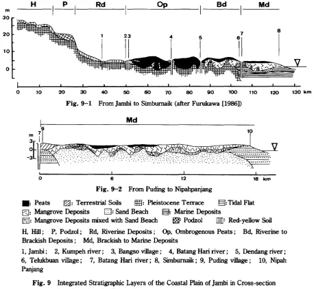
Fig. 9 and 10 show the integrated strati-graphic layers of coastal plains in Jambi and South Kalimantan, respectively, in cross-sec-tion from inland to the coast. These figures
indicate that the stratigraphic evolution of the two study areas is different. For instance, deep peat deposits were found in the coastal plains of Jambi, but not in South Kalimantan.
In
con-trast, Fig. 5 shows that the coastal plains of South Kalimantan contain an extensive flooded zone, while this is not the case in Jambi.Landfonn development in the coastal plains of Jambi and South Kalimantan has been influenced by the vegetation there and by the transgres-sion and regrestransgres-sion cycle in the past. When the
m
30
o
__H_ _
,_P_1__
R_d O---=-P B_d M_d_o 10 20 30 40 50 60 70 80 90 100 110 120 130 km
[image:24.595.72.531.308.729.2]o
Fig. 9-1 From Jambi to Sirnburnaik (after Furukawa[1986])
18 km
Fig.9-2 From PudingtoNipahpanjang
. : Peats セZ Terrestrial Soils セZ Pleistocene Terrace §:Tidal Flat
ESl:
Mangrove Deposits [J:Sand Beach §: Marine DepositsセZ Mangrove Deposits mixedwithSand Beach セZ Podzol
am:
Red-yellowSoilH, Hill; P, Podzol; Rd, Riverine Deposits; Op, Ombrogenous Peats; Bd, Riverine to Brackish Deposits; Md, Brackish to Marine Deposits
1, Jambi; 2, Kumpeh river; 3, Bangso village; 4, Batang Hari river; 5, Dendang river; 6, Telukbuan village; 7, Batang Hari river; 8, Sirnburnaik; 9, Puding village; 10, Nipah Panjang
Bd Md
o
2
10
3
! ! ,
[image:25.596.86.500.104.556.2]20 30 40
Fig. 10-1 From Antaraya to the coast
50 km
m 6
I
H
Rd
Bd20
10
-o
o 5 10 15 20 25 30 35 40 45 km
Fig. 10-2 From Martapura to Banjannasin
. : Peats セZ Terrestrial Soils
m:
Pleistocene Terrace §:Tidal Flat tg: Mangrove Deposits[J: Sand Beach [?SJ: Mangrove Deposits mixed with Sand Beach [J: White Sand or Gravel IEZ]: Clay mixed with White Sand \III]: Red-yellow Soil
H, Hill; Rd, Riverine Deposits; Bd, Riverine to Brackish Deposits; Md, Brackish to Marine Deposits 1, Barito river; 2, Anjir Talaran; 3, Anjir Sarapat; 4, Anjir Tamban; 5, Sakata Barn village; 6, Martapura; 7, Pembataan; 8, Sei Tabuk village; 9, Banjarmasin; 10, Barito river
Fig. 10 Integrated Stratigraphic Layers of the Coastal Plain of South Kalimantan in Cross-section from Inland to the Coast
sea level rose, big estuaries choked the free
discharge of rivers, so the coastal plains were submerged during the transgression.
Man-grove deposits were formed in the lagoons. After the final regression, the coastline
ad-vanced to expose alluvial deposits. Mangrove
vegetation settled on these deposits and ex-panded mangrove deposits towards the sea. In
Thus, the mangrove deposits in the coastal plains of Jambi and South Kalimantan appear to
consist of old and young deposits. The old deposits are related to the deposition processes during the transgression and regression of the
sea and are characterized by a heavy clay texture and dull yellowish brown to grayish
yellow-brown color. This is supported by the
fact that in the brackish to marine deposit zone
of the coastal plain of Jambi, in the area between Puding and Nipahpanjang villages, the
old mangrove deposits lie on the marine sand
(Fig. 9-2) and were formed while the sea level was stationary. Around Telukbuan village (see
Fig. 9- 1), this marine sand was also found
underlying the old mangrove deposits. The top of this marine sand formation is related to an
ancient sea level at least 3.0 m above the present level. The old mangrove deposits,
represented by charcoal sample of GaK-11897 (Table 5), started to accumulate approximately
5,900 years ago, which indicates that their
accumulation rate was about 0.6 mm/yr. Until recently, the old mangrove deposits were
cov-Table 5 The Results of 14C-Dating of Peat Soil Samples
Sample
No. (Av.Depthinem)
Age (Years BP)
Depth of Soil Calculated Rate of Peat Sample Accumulation
(cm)* (cm/l00yr)
Materialand Location
I.Jambi
OR-44 0- 40
OR-45 40-110
GaK-11897** 110-363
OR-46 0- 40
II. South Kalimantan
OR-39 0- 50
OR-40 50-172
Brackishto Marine Deposits Zone
220 ± 40 30- 50 18
Riverineto Brackish Deposits Zone
1120 ± 55 30- 50 4
Riverineto Brackish Deposits Zone
1420 ± 70 25- 75 4
Peat; SK- 19 Rantaurasau near to the FeederCanal Woody Peat; 7 kIn North-east of Pulaumentaro Charred wood; 7kIn North-east of Pulaumentaro Charred wood; 7kIn North-east of Pulaumentaro Woody Peat; 3kIn North of Rantaupanjang
Woody Peat; 3kIn North of Rantaupanjang
Peat; 5 kIn Northeast of Center of Anjir Sarapat Peat; 5 kIn Northeast of Center of Anjir Sarapat Woody Peat; SK- 8 Unit
n
DendangIWoody Peat; SK-8 Unit
n
DendangICharcoal; SK-8 UnitII Den-dangI 6*** 21 22 150-194 335-390 100-120 2000± 50 5980±180
Ombrogenous Peats Zone
4040±180 200-250 6
4360± 130 400-450 63
5710±130 700-750 22
5890± 190 200-250 4
6830± 180 400-430 21
1440± 55 0-225 425-725 0-225 225-425 225-425 GaK-11896** GaK-11894** GaK-11892** GaK-11893** GaK-11895**
* See Fig. 11
** Mer Supiandi and Furukawa [1986]
[image:26.597.74.533.321.727.2]GaK-l1S96
T T BO 8M
OR -44 OR-46
OR-39 OR -45
OR - 40 GaK-11894 GaK-1189Z
GaK-11897 ... GaK-11895 GaK -11 S93
B
5
7 4 2
3
8
6
m
o
. : Peats Q: Mangrove Deposits Em: Pleistocene Terrace
セZ Peaty Mineral 0:Terrestrial Soils
[image:27.599.55.515.112.346.2]B, T, and BD are profiles taken from the Kumpeh, Tanjung and Berbak Delta areas of Jambi, respectively; and BM is from the Pulau Petak Delta area of South Kalimantan.
Fig. 11 Depth ofSoilSamples Submitted to 14C-Dating
ered by dense forest. The young mangrove deposits, on the other hand, are related to the
present mangrove vegetation that now covers
them, and are characterized by clayey texture, gray to greenish gray color, and softness.
The inland area was submerged seasonally by freshwater which was dammed up by natural
levees. This retarded the decomposition of organic matter, and peat formation took place.
These peat deposits started to accumulate during the Holocene period (Table 5).
In
J
ambi, two peat deposits were found, (i) deep peats deposited on Pleistocene terrace, and (ii ) thin peats deposited on mangrovedeposits. Peats covering the Pleistocene
ter-race started to accumulate approximately 5,700 years ago in the Kumpeh area, and
approx-imately 6,800 years ago in the Tanjung area. During the first stage of peat accumulation on
the terrace, organic matter were derived from grasses and ferns. After the vegetation
changed to swamp forest, the organic matter
production increased drastically and a thick peat
dome was formed. In the center part of peat
dome, the elevation was increased by peat development to about 7.0 m above MSL.
Later peat formations are also found. Peat on mangrove deposits near Telukbuan started to accumulate approximately 1,400 years ago.
These peats are mostly less than 2.0 m thick and are derived from mangrove vegetation in
the upper layers and grasses and ferns in the bottom layers.
In the brackish to marine deposit zone, thin peats on mangrove deposits started to
accumu-late approximately 200 years ago, and are
mixed with mineral materials resulting in the peaty soils.
In South Kalimantan also, two peat deposits were found; (i) peats deposited on sand and
gravel are related to a low terrace fonnation.
Although I have no data about the age of the peats covering the sand and gravel, I believe that they probably developed during
transgres-sion period. When the sea level rose, the low terrace of sand and gravel would have started
to be inundated, and peats would have accumu-lated. The floral composition of peats deposited
here mostly derived from grasses in all layers. The thickness of peat deposits is not morethan
1.6 m (see Fig. 8, BM-24).
Peats on mangrove deposits in the riverine to
brackish deposit zone started to accumulate
approximately 2,000 years ago. These peats probably started to accumulate later than those
deposited on the sand and gravel.
The results of this investigation show that
the sediments in the coastal plains of Jambi consist of (i) Pleistocene terrace underlying
the thick peat-dome in the ombrogenous peats zone and mangrove deposits in the riverine to
brackish deposits zone; and (ii) mangrove
deposits underlying thinpeats in the riverine to
brackish deposits zone and overlying the tidal fiats in the brackish to marine deposits zone. In the coastal plains of South Kalimantan, the
sediments consist of (i) mangrove deposits underlying the peats in the riverine to brackish
deposits zone and overlying the tidal fiats in the brackish to marine deposits zone; and (ii) sand
and gravel underlying the peats in the riverine
to brackish deposits zone. In t:4e riverine· de-posits zone, the sediments in both coastal plains
are mostly fluviatile deposits. This clearly indi-cates that peat deposits in the coastal plains play an important role in the rise of topography,
while mineral soil deposits are significant in the accretion of coastline and the fonnation of
natural levees.
The rapid change of the coastline in Jambi and
South Kalimantan was caused by sediment
supply of riverine and marine origin, and by transgression and regression of the sea in the
past.
Acknowledgments
I would like to express my deep gratitude to Prof. Y. Takaya and Dr. H. Furukawa of the Center for Southeast Asian Studies, Kyoto University who gave me extensive guidance in all phases of this research. I wish to thank Prof. O. Koswara of the Faculty of Agriculture, Bogor Agricultural University for his help during the preparation of the field study. This re-search was facilitated by a grant from the Center for Southeast Asian Studies, Kyoto University, Japan and the Team of P3S-IPB, Bogor Agricultural University, Indonesia.
References
Andriesse,
J.
P. 1974. Tropical lowland peats in South-East Asia. Communication 63. Amster-dam : Department of Agriculture Research, Royal Tropical Institute.Brown, C. A. 1960. Palynological Techniques. Lib-rary of Congress Catalog Card Number 60-14297. Baton Rouge, La.
Furukawa, H. 1986. Shizen Chiri to Syokusei-Sunda lki no Dojo, Seitai Menba [Natural Geography and Vegetation - Soil and Ecological Members in Sunda Land]. Gaku Jutsu Geppoh fJapanese Scientific Monthly] 30(10): 724-729.
Furukawa, H.; and Supiandi, S. 1985. Batan Hari
Gawa Ryuiki Teishicchi no Nogyo Keikan. Sono
1. Chikei to Taisekisojo [Agricultural Landscape in the Lower Batang Hari, Sumatra. Part one: Stratigraphy and g・ッセッイーィッャッァケ of Coastal Swampy Lands]."Tonan AjiaKenkyu[Southeast Asian Studies] 23(1): 3-37.
Insti-tut Pertanian Bogor [Bogor Agricultural Uni-versity].
Kaila, A. 1956. Determination of the Degree of Humification in Peat Samples. Journal of the
Scientific Agricultural Society of Finland28: 18-35.
Supiandi, S.; and Furukawa, H. 1986. A study of
Floral Composition of Peat Soil in the Lower Batang Hari River Basin of Jambi, Sumatra. Tonan Ajia Kenkyu [Southeast Asian Studies] 24(2): 113-132.
Van Benunelen, R. W. 1949. The Geology of