69
Investigation of Shallow Structures as The Pathway of Oil Seep in The Alue
Punoe Village, Bireuen District, Aceh Province, Indonesia
Asrillah
1, Muhammad Syukri
1,2*, Marwan
1,2, Fuad Akbar
11Department of Geophysics Engineering, Engineering Faculty, Syiah Kuala University, Banda Aceh, Indonesia; 2Department of Physics, Mathematics and Natural Sciences Faculty, Syiah Kuala University, Banda Aceh, Indonesia.
Corresponding author, email: [email protected].
Received : 1 July 2016 Accepted : 20 July 2016 Online : 30 August 2016
Abstract - Measurement of magnetic data has been done in the area of oil seeps in the village of the Alue Punoe, with 121 measurement points as a grid within 500 m x 500 m area where each grid is approximately in 250 m2. The total magnetic field measurement has been examined by using Proton Precession Magnetometer (PPM). Upward continuation correction was applied to obtain residual magnetic field anomaly. Residual magnetic field anomaly data are mapped using the Surfer software, while subsurface models are made using the Mag2DC software. Based on the models that have been sliced from the local magnetic anomalies along the cross section of A-B and C-D from which then obtained a shallow structure which is a fault whose an approximate depth from 30 to 100 meters and three stratified media. The stratified media of the study area are interpreted as an alluvial deposit, alternating sandstone and clay and igneous rocks. Interpretation of subsurface models shows that there exists a shallow structure assumed as a fault. Expected fault has an adjacent to the manifestations which are about 50 to 70 m. It strengthens the case that the fault is strongly related to as the pathways of oil seeps from possibly existed petroleum system below subsurface of unknown strata.
Keywords:Magnetic method; Total magnetic field; Susceptibility; Fault
Introduction
Indonesia is the well-known country whose the natural resources than can be used for human welfare, especially oil and gas. The demand for oil and gas energy recently still increases that causes an unbalanced condition between demand and production. This condition is mainly due to by some technical disturbances and unplanned shutdown of several fields of oil and gas and also primarily influenced by the old fields that have run since 1971, so that the activity of hydrocarbon, as crude oil, exploration should be done to fulfill the domestic needs (Karno, 2012).
The crude oil is a complexly mixed hydrocarbon by having four until twenty-six or more carbon atoms. Generally, it consists of 80-85 % hydrogen elements, while the other elements such as oxygen, nitrogen, and sulfur are composed in the range 1-5 %. These elements of hydrocarbon are found as a surface oil seep in several places in Indonesia. The oil seep is simply not an economic value to be exploited, but it will become the strongly important hints for the planning of hydrocarbon exploration (Koesoemadinata, 1980), such as its existence in the Alue Punoe village in Bireuen District of Aceh Province.
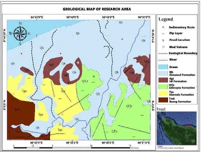
According to Keats et al. (1981) geologically the research area is commonly dominated by sedimentary rocks formation aging from old to young formation consisting of several formations i.e. Baong Formation (Tmb) containing calcareous clay, sublittoral sandstone in Pliocene age, Seureula Formation (Tps) composing of clastic volcano sandstone and calcareous mudstone of Pliocene age, Jalurayeu Formation (QTjr) in Plio-Pleistocene age having tuffaceous sandstone, clay, mudstone alluvial fan, Idi Formation (Qpi) pertaining to slightly compacted gravel, sand, shale and clay, while Unnamed Formation (Qh) in Holocene age consisting of coastal sediment and fluvial deposit. Geological structure in this area is highly complex because of the existing of dip layered folding structure. This information was derived from the geological map of the research area as drawn in Figure 1.
Aceh International Journal of Science and Technology
ISSN: 2088-9860
70
Figure 1. The simplified geological map of the research area (Modified from Keats et al., 1981)
Administratively, the Alue Punoe village is included in Peusangan Subdistrict and one part of its area exists of some oil seeps that are expected coming from the two old wells which are drilled by the Dutchman during Netherland colonialism in Aceh. These oil seeps have been possibly come out through the shallow structures such as micro-fractures and fissures. To make sure this phenomenon it was strongly recommended to do the research for unveiling the locally shallow subsurface structures by applying an appropriately geophysical method.
One of the geophysical methods that can be used to reveal the subsurface of geological structures is the magnetics method. The basic principle of magnetic method usage is to measure the magnetics field variation caused by the existed magnetics field anomaly from the subsurface of the earth. This method is usually used for identification and determining a location of rock mass within the earth which has a relatively high susceptibility, such as basalts and gabbro, while granite, granodiorite, and rhyolite have a moderate susceptibility value (Lita, 2012).
Like another geophysical method, this magnetics method is also using the apparatus to do the measurement at a field. The equipment used in this method is named Magnetometer. The Magnetometer records a relatively different magnetization of various rocks toward earth magnetic field. Rock mass is composed of the abundant magnetic mineral, for example, igneous rocks are rarely contained hydrocarbon, and while the sedimentary rocks have the relatively low susceptibility are highly more possible composed of hydrocarbon (Lita, 2012).
The aim of a magnetic survey is to investigate subsurface geology on the basis of anomalies in the
71
surface expressions of crustal and lithospheric processes. They can be pathways for the movement of fluids, especially water but have also been shown to act as barriers to fluid flow (Weber et al., 2012). The association between hydrocarbon seepage and the formation of authigenic magnetic minerals in the near-surface has important applications in hydrocarbon exploration. Application of this methodology can quickly identify the areas or prospects with the greatest petroleum potential. Although the discovery of shallow sedimentary magnetic anomalies does not guarantee the discovery of commercial hydrocarbon accumulations, it does identify areas requiring more detailed evaluation, thereby focusing attention and resources on a relatively small number of high-potential sites (Schumacher and Foote, 2014).
In the magnetic technique, the remarkable equation that correlates the relationship between a magnetic field and magnetized rocks is formulated (Telford et al., 1976),as summarized in equation (1).
B = µ H + M ………. (1)
Where B, the magnetic induction is the total flux of magnetic field lines through a cross-sectional area of a material, μo is the permeability of free space 4 x −7 Wb/Am− , H is the magnetic field applied to the material and M is magnetization or response of the materials to the applied magnetic field. Magnetic susceptibility (k) is another important parameter, the relationship between magnetic induction B, magnetizing force H and susceptibility k (Reynolds, 1997) is given as in equation 2.
B = µ H + k ...……… (2)
Where B is in tesla and k is dimensionless in SI units
Based on the introduction view elaborated above, this research is aimed to get information about the originated oil seep in the Alue Punoe area whose some manifestations. These evident drove this research to find the locally shallow structures predicted as the pathways of oil seeps rising onto the surface.
Materials and Methods
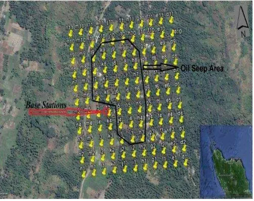
The research has been carried out from March to June 2016 at the Alue Punoe village in Subdistrict Peusangan of Bireuen District, Aceh Province-Indonesia. The equipment used in this research consist of one set of measurement tools of GEM System Proton Precision Magnetometers (PPM), while especially for the PPM is only used 2 units. The data was acquired by measuring magnetic intensity value at every point designed to form a grid shape and named by the notations, i.e from d1 and d11 to n1 and n11, as laid
out in Figure 2, then its distance to the others is an approximately 50 m x 50 m. The total number of points utilized to probe data are 121 points. These points were selected to cover the assumed shallow structure of oil seep channels within the vicinity marked by the black line. The One PPM was placed at selected point as the Base Station controlling the daily magnetics intensity variation during measurement, while the another is used for walk away recording.
The first recording of the magnetic intensity starts from d1, d2 until n10, n11 by
following the zigzag pattern. Both of the walk away PPM and Base Station PPM must be avoided from the metal objects during measurement that interferences the magnetic intensity (Hinze, 2013). The physical property measured is magnetic induction B from subsurface rocks that are then derived corrections, the data were then filtered by using the Surfer to run the low and high pass filter intending to enhance reasoning of magnetics field anomaly. The followed software used is the Mag2DC by which the subsurface magnetics anomaly can be modeled to provide a way of the quantitative interpretation.
72
Results and Discussion
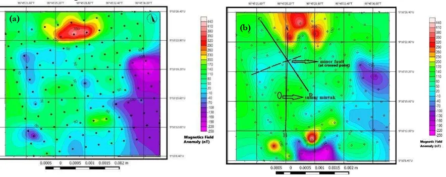
According to data processing, the result of this research was obtained that the magnetic field anomaly is in the range of 440 until -250 nT that includes both of the regional and local anomalies. The contour map of detailed magnetics anomaly is shown in Figure 3a. From regional and local anomaly (Figure 3a), it can not directly be interpreted because the magnetic study commonly focuses on the local area and structures related to oil seep manifestation. It must be alleviated the regional anomaly to obtain the local or residual anomaly representing the intended structure below subsurface of the oil seep. Based on that reasoning, the magnetic anomaly depicted above must be filtered to omit the regional anomaly. The kind of filtering that was applied is the downward continuation that suitable toward the topography of the research area. After applying the 10-15 meters continuation, so it was obtained the residual magnetic anomaly which is then very useful for qualitative interpretation. The residual or local magnetics anomaly as can be seen in Figure 3b.
Figure 3. The magnetics field anomaly of the study area (a) regional and local anomaly (b) local anomaly
According to Figure 3b, it can be derived information that there is an existed residual or local magnetic anomaly around the point whose the coordinate 96045'25.20"E and 5020'80"N where the
coordinate is exactly at the intersection between the lines of A-B and C-D. Around the intersected point the susceptibility value is in the range from 30 nT to -90 nT. This anomaly is qualitatively expected as a minor fault referred to susceptibility values published by (Telford et al., 1976). The minor fault is closed to the manifestation as an oil seep whose approximately 50-70 meters long. This fact is strongly related to becoming a good match result.
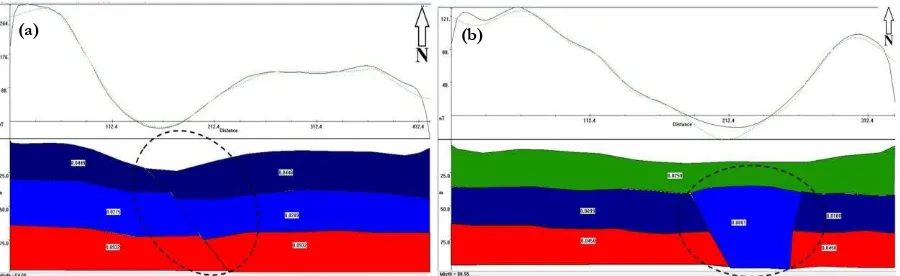
To get information that can be interpreted quantitatively, the anomaly obtained from Figure 3a must be derived to construct models by slicing the two slices on the anomalies as drawn in Figure 3a (the lines of A-B and C-D). The models produced also were referred to the geology hypothesis about sedimentary fault from (Grauch and Hudson, 2007) that can be seen in Figure 4. After getting anomaly models with which the qualitative information of minor fault can be interpreted quantitatively. The two anomaly models resulted from Mag2DC calculation can be visualized as shown in Figure 5. From Figure 5 shows that the first anomaly model (A-B) is confirmed there is an existing minor fault as the shallow structure. The type of fault is more likely possible a normal fault whose a generally layered media. The average length of fault is approximately 80 meters long in a diagonal direction toward 2D section and its position locates horizontally between 170 and 220 meters. The three layered media consist of alluvial deposit (0.04 susceptibility value) starting from surface to 30 m depth, followed by an alternating bed between sandstone and clay (0.027 susceptibility value) that were stratified from 30 to 62 meters overlaid by the first layer and the last layer is 38 meters in thickness or 100 meters depth from the surface composing of igneous rocks (0.09 susceptibility value). All of the lithological types are referred to (Telford et al., 1976).
(a)
73
Figure 4. The geological hypothesis of stratigraphic model for sedimentary fault
Figure 5. The two magnetic anomaly model. (a). The A-B slice and (b) The C-D slice
While the second magnetic anomaly model is also existed the fault whose remarkably different shape compared to the first model, where its shape is likely trapezium and break through the two layered media. The fault laterally extends from 165-265 meters and has an averaged 75 meters in thickness. This type of fault is considered as an intrusion rocks whose 0.0001 its susceptibility and predicted as sandstone (Schön, 2004). This second revealed model has almost similar their lithology and thickness of the first anomaly model. Furthermore, from both qualitative and quantitative interpretation above whose a match information can be inferred that the minor fault as a shallow structure is strongly estimated as the pathway of oil seep onto the surface. The continuous oil seep is certainly a fact that it is exactly originated from a source rocks that have not been yet unveiled which would have to become the continued study.
Conclusions
The Utilizing of the magnetic method in this study has succeeded to get subsurface information about the pathway of oil seep, where there is an existed fault originated from interpreted models (A-B and C-D) that have an orientation to both NS and NW directions. Its depth lies approximately from 30 to 100 meters and generally magnetic anomalies also revealed that there are existed three layered media lithologyes consisting of alluvial deposit from the surface until 30 meters depth and followed by alternating strata between sandstone and clay whose depth from 30 to 62 meters and the last layer is a blended lithology between sandstone and igneous rocks stratified from 62 until 100 meters depth.
References
Grauch, V. J. S. and Hudson, M. R. 2007. Guides to understanding the aeromagnetic expression of faults in sedimentary basins: Lessons learned from the central Rio Grande rift, New Mexico. Geosphere, 6: 596-623.
Hinze, W. J., Frese, Von. R. R. B., Saad, A. H. 2013. Gravity and magnetic exploration principles: practices, and applications. Cambridge University Press, New York.
74
Hui, L., Qingjun, Z., Puyuan, T. and Wenguang, H. 2015. Technologies and applications of geophysical exploration in deep geothermal resources in China. Proceedings World Geothermal Congress. Melbourne, Australia.
Karno, W. 2012. Study of energy demand supply. Ministry of Energy and Mineral Resources, Republic of Indonesia, Jakarta.
Keats, W., Cameroon, N.R., Djunuddin, A., Ghazali, S.A., Harahap, H., Kartawa.W., Ngabito, H., N.M.S., Thompson, S.J. and Wahyono, R. 1981. Geological map of Lhokseumawe Sheet, Sumatra. The Research Center and Developmental Geology, Bandung.
Koesoemadinata. 1980. The geology of oil and gas. 2nd Edition, Vol. 2. Institut Teknologi Bandung Press, Bandung. Lita, F. 2012. Identification of magnetic anomaly in Bumi Arjuna’s Geothermal Prospect. University of Indonesia,
Jakarta.
Mariita, N.O. 2013. Strengths and weaknesses of gravity and magnetics as exploration tools for geothermal energy. Presented at Short Course VIII on Exploration for Geothermal Resources, organized by UNU-GTP, GDC, and KenGen, at Lake Bogoria and Lake Naivasha, Kenya.
Reynolds, J.M. 1997. An introduction to applied and environmental geophysics. John Wiley and Sons, England. Saad, R., Kiu, Y.C., Saidin., M.M. and Karamah, M.M.S. 2013. Identifying subsurface features using magnetic residual
in Bukit Bunuh, Perak, Malaysia. Electronic Journal of Geotechnical Engineering, 18: 1367-1374.
Schön, J.H. 2004. Physical Properties of Rocks: Fundamentals and Principles of Petrophysics. Institute of Applied Physics. Austria.
Schumacher, D. and Foote, R.S. 2014. Seepage-induced magnetic anomalies associated with oil and gas fields: onshore and offshore. Adapted from extended abstract prepared for oral presentation at AAPG International Conference and Exhibition, Istanbul, Turkey.
Telford, M.W., Geldart, L.P., Sheriff, R.E. and Keys, D.A. 1976. Applied geophysics. Cambridge University Press, New York,