See discussions, stats, and author profiles for this publication at: https://www.researchgate.net/publication/311525685
The Investigation of 137Cs Contamination in
Soils of Aceh after the Tsunami
Article · August 2016
DOI: 10.17146/aij.2016.518
CITATIONS
0
READS
5
2 authors, including:
Some of the authors of this publication are also working on these related projects:
Iodine-131 air monitoring of stack release from radioisotop production facility
View project
Gatot SuhariyonoBadan Tenaga Nuklir Nasional
23 PUBLICATIONS 4 CITATIONS
SEE PROFILE
The Investigation of
137
Cs Contamination in Soils
of Aceh after the Tsunami
Syarbaini
*and G. Suhariyono
Center for Radiation Safety Technology and Metrology, National Nuclear Energy Agency Jl. Lebak Bulus Raya No. 49, Jakarta 12440, Indonesia
A R T I C L E I N F O A B S T R A C T
Article history: Received 29 May 2015
Received in revisedform 02 November 2015
Accepted 25 November 2015
Keywords: Cs-137
Artificial radioactivity Soil
Tsunami Aceh
Cs-137 is one of the most common radionuclides used for analysing man-made radioactive contamination in the environment beside Sr-90. Nangro Aceh Darussalam Province suffered the greatest mortality, with widespread destruction extending along more than 1000 km of coastline on 26 December 2004 due to tsunami. The disaster were affected areas about 220 km long and around 5 km wide along the coastlines of Aceh and North Sumatra. The purpose of this study is to investigate the artificial radioactivity 137Cs in soil samples which have been collected from various locations along the areas affected by tsunami in Aceh. The surface soil samples were collected from 20 sites in this region. The soil samples from the middle area of Aceh which was not exposed to the tsunami have also been investigated for comparison. The activity concentration of 137Cs in the samples was measured using a ORTEC P-type coaxial high purity Germanium (HPGe) detector system. The artificial radioactivity level of 137Cs measured from these samples was found in the range of not detected to 2.09 Bq.kg-1 for the
affected soil samples and 0.56 to 1.44 Bq.kg-1 for unaffected soil respectively. The radioactivity concentrations of 137Cs within the coastline areas are comparable
to that of the middle area, which was not exposed to the tsunami. The results indicate that there are no new inputs of man-made radionuclides into the area at that time and the data obtained could serve as baseline levels of 137Cs in Aceh Region.
© 2016 Atom Indonesia. All rights reserved
INTRODUCTION
Man-made radionuclides in the environment are an important source of radiation exposure for
humans. 137Cs is a man-made radionuclide released
into the environmental ecosystems originating from nuclear weapon tests, nuclear facility accidents, radioactive waste dumping, and nuclear power plant leakage. The atmospheric nuclear test explosions in the Northern and Southern Hemisphere, with a distinct peak in 1962-1965, are the main source of global contamination by man-made radionuclides. Radioactive fallout from these test explosions contaminated globally on the surface of the Earth. 137
Cs is a radioactive isotope with a half-life of 30.2
years. Due to its long half-life, 137Cs diffuses and is
Corresponding author.
E-mail address: [email protected] DOI: http://dx.doi.org/10.17146/aij.2016.518
transported over the whole world by atmospheric circulation and falls to the ground in the form of dry depositions and wet depositiosn. Consequently, the
concentration of 137Cs fallout in environment has
become an indicator for analyzing man-made radioactive contamination in the environment and been widely used as a tracer of soil redistribution and has been proven useful in soil erosion studies performed around the world [1-4].
In the terrestrial environment, soil is the principal reservoir of artificial radionuclides and acts as a media of migration systems for these radionuclides, because soil accumulates artificial radionuclides originating from the nuclear weapons and nuclear accident [5-7]. In the marine environment, artificial radionuclides introduced to surface waters by wet and dry depositions does not stay in steady-stay conditions, because the ocean is a dynamic system due to currents and processes in
Atom Indonesia
Syarbaini and G. Suhariyono / Atom Indonesia Vol. 42 No. 2 (2016) 47 - 51
the water column
.
The artificial radionuclides aretransported to different regions, as well as to bottom waters and sediments [8,9]. tsunami that traveled rapidly throughout the Indian Ocean, striking beachfront areas in many countries with catastrophic results in Indonesia, Thailand, Sri Lanka, India and Bangladesh, as well as other Asian and East African countries. As a result of the earthquake and tsunami, approximately 110,000 people died, and many buildings and infrastructure collapsed. The ensuing tsunami swept debris and sea water into homes and buildings up to 5 kilometers inland, crushing them and further damaging roads, bridges, telecommunications systems, water and electricity systems, crops, irrigation, fishery infrastructure, and food and fuel outlets [11]. The resulting movement of sea water and sand may have redistributed radioactivity along the Aceh coast of the Sumatra Island. Therefore, it
is urgent to carry out an investigation on 137Cs
radionuclide in surface soil and its spatial distribution in this region to evaluate the influences of the Aceh tsunami disaster on Sunday morning, 26 December 2004.
Most previous studies on soil in tsunami-affected areas are limited to the physical and chemical properties of soils in Aceh [12-14] and did
not attempt to study 137Cs contamination. Several
studies focus on the impacts of tsunami on agriculture, including soil salinity, soil profiles, changes in soil properties over time, and crop response [15-17]. Measurements of
naturally-occurring radionuclides 226Ra, 232Th, and 40K in the
soil from tsunami affected area were carried out to evaluate the changes of the naturally-occurring radionuclide contents in surface soils associated with soil erosion and sedimentation [18].
Until now, the 137Cs measurement data in soil
of the environment in Aceh are not available.
The fission product 137Cs has similar chemical
characteristics to K, which causes it to move easily through the environment. Data and knowledge of
the distribution pattern of 137Cs radionuclide in this
region is essential in maintaining some sense of control of prevailing radiation levels to assess the radioactive environmental quality and to develop strategies for soil management and protection.
The measurement of radioactive contents of soil in this region is of interest not only for additional information to represent baseline data for
the nation but also for worldwide database and further studies in the region. The objective of this research was to determine the present activity
concentrations of 137Cs in soil from along the coastal
beaches of Aceh Region, and to provide the detailed baseline data and spatial distribution patterns in surface soil.
EXPERIMENTAL METHODS
Description of the study area
The study area is located in the northern part of the island of Sumatra, Indonesia. Aceh is one of a province in Indonesia officially named Nanggroe Aceh Darussalam. It is the western most province of the Indonesia with the Indian Ocean to the west, the
strait of Malacca to the east, located between 20-60
North latitudes and 950-980 East longitudes with the
area of approximately 57,365 km2, or 12.26% of Aceh Darussalam (NAD) province [11].
Sampling and sample preparation
Two types of soils were selected for the study those tsunami affected soil and unaffected soils. The tsunami affected soil samples were collected from various locations along the west, north and the
east coast of Aceh by random selection [19]. The unaffected soil samples (normal soil) were used
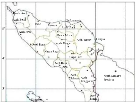
as the reference to compare with affected soil collected from various areas far away from the coast. Figure 2, shows the map of Nanggroe Aceh Darussalam (NAD) province and the location of the soil sampling sites. After collection, each soil sample was wrapped in black plastic bag and labelled according to the name of the location where
it is located. The geographical coordinates of the sampling point were recorded by using Global Positioning System, GPS Map 60CHx manufactured by Garmin.
Fig. 2. The map of the Province of Aceh and the location of the soil sampling sites.
In the laboratory, the soil samples were dried
in an oven at a temperature of 105oC to a constant
weight to remove any available moisture. After drying, the samples were ground with a grinder to pass through a 250 µm sieve. Afterwards, the homogenized samples were packed to fill one-liter marinelli beakers.
Activity determination
The 137Cs activity concentrations of the soil
samples were determined with the help of an ORTEC P-type coaxial high-purity germanium (HPGe) detector with a relative efficiency of 60% and a resolution of 1.95 keV (full width at half maximum) for the peak of 1,33 keV. The detector was coupled to a computer-based multichannel
analyzer. The gamma ray spectrum was
recorded using a personal computer-based
4096-channel analyzer and processed using ORTEC
GammaVision-32 gamma spectrum analysis
computer software. To reduce the external gamma-ray background in the measured spectrum, the detector was put inside a cylindrical lead shield of
10.1 cm thickness with an internal diameter of 28 cm and a height of 40 cm. The lead shield is
lined with several layers of tin and copper, each 0.5 and 1.6 mm thick respectively. The measurements were carried out in the counting room located in the basement of the laboratory building.
The energy and efficiency calibration of the system for the determination of radionuclides in the prepared samples was carried out using a certified standard source (mixed gamma) and International
Atomic Energy Agency (IAEA) reference materials prepared in geometrical shape and composition to
simulate the samples’ matrix. The measurement
time for samples and background was 17 hours. The background count was used to correct the net peak area of gamma rays of the measured isotopes. Since the absolute efficiency was employed in the same Marinelli beaker geometry and the same approximate density as the samples, the difference in the self-attenuation for gamma rays in the sources and samples was assumed to be negligible. Quality assurance was additionally guaranteed by regular
participations in national and international
intercomparison exercises [20].
The activity of 137Cs was determinedfrom its
gamma energy peak of 661 keV. The activity
concentrations (A) of 137Cs in Bq kg-1 for the
samples were determined using the following expression:
counting efficiency of the detector system at energy
E, Pγ = the gamma ray emission probability (gamma
yield) at energy E, tc = sample counting time, and
M = mass of sample (kg).
RESULTS AND DISCUSSION
The analysis results of soil sample collected from tsunami affected area are presented in Table 1.
Results indicate that the 137Cs activity concentration
in the surface soil of tsunami affected area ranged
from the ND (not detected) to 2.09 ± 0.32 Bq.kg-1.
As appears from Table 1, activity concentrations of 137
Cs in surface soil collected from tsunami affected area remarkably vary from location to location and
are not uniform. 137Cs in some soil samples was
found to be lower than the minimum detectable activity of the gamma counting systems (<MDA). This could be explained by the fact that the tsunami had destroyed the land along of coastline. Several changes in land and soil texture due to tsunami flow and the subsequent backflow could be attributable to
transfer and redistribution of 137Cs from one location
to another. Removal of topsoil through accelerated sea water erosion could be attributable to vary distribution. These suggest that there are runoffs and
soil redistribution effect on 137Cs in soil so that 137Cs
was transferred.
Unlike the analysis results of soil samples from tsunami-affected areas, all soil samples collected from unaffected areas showed that the 137
Cs activity concentrations varied within a
relatively narrow range. As can be seen in Table 2,
Syarbaini and G. Suhariyono / Atom Indonesia Vol. 42 No. 2 (2016) 47 - 51
the activity concentrations of 137Cs in the surface
soil ranged from the 0.56 ± 0.19 Bq kg-1 to
1.44 ± 0.25 Bq kg-1. This results indicate that 137Cs
in soil of areas unaffected by the tsunami was nearly uniformly distributed because this areas were not
affected by the tsunami disaster. The 137Cs in the
soil unaffected by the tsunami was believed to have originated from the global fallout of atmospheric
nuclear weapons tests and accident. The
atmospheric nuclear weapons tests were carried out worldwide mostly by the USA and the Soviet Union
with the most intense periods in 1961–1962.
After the Limited Test Ban Treaty came into effect in 1963, the debris from low-yield detonations
GPS Coordinates 137Cs Activity
Concentration
Table 2. The activity concentration of 137Cs in surface soil
samples of normal area.
Sample
Code Site
GPS Coordinates 137Cs Activity
Concentration
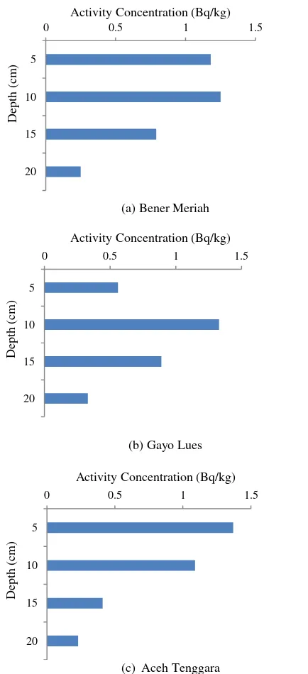
To confirm the assumption, a measurement of 137
Cs concentration was carried out in different depths of undisturbed soil collected from the tsunami unaffected areas (Bener Meriah, Gayo lues and Aceh Tenggara). Soil samples were collected by a corer 12 cm × 12 cm and 20 cm depth, segmented
in 0-5, 5-10, 10-15 and 15-20 cm layers.
The vertical distribution profile of 137Cs for the
tsunami unaffected area is showed in Fig. 3. As can be seen in Fig. 3, the activity concentration for each
layer of the locations were plotted against depth to
show the depth distribution of 137Cs in the soils.
The activity concentrations of 137Cs from this area
showed that the highest values found in the surface and second layer and the activity concentrations decreased gradually with depth, showing a penetration depth of approximately 20 cm from the surface. The result of this study is close to that from some locations in neighboring regions such as in Pahang, Sarawak and Serpong reported in previous
studies conducted by Hamzah, Z. et al. [21],
Takahisa, F. et al. [22] and Lubis, E. [23].
The depth profiles of 137Cs activity concentration in
the overall distribution patterns were observed and it seems to have the similar pattern.
(a) Bener Meriah
(b) Gayo Lues
(c) Aceh Tenggara
Fig. 3. Depth distribution of 137Cs activity concentration in soils of areas unaffected by the tsunami (a) Bener Meriah, (b) Gayo Lues and (c) Aceh Tenggara.
CONCLUSION contamination. The evaluation results of the activity
concentration of 137Cs show that the activity
concentrations of 137Cs in the surface soils are
remarkably dependent on the sampling location due to the tsunami disaster. In general, the range of the
activity concentrations of 137Cs in soil samples
collected from tsunami-affected areas is comparable with normal area (areas unaffected by the tsunami), which suggests that the radioactive environments in these areas were affected mainly by the fallout from past atmospheric nuclear explosion tests.
ACKNOWLEDGMENT
The authors acknowledge the National Nuclear Energy Acency for the financial support throughout this work. The authors also gratefully
acknowledge all staff members of the
Environmental Safety group for their technical assistance.
9. Anonymous, Radioactivity in the marine
environment 2011, Results from the
Norwegian National Monitoring Programme (RAME), StrålevernRapport 2015:3. Østerås: Norwegian Radiation Protection Authority, (2015).
10. N. Horspool, I.R. Pranantyo, J. Griffin et al.,
A national tsunami hazard assessment for
Indonesia, Australia–Indonesia Facility for
Disaster Risk Reduction, Australian
Government Department of Foreign Affairs and Trade, Canberra (2013).
11. Anonymous, Preliminary damage and loss
assessment the december 26, 2004 natural disaster, A Technical Report prepared by BAPPENAS and the International Donor Community, National Planning Development Agency (BAPPENAS), Jakarta (2005).
12. N.R. Hulugalle, R. Jaya, G.C. Luther et al.,
Catena 77 (2009) 224.
13. S.C. Liew, A. Gupta, P.P. Wong et al.,
Geomorphology 114 (2010) 520.
14. M. Rusdi, R. Roosli, M. Sanusi et al., Egypt.
Coastal Management 71 (2013) 176.
18. Syarbaini, E. Pudjadi, International Journal of
Applied Environmental Sci. 10 (2015) 487.
19. Anonymous, Soil Sampling for Environmental
Contaminants, IAEA-TECDOC-1415, IAEA,
Vienna (2004).
20. Syarbaini, Kusdiana and D. Iskandar,
International Journal of Sustainable Energy
and Environment 3 (2015) 1.
21. Z. Hamzah, C.Y. Amirudin and A. Saat,
Malaysian Journal of Fundamental & Applied
Sci. 8 (2012) 18.
22. F. Takahisa and R.J. Wasson, Journal of Asian
Earth Sci. 77 (2013) 108.
23. E. Lubis, Atom Indonesia 37 (2011) 57.
![Fig. 1. The areas affected by tsunami in the Nanggroe Aceh Aceh Darussalam (NAD) province [11]](https://thumb-ap.123doks.com/thumbv2/123dok/4032398.1975818/3.595.328.543.408.545/areas-affected-tsunami-nanggroe-aceh-aceh-darussalam-province.webp)