RADIOMETRIC BLOCK ADJUSMENT AND DIGITAL RADIOMETRIC MODEL
GENERATION
A. Prosa,∗, I. Colominaa
, J.A. Navarroa
, R. Antequerab
, and P. Andrinalb
a
Institute of Geomatics, Av. Carl Friedrich Gauss, 11 Parc Mediterrani de la Tecnologia, 08860 Castelldefels, Spain -(alba.pros, iael.colomina, jose.navarro)@ideg.es
b
Altais SL, Juan Alvarez Mendizabal, 76 Bajo C, 28008 Madrid, Spain -(r.antequera, p.andrinal)@altais-sl.com
Commission WG VI/4
KEY WORDS:Radiometry, photogrammetry, digital terrain model, radiometric terrain response, radiometric calibration, block ad-justment, atmospheric models, BRDF
ABSTRACT:
In this paper we present a radiometric block adjustment method that is related to geometric block adjustment and to the concept of a terrain Digital Radiometric Model (DRM) as a complement to the terrain digital elevation and surface models. A DRM, in our concept, is a function that for each ground point returns a reflectance value and a Bidirectional Reflectance Distribution Function (BRDF). In a similar way to the terrain geometric reconstruction procedure, given an image block of some terrain area, we split the DRM generation in two phases: radiometric block adjustment and DRM generation. In the paper we concentrate on the radiometric block adjustment step, but we also describe a preliminary DRM generator. In the block adjustment step, after a radiometric pre-calibraton step, local atmosphere radiative transfer parameters, and ground reflectances and BRDFs at the radiometric tie points are estimated. This radiometric block adjustment is based on atmospheric radiative transfer (ART) models, pre-selected BRDF models and radiometric ground control points. The proposed concept is implemented and applied in an experimental campaign, and the obtained results are presented. The DRM and orthophoto mosaics are generated showing no radiometric differences at the seam lines.
1 INTRODUCTION
In this paper we present a radiometric block adjustment method that is related to geometric block adjustment and to the concept of a terrain Digital Radiometric Model (DRM) as a complement to the terrain digital elevation and terrain models. A DRM is digital model that gives the reflectance value and the Bidirectional Reflectance Distribution Function (BRDF) of each ground point.
In the block adjustment step, the camera is radiometrically pre-calibrated, some local atmosphere radiative transfer parameters and the reflectance and BRDF are estimated at the radiometric tie points. This radiometric block adjustment is based on radia-tive transfer models, pre-selected BRDF models and radiometric ground control points.
The underlying concept is that if a Digital Terrain Model (DTM) and/or Digital Elevation Model (DEM) together with a DRM are available, not only the traditional cartographic representations of the terrain can be produced, but also realistic simulations of an area can be produced by freely setting parameters like the time (date and time within the day) and the atmospheric conditions.
The importance of radiometry in the digital airbone photogram-metry, in comparison to the analog systems is highlighted by (Honkavaara et al., 2009). Besides, (Honkavaara et al., 2009) point that improving the automation potential of photogrammet-ric applications is possible with a rigorous treatment of image radiometry.
The knowledge of the terrain radiometric response (DRM) also allows correcting all the images of the whole block eliminating the radiometric differences between them. The correction of the radiometry in aerial images is one of the main milestones in aerial photogrammetry in order to improve their applications such as otrhophoto mosaics or land-cover classification.
In the related literature different ideas to correct the radiometric heterogeneities are available.
A radiometric aerial triangulation is presented by (Chandelier and Martinoty, 2009), with analogy to the standard aerial tri-angulation to generate orthoimages without radiometric hetero-geneities. Instead of considering physically-based models, they propose another category of radiometric correction methods: em-pirical (statistical approach based on histogram equalization) or semi-empirical (taking into account only the most prominent ra-diometric effects (for examples BRDF or the atmospheric model proposed by (Richter and Schl¨apfer, 2002))) corrections. They provide a relative correction between images, using exclusively image-based information.
A polynomial radiometric block adjustment is proposed by (Falala et al., 2008). Similar to the approach presented by (Chandelier and Martinoty, 2009), (Falala et al., 2008) do not use a physical model.
(Olsen et al., 2010) suggest a method for the calibration of agri-cultural cameras (AgCam). A radiometric block adjustment is proposed for correcting the vignetting effect, the Charge-Coupled Device (CCD) non-uniform quantum efficiency and the Charge-Coupled Device (CCD) dark current, separately. At the end, by calibrating the AgCams and correcting all the images, they reduce the radiometric heterogeneities in the orthophoto mosaics.
In this paper we propose and test a radiometric block adjustment concept. In a way, it is similar to those previously reported by (Chandelier and Martinoty, 2009), (Richter and Schl¨apfer, 2002), (Falala et al., 2008) and (Olsen et al., 2010), but using physical-oriented models, like (Honkavaara et al., 2012a). However, the physical-oriented models used in the present paper are different than the one used by (Honkavaara et al., 2012a). In our con-cept, after a radiometric pre-calibration (vignetting effect) step we perform a self-calibrating radiometric block adjustment with radiometric calibration, BRDF and atmospheric radiative trans-fer (ART) models. In the adjustment, the observations are the image digital numbers (DN) and the ground control reflectances (ρ). The unknown parameters are the sensor calibration param-eters, the ground reflectances of the radiometric tie points and additional BRDF and ART parameters. From these parameters, both the DRM and the radiometrically corrected images can be derived. The orthophoto mosaics obtained with the corrected im-ages will then allow to at least verify the consistency of the radio-metric adjustment results.
In the following section the radiometric camera calibration mod-els, the atmospheric model and the BRDF model are described, as well as the method for the radiometric block adjustment. In section 3, we present the DRM generation concept. An exper-imental campaign to validate the proposed approach is detailed in section 4. Finally, some conclusions are presented as well as further research to be pursued.
2 RADIOMETRIC MODELS AND BLOCK
ADJUSTMENT
The radiometric calibration and block adjustment procedure is divided in two phases: pre-calibration and self-calibrating block adjustment. As mentioned, the model for the radiometric mea-surements (DNs) includes a radiometric self-calibration model, a BRDF model and an atmospheric radiative transfer (ART) one.
2.1 Radiometric pre-calibration
The pre-calibration model proposed in this paper aims at cor-recting the vignetting effect, which consists of the radial falloff of the intensity from the principal point of the image, as de-tailed by (Olsen et al., 2010), (Goldman, 2010) and (Zheng et al., 2009). The vignetting effect can be produced by different phys-ical causes: natural vignetting (due to geometric optics: angle at which the light exits from the rear of the lents), pixel vignetting (due to the angular sensitivity of digital optics), optical vignetting (due to the light path blocked inside the lens body by the lens di-aphragm, easily observed by the changing shape of the clear aper-ture of the lens, which reduces the amount of light reaching the image plane) and mechanical vignetting (due to certain light path becoming blocked by other camera elements). However, a single “elliptic” polynomial estimation model is sufficient to describe the phenomena. Given a reference calibration object surface with homogeneous constantdn0we have used the 6th degree polyno-mial
dn, the measurement, is the digital number of an image pixel andvnits residual. (x0, y0)is the principal point of symmetry (PPS) of the image. Besides,(∆x0,∆y0)model the vignetting
decentering with respect to the PPS andk1 andk2stand for the major and minor semi-axis of the “ellipse.”
We have found that a global calibration parameter subset∆x0, ∆y0,k1andk2 suffices while colour dependent subsetsv1,v2, v3are required for each colour channel.
2.2 Radiometric self-calibration
The self-calibration phase estimates the gain (α) and offset (β) of the camera, giving the relation between the at-sensor radiance (LS) and the digital number (dn) for each pixel:
dn=αLS+β. (3)
To a large extent, the values ofαandβare constant for all the images taken with the same sensor within some period of time. However, theses values are different for each colour channel.
2.3 Atmospheric radiative transfer model
In this work, the proposed atmospheric radiative transfer model is based on the Radiative Transfer Model (RTM) used by (Beisl et al., 2008). The RTM takes into account the solar irradiance, the diffuse radiation, the backscattered solar irradiance and the solar radiance reflected by the surroundings:
LS=L0+
ρ ρiS TdTu
π(1−sρρi) (4)
withL0standing for the upward radiance of the atmosphere for zero surface reflectance.
being the mean solar irradiance,a the Earth-Sun distance, r the mean Earth-Sun distance, andθi the Sun zenith angle. ρi is the reflectance of one single point in the terrain andρcorresponds to its Bidirectional Reflectance Distribution Function correction (described in section 2.4). Tu is the total upward transmittance from ground to the sensor,Td is the total downward transmittance from the Sun to the ground andsis the albedo, which is defined as the fraction of the upward radiance which is backscattered by the atmosphere.
Figure 1 depicts the phenomena contributing to the RTM, from the solar irradiance to the at sensor radiance measured by the sensor, taking into account the reflected radiance by the terrain point. The influence of the solar elevation in the proposed model is accounted for the value ofθi. A comprehensive study about the influence of the solar elevation both in radiometric and in geomet-ric performance of digital airbone photogrammetry is presented by (Honkavaara et al., 2012b).
2.4 Bidirectional Reflectance Distribution Function
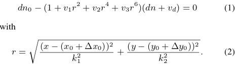
The radiometric model includes the Bidirectional Reflectance Dis-tribution Function (BRDF) proposed in (Beisl and Woodhouse, 2004) which is based on Sun position, sensor orientation and ter-rain surface parameters(a, b, c, d, e). Thus, the terrain has to be classified a priori depending on its reflectance properties. The Beisl-Woodhouse BRDF is given by
ρ(θi, θr, ϕ, a, b, c, d, e) =
DN = aLs+ b
Ls= L0+Li L0
Li S
Td
Tu s
Figure 1: RTM scheme.
Figure 2: BRDF angles.
2.5 Radiometric block adjustment
The camera calibration model, the BRDF model and the atmo-spheric RTM are integrated in the observation equation 7 for the radiometric block adjustment. We have followed a similar pro-cedure as in the standard “geometric” aerial triangulation, that is, a radiometric block adjustment with radiometric tie and control points.
The radiometric control points are ground points with measured reflectance (different for each channel: red, green, blue) and whose ground coordinates are known.
The radiometric tie points are derived from the geometric tie points by identifying near by points whose local area (10 x 10 pixels) ex-hibits an homogeneous colour intensity. Once the radiometric tie point is chosen, the translation between this point and the geomet-ric tie point is applied to all the images in which the geometgeomet-ric tie point was in order to get the position of this radiometric tie point in each image.
Considering equations 1, 3, 4 and 6, the problem to be solved in the radiometric block adjustment is to minimize the residuals (vij) of the following equation:
DNij+vij=ar(aa(L0+
ρ ρiS T 2
π(1−sρρi)) +ba) +br. (7)
vijis the residual of the observationDNijat the radiometric tie pointiin the imagej. aaand ba correspond to the offset and gain of the sensor for the whole block, whilearandbrstand for the offset and gain for each image of the block.
For the radiometric control points, we use the usual pseudo-obs-ervation equation
lρi+vρi=ρi (8)
beinglρithe reflectance value measured for a radiometric control
point,vρits residual andρithe unknown reflectance parameter.
The parameters to be estimated areaa,ba,L0,T andsfor the whole block,arandbrfor each image,a,b,c,dandefor each terrain group andρifor each tie point. In this particular research and preliminary testing we “stabilized/weighted” the image de-pendentar andbr parameters to their “normal” values 1 and 0 respectively as the radiometric network strength is not sufficiently strong.
The above models were coded and implemented as C++ classes of a “radiometric toolbox” that run on the generic network adjust-ment platform GENA (Colomina et al., 2012).
3 DRM GENERATION
The Digital Radiometric Model (DRM) is, as mentioned, a digital model which, for each ground point, gives its reflectance value and the corresponding BRDF.
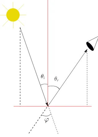
Parameter σ Units
Table 1: Radiometric block adjustment: precision of results.
For any image of the block, for each pointi, given the colour intensity (dni) and considering all the adjusted parameters, its reflectance (ρi) is computed, for each channel as follows:
dni−→Ai−→ρi (9)
From the DRM it is now easy to generate both continuous or-thophotos and “radiometrically corrected” images for arbitrary Sun and sensor position and orientation. For example, one can assume that the total upward transmittance from ground to the sensor and the total downward transmittance from the Sun to the ground is the whole solar irradiance, that is,T = 1; further, that there is no fraction of the upward radiance which is backscattered by the atmosphere, thus,s= 0; and finally, that the Sun and the sensor are oriented in a way such thatθi=θr=φ= 0.
The corrected intensity colour value (dnc
i) is computed then as
In order to validate the proposed approach, we present the pre-liminary results for a photogrammetric flight over Extremadura (Spain) with the UltraCam Xp-WA camera.
4.1 Photogrammetric data acquisition
In June and July 2010, a fligth over an area of 750000 Ha was performed in the NW of Extremadura (Spain). While the flight was taking place, 5 groups of 6 radiometric ground control points (RGCP) per group were measured. 4 groups were located at the block corners and 1 at the block centre. Each radiometric con-trol point consisted of a 2 x 2 m2 radiometric target. Within a group six colours were used, one per RGCP: red, green, blue, gray, white and black. For each RGCP both the reflectance and the radiance was measured with the ASD FieldSpec 3 spectro-radiometer. The Ground Sampling Distance (GSD) is approxi-mately 45 cm and forward- and cross-overlap is of60%and30%, respectively.
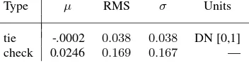
Type µ RMS σ Units
tie -.0002 0.038 0.038 DN [0,1] check 0.0246 0.169 0.167 —
Table 2: Residuals (radiometric tie points) and differences (radio-metric check points).
The camera used is the UltraCam Xp Wide Angle S/N UC-SXp-wa-50814031, a frame camera with multispectral capacity. The sensor unit is composed of 8 cones (or independent cameras): 4 of them capture the panchromatic image while the other 4 generate the multispectral image.
From the aerial triangulation geometric tie points, the radiometric tie points were calculated as described in section 2.5. In addition, the image and ground coordinates of the RGCP were measured and computed respectively. All these, resulted in a radiometric block of 337 images, 4764 radiometric tie points and 21577 ra-diometric image measurements. For this preliminary analysis the 4 corner RCGP groups were used as actual control and the central RCGP was used for check purposes.
The precision of the radiometric image measurements (DN) nor-malized to the [0,1] range is 0.03 and the RGCP were considered error free.
Last not least, we acknowledge that an important limitation of the data used was the post-processed nature of the images since we had no access to the raw image data.
4.2 Block adjustment and preliminary results
For the whole block, an homogeneous surface is assumed, thus, there are just three set of BRDF paranetersa,b,c,d, ande; one for each colour channel. As mentioned,arandbrare assumed to be different for each image but stabilized around “normal” values 1, 0 withσar = σbr = 0.01due to correlations withaa and
ba. Since atmospheric conditions did not change much during the flights there is just one ART parameter setT,sandL0. Last, for each radiometric tie point and colour channel one parameter ρiis to be estimated.
Tables 1 and 2, summarize the results obtained with the previ-ously described models, data and settings. All estimated parame-ters are significant and within reasonable range of values. Resid-uals in the six RGCPs of the central group are reasonably low biased (0.02 [0,1]-normalized DN) altjough the dispersion (0.16 may seem too large). We will not enter a detailed discussion of these results as they are preliminary and, at this point in time of the research, the consistency and quality of the orthophoto mo-saics is our main quality criteria.
4.3 Quality of mosaics
Figure 3: Original orthophoto mosaic (part 1)
Figure 4: Corrected orthophoto mosaic (part 1)
In Figures 3 and 5 the orthophoto mosaics with original images are shown, while in Figures 4 and 6 the same orthophoto mo-saics are presented, but with the radiometrically corrected im-ages. Figures 3 and 4 correspond to one part of the DTM (part 1) and Figures 5 and 6 correspond to another part (part 2). Compar-ing both orthophoto mosaics, it is observed that the radiometric differences are largely reduced with the corrected images. Ac-cording to local expertts, figures 4 and 6, exhibit more realistic colours than figures 3 and 5.
5 CONCLUSIONS
We have presented our preliminary modeling experiences and re-sults of a radiometric block adjustment with the Beisl-Woodhouse BRDF and ART models. We have validated our results through radiometric check points and the inspection of seam lines of or-thophoto mosaics.
We have introduced the concept of the Digital Radiometric Model for the terrain. DRMs of the Earth surface allow the generation of orthophotos with selectable Sun orientation, atmospheric con-ditions and sensor orientation. Actually, this is just a particular
Figure 5: Original orthophoto mosaic (part 2)
application of the DRM, since DRM allow to generate realistic views of the Earth surface for, as mentioned, selectable Sun, at-mospheric and sensor parameters, Thus, with the knowledge of the DRM together with elevation models, not only the classical cartographic operations are feasible, but also 2D and 3D realistic simulations.
Although the materials used, namely the images from the Ul-tracam Xp Wide Angle S/N UC-SXp-wa-5081403 were not raw images and had already undergone commercial software correc-tions, the results were more than acceptable from the very begin-ning as shown by the residuals of the check points and by the unnoticeable mosaic seam lines. This indicates the robustness of the procedure probably due to the use of the radiometric control points. On the other side, we must acknowledge that the radio-metric homogeneity of the test area have made things easy as we did not have to classify the terrain according to its reflectance properties.
5.1 Further work
The reported results are preliminary and a better understanding of the behaviour of the BRDF and ART models is required. More-over, in the reported experimental campaign, a single set of BRDF parametersa, b, c, d, ewas estimated. For more practical and re-alistic rere-alistic results, the terrain shall be classified into different surface types and even charecterize a priori some BRDF parame-ters. Thus, we will extend the method to inhomogeneous terrain areas and start with the usual four groups: asphalt, grass, water and sand. Use of the terrain inclinations is also planned. A last open point is the use of raw image data as opposed to the already pre-processed images. We plan on repeating the test if we get access to the raw images of the used Ultracam.
6 ACKNOWLEDGEMENTS
The research reported in this paper was carried out in the frame of the AUTORADCOR project that was partially funded by the “Centro para el Desarrollo Tecnol´ogico Industrial” (CDTI), “Min-isterio de Econom´ıa y Competitividad”.
Revised April 2013
REFERENCES
Beisl, U. and Woodhouse, N., 2004. Correction of atmospheric and bidirectional effects in multispectral ads40 images for map-ping purposes. Proc. XXth Congress of the ISPRS, Istanbul, Turkey p. 5.
Beisl, U., Telaar, J. and Sch¨onermark, M. V., 2008. Atmospheric correction, reflectance calibration and brdf correction for ads40 image data. The international archives of the photogrammetry, Remote sensing and spatial information science, Vol. XXXVII, Part B7, Beijing pp. 7–12.
Chandelier, L. and Martinoty, G., 2009. A radiometric aerial tri-angulation for the equalization of digital aerial images and or-thoimages. Photogrannetric Engineering and Remote Sensing 75(2), pp. 193–200.
Colomina, I., Bl´azquez, M., Navarro, J. A. and Sastre, J., 2012. The need and keys for a new generation network adjustment soft-ware. International Archives of Photogrammetry, Remote Sens-ing and Spatial Information Sciences. 2012 August, September, Melbourne, Australia. pp. 303–308.
Falala, L., Gachet, R. and Cunin, L., 2008. Radiometric block-adjustment of satellite images reference3dRproduction line
im-provement. The international archives of the photogrammetry, Remote sensing and spatial information science, Vol. XXXVII, Part B4, Beijing pp. 319–323.
Goldman, D. B., 2010. Vignette and exposure calibration and compensation. Pattern Analysis and Machine Intelligence, IEEE Transactions on 32(12), pp. 2276–2288.
Honkavaara, E., Arbiol, R., Markelin, L., Martinez, L., Cramer, M., Bovet, S., Chandelier, L., Ilves, R., Klonus, S., Marshal, P., Shl¨apfer, D., Tabor, M., Thom, C. and Veje, N., 2009. Digital airbon photogrammetry a new tool for quantitiative remote sens-ing? a state-of-the-art review on radiometric aspects of digital photogrammetric images. Remote Sensing 1(3), pp. 577–605.
Honkavaara, E., Hakala, T., Markelin, L., Rosnell, T., Saari, H. and M¨akynen, J., 2012a. A process for radiometric correction of UAV image blocks. Photogrammetrie Fernerkundung Geoinfor-mation 2012(2), pp. 115–127.
Honkavaara, E., Markelin, L., Rosnell, T. and Nurminen, K., 2012b. Influence of solar elevation in radiometric and geometric performance of multispectral photogrammetry. ISPRS Journal of Photogrammetry & Remote Sensing 67, pp. 13–26.
Olsen, D., Dou, C., Zhang, X., Hu, L., Kim, H. and Hildum, E., 2010. Radiometric calibration for agcam. Remote Sensing 2, pp. 464–477.
Richter, R. and Schl¨apfer, D., 2002. Geo-atmospheric pro-cessing of airbone imaging spectrometry data. part 2: Atmo-spheric/topographic correction. International Journal of Remote Sensing 23(13), pp. 2631–2649.