MULTI SENSOR AND PLATFORMS SETUPS FOR VARIOUS AIRBORNE
APPLICATIONS
G.Kemper a, R. Vasel b* a
GGS GmbH,Speyer / Germany – [email protected] b Aerial SurveyS GmbH /Germany - [email protected]
Commission I, WG I/3
KEY WORDS: Multi Sensor, Thermal, Application
ABSTRACT:
To combine various sensors to get a system for specific use became popular within the last 10 years. Metric mid format cameras meanwhile reach the 100 MPix and entered the mapping market to compete with the big format sensors. Beside that also other sensors as SLR Cameras provide high resolution and enter the aerial surveying market for orthophoto production or monitoring applications. Flexibility, purchase-costs, size and weight are common aspects to design multi-sensor systems. Some sensors are useful for mapping while others are part of environmental monitoring systems. Beside classical surveying aircrafts also UL Airplanes, Para/Trikes or UAVs make use of multi sensor systems. Many of them are customer specific while other already are frequently used in the market. This paper aims to show some setup, their application, what are the results and what are the pros and cons of them are.
1. DUAL/TRIPLE MAPPING CAMERA SETUP:
Wide area mapping to generate orthophotos either requests a big format sensor or alternatively a setup with 2 or 3 mid-format cameras that can be used for ultra wide corridors. In order to save flight lines for a mapping project in the desert area of Sudan, a system using 3*80 MPIX Phase One IXA 180 Cameras, each with a 150 mm lens, was designed. With an overlap of 20% between the single images, a synthetic frame of 26.800*7.752 pixels was achieved. Thus, even bigger than the upcoming DMC-3, a good image quality due to 5.2 µm pixel size can be expected. The long focal length and the short forward length result in a low vertical resolution and limit the use for 3D mapping. Nevertheless for Orthophoto-production the extraction of the DTM is sufficient and gives at a GSD of 10 cm an average accuracy of 32 cm in height.
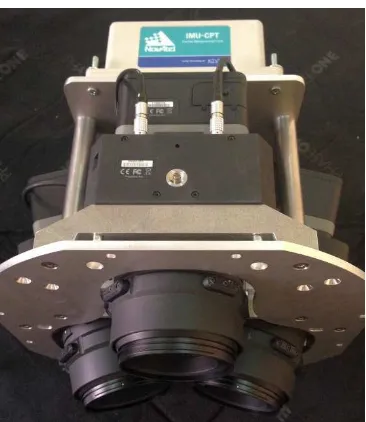
Figure 1: setup of a camera-triple with GNSS-INS
Figure 2: overlap-analysis of the test-area Khartoum
A key-issue was the processing of the data without any stitching of the triplet before. Processing the single images in standard AT software creates problems for the mathematical models to solve identical projection centers with very different projection angles. Even the offset-angles are known, it can cause limits in detecting suitable tie-points. Using some actual software tools, designed for UAVs, a first alignment was successfully solved (e.g. Photoscan) and the results transferred then to other adjustment softwares (e.g. Bingo).
To map the railway-corridor from Khartoum to Port Sudan the calibration was important in order to reduce the number of GCPs in the desert area. Using AeroDiDOS GNSS-IMU, a robust mounting of the cameras and a completely by the IMU controlled stabilized mount became part of the setup. A test-field near Khartoum was used for a calibration flight to determine the borside angles. With an error of better than 0.5 pixels, the system was that way prepared for the final mission.
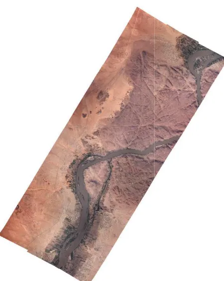
Figure 3: Orthophoto-mosaic of the Wa Orthophoto and a core DTM were the fin delivered a robust and good re
2. MULTI CAMERA FOR SEABIRD
One system was created to support environm very high resolution of 2 cm GSD to seabirds. Not high accurate geometric imag for this application, the optimal image qualit of observations have been the main target. T cameras with 110 mm lens defined the opti order not disturbing the birds, still to be ab clouds and to be higher than the rotors of of Both cameras make use of FMC for the 2 mounted with only 5% overlap on a gyro-sta data capturing was achieved with a spec designed for the fastest possible data t accuracy of 2 cm and the attitude of about enough for a proper geo-localization of special tool preselect images with and automatically to assist the semi-automated f The problem of glare effects is planned to b a third camera in the NIR band.
In a new project the implementation of GNS direct referenced images will help in a bet correlation especially if the NIR will be compensation. That way, a better algorithm the images can be expected to make a autom possible
ad al Basal area final products that d result.
D MONITORING
nmental monitoring in o identify and count ages were major goal ality and a big number Two Phase One IXA ptimal flight height in able o fly below the off-shore wind farms. 2 cm GSD and were stabilized mount. Fast pecial computer rack transfer. The GPS t 0.5 degree are fine f the birds. Using a and without objects d following workflow. o be adjusted by using
NSS-INS to get better better image to image e used for the glare hm to detect birds on omated data-extraction
Figure 4: Screen shot of a softwar identification (example image
3.
4. AGRICULTURAL
For the scientific research AirAg monitoring by using modified SL edge in the NIR bands has bee limitations, the system was design just equipped with a Dual frequ master camera a Rollei Metric 25 was used with additional 2 modifi captured images in NIR. In that c used as a master while the oth resulted accuracy in co-registrati while the relative accuracy betwee a pixel.
The Nikon cameras use a bayer p sensitive in the NIR. Using h balancing the Bayer pattern and the done before entering the AT and o quantitative analysis of the chlorop
Figure 5: Setup of a metric RGB Ca for capturing images in the N
ware interface used for species ge shows a juvenile gannet)
AL APPLICATION
rAgro a setup for agricultural SLR cameras to detect the red een created. Due to financial igned most cost-effectively and quency GNSS receiver. As a 25 MPix camera (P25) as RGB dified Nikon SLR cameras that at case, the metric camera was thers were co-registered. The ation was better than 1 pixel een the images was about ¼ of
r pattern which is not equally homogeneous NIR areas, a the vignetting of the lenses was ortho-rectification. That way a ophyll activity was possible.
B Camera and 2 modified Nikon e NIR red edge spectrum
Figure 6: CIR image generation from the RG and the NIR Nikon images after
co-5. RGB AND THIR CAMERAS
Thermal sensors measure thermal emissions of 7.5 - 14 µm. The relative thermal sensitiv is very good while the absolute rec information is depended on many facto surface structure, athmospheric absorption… for anomalies is the typical goal. One senso made for water and/or humidity detection especially soils. The combination of a ther RGB camera is not very common because daylight camera application while Therma captured in the nighttime. However, during get results with a thermal camera that must different way. Temperature differences can the absorption of materials (e.g. dark soils), (south oriented roofs or hills) and materials t in a specific way. Besides that, water in soils causes heat loss due to evapo-transpiration reacts as a huge accumulator. For the proper then make use of the RGB image. That w humid and dry soils and also water infil structures (bridges…).
RGB Master camera -registration.
ASYSTEM
ons in the wavelength itivity of such sensors received temperature ctors e.g. emissivity, n…. Finally the search nsor-combination was n in the environment hermal sensor with an use RGB is a typical mal data usually are ring daytime you also ust be interpreted in a an be detected due to s), from the inclination ls that accumulate heat ils or the environment ion while open water per interpretation, you t way, you can detect filtration in artificial
Figure 7: Thermal image overlai daytime survey for monitoring city water bodies reduce the temp
rlaid over an Orthophoto of a ity climate. Green areas close to
perature by transpiration.
6. OBLIQUE IMAGING
Oblique imaging became very popular within that way of capturing images was already decades. Besides architectural oblique imag mining and other special tasks oblique imag long time. About 8 years ago, there was a such data, either for homeland-security iss applications as Bing, Virtual Earth, Google others. Cameras mounted between 30 and 5 are typically defined as oblique. With some georeference to display the data on the appro map was sufficient. Besides that, the i resolution of the cameras was poor that tim data was situated in specific segments only.
Im this causes problems when using direct refer that reason, a Multi Snap controller that sy the single cameras solves this issue so that f separated and related to each single camera. device is patented and has been tested succes
Figure 9: 3D result as coloured point-clou Jerusalem
ING
thin the last years even ady used since many proximate place over a image quality and time. The use of such
Figure 8: Oblique Imager based on SLR
Cameras Actually we can make use of SLR Cameras that capture images with 36-50 systematically delays at finally each event is ra. This asynchronous cessfully.
loud of the DSM of
The geometric result of this SLR Ca is 0.6 pixels, an extremely good res Cameras are supposed to be non and that they use a focal plan deviations during exposure.
The more precise way is to make format sensors and central leaf shu 50-100 MPIX. Not the higher res image geometry of such mapping c using these data for precise mappin of such cameras are in the field o generate high dense DSMs with a and a high redundancy of image facades. A system with 5 mid-fo PhaseOne IXA/IXU technology integrated data-unit, a robust and used for mapping the urban devel for the nadir camera and 4*50 MP under 40 tilt angles build the b stability was the goal to achieve hi for a proper 3D evaluation. The sys fit into a standard gyro- mount in c Pos AV GPS-IMU System. AeroT for oblique mission planning a calibration of Cameras, offsets, b floating lever arms was a diff calibration procedure. Finally, a solution was designed.
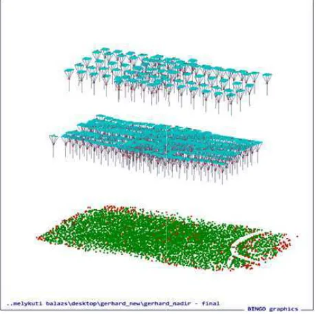
Figure 10: adjustment of the Tie-p adjustment in
The aero triangulation results are i 1/3rd of a pixel. The adjustment an orientation was applied directly to not via the path of co-registration. and better error detection is possibl In Summer 2015, a complex calibr over the GGS test-field of Speye camera stability and do the comp results are a calibration of the singl
R Camera based Oblique Imager result if we are aware that these n metric even when calibrated lane shutter that cause some
e use of cameras with medium shutter that capture images with resolution only, also the precise g cameras widened the range of ping and modelling too. The use of precise 3D City models, to a extreme good high accuracy ge data in order to texture the format cameras based on the gy was developed. With an d most accurate Sensor is now velopment in Taiwan. 80 MPix Pix Cameras for the 4 aspects basis of this sensor. Camera high reliable and accurate data system was designed in order to n combination with an Applanix oTopoL is used with its option and as FMS. Besides that, , bore side angles and solving ifficult task in the complex a highly accurate and reliable
points during the bundle bock t in Bingo
re in the typical metric range of and use of the external airborne to each camera, which means on. That way a better accuracy ible.
ibration flight on 2 flight levels eyer was done to validate the mplete calibration process. The ngle cameras, the relative angles
of the oblique sensors to the nadir one, th angles to the IMU and the calibration of the s
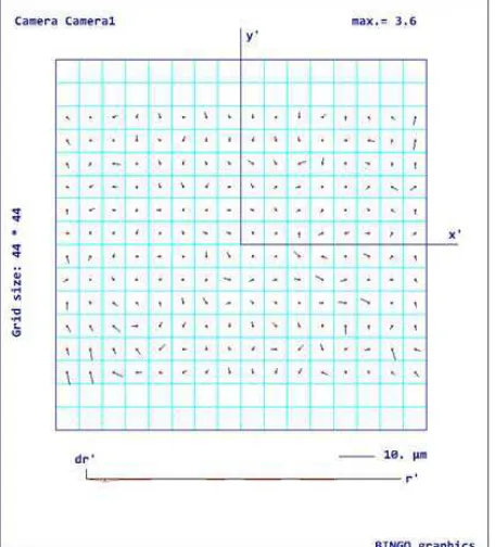
Figure 11: the remaining errors and their dir on a selected camera.
Figure 12: the remaining errors and their dir on a selected camera
The result has shown that the developed 5he mapping 3D Sensor.
REFERENCES
VASEL,R.,KEMPER,G.,SCHUHMANN,R.,KÖ
New airborne Thermal Infrared photogramm and sensors for moisture detection; Proceedin Congress 2008 in Beijing.
, the absolute borside e single sensors.
directions can be seen
directions can be seen
head camera is a fully
ÖNIGER,F. (2008): metric applications dings of the ISPRS
CAO LI,LI HONGBO,KEMPER, G. (2 development of small Chinese citie surveying technologies; Proceeding 2008 in Beijing
KEMPER,G.,LI HONGBO,PAULY,K
Sensors and Platforms for specific Photogrammetry and remote sensin Congress 2008 in Beijing
HINE,D.,KEMPER,G.,PIVNICKA,F. Innovation in Flight Management S topological GIS Analysis; Proceedi 2008 in Beijing.
KEMPER,G.,VASEL,R.(2009): Luf Überwachung von Bauwerksschäde Feuchtemessung in Forschung und Workshop 2009, Karlsruhe BARMETTLER,A.,NEBIKER,S.,KEM
M.,STUTZ,C.,PETER,M.,(2010) ai Fernerkundungslösung für die Agro Leichtflugzeugen und Minidrohnen OVG und SGPBF Wien.
KEMPER,G. (2010): Neue luftgestü Plattformen für verschiedenste Auf 3 Ländertagung der DGPF, OVG u MALLAST,U.,SCHWONKE,F.,SIEBE
KEMPER,G.,GEYER,S.,KÜHN,F. (2
flugzeuggestützte Thermalfernerku submariner und terrestrischer Grun hochsalinaren Uferzone des Toten M Erste Ergebnisse von Befliegungsk Toten Meeres im Januar 2011: DGPF Jahrestagung in Mainz 2011 KEMPER,G.(2012): New Airborne Solving Specific Tasks in Remote S Congress, ISPRS Proceedings, Mel KEMPER,G.,PIVNICKA,F.,GEISSLE
Procedures in Mid Format Camera Congress, ISPRS Proceedings, Mel VASEL,R.,KEMPER,G.,SCHUHMAN
New airborne thermal infrared phot and sensors for moisture detection; ISPRS Proceedings, Melbourne/ Au KEMPER,G./SCHUHMANN,R./KÖN
airbone thermal infrared photogram sensors for moisture detection; Proc International Conference on Electro with Water and Moist Substances ( September 2013, 423-431. Kupfer, COPPACK,T.,·WEIDAUER,A.,·KE
von Seevogel- und Meeres-säugerb georeferenzierter Digitalfotografie; und Fachmesse Angewandte Geoin Österreich, Volume: AGIT - Journa Geoinformatik, 1-2015
_____________________ * Corresponding author
. (2008): Monitoring urban ities using innovative aerial
ings of the ISPRS Congress
K. † (2008): New airborne ic applications in
sing; Proceedings of the ISPRS
F.,LI HONGBO (2008): t Systems using real-time edings of the ISPRS Congress
uftgestützte Thermographie zur äden; Innovative
nd Praxis 4, Berichtsband zum
EMPER,G.,KOCH,C,SCHMUTZ, ) airAGro –
gronomie auf der Basis von nen. 3 Ländertagung der DGPF,
stützte Sensoren und
ufgaben in der Fernerkundung. und SGPBF, Wien.
skampagnen am Westufer des 11
ne Sensors and Platforms for te Sensing; XXII ISPRS
elbourne/ Australia
LER,S. (2012): Calibration ra Setups; XXII ISPRS
elbourne/ Australia.
ANN,R.,KÖNIGER,F. (2012): hotogrammetric applications
n; XXII ISPRS Congress, Australia.
ÖNIGER,F. (2013): New ammetric applications and roceedings of the 10th ctromagnetic Wave Interaction
s (ISEMA), Weimar, 25.-27. er, K. [Hrsg.]
EMPER,G. (2015): Erfassung
erbeständen mittels
ie; AGIT 2015 – Symposium oinformatik, At Salzburg,
rnal für Angewandte