Open Geospatial Consortium Inc.
Date:2009-01-15
Reference number of this OGC® document: 07-092r3
Version:1.3
Category:OGC® Best Practices
Editor:Arliss Whiteside
Definition identifier URNs in OGC namespace
Copyright © 2009 Open Geospatial Consortium, Inc. All Rights Reserved. To obtain additional rights of use, visit http://www.opengeospatial.org/legal/.
This document defines an OGC Best Practices on a particular technology or
approach related to an OGC standard. This document is not an OGC Standard and may not be referred to as an OGC Standard. It is subject to change without notice. However, this document is an official position of the OGC membership on this particular technology topic.
Document type: OGC® Best Practices Document subtype:
Contents
Pagei. Preface ... iv
ii. Document contributor contact points ... iv
iii. Revision history ...v
iv. Changes to the OGC Abstract Specification ...v
v. Future work ...v
Foreword ... vi
Introduction ... vi
1 Scope ...1
2 Conformance ...1
3 Normative references ...1
4 Terms and definitions ...3
5 Conventions ...5
5.1 Symbols (and abbreviated terms) ...5
5.2 Document terms and definitions ...5
6 Background ...6
6.1 Definition identifiers ...6
6.2 Use for Coordinate Reference Systems ...6
6.3 Relationships to other identification schemes ...7
6.3.1 URN and URL ...7
6.3.2 URN and schema component designators...8
7 OGC URN scheme for definitions ...9
7.1 OGC URN scheme ...9
7.2 URNs for single objects ...9
7.3 URN extensions for OGC ...13
7.4 URNs for not-completely-specified objects ...14
7.5 URNs for combined objects ...15
7.5.1 Overview ...15
7.5.2 URN combined references for compound coordinate reference systems ...16
7.5.3 URN combined references for concatenated operations ...16
7.5.4 URN combined references for projected or derived CRSs ...17
7.5.5 URN combined references for datum and coordinate system ...17
8 URN values for definitions and concepts in ogc namespace ...17
8.1 Introduction ...17
8.2 CRS definitions ...18
8.3 CRS code list values definitions ...18
8.4 Unit-of-measure (uom) definitions ...21
8.5 Data type definitions ...21
Annex A (normative) GML dictionaries of OGC definitions ...24
A.1 Introduction ...24
A.2 Definitions of derivedCRSType values ...24
A.3 Definitions of verticalDatumType values ...26
A.4 Definitions of pixelInCell values ...27
A.5 Definitions of rangeMeaning values ...27
A.6 Definitions of axisDirection values ...28
A.7 Definitions of units-of-measure ...34
A.8 Definitions of data types ...35
Bibliography ...40
Tables
Page Table 1 — “authority” values for definitions in OGC URN namespace ... 11Table 2 — “objectType” values for definitions in OGC URN namespace ... 12
Table 3 — URNs for CRSs defined by OGC ... 18
Table 4 — URNs for derivedCRSType values ... 19
Table 5 — URNs for verticalDatumType values ... 19
Table 6 — URNs for pixelInCell values ... 19
Table 7 — URNs for rangeMeaning values ... 19
Table 8 — URNs for axisDirection values ... 20
Table 9 — URNs for units-of-measure ... 21
Table 10 — URNs for data types ... 22
i.
Preface
This version 1.2 includes Corrigendum 2 as specified in [OGC 06-152r1].
This Best Practices Paper specifies Universal Resource Names (URNs) in the “ogc” URN namespace to be used for identifying definitions. This document specifies the formats used by these URNs, plus a set of specific URNs for specific definitions. These definitions should be used wherever applicable by implementations of various OGC Implementation Standards, including GML, WMS, WFS, and WCS.
In this version of the document several modifications are made to reflect the fact that the EPSG dataset is now available in a data registry (www.epsg-registry.org). Furthermore some modifications reflect a change in Topic 2 - Spatial Referencing by Coordinates.
This document does not require or encourage OGC standards to use only URNs defined in the "ogc" URN namespace. In addition, it does not encourage use of URNs when URLs are appropriate. Furthermore, other OGC documents do and can specify more URNs in the "ogc" URN namespace.
However, OGC standards should specify that all URI values used with that standard have well-specified formats and meanings, preferably electronically accessible meanings. If well-specified URI values are not available for an OGC standard need, specification of new URNs in the "ogc" URN namespace should be considered (in that standard or elsewhere). If new URNs are being specified in another URN namespace for use with OGC standards, it would be useful if the same URN structure is used as is used by the OGC.
Suggested additions, improvements, and comments on this Best Practice are welcome and encouraged. Such suggestions may be submitted to the editor by email message. Extensive and/or multiple changes can be suggested by making changes in an edited copy of this document. If you choose to submit suggested changes by editing this document, please make your suggested changes with change tracking on.
ii.
Document contributor contact points
All questions regarding this document should be directed to the editor or the contributors:
Name Organization
Arliss Whiteside BAE Systems E&IS
John Evans NASA / GST, Inc.
Keith Pomakis CubeWerx, Inc.
Simon Cox CSIRO Exploration and Mining Roel Nicolai Shell International E and P
iii.
Revision history
Date Release Editor Primary clauses modified
Description
2004-12-17 0.0.0 Arliss Whiteside
All Initial version
2005-01-07 0.0.0 Arliss Whiteside
7.1, 7.2 Adds information on referencing EPSG coordinate axis objects
2005-01-26 1.0.0 Arliss Whiteside
Cover, i, 7.1, 7.2 Removed information on referencing EPSG coordinate axis objects, edited as approved Recommendation Paper
2006-02-13 1.0.1 Arliss Whiteside
Cover, i, 7.1, 7.5, A
Added additional allowed “authority” and “objectType” values, plus URNs for data types 2006-07-04 1.0.2 Simon
Cox
v, 6.1, 6.3, 7.1 Add to future work, TBD 2006-07-24 1.1.0 Arliss
Whiteside
All Final editing
2007-07-27 1.1.2 Arliss Whiteside
Make changes described in Corrigendum 2 [OGC 06-152r1]
2007-09-28 1.1.2 Arliss Whiteside
Cover, iii Cleanup following approval 2008-08-22 1.2 Roel
Nicolai
7.2 , 8.3, Annex A
Extension objectTypes by Area; removal of conditional mandatory nature of ‘version’ in URN; update with changes to Topic 2
2008-10-06 1.3 Roel Nicolai
7.2 , 8.3, Annex A
Includes final edits of version 1.2; extension of list of objectTypes rejected.
2009-09-09 1.3 Carl Reed Various Minor edits in preparation for publication as BP
iv.
Changes to the OGC Abstract Specification
The OGC® Abstract Specification does not require changes to accommodate the technical contents of this document.
v.
Future work
Improvements in this document are desirable to:
a) Add more and complete existing examples in Clause 7
b) Specify additional URNs in Clause 8
c) Specify meanings of additional URNs in Annex A
d) Replace static list of Authorities with dynamic registry (hosted by OGC Network)
e) Replace the static list of Object Types with dynamic registry
f) Point to standard resolution service for OGC URNs
vi Copyright © 2009 Open Geospatial Consortium, Inc. All Rights Reserved.
Foreword
This document includes one normative annex: Annex A.
Attention is drawn to the possibility that some of the elements of this document may be the subject of patent rights. The Open Geospatial Consortium Inc. shall not be held responsible for identifying any or all such patent rights.
Recipients of this document are requested to submit, with their comments, notification of any relevant patent claims or other intellectual property rights of which they may be aware that might be infringed by any implementation of the standard set forth in this document, and to provide supporting documentation.
Introduction
This document specifies Universal Resource Names (URNs) in the “ogc” URN
namespace to be used for identifying definitions. These definitions include definitions of Coordinate Reference Systems (CRSs) and related objects, as specified in OGC Abstract Specification Topic 2: Spatial referencing by coordinates, plus several other resource types for which standard identifiers are useful in OGC Web Services. This document specifies the formats used by these URNs, including formats that can reference
Copyright © 2009 Open Geospatial Consortium, Inc. All Rights Reserved. 1
Definition identifier URNs in OGC namespace
1 Scope
This document specifies Universal Resource Names (URNs) in the “ogc” URN
namespace to be used for identifying definitions. These definitions include definitions of Coordinate Reference Systems (CRSs) and related objects, as specified in OGC Abstract Specification Topic 2: Spatial referencing by coordinates. This document specifies the formats used by these URNs, including formats that can reference any definition recorded in the EPSG database. This document also specifies URNs for some specific definitions.
This document specifies URN formats for several uses, currently including referencing definitions of:
a) Single objects
b) Not-completely-specified objects
c) Combined objects
Most XML attributes and elements with the anyURI data type that reference definitions, in all approved and draft OGC Implementation Standards, can use a URN value in the “ogc” URN namespace. Such a URN shall be used when a URL cannot be used to electronically access that definition, by all clients and servers that may need to reference that definition.
The “ogc” definition URNs specified here should be used wherever applicable by implementations of all approved and draft OGC Implementation Standards, including GML, WMS, WFS, and WCS. Additional definition URNs in the “ogc” URN namespace are and will be specified in other OGC documents.
2 Conformance
Conformance with this Best Practice shall be checked using all the relevant tests
specified in each separate specification that normatively references this Best Practice, and specifically references the applicable parts of this Best Practice.
3 Normative references
amendments to, or revisions of, any of these publications do not apply. For undated references, the latest edition of the normative document referred to applies.
European Petroleum Survey Group database: EPSG Geodetic Parameter Dataset, available through http://www.epsg.org/ and accessible on-line through www.epsg-registry.org
IETF RFC 2141 (May 1997), URN Syntax, R. Moats <http://www.ietf.org/rfc/rfc2141.txt>
IETF RFC 2396 (August 1998), Uniform Resource Identifiers (URI): Generic Syntax, Berners-Lee, T., Fielding, N., and Masinter, L., eds.,
<http://www.ietf.org/rfc/rfc2396.txt>
ISO/IEC 18025:2005, Information technology — Computer graphics and image
processing — Environmental Data Coding Specification (EDCS)
ISO 31:1992, Quantities and Units. (13 Parts, with revisions 1998)
ISO 1000:1998, The International System of Units (SI), 7th edition
ISO 19109:2004. Geographic information - Rules for application schema
OGC 03-105r1, OpenGIS Geography Markup Language (GML) Implementation
Standard, Version 3.1.0
OGC 06-166, A URN namespace for the Open Geospatial Consortium (OGC), draft
OGC 06-042, Geographic information — Web Map Service interface, v1.3.0
OGC 04-092r4, OpenGIS Geography Markup Language (GML) Implementation
Standard Schemas, Version 3.1.1
OGC 06-121r3, OGC Web Services Common Standard, Version 1.1.0
OGC 05-020r5, Technical Committee Policies and Procedures
OGC 05-087r2, Observations and Measurements
OGC 05-096r1, GML 3.1.1 grid CRSs profile
OGC 05-099r2, GML 3.1.1 simple dictionary profile
OGC 08-015, The OpenGIS Abstract Specification, Topic 2: Spatial Referencing by
Coordinates
OGC 05-108r1, Geographic information — Geography Markup Language (GML)
W3C Recommendation January 1999, Namespaces In XML,
http://www.w3.org/TR/2000/REC-xml-names
W3C Recommendation 04 February 2004, Extensible Markup Language (XML) 1.0 (Third Edition), http://www.w3.org/TR/REC-xml
W3C Recommendation 2 May 2001: XML Schema Part 0: Primer,
http://www.w3.org/TR/2001/REC-xmlschema-0-20010502/
W3C Recommendation 2 May 2001: XML Schema Part 1: Structures,
http://www.w3.org/TR/2001/REC-xmlschema-1-20010502/
W3C Recommendation 2 May 2001: XML Schema Part 2: Datatypes,
http://www.w3.org/TR/2001/REC-xmlschema-2-20010502/
UCUM, Unified Code for Units of Measure, Schadow, G. and McDonald, C. J. (eds.),
http://aurora.rg.iupui.edu/UCUM
In addition to this document, this Best Practice includes several normative XML
document files. Following approval of this document, these files will be posted online at the URL http://schemas.openis.net/definitions/. These XML files are also bundled with the present document. In the event of a discrepancy between the bundled and online versions of the XML files, the online files shall be considered authoritative.
4 Terms and definitions
For the purposes of this document, the following terms and definitions apply.
4.1 client
software component that can invoke an operation from a server
4.2
document type
class or structure of a document, which implies its intended application
NOTE Some document types imply a formal structure or grammar (e.g., schemas, used for document design and validation), while for other document types the structure is more generally defined (e.g., Discussion Papers).
4.3 feature
abstraction of a real world phenomena [ISO 19109]
4.4
feature type
class for all instances of that feature type
NOTE The instances of a class that represents an individual feature type are feature instances. 4.5
interface
named set of operations that characterize the behaviour of an entity [ISO 19119]
4.6 nil
explanation for a void value or other missing information [OGC 05-108r1]
4.7
operation
specification of a transformation or query that an object may be called to execute [ISO 19119]
4.8
parameter
variable whose name and value are included in an operation request or response
4.9
phenomenon
feature characteristic, the estimation of which is the purpose of an observation [OGC 05-087r2]
NOTE A phenomenon may be a physical property (such as temperature, length, etc), a classification (such as species), frequency or count, or an existence indication.
4.10 request
invocation of an operation by a client
4.11 response
result of an operation, returned from a server to a client
4.12 server
service instance
a particular instance of a service [ISO 19119 edited]
4.13 service
distinct part of the functionality that is provided by an entity through interfaces [ISO 19119]
capability which a service provider entity makes available to a service user entity at the interface between those entities [ISO 19104 terms repository]
4.14 version
version of an Implementation Standard (document) and XML Schemas to which the requested operation conforms
5 Conventions
5.1 Symbols (and abbreviated terms)
CRS Coordinate Reference System
EDCS Environmental Data Coding Standard
EPSG European Petroleum Survey Group
GML Geography Markup Language
ISO International Organization for Standardization
OGC Open Geospatial Consortium
OWS OGC Web Service, or Open Web Service
SI The International System of Units
TBD To Be Determined
UCUM Unified Code for Units of Measure
URI Universal Resource Identifier
URL Uniform Resource Locator
URN Universal Resource Name
WCS Web Coverage Service
WFS Web Feature Service
WMS Web Map Service
XML Extensible Markup Language
1D One Dimensional
2D Two Dimensional
3D Three Dimensional
5.2 Document terms and definitions
The following terms and definitions are used in this document:
a) shall – verb form used to indicate a requirement to be strictly followed to conform to this document, from which no deviation is permitted
b) should – verb form used to indicate desirable ability or use, without mentioning or excluding other possibilities
c) may – verb form used to indicate an action permissible within the limits of this document
d) can – verb form used for statements of possibility
e) informative – a part of a document that is provided for explanation, but is not required
f) normative – a part of a standards document that is required
g) annex – an auxiliary part of a document, called an “appendix” in United States English
h) clause – a major part of a document, called a “section” or “paragraph” in United States English
i) subclause – a secondary part of a clause or annex, called a “subsection” in United States English
6 Background
6.1 Definition identifiers
The OGC URN scheme is defined in OGC Document 06-166. It specifies a family of identifiers for resources of interest in OGC Web Services, mostly resources provided or defined by the OGC.
The “def” branch of the OGC URN scheme is defined in this document. This branch provides standard identifiers for many concepts and definitions. These definitions include coordinate reference systems and related components, units of measure, nils, and various object types and definitions. These include definitions and concepts maintained by OGC and by other authorities who do not provide URNs for their concepts, but which are of importance in OGC Web Services and encodings.
The URN syntax is useful because (a) it provides persistent identifiers that are independent of resource location, while (b) being part of the URI scheme, and thus compatible with referencing in a web context. A uniform identification scheme is useful for interoperability, allowing use of short identifiers for concepts. These identifiers allow suitable software to make rapid comparisons, and to obtain values from a local cache when available, in preference to accessing definitions from a remote service.
6.2 Use for Coordinate Reference Systems
One frequent use is referencing the CRS for an OWS server input or output; another use is referencing the CRS for a feature geometry or a bounding box. These URNs are used to identify the referenced CRS, not to transfer a definition of that CRS. Most of this
material is also applicable to referencing CRS components and Coordinate Operations and their components, often referred to as objects.
NOTE 1 Subclause D.14 of [OGC 06-121r3] summarizes many of the requirements considered when specifying how to reference CRSs.
Document [OGC 06-121r3] specifies that each specific OWS shall always reference a CRS by using a XML attribute or element with the type anyURI. Such an anyURI value can be used to reference a CRS whether the definition of that CRS is included in the same data transfer, is NOT included in the same data transfer, cannot be electronically
accessed, or can be electronically accessed.
NOTE 2 In XML Schemas, the anyURI data type is the standard way to briefly reference (or cite) something specified elsewhere. XML attributes with the type anyURI include the GML defined attributes named gml:srsName, gml:uom, xlink:href, and gml:codeSpace.
When using a XML attribute or element with the type anyURI to reference a CRS, CRS-related, or other object, that URI shall have a value which uses one of two alternative URI formats:
a) Universal Resource Locator (URL), with standard form. The URL format should be used whenever the referenced definition is known to be electronically available using this standard URL.
b) Universal Resource Name (URN), with a specified form. The URN format shall be used whenever the referenced definition is not, or might not be, available using a URL. This URN shall reference data that is specified by some “authority” and is “well-known” to both client and server software, including multiple clients and multiple servers.
NOTE 3 Two widely-used forms of URI are URL and URN. We are specifying using URNs as the way of citing CRS-related definitions that are "well-known" but are not adequately electronically available using a URL.
Subclause 10.3.2 of the OWS Common standard[OGC 06-121r3] specifies when and how to use URLs to reference a CRS or CRS-related object. Use of URNs is expected to be more common than use of URLs, and specific OWS Implementation Standards are expected to specify many standard URN values.
6.3 Relationships to other identification schemes
6.3.1 URN and URL
URNs [IETF RFC 2141] are a kind of URI [IETF RFC 2396], and may be used as the value of references where a URI is required. This is often the case in GML-based encodings (e.g., the standard XML attributes xlink:href, xlink:role, xlink:arcrole, srsName, uom, codeSpace) and in OGC Web Services (OWS) operation requests and responses.
A URN serves as a persistent identifier of a resource or concept. A detailed description of the resource may also be available online, with a resource locator (URL) providing an access point. In general, there is no direct mapping or algorithm to obtain a URL for the resource designated by a URN. URNs are intended to be more persistent than URLs, so that they remain valid even if a resource description is relocated. However, a resolution service or resolver may provide a URL corresponding to a URN.
NOTE In the future it is expected that the OGC Network will provide a resolution service for URNs in the OGC scheme.
6.3.2 URN and schema component designators
In a few places in OWS interfaces, an identifier for an XML component is required. In these cases, it is important that the identifier reference the actual schema definition, which may then be used as the template for an OWS request or response.
A number of options are available for identification of schema components. The W3C XML Schema recommendation provides QName (qualified name – see XML Schema Part 2, clause 3.2.18). A QName has the lexical form ns:name where “ns” is an XML namespace prefix for which a namespace declaration is in scope. The QName thus corresponds with an identifier tuple {namespace, local name} where “namespace” is the fully scoped identifier for the XML namespace. In contrast, a URN identifier is complete, and does not depend on context for resolution of the namespace prefix.
NOTE The W3C XML activity is currently considering a more complete scheme for identification of schema components, documented in the working draft XML Schema: Component Designators [9]. In OWS interfaces, XML components are generally identified using a QName.
While there is some overlap of the meaning of schema component designators with the OGC URN scheme used for dataTypes (clause 8.5) and featureTypes, it should be understood that a URN identifies the concept, and not just its XML and XML Schema implementation. Of course, the concepts denoted by identifiers from the featureType branch generally have XML Schema implementations, so direct mappings are implied. Note that the mapping may be one-to-many, for example to manage versioning of the XML schema implementation independent of versioning of the concept.
Table 10 in Subclause 8.5 provides definitions in the dataType branch, together with mappings to a QName designation of equivalent XML schema components. That subclause provides the complete definition of URNs in the dataType branch, since “OGC” is the only authority recognised for this branch.
For the featureType branch, it is expected that many authorities will have an interest in using the “def” branch of the OGC URN scheme to provide feature type identifiers. It is incumbent on each authority to indicate the mapping from the URN form of identifier to other schema component designators, such as a QName, so that the use of these in OWS interfaces is unambiguous.
7 OGC URN scheme for definitions
7.1 OGC URN scheme
The OGC URN scheme is defined in OGC Document 06-166. It specifies a family of identifiers for resources of interest in the context of OGC Web Services, mostly concerning resources provided or defined by OGC. The OGC scheme has the form
urn:ogc:{category.label}:{ResourceSpecificString}
The category.label must be one of a set of values that are not yet specified, except that this document specifies the “def” value and the corresponding ResourceSpecificString format.
7.2 URNs for single objects
To identify the definition of a single object, the URN shall have the form:
urn:ogc:def:objectType:authority:version:code
The “urn”, “ogc”, “def”, and six “:” parts of this URN are fixed. The “ogc” part shall be the registered namespace authority for all URNs used by the OGC. The “def” part shall be the fixed category label which identifies all the OGC URNs that reference object definitions. The “objectType” part shall be an OGC-specified unique-identifier of the type of the referenced definition.
NOTE 1 The ”ogc” part denotes the namespace authority in a URN, and the value used should be registered with IANA. Pending the official registration of the OGC scheme with IETF/IANA, the value “x-ogc” should be used, where the “x” denotes an experimental namespace. The “def” part is a value for the {category.label} part specified in [OGC 06-166]. The remaining “objectType:authority:version:code” parts are values of the {ResourceSpecificString} part specified in [OGC 06-166].
The “objectType” part shall be the OGC-specified token for the type of concept identified by the URN.
NOTE 2 The set of object types denoted by the OGC URN scheme is currently specified normatively in Table 2 in this document and revisions. In the future it is expected that this mechanism will be replaced by a dynamic registry.
The “authority” part shall be the OGC-specified abbreviation for the authority organization that specified the referenced definition.
NOTE 3 The set of authorities recognised for the purposes of the OGC URN scheme is currently specified normatively in Table 1 in this document. In future it is expected that this mechanism will be replaced by a dynamic registry.
The optional “version” part shall be the version of the authority or code for the referenced definition. The “code” part shall be a unique identifier of the referenced definition, as specified by the referenced authority. The “code” part can be human-understandable, provided that it is unique for that authority, version, and objectType. In this use, all textual parts of URN values shall be case-insensitive.
The “version” part of these URNs can be omitted when the referenced definition does not have a version, and the referenced definition is not specific to an authority version. When included, the “version” shall be recorded in the format specified by the authority. The version format is sometimes “N.N.N” or “N.N”, where each “N” stands for an integer. If no other version identification is provided by the authority, a year or other date can be used. No "v" or other version prefix shall be included.
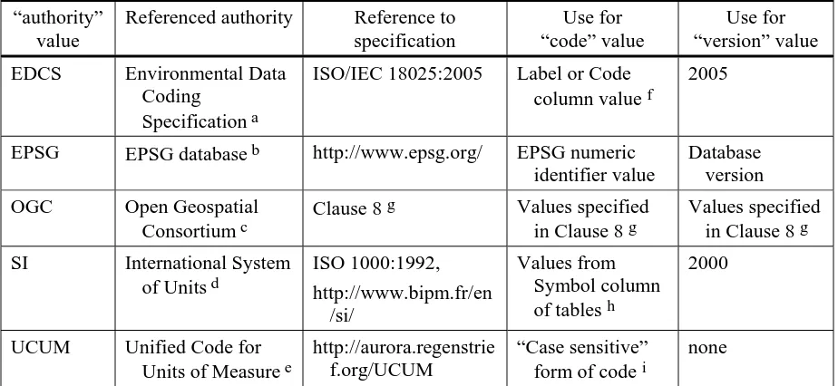
The required “authority” part identifies an authority recognized by the OGC, and the allowed “authority” values shall include those listed in Table 1. In this table, the third column references a specification for each "authority" value. All URNs that include this "authority" value shall mean exactly what is meant by that specification, when the corresponding “code” and “version” values are used.
EXAMPLE The URN value urn:ogc:def:crs:EPSG:6.6:4326 shall mean the Coordinate Reference System (CRS) with code 4326 specified in version 6.6 of the EPSG database available at
http://www.epsg.org/. That CRS specifies the axis order as Latitude followed by Longitude.
Table 1 — “authority” values for definitions in OGC URN namespace
“authority” value
Referenced authority Reference to specification
Use for “code” value
Use for “version” value
EDCS Environmental Data
Coding Specification a
ISO/IEC 18025:2005 Label or Code column value f
2005
EPSG EPSG database b http://www.epsg.org/ EPSG numeric identifier value
Database version
OGC Open Geospatial Consortium c
Clause 8 g Values specified in Clause 8 g
Values specified in Clause 8 g
SI International System
of Units d
UCUM Unified Code for Units of Measure e
http://aurora.regenstrie f.org/UCUM
“Case sensitive” form of code i
none
a The Environmental Data Coding Specification (EDCS) is recognized as an authority that specifies a vocabulary of phenomena in its Attributes dictionary (“EAs”).
b The EPSG databaseis now maintained by the OGP Surveying and Positioning Committee, and is recognized as an authority that specifies many CRS-related definitions.
c The Open Geospatial Consortium (OGC) recognizes itself as one or more authorities, here using “OGC” as the one current authority abbreviation.
d The International System of Units (SI) is recognized as an authority that specifies basic units of measure and a limited selection of derived units.
e The Unified Code for Units of Measure (UCUM) is recognized as an authority that specifies symbols for denotinga large set of basic units of measure and a grammar that defines combinations of these that correspond with symbols that are commonly used in commerce, scientific and engineering applications.
f Values from the Label or Code columns of the attribute Tables 6.5 – 6.30 of ISO/IEC 18025:2005. g The OGC shall explicitly specify each “code” and “version” value defined by the “OGC” authority. Clause 8 of this document specifies some of these codes and versions. Additional OGC codes and versions are now specified in Clause 10 of OGC 05-096r1, and more can be specified in future OGC Implementation
Specifications and Best Practices Papers.
h Plus combinations of symbols as defined in the SI specification. Note that some symbols include elements that are not available on a standard character entry device (e.g. , °C). For these units, it is recommended that the UCUM symbol and URN be used in preference. See also footnote i.
i UCUM specifies code values or symbols using the reduced character set universally available on character entry devices (“7-bit ascii"), and combinations of these generated using the grammar described in the UCUM specification. For this reason the use of UCUM codes is preferred to those specified in ISO 31:1992 [8], as the latter specifies the use of superscripts and non-latin symbols for certain units. While these are in principle supported by Unicode, for practical reasons the reduced character-set encoding is preferred for use in the URN syntax.
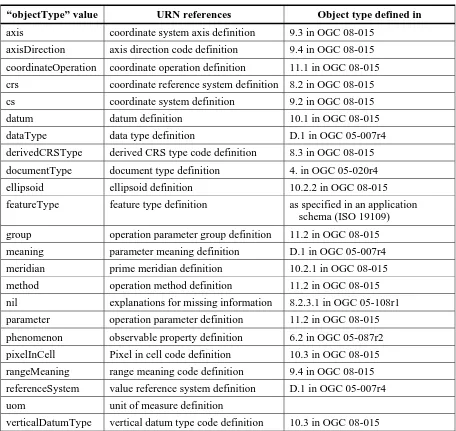
The required “objectType” part identifies the type of the referenced definition, and the allowed “objectType” values shall include those listed in Table 2.
Table 2 — “objectType” values for definitions in OGC URN namespace
“objectType” value URN references Object type defined in
axis coordinate system axis definition 9.3 in OGC 08-015
axisDirection axis direction code definition 9.4 in OGC 08-015
coordinateOperation coordinate operation definition 11.1 in OGC 08-015
crs coordinate reference system definition 8.2 in OGC 08-015
cs coordinate system definition 9.2 in OGC 08-015
datum datum definition 10.1 in OGC 08-015
dataType data type definition D.1 in OGC 05-007r4
derivedCRSType derived CRS type code definition 8.3 in OGC 08-015
documentType document type definition 4. in OGC 05-020r4
ellipsoid ellipsoid definition 10.2.2 in OGC 08-015
featureType feature type definition as specified in an application schema (ISO 19109)
group operation parameter group definition 11.2 in OGC 08-015
meaning parameter meaning definition D.1 in OGC 05-007r4
meridian prime meridian definition 10.2.1 in OGC 08-015
method operation method definition 11.2 in OGC 08-015
nil explanations for missing information 8.2.3.1 in OGC 05-108r1
parameter operation parameter definition 11.2 in OGC 08-015
phenomenon observable property definition 6.2 in OGC 05-087r2
pixelInCell Pixel in cell code definition 10.3 in OGC 08-015
rangeMeaning range meaning code definition 9.4 in OGC 08-015
referenceSystem value reference system definition D.1 in OGC 05-007r4
uom unit of measure definition
verticalDatumType vertical datum type code definition 10.3 in OGC 08-015
Specializing the above, the URN value for an anyURI that references one object in the European Petroleum Survey Group (EPSG) database should have the form:
urn:ogc:def:objectType:EPSG::code
In this case, the “authority” part of a URN shall be “EPSG”. The “code” part of a URN should be the EPSG “code” unique identifier of the referenced definition. Alternately, the “code” part of a URN can be the EPSG “name” unique identifier. It is recommended to omit the version number, as this is not required to identify a referenced record in the EPSG dataset and may even lead to confusion.
NOTE 2 The policy of the OGP Survey and Positioning Committee is to not delete any entities. However, if a record is found to be incorrect, that record is deprecated and replaced. When this is done, the deprecation field of the deprecated record is changed from "false" to "true". (In some implementations, "false" may be "0" or "no", and "true" may be "1" or "yes"). Deprecated records are also termed ‘invalid records’ When retrieving any geodetic parameters from the EPSG dataset a user therefore needs to verify whether the record(s) is / are valid or invalid. The user then has two options: (1) to follow the links provided and use the valid replacing record(s), a course typically followed when spatially referencing a new dataset, or (2) retrieve the invalid, deprecated record(s) in order to undo the effects of this error in an existing spatial dataset that had been spatially referenced using the incorrect records. Note that spatial referencing using (an) invalid EPSG entities will only generate errors if the data is subsequently subjected to coordinate conversions and/or transformations.
Example 1 The URN value for CRS 2984 is:
urn:ogc:def:crs:EPSG::2984.
However, this entity has been deprecated and has been replaced by CRS 3163:
urn:ogc:def:crs:EPSG::3163.
Example 1 The URN value for the “WGS 84 longitude-latitude” CRS specified in Subclause B.3 of WMS 1.3 (previously referenced as “CRS:84”) is:
urn:ogc:def:crs:OGC:1.3:CRS84
7.3 URN extensions for OGC
The following Subclauses 7.4 and 7.5 extend the normal uses of URNs to meet OGC needs, primarily for referencing Coordinate Reference Systems. One URN is required to uniquely and persistently identify one resource. Normally each URN value is opaque to URN users, and the sets of URNs and corresponding resources are both enumerable and peristent. The following URN extensions allow a non-enumerable (sometimes infinite) set of URNs to reference the corresponding non-enumerable set of (OGC) resources. The specific URNs and corresponding resources that are currently in use is expandable to other members of these non-enumerable sets.
NOTE 1 A non-enumerable set of URNs with the corresponding non-enumerable set of resources can be considered to be “virtual”, not being implemented until needed. When needed, a specific URN in this set can be automatically instantiated with its corresponding resource. Given a specific URN in such a non-enumerable (sometimes infinite) set of URNs, the corresponding specific resource in the corresponding non-enumerable set of resources can be automatically instantiated. Or given a specific resource in such a non-enumerable set of resources, the corresponding specific URN in the corresponding non-enumerable set of URNs can be automatically instantiated. Except for automatic implementation of the corresponding resource, these specific URNs can be used just like normal URNs, to uniquely, opaquely, and persistently identify the one corresponding resource. Only the appropriate URN resolution and registration service(s) need to know about the virtual nature of these sets of URNs with the corresponding set of resources. NOTE 2 An extended URN can also be considered to be “parameterized”, with parameter values in the URN value being used as specific values for the corresponding parameters in a corresponding
parameterized resource. Again, only the appropriate URN resolution and registration service(s) need to know about the parameterized nature of these sets of URNs with the corresponding set of resources. Each specific URN is opaque to URN users, and the associated specific resource is persistent (but not necessarily stored, or stored at fixed locations).
Each URN in such a non-enumerable set opaquely references the corresponding resource in such a non-enumerable set, where this correspondence is persistent (or fixed) although neither set is enumerable. That is, only the appropriate URN resolution and
creation/registration service(s) need to know that a non-enumerable set of URNs is referencing the corresponding non-enumerable set of resources. A URN resolution service can take any specific URN in such a non-enumerable set of URNs and
automatically instantiate the corresponding specific resource in the corresponding non-enumerable set of resources. A URN registration service can take any specific resource which falls in such a non-enumerable set of resources and automatically instantiate the corresponding specific URN in the corresponding non-enumerable set of URNs. Each specific URN is opaque to URN users, and the associated specific resource is persistent (but not necessarily stored, or stored at fixed locations).
7.4 URNs for not-completely-specified objects
A URN can also be used to denote a not-completely-specified object, which is specified without the values of a few identified parameters. In this case, the URN value includes the values for each identified parameter. To identify an object with two unspecified parameters, the URN shall have the form:
urn:ogc:def:objectType:authority:version:code:value1:value2
NOTE 1 Not-completely-specified objects are very useful when many similar objects are needed, especially when the possible values of the distinguishing parameters cannot be enumerated.
EXAMPLE 1 Subclause 6.7.3.4and Annex B of WMS 1.3.0 specify five not-completely-specified map projections, where the parameters specify the central meridian, etc.
EXAMPLE 2 Clause 7 of [OGC 05-096r1] specifies two not-completely-specified unrectified image CRSs, where the single parameter specifies the image identifier.
In this URN form, the values for the previously-identified parameters are added to the URN form for a single object, as specified above. The obvious variations on the URI form can be used when one or three parameters are unspecified. The object identified by the “authority”, “version”, and “code” must be completely specified with the exception of the values for a few clearly identified parameters. Whenever such a parameter value requires a unit of measure (uom), the uom for that parameter shall be specified by the referenced not-completely-specified object.
EXAMPLE 3 The URN value for the Auto Orthographic CRS 42003 specified in Subclauses 6.7.3.4 and B.9 of WMS 1.3.0 is:
urn:ogc:def:crs:OGC:1.3:AUTO42003:1:-100:45
NOTE 2 Additional examples of not-completely-specified objects are specified in Subclauses B.7, B.8, B.10, and B.11 of WMS 1.3.0, and in Subclauses 10.1 through 10, 3 of [OGC 05-096r1].
7.5 URNs for combined objects
7.5.1 Overview
In some cases, it is useful to reference two or more well-known objects that are combined, where the combination is specified at run time. Such combining of two or more well-known objects shall only be used when all of the following conditions are true:
a) The objects being combined are correct for the combination being formed, as these objects are specified in [OGC 08-015] for CRS-related objects.
b) This combination of objects is not an existing well-known object, such as specified in the EPSG database or a geodetic parameter dataset of an acknowledged alternative authority.
NOTE 1 If combining two or more well-known objects, please ask if this combination will be frequently used. If combining only EPSG codes because EPSG has not populated this combination, please send a request for this combination to the EPSG if this combination is likely to be frequently used. Similarly, if combining OGC codes, by themselves or with EPSG codes, please suggest that this combination be added to the OGC codes, if this combination is likely to be frequently used.
c) The objects being combined are all in the “ogc” URN namespace, preferably all defined by the same authority (e.g., EPSG or OGC).
NOTE 2 If objects specified by different authorities are combined, there is higher risk that these objects are not compatible. For example, some authorities might specify objects different from [OGC 08-015]. d) Using a URN for the combination is desirable, since it is not convenient to combine
these objects in an XML document based on GML, and then reference this document using a URL (as specified in Subclauses 10.3.1 and 10.3.2 of [OGC 06-121r3]).
A URN that identifies a definition that is itself defined by combining two or more objects shall be constructed by concatenating the URNs of the two individual objects into one URN, as follows:
urn:ogc:def:objectType,objectType:authority:version:code, objectType:authority:version:code
Similarly, an identifier can concatenate the URNs of the three individual objects, using the URN form:
urn:ogc:def:objectType,objectType:authority:version:code, objectType:authority:version:code,objectType:authority:version :code
NOTE 3 When URNs are concatenated like this, the combined object is implicitly defined, and is not assigned a single object “code”. That is, the defined object has no single code.
In a concatenated URN, the first “objectType” is the type of the combined object. Combined references in a URN can be used for defining several types of objects, as specified by specific Implementation Standards, including for:
a) Compound coordinate reference systems
b) Concatenated operations
c) Projected and derived coordinate reference systems
d) Combining a datum and a coordinate system into a coordinate reference system
e) Objects defined by specific Implementation Standards
The first four combinations listed above are described in the following subclauses.
7.5.2 URN combined references for compound coordinate reference systems
A URN reference to combined objects can be allowed for any compound coordinate reference system (CompoundCRS) that combines two or three well-known CRSs. In this case, the URN shall concatenate the URNs of the two or three individual well-known CRSs. This combining is allowed only when all the conditions specified in Subclause 7.3.1 are met.
The URNs of the individual well-known CRSs shall be listed in the same order in which the individual coordinate tuples are combined to form the CompoundCRS
coordinate tuple. All the “objectType” values shall be “crs”.
EXAMPLE The URN value for combining the CRSs: EPSG 4269 (NAD83) and EPSG 5713 (Canadian Geodetic Vertical Datum of 1928 height is:
urn:ogc:def:crs,crs:EPSG::4269,crs:EPSG::5713
7.5.3 URN combined references for concatenated operations
A URN reference to combined objects can be allowed for any concatenated coordinate operation (ConcatenatedOperation) that combines two or more well-known coordinate operations. In this case, the URN shall concatenate the URNs of the two or more well-known coordinate operations. This combining is allowed only when all the conditions specified in Subclause 7.3.1 are met.
NOTE 1 In particular, the coordinate operations concatenated must meet the stated constraint: The sequence of operations is constrained by the requirement that the source coordinate reference system of step (n+1) must be the same as the target coordinate reference system of step (n). The source coordinate reference system of the first step and the target coordinate reference system of the last step are the source and target coordinate reference system associated with the concatenated operation.
NOTE 2 In a well-known dataset, a CoordinateOperation may be registered only in one direction, with the reverse operation being implied. This means that the roles of source and target CRS may have to be swapped if an implied-reverse CoordinateOperation is included in a ConcatenatedOperation. In this case, the swapped source and target CRS shall satisfy the above constraint.
The URNs of the individual coordinate operations shall be concatenated in the order of coordinate operation application. The “objectType” values shall all be
“coordinateOperation”.
EXAMPLE The URN value for combining the EPSG XXXX and EPSG YYYY coordinate operations is:
urn:ogc:def:coordinateOperation,coordinateOperation:EPSG::XXXX,coord inateOperation:EPSG::YYYY
7.5.4 URN combined references for projected or derived CRSs
A URN reference to combined objects can be allowed for any projected coordinate reference system (ProjectedCRS) that combines a well-known GeographicCRS and a well-known (defined by) Conversion. In this case, the URN shall concatenate the URNs of the one well-known CRS, one well-known Conversion, and one well-known
CartesianCS. This combining is allowed only when all the conditions specified in Subclause 7.3.1 are met.
Similarly, a URN reference to combined objects can be allowed for any derived coordinate reference system (DerivedCRS) that combines a well-known base CRS, a well-known CoordinateSystem, and a well-known (defined by) Conversion.
The URNs of the individual components of the projected or derived CRS shall be listed in the order of GeographicCRS, CS, and then Conversion. The four “objectType” values shall be “crs”, “crs”, “cs”, and “coordinateOperation”.
EXAMPLE The URN value for combining the EPSG XXXX CRS, EPSG YYYY CS, and EPSG ZZZZ Conversion to define a custom projected or derived CRS is:
urn:ogc:def:crs,crs:EPSG::XXXX,cs:EPSG::YYYY,coordinateOperation:EPS G::ZZZZ
7.5.5 URN combined references for datum and coordinate system
A URN reference to combined objects can be allowed for a coordinate reference system that combines a well-known datum with a well-known coordinate system. In this case, the URN shall concatenate the URNs of one well-known datum and one well-known coordinate system. This combining is allowed only when all the conditions specified in Subclause 7.3.1 are met.
The URNs of the individual components shall be listed in the order of datum and then coordinate system. The three “objectType” values shall be “crs”, “datum” and “cs”.
EXAMPLE The URN value for combining the EPSG XXXX datum and EPSG YYYY coordinate system to define a custom CRS is:
urn:ogc:def:crs,datum:EPSG::XXXX,cs:EPSG::YYYY
8 URN values for definitions and concepts in ogc namespace
8.1 Introduction
This clause provides the normative specification and URNs for some specific object definitions defined by the OGC. Additional definitions in the “ogc” URN namespace will
be specified in other OGC documents. For example, more URNs are specified in Subclause 7.1 of the GML grid CRSs profile [OGC 05-096r1].
NOTE Many examples of “ogc” URN use for object definitions are contained in the GML examples in Annex A of this document, in Clause 7 of [OGC 05-096r1], and in Clause 6 of [OGC 05-095r1].
8.2 CRS definitions
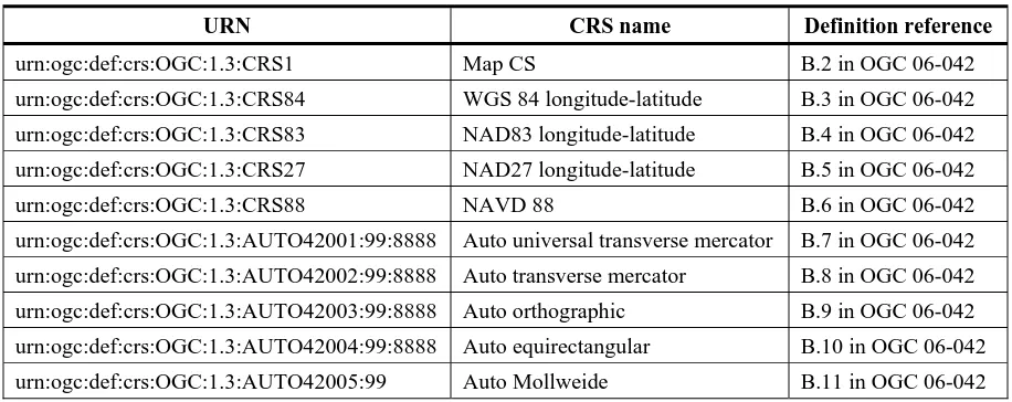
The definitions of Coordinate Reference Systems (CRSs) defined by the OGC shall use the URNs listed in Table 3. The URN parts shown as “99” ands “8888” represent numbers that shall be substituted for the specified parameter values. All of these CRSs are defined in Annex B of WMS 1.3 [OGC 06-042].
Table 3 — URNs for CRSs defined by OGC
URN CRS name Definition reference
urn:ogc:def:crs:OGC:1.3:CRS1 Map CS B.2 in OGC 06-042
urn:ogc:def:crs:OGC:1.3:CRS84 WGS 84 longitude-latitude B.3 in OGC 06-042 urn:ogc:def:crs:OGC:1.3:CRS83 NAD83 longitude-latitude B.4 in OGC 06-042 urn:ogc:def:crs:OGC:1.3:CRS27 NAD27 longitude-latitude B.5 in OGC 06-042
urn:ogc:def:crs:OGC:1.3:CRS88 NAVD 88 B.6 in OGC 06-042
urn:ogc:def:crs:OGC:1.3:AUTO42001:99:8888 Auto universal transverse mercator B.7 in OGC 06-042 urn:ogc:def:crs:OGC:1.3:AUTO42002:99:8888 Auto transverse mercator B.8 in OGC 06-042 urn:ogc:def:crs:OGC:1.3:AUTO42003:99:8888 Auto orthographic B.9 in OGC 06-042 urn:ogc:def:crs:OGC:1.3:AUTO42004:99:8888 Auto equirectangular B.10 in OGC 06-042 urn:ogc:def:crs:OGC:1.3:AUTO42005:99 Auto Mollweide B.11 in OGC 06-042
8.3 CRS code list values definitions
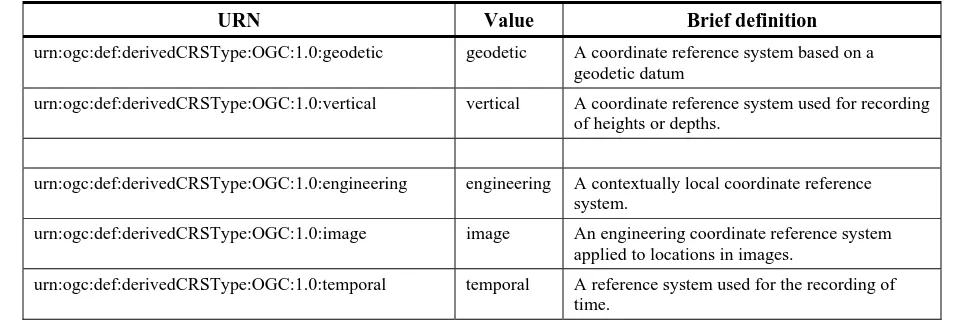
The definitions of the standard values for the five CodeList stereotyped classes specified in Tables 9, 31, 32, 37, and 39 of OGC Abstract Specification Topic 2 [OGC 08-015] shall use the URNs listed in Tables 2 through 6. The definitions of these values shall be as specified in the XML documents in Subclauses A.2 through A.6.
Table 4 — URNs for derivedCRSType values
URN Value Brief definition
urn:ogc:def:derivedCRSType:OGC:1.0:geodetic geodetic A coordinate reference system based on a
geodetic datum
urn:ogc:def:derivedCRSType:OGC:1.0:vertical vertical A coordinate reference system used for recording
of heights or depths.
urn:ogc:def:derivedCRSType:OGC:1.0:engineering engineering A contextually local coordinate reference
system.
urn:ogc:def:derivedCRSType:OGC:1.0:image image An engineering coordinate reference system
applied to locations in images.
urn:ogc:def:derivedCRSType:OGC:1.0:temporal temporal A reference system used for the recording of
time.
Table 5 — URNs for verticalDatumType values
URN Value Brief definition
urn:ogc:def:verticalDatumType:OGC:1.0:geoidal geoidal Zero value of vertical axis approximates a
constant potential surface, usually the geoid.
urn:ogc:def:verticalDatumType:OGC:1.0:depth depth Zero value of vertical axis has meaning for
purpose which measurements are used for
urn:ogc:def:verticalDatumType:OGC:1.0:barometric barometric Atmospheric pressure is basis for the
definition of origin of vertical axis
urn:ogc:def:verticalDatumType:OGC:1.0:otherSurface otherSurface Other variations to above three vertical datum types.
NOTE The verticalDatumType existed in the previous version of OGC Abstract Specification Topic 2 [OGC 04-046r3], but has been removed in the new version [OGC 08-015]. The verticalDatumType is thus included in GML 3.1.1, but not in GML 3.2 [OGC 05-108r1].
Table 6 — URNs for pixelInCell values
URN Value Definition
urn:ogc:def:pixelInCell:OGC:1.0:cellCenter cellCenter The origin of the image coordinate system is at the centre of a grid cell or image pixel. urn:ogc:def:pixelInCell:OGC:1.0:cellCorner cellCorner The origin of the image coordinate system is
at the corner of a grid cell, or half-way between the centres of adjacent image pixels. Table 7 — URNs for rangeMeaning values
URN Value Brief definition
urn:ogc:def:rangeMeaning:OGC:1.0:exact exact Any value between and including minimumValue
and maximiumValue is valid.
urn:ogc:def:rangeMeaning:OGC:1.0:wraparound wraparound The axis is continuous with values wrapping
around at the minimumValue and maximumValue.
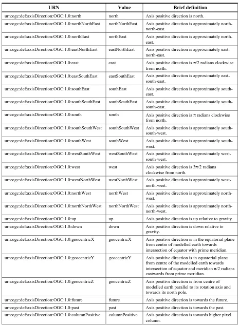
Table 8 — URNs for axisDirection values
URN Value Brief definition
urn:ogc:def:axisDirection:OGC:1.0:north north Axis positive direction is north.
urn:ogc:def:axisDirection:OGC:1.0:northNorthEast northNorthEast Axis positive direction is approximately north-north-east.
urn:ogc:def:axisDirection:OGC:1.0:northEast northEast Axis positive direction is approximately north-east.
urn:ogc:def:axisDirection:OGC:1.0:eastNorthEast eastNorthEast Axis positive direction is approximately east-north-east.
urn:ogc:def:axisDirection:OGC:1.0:east east Axis positive direction is π/2 radians clockwise
from north.
urn:ogc:def:axisDirection:OGC:1.0:eastSouthEast eastSouthEast Axis positive direction is approximately east-south-east.
urn:ogc:def:axisDirection:OGC:1.0:southEast southEast Axis positive direction is approximately south-east.
urn:ogc:def:axisDirection:OGC:1.0:southSouthEast southSouthEast Axis positive direction is approximately south-south-east.
urn:ogc:def:axisDirection:OGC:1.0:south south Axis positive direction is π radians clockwise
from north.
urn:ogc:def:axisDirection:OGC:1.0:southSouthWest southSouthWest Axis positive direction is approximately south-south-west.
urn:ogc:def:axisDirection:OGC:1.0:southWest southWest Axis positive direction is approximately south-west.
urn:ogc:def:axisDirection:OGC:1.0:westSouthWest westSouthWest Axis positive direction is approximately west-south-west.
urn:ogc:def:axisDirection:OGC:1.0:west west Axis positive direction is 3π/2 radians
clockwise from north.
urn:ogc:def:axisDirection:OGC:1.0:westNorthWest westNorthWest Axis positive direction is approximately west-north-west.
urn:ogc:def:axisDirection:OGC:1.0:northWest northWest Axis positive direction is approximately north-west.
urn:ogc:def:axisDirection:OGC:1.0:northNorthWest northNorthWest Axis positive direction is approximately north-north-west.
urn:ogc:def:axisDirection:OGC:1.0:up up Axis positive direction is up relative to gravity.
urn:ogc:def:axisDirection:OGC:1.0:down down Axis positive direction is down relative to gravity.
urn:ogc:def:axisDirection:OGC:1.0:geocentricX geocentricX Axis positive direction is in the equatorial plane from centre of modelled earth towards
intersection of equator with prime meridian.
urn:ogc:def:axisDirection:OGC:1.0:geocentricY geocentricY Axis positive direction is in equatorial plane from centre of the modelled earth towards intersection of equator and meridian π/2 radians eastwards from prime meridian.
urn:ogc:def:axisDirection:OGC:1.0:geocentricZ geocentricZ Axis positive direction is from centre of modelled earth parallel to its rotation axis and towards its north pole.
urn:ogc:def:axisDirection:OGC:1.0:future future Axis positive direction is towards the future.
urn:ogc:def:axisDirection:OGC:1.0:past past Axis positive direction is towards the past.
urn:ogc:def:axisDirection:OGC:1.0:columnPositive columnPositive Axis positive direction is towards higher pixel column.
URN Value Brief definition
urn:ogc:def:axisDirection:OGC:1.0:columnNegative columnNegative Axis positive direction is towards lower pixel column.
urn:ogc:def:axisDirection:OGC:1.0:rowPositive rowPositive Axis positive direction is towards higher pixel row.
urn:ogc:def:axisDirection:OGC:1.0:rowNegative rowNegative Axis positive direction is towards lower pixel row.
urn:ogc:def:axisDirection:OGC:1.0:displayRight displayRight Axis positive direction is right in display.
urn:ogc:def:axisDirection:OGC:1.0:displayLeft displayLeft Axis positive direction is left in display.
urn:ogc:def:axisDirection:OGC:1.0:displayUp displayUp Axis positive direction is towards top of approximately vertical display surface.
urn:ogc:def:axisDirection:OGC:1.0:displayDown displayDown Axis positive direction is towards bottom of approximately vertical display surface.
NOTE There is some overlap with the axis directions defined in the EPSG dataset, but this is not perceived to create any problems for users.
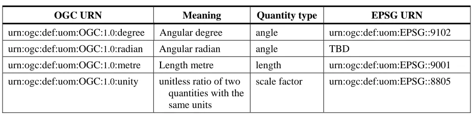
8.4 Unit-of-measure (uom) definitions
The definitions of some units-of-measure which are defined by the OGC shall use the URNs listed in Table 9. The definitions of these units shall be as specified in the XML document in Subclause A.7. Most of these units are also specified by the EPSG, as listed.
Table 9 — URNs for units-of-measure
OGC URN Meaning Quantity type EPSG URN
urn:ogc:def:uom:OGC:1.0:degree Angular degree angle urn:ogc:def:uom:EPSG::9102 urn:ogc:def:uom:OGC:1.0:radian Angular radian angle TBD
urn:ogc:def:uom:OGC:1.0:metre Length metre length urn:ogc:def:uom:EPSG::9001 urn:ogc:def:uom:OGC:1.0:unity unitless ratio of two
quantities with the same units
scale factor urn:ogc:def:uom:EPSG::8805
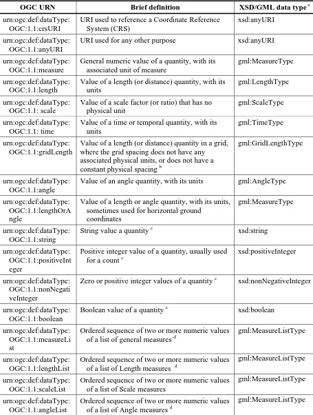
8.5 Data type definitions
URNs are useful to identify data types in multiple OGC Implementation Standards. These uses include in the ows:DataType (metadata) element in the ows:DomainType in the new version of the OWS Common Implementation Standard [OGC 06-121r3]. The OGC-specified URNs that can be used for identifying data types (expected to be used in multiple OGC Implementation Standards) shall include those listed in Table 10. The left column lists each URN specified here, and the centre column lists the definition which shall be used for that URN.
Use of these URNs is not limited to data encoded in XML, or even to use of these URNs in XML-encoded documents. When data is encoded in XML, the right column in this table lists an XML Schema (XSD) or Geometry Markup Language (GML) version 3.1.1 identifier that can be used to encode that data type. More complete definitions of some of these data types are specified in the XML document in Subclause A.8.
Table 10 — URNs for data types
OGC URN Brief definition XSD/GML data type a
urn:ogc:def:dataType: OGC:1.1:crsURI
URI used to reference a Coordinate Reference System (CRS)
xsd:anyURI
urn:ogc:def:dataType: OGC:1.1:anyURI
URI used for any other purpose xsd:anyURI
urn:ogc:def:dataType: OGC:1.1:measure
General numeric value of a quantity, with its associated unit of measure
gml:MeasureType
urn:ogc:def:dataType: OGC:1.1:length
Value of a length (or distance) quantity, with its units
gml:LengthType
urn:ogc:def:dataType: OGC:1.1: scale
Value of a scale factor (or ratio) that has no physical unit
gml:ScaleType
urn:ogc:def:dataType: OGC:1.1: time
Value of a time or temporal quantity, with its units
gml:TimeType
urn:ogc:def:dataType: OGC:1.1:gridLength
Value of a length (or distance) quantity in a grid, where the grid spacing does not have any associated physical units, or does not have a constant physical spacing b
gml:GridLengthType
urn:ogc:def:dataType: OGC:1.1:angle
Value of an angle quantity, with its units gml:AngleType
urn:ogc:def:dataType: OGC:1.1:lengthOrA ngle
Value of a length or angle quantity, with its units, sometimes used for horizontal ground
coordinates
gml:MeasureType
urn:ogc:def:dataType: OGC:1.1:string
String value a quantityc xsd:string
urn:ogc:def:dataType: OGC:1.1:positiveInt eger
Positive integer value of a quantity, usually used for a count c
xsd:positiveInteger
urn:ogc:def:dataType: OGC:1.1:nonNegati veInteger
Zero or positive integer values of a quantityc xsd:nonNegativeInteger
urn:ogc:def:dataType: OGC:1.1:boolean
Boolean value of a quantityc xsd:boolean
urn:ogc:def:dataType: OGC:1.1:measureLi st
Ordered sequence of two or more numeric values of a list of general measures d
gml:MeasureListType
urn:ogc:def:dataType: OGC:1.1:lengthList
Ordered sequence of two or more numeric values of a list of Length measures d
gml:MeasureListType
urn:ogc:def:dataType: OGC:1.1:scaleList
Ordered sequence of two or more numeric values of a list of Scale measures
gml:MeasureListType
urn:ogc:def:dataType: OGC:1.1:angleList
Ordered sequence of two or more numeric values of a list of Angle measures d
gml:MeasureListType
OGC URN Brief definition XSD/GML data type a
urn:ogc:def:dataType: OGC:1.1:timeList
Ordered sequence of two or more numeric values of a list of Time measures d
gml:MeasureListType
urn:ogc:def:dataType: OGC:1.1:gridLength List
Ordered sequence of two or more numeric values of a list of Grid Length measures d
gml:MeasureListType
urn:ogc:def:dataType: OGC:1.1:integerList
Ordered sequence of two or more integer values of a list, usually used for counts
gml:integerList
urn:ogc:def:dataType: OGC:1.1:positiveInt egerList
Ordered sequence of two or more positive integer values of a list, usually used for counts e
gml:integerList
urn:ogc:def:dataType: OGC:1.1:valueFile
URN reference to file or part of a file containing one or more parameter values, each numeric value with its associated unit of measure
gml:valueFile
urn:ogc:def:dataType: OGC:1.1:anyCRS
Definition of any Coordinate Reference System Any concrete element in substitution group headed by
gml:AbstractCoordin ateReferenceSystem
a This data type is stated as a qualified name (QName). The two namespaces used here are: xmlns:gml=”http://www.opengis.net/gml”
xmlns:xsd=”http://www.w3.org/2001/XMLSchema”
b This grid length will often be used in a digital image grid, where the base units are likely to be pixel spacings.
c Does not have an associated unit of measure.
d Each value shall have the same associated unit of measure. An element of this type contains a space-separated list of double values with one associated unit of measure.
e An element of this type contains a space-separated list of integer values, without an associated unit of measure.
Annex A
(normative)
GML dictionaries of OGC definitions
A.1 Introduction
This annex provides XML documents that specify the definitions of some of the objects assigned “ogc” URN values in Clause 8. Except for units-of-measure, these definitions are encoded in XML using the GML 3.1.1 simple dictionary profile [OGC 05-099r2]. The unitsDictionary is encoded in XML using coordinateReferenceSystems.xsd from GML 3.1.1.
NOTE All of these definitions also could be encoded using the gml:Dictionary element from
dictionary.xsd in GML 3.1.1. The XML documents could be identical except for referencing dictionary.xsd in GML 3.1.1 instead of referencing the GML 3.1.1 simple dictionary profile.
These XML-encoded document files may be bundled in a zip file with this document. These XML files are also posted online at the URL
http://schemas.opengeospatial.net/definitions/, in a lower level directory used for this Version of this document. In the event of a discrepancy between the bundled and online versions of these XML files, the online files shall be considered authoritative.
A server may reference an exact copy of these documents located elsewhere, as long as they are readily accessible by clients. For example, it may be desirable to place the referenced documents on the same network server as an OWS instance, since that decreases the number of points of possible network failure. Such local copies should be organized into directories similar to http://schemas.opengeospatial.net/. The server owner shall insure that any such local copies are kept up-to-date with respect to the authoritative files at http://schemas.opengeospatial.net/.
A.2 Definitions of derivedCRSType values
The definitions of the derivedCRSType standard values used in defining DerivedCRSs shall be the same as can be XML encoded in the GML 3.1.1 simple dictionary profile:
<?xml version="1.0" encoding="UTF-8"?>
<Dictionary xmlns="http://www.opengis.net/gml" xmlns:gml="http://www.opengis.net/gml"
xmlns:xlink="http://www.w3.org/1999/xlink"
xmlns:xsi="http://www.w3.org/2001/XMLSchema-instance" xsi:schemaLocation="http://www.opengis.net/gml
gml\3.1.1\Profiles\SimpleDictionary\1.0.0\gmlSimpleDictionaryProfile.xs d"
gml:id="DerivedCRStypeDictionary">
<!-- Primary editor: Arliss Whiteside. Last updated 2006-02-13 --> <name>Derived CRS type standard values</name>
<!-- ===================================================== --> <dictionaryEntry>
<Definition gml:id="geodetic">
<description>A coordinate reference system based on a geodetic datum; provides an accurate representation of the geometry of
geographic features for a large portion of the earth's surface. </description>
<name
codeSpace="urn:ogc:tc:urn:doc:bpp:06-023">">urn:ogc:def:derivedCRStype:OGC:1.0:geographic</name> </Definition>
</dictionaryEntry> <dictionaryEntry>
<Definition gml:id="vertical">
<description>A coordinate reference system used for recording of heights or depths. Vertical CRSs make use of the direction of
gravity to define the concept of height or depth, but the relationship with gravity may not be straightforward. </description>
<name codeSpace="urn:ogc:tc:urn:doc:bpp:06-023">urn:ogc:def:derivedCRStype:OGC:1.0:vertical</name> </Definition>
</dictionaryEntry>
<dictionaryEntry>
<Definition gml:id="engineering">
<description>A contextually local coordinate reference system; which can be divided into two broad categories:
- earth-fixed systems applied to engineering activities on or near the surface of the earth;
- CRSs on moving platforms such as road vehicles, vessels, aircraft, or spacecraft. </description>
<name
codeSpace="urn:ogc:def:derivedCRStype:OGC:OGC:1.0:">engineering</name> </Definition>
</dictionaryEntry> <dictionaryEntry>
<Definition gml:id="image">
<description>A derived CRS used like an engineering coordinate reference system applied to locations in images. </description>
<name codeSpace="urn:ogc:tc:urn:doc:bpp:06-023">urn:ogc:def:derivedCRStype:OGC:1.0:image</name> </Definition>
</dictionaryEntry> <dictionaryEntry>
<Definition gml:id="temporal">
<description>A reference system used for the recording of time. </description>
<name codeSpace="urn:ogc:tc:urn:doc:bpp:06-023">urn:ogc:def:derivedCRStype:OGC:1.0:temporal</name> </Definition>
</dictionaryEntry> </Dictionary>
A.3 Definitions of verticalDatumType values
The definitions of the verticalDatumType standard values used in defining
VerticalDatums shall be the same as can be XML encoded in the GML 3.1.1 simple dictionary profile:
<?xml version="1.0" encoding="UTF-8"?>
<Dictionary xmlns="http://www.opengis.net/gml" xmlns:gml="http://www.opengis.net/gml"
<!-- Primary editor: Arliss Whiteside. Last updated 2006-02-13 --> <name>Vertical Datum Type standard values</name>
<!-- ===================================================== --> <dictionaryEntry>
<Definition gml:id="geoidal">
<description>The zero value of the associated vertical
coordinate system axis is defined to approximate a constant potential surface, usually the geoid. Such a reference surface is usually
determined by a national or scientific authority, and is then a well-known, named datum. </description>
<name codeSpace="urn:ogc:tc:urn:docbpp:06-023">urn:ogc:def:pixelInCell:OGC:1.0:geoidal</name> </Definition>
</dictionaryEntry> <dictionaryEntry>
<!-- ===================================================== --> <Definition gml:id="depth">
<description>The zero point of the vertical axis is defined by a surface that has meaning for the purpose which the associated
vertical measurements are used for. For hydrographic charts, this is often a predicted nominal sea surface (i.e., without waves or other wind and current effects) that occurs at low tide. </description> <name
codeSpace="urn:ogc:tc:urn:docbpp:06-023">urn:ogc:def:pixelInCell:OGC:1.0:depth</name> </Definition>
</dictionaryEntry>
<!-- ===================================================== --> <dictionaryEntry>
<Definition gml:id="barometric">
<description>Atmospheric pressure is the basis for the
definition of the origin of the associated vertical coordinate system axis. </description>
<name codeSpace="urn:ogc:tc:urn:docbpp:06-023">urn:ogc:def:pixelInCell:OGC:1.0:barometric</name> </Definition>
</dictionaryEntry> <dictionaryEntry>
<!-- ===================================================== --> <Definition gml:id="otherSurface">
<description>In some cases, e.g. oil exploration and production, a geological feature, such as the top or bottom of a
geologically identifiable and meaningful subsurface layer, is used as a