Publication Date: 2015-02-02
Approval Date: 2014-09-30
Submission Date: 2014-08-28
Reference number of this document: OGC 14-079r1
Reference URL for this document: http://www.opengeospatial.net/doc/PER/usgs-interop-assessment
Category: Public Engineering Report
Editor: Ingo Simonis
USGS OGC
®Interoperability Assessment Report
Copyright © 2015 Open Geospatial Consortium.
To obtain additional rights of use, visit http://www.opengeospatial.org/legal/.
This document is not an OGC Standard. This document is an OGC Public
Engineering Report created as a deliverable in an OGC Interoperability Initiative and is not an official position of the OGC membership. It is distributed for review and comment. It is subject to change without notice and may not be referred to as an OGC Standard. Further, any OGC Engineering Report should not be referenced as required or mandatory technology in procurements.
Document type: OGC® Public Engineering Report Document subtype: NA
Abstract
The USGS Interoperability assessment was conducted under the OGC Interoperability Program with the goal to better understand how USGS customers make use of OGC compliant Web services operated by USGS. For this assessment, USGS customers have been invited to share their experiences and to describe their use cases and experiences made with USGS data services and products. From those descriptions, recommendations have been derived that help USGS to better understand their user community and
optimize their service offerings.
Keywords
License Agreement
Permission is hereby granted by the Open Geospatial Consortium, ("Licensor"), free of charge and subject to the terms set forth below, to any person obtaining a copy of this Intellectual Property and any associated documentation, to deal in the Intellectual Property without restriction (except as set forth below), including without limitation the rights to implement, use, copy, modify, merge, publish, distribute, and/or sublicense copies of the Intellectual Property, and to permit persons to whom the Intellectual Property is furnished to do so, provided that all copyright notices on the intellectual property are retained intact and that each person to whom the Intellectual Property is furnished agrees to the terms of this Agreement.
If you modify the Intellectual Property, all copies of the modified Intellectual Property must include, in addition to the above copyright notice, a notice that the Intellectual Property includes modifications that have not been approved or adopted by LICENSOR. THIS LICENSE IS A COPYRIGHT LICENSE ONLY, AND DOES NOT CONVEY ANY RIGHTS UNDER ANY PATENTS THAT MAY BE IN FORCE ANYWHERE IN THE WORLD.
THE INTELLECTUAL PROPERTY IS PROVIDED "AS IS", WITHOUT WARRANTY OF ANY KIND, EXPRESS OR IMPLIED, INCLUDING BUT NOT LIMITED TO THE WARRANTIES OF MERCHANTABILITY, FITNESS FOR A PARTICULAR PURPOSE, AND NONINFRINGEMENT OF THIRD PARTY RIGHTS. THE COPYRIGHT HOLDER OR HOLDERS INCLUDED IN THIS NOTICE DO NOT WARRANT THAT THE FUNCTIONS CONTAINED IN THE INTELLECTUAL PROPERTY WILL MEET YOUR REQUIREMENTS OR THAT THE OPERATION OF THE INTELLECTUAL PROPERTY WILL BE
UNINTERRUPTED OR ERROR FREE. ANY USE OF THE INTELLECTUAL PROPERTY SHALL BE MADE ENTIRELY AT THE USER’S OWN RISK. IN NO EVENT SHALL THE COPYRIGHT HOLDER OR ANY CONTRIBUTOR OF
INTELLECTUAL PROPERTY RIGHTS TO THE INTELLECTUAL PROPERTY BE LIABLE FOR ANY CLAIM, OR ANY DIRECT, SPECIAL, INDIRECT OR CONSEQUENTIAL DAMAGES, OR ANY DAMAGES WHATSOEVER RESULTING FROM ANY ALLEGED INFRINGEMENT OR ANY LOSS OF USE, DATA OR PROFITS, WHETHER IN AN ACTION OF CONTRACT, NEGLIGENCE OR UNDER ANY OTHER LEGAL THEORY, ARISING OUT OF OR IN CONNECTION WITH THE IMPLEMENTATION, USE, COMMERCIALIZATION OR PERFORMANCE OF THIS INTELLECTUAL PROPERTY. This license is effective until terminated. You may terminate it at any time by destroying the Intellectual Property together with all copies in any form. The license will also terminate if you fail to comply with any term or condition of this Agreement. Except as provided in the following sentence, no such termination of this license shall require the termination of any third party end-user sublicense to the Intellectual Property which is in force as of the date of notice of such termination. In addition, should the Intellectual Property, or the operation of the Intellectual Property, infringe, or in LICENSOR’s sole opinion be likely to infringe, any patent, copyright, trademark or other right of a third party, you agree that LICENSOR, in its sole discretion, may terminate this license without any compensation or liability to you, your licensees or any other party. You agree upon termination of any kind to destroy or cause to be destroyed the Intellectual Property together with all copies in any form, whether held by you or by any third party. Except as contained in this notice, the name of LICENSOR or of any other holder of a copyright in all or part of the Intellectual Property shall not be used in advertising or otherwise to promote the sale, use or other dealings in this Intellectual Property without prior written authorization of LICENSOR or such copyright holder. LICENSOR is and shall at all times be the sole entity that may authorize you or any third party to use certification marks, trademarks or other special designations to indicate compliance with any LICENSOR standards or specifications.
This Agreement is governed by the laws of the Commonwealth of Massachusetts. The application to this Agreement of the United Nations Convention on Contracts for the International Sale of Goods is hereby expressly excluded. In the event any provision of this Agreement shall be deemed unenforceable, void or invalid, such provision shall be modified so as to make it valid and enforceable, and as so modified the entire Agreement shall remain in full force and effect. No decision, action or inaction by LICENSOR shall be construed to be a waiver of any rights or remedies available to it.
Contents
Page1 Introduction ... 1
1.1 Scope ... 1
1.2 Document contributor contact points ... 2
1.3 Revision history ... Error! Bookmark not defined. 1.4 Future work ... 2
5.2 Applied Modifications to Test Scripts ... 6
5.3 Services and Test Results ... 6
5.4 Remaining Test Scripts Modification Strategy ... 8
6 Catalog Service 3.0 Executable Test Suite ... 9
7 Use Cases and Communities of Use ... 10
7.1 Call for Participation ... 10
7.2 California Earthquake Clearinghouse ... 12
7.2.1 Use Case ... 12
7.6 Oregon Coastal Management Program ... 23
7.6.1 Use Case ... 23
7.6.2 Data & Services ... 25
7.7 NGA use of USGS Services ... 25
7.7.1 Use Case ... 25
7.7.2 Data & Services ... 26
7.7.3 Recommendations ... 27
8 General Recommendations ... 28
Figures
Page Figure 1: Catalog dependencies ... 10Figure 2: CFP Responses ... 11
Figure 3: Local to federal communication and support chains ... 12
Figure 4: CalEOS technology decisions ... 13
Figure 5: Technology relationships in case of disaster management operations ... 15
Figure 6: Aggregated data intended to be served as a service by DOTD ... 17
Figure 7: Troup County client to visualize elevation data using USGS NED ... 22
Figure 8: West Coast Ocean Data Portal (http://portal.westcoastoceans.org) ... 24
Figure 9: NGA GEOINT App Store (http://apps.nga.mil) ... 26
Copyright © 2015 Open Geospatial Consortium. 1
USGS OGC
®Interoperability Assessment Report
1 Introduction
1.1 Scope
The USGS Interoperability assessment was conducted under the OGC Interoperability Program. The goal of this assessment is to better understand how USGS customers make use of OGC Web services operated by USGS. Currently, USGS data services get over 1 million hits per day. USGS data are being used by a range of communities at the state, county, city, and other levels for a variety of purposes, such as science and decision-support. The assessment was conducted under the auspices of the National Geospatial Program (NGP). The vision of the NGP is to "satisfy the needs of users by providing geospatial products and services that users incorporate into their decision-making and operational activities." To support that vision, the User Engagement (UE) team acts as the NGP technical outreach group and performs the following activities:
Systematically gathers, analyzes and reports user requirements for “The National Map” (TNM) products and services from high priority communities of use Helps users exploit TNM products and services to meet their core mission
requirements
Develops and maintains relationships with users and sources of authoritative data sources
Communicates NGP program activities and directions to the broad audience of government, commercial, academic and public professionals.
OGC helped the USGS assess whether OGC standards as implemented in USGS servers are meeting users requirements. The following main tasks were performed in this project:
Compliance Testing: USGS provided 15 OGC standards based servers that were tested thoroughly for compliance. OGC enabled services tested included: OGC Web Feature Service (WFS), Web Coverage Service (WCS), and Sensor Observation Service (SOS)
(Webinar). In the exercise the Webinar was used to capture the use cases, tools and overall experience of communities interacting with USGS data.
Developing executable test suites for OGC Catalogue (CAT) 3.0: At the time of this project the Catalog/CSW 3.0 standard was in process of approval. The test was developed for the basic conformance classes.
1.2 Document contributor contact points
All questions regarding this document should be directed to the editor or the contributors:
Name Organization
Ingo Simonis OGC
Luis Bermudez OGC
1.3 Future work
Future work is envisioned in the context of service testing. This project informed the OGC process, resulting in modifications to the initial CITE TEAM Engine test scripts for WFS (version 1.1). To make those tests fully independent of the data set supported by the service, further modifications are necessary.
1.4 Notice to all
Attention is drawn to the possibility that some of the elements of this document may be the subject of patent rights. The Open Geospatial Consortium shall not be held
responsible for identifying any or all such patent rights.
Recipients of this document are requested to submit, with their comments, notification of any relevant patent claims or other intellectual property rights of which they may be aware that might be infringed by any implementation of the standard set forth in this document, and to provide supporting documentation.
2 References
The following documents are referenced in this document. For dated references, subsequent amendments to, or revisions of, any of these publications do not apply. For undated references, the latest edition of the normative document referred to applies.
Service compliance testing report version 1 and version 2
3 Conventions
3.1 Abbreviated terms
API Application Programming Interface
CalEOS California Governor's Office of Emergency Services DHS Department of Homeland Security
DoD US Department of Defense
EDXML Emergency Data Exchange Language EPA Environmental Protection Agency GeoMAC Geospatial Multi-Agency Coordination HDDS Hazards Data Distribution System KML Keyhole Markup Language LIDAR Light detection and ranging NED National Elevation Dataset NHD National Hydrography Dataset NHSS Natural Hazard Support System NIEM National Information Exchange Model O&M Observation and Measurement
SOS Sensor Observation Service
UICDS Unified Incident Command and Decision Support USGS US Geological Survey
WFS Web Feature Service WMS Web Map Service
4 Summary
USGS data services are an important resource for different communities, including organizations at the state, county, and city level. The data are used for variety of purposes, such as scientific research, planning, and decision-support. OGC assisted the USGS by running an interoperability assessment initiative with the goal of determining whether OGC standards as implemented in USGS servers were meeting users
requirements. Three activities were part of this project:
Compliance Testing: A total number of 15 Web services were tested using the CITE TEAM engine as well as additional manual tests. The goal was to evaluate the compliance of WFS, WCS, and SOS service instances. The current
compliance test suite requires some of these services (WFS 1.0 and WFS 1.1) to serve a specific test data set. As it was not possible to load this test data set on the production level service instances, the compliance tests were adapted to work with generic services. The type and nature of the tests have been conserved. The modified tests and test results are described in chapter five. Future work is envisioned to make the changes official.
Developing executable test suites for CAT 3.0: At the time of this project the OGC Catalog/CSW 3.0 candidate standard was in the approval process. A test was developed for the basic conformance class and published in GitHub. This test should serve as a baseline that can be advanced by other test developers.More details can be found in chapter six.
Development of use cases and investigation of usability with Communities of
Use: Over the course of three webinars, experiences and use case descriptions from six participants were recorded and assessed. This process yielded a broad range of use cases. Some organizations used the offered services “as is”. Other organizations integrated data and services into their own workflows, developing complex processing chains and advertising new data sets based on data processing results.
In summary, all participants documented use cases that heavily depend on reliable services. These services are either part of independent web applications or part of
complex workflows that in turn generate additional related data. In terms of data formats and corresponded service types, users require data to be served in multiple formats with different service types. As an example, a number of users reported using web-mapping services for base layers within their applications, whereas other users required the same data to be served in vector or raster formats that can be further processed within some GIS technology. The GIS tools used most often include various ESRI ArcGIS1 products
as well as the open source tool QGIS2. A recurring desire was for notification services
that inform users about service down times or potential changes to service configurations and setups. Chapter seven documents the webinars and key findings in more detail. The report concludes in Chapter 8 with general recommendations that would help improve user experiences with USGS Web services.
5 Compliance Testing
5.1 Introduction
USGS data services receive over 1 million hits per day. To optimize user experiences with those services, as part of this project a testing campaign was conducted. The campaign followed the principles and applied the technologies of the OGC Compliance program (http://cite.opengeospatial.org). The OGC Compliance Program provides the resources, procedures, and policies for improving software implementations' compliance with OGC standards. The Compliance Program provides an online free testing facility, a process for certification and branding of compliant products, and coordination of a vibrant community that develops and supports test scripts.
Tests were conducted in two iterations. During both iterations, 15 OGC enabled Web services were tested using the OGC Compliance Program TEAM Engine version 4. The TEAM (Test, Evaluation, And Measurement) engine is written in Java and executes compliance tests defined in Compliance Test Language3 (CTL). For testing, a local
installation of the engine was used. Due to resource constraints, the second test series was reduced in size. Both iterations were completed with manual tests using the command line tool curl4(http://curl.haxx.se) and a local Java implementation to send HTTP GET
and HTTP POST requests using Key-Value-Pair and XML encodings. The responses of both approaches have been validated using different XML Parsers (Xerces-J, Saxon-EE 9.5.0.2 and LibXML).
The tests were applied to different OGC enabled interfaces, such as WFS 1.0 and 1.1.0, SOS 1.0, and WCS 1.0 services. The existing WFS 1.1 compliance tests required uploading a specific test data set prior to testing. This approach is not practical when testing production servers that do not contain test data. Therefore, the test scripts were modified to make the tests more generic and therefore independent of the test data. This allowed better testing of basic functionality of USGS servers. Due to resource constraints all tests could not be modified. To offset these TEAM engine tests, numerous tests have
2http://www.qgis.org/en/site/
3 The TEAM engine can execute test scripts written in other languages as well, such as TestNG. In this project, CTL
was used exclusively.
4 curl is a command line tool for transferring data with URL. curl supports HTTP POST and HTTP GET amongst
been conducted manually, i.e. outside of TEAM engine. A potential strategy to modify the outstanding tests is described at the end of chapter 5.
5.2 Applied Modifications to Test Scripts
The WFS 1.1 test scripts are based on the assumption that a dedicated dataset has been made available at the service endpoint. If this not the case, most tests produce failure reports due to the missing data. To make the tests more generic, all DescribeFeatureType tests have been modified. Instead of sending a DescribeFeatureType request with a specific typename, the typename gets extracted from the capabilities response document and is dynamically loaded into the DescribeFeatureType operation (payload). This new behavior has been achieved by adding a GetCapabilities request prior to the
DescribeFeatureType request. The GetCapabilities response is then parsed, the essential information including namespace settings extracted, stored in a temporary variable and eventually loaded into the DescribeFeatureType request. The response is again evaluated against the typename(s). This extended testing procedure required extensive
modifications to the test scripts, as all aspects have to be described using XSLT
commands. Those modifications make the test scripts more verbose and far more difficult to read. The new test scripts have been uploaded to GitHub to make them publicly
available (https://github.com/opengeospatial/).
The same approach was used for some GetFeature operation tests. Problems arise when specific details of a feature are tested, such as its geospatial properties, as those depend on the feature itself, which can be of various types.
A number of tests used XML payloads sent via HTTP POST. Those tests scripts were not modified. Instead, custom scripts were developed and executed manually.
5.3 Services and Test Results
WFS/transportation:
http://services.nationalmap.gov/arcgis/services/WFS/transportation/MapServer/W FSServer
WFS/Geochemical and mineralogical data from soils in the conterminous United States:
http://mrdata.usgs.gov/wfs/ds801?request=getcapabilities&service=WFS&version =1.1.0&
WFS/National Geochemical Database (Rock):
http://mrdata.usgs.gov/wfs/ngdbrock?request=getcapabilities&service=WFS&ver sion=1.1.0&
WFS/Geologic maps of US states:
http://mrdata.usgs.gov/wfs/sgmc?request=getcapabilities&service=WFS&version =1.1.0&
SOS/National Water Census Threddds: http://cida.usgs.gov/ngwmn_cache/sos SOS/National Water Census County Data:
https://cida.usgs.gov/nwc/thredds/sos/watersmart/county_data/AWUDS.nc
WFS/USGS EROS Feature Service:
In terms of compliance, all tested services possessed minor to major issues. None of the services were fully OGC standards-compliant, but most of the services could readily be used by client applications. The Compliance issues appear to be combination of service implementations that are not fully standards compliant and set up issues that could be solved without modifications to the server software. A number of those issues were solved during “window” between the two test iterations. The second test iteration reported a number of compliant services. The detailed testing results are available in Annex B of this document.
5.4 Remaining Test Scripts Modification Strategy
WFS 1.1 supports several request encodings sent using different HTTP commands, i.e. key-value-pair (KVP) via HTTP GET, and KVP and XML via HTTP POST. The test scripts dynamically load externally governed XML files at runtime. The approach documented above, where data is temporarily stored in CTL variables and requests are dynamically generated and executed, makes it very difficult to adapt those XML files to specific service instances. The XML files are simply linked from within the test scripts, loaded, added to a request, but not further processed.
A strategy to allow testing of ad hoc feature types is to allow modification of those XML files with feature type specifics. For example, the feature type name ns:foo in the XML file is replaced with ns2:bar (as it is de facto supported by this service instance) and the response tested against this ns2:bar feature type name. This approach, though more a “hack” than proper testing routine, works surprisingly well for a number of tests, in particular GetFeature operation tests.
5.5 Test Suite Recommendations
https://github.com/opengeospatial/ets-wfs11/issues/1
Change test scripts to use another testing language. The CTL language is very hard to use. TestNG appears to be easier, but more information is required on the OGC web site about how to use TestNG.
TEAM Engine console reporting requires improvement to better present the failures instead of all information, which is hard to parse. Fix is in progress:
https://github.com/opengeospatial/teamengine/issues/44
6 Catalog Service 3.0 Executable Test Suite
At time of this project, Catalog Service 3.0 had just been released for Public Comment, and it was on its way to approval as a two-part standard.
http://www.opengeospatial.org/pressroom/pressreleases/2030
The two parts included a supplemental document with the Abstract Test Suite that would allow the preparation of test scripts for OGC testing environments. One of the
conformance classes articulates a nominal Opensearch environment. There were already at least two implementations of CSW 3.0 in existence (by CubeWerx and Conterra) and a third in process (pyCSW). This task tackles the development of a baseline set of
conformance classes.
Figure 1: Catalog dependencies
The baseline of the CAT 3.0 test suite was published in GitHub. Executable Test against getCapabilities and getRecordById were developed. Reference implementers planned to start interacting with the test September-December 2014.
https://github.com/opengeospatial/ets-cat30
7 Use Cases and Communities of Use
7.1 Call for Participation
The Call for Participation (CFP) was issued 1 May 2014. The announcement was made to all OGC members and through USGS channels by email. USGS users were invited to share their experiences and to describe their use when interacting with USGS data services and products. In total, seven responses were received in response CFP issued on May 1st (see annex A). The participants were invited to participate in 30 min Webinars, where they showed their typical workflows, demonstrated how USGS data products are used, and shared their experiences and best practices. The sessions were recorded and are available on the OGC portal. This section summarizes the main results and should help USGS to better understand their user community and to optimize their data offerings. Further, this report includes useful material for GIS client and tool developers, and documents typical problems and issues experienced by the customers. The results from this assessment were also discussed at a Webinar co-located with the OGC TC meeting in September 2014.
7.2 California Earthquake Clearinghouse
7.2.1 Use Case
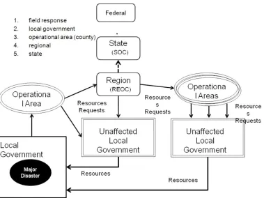
In case of an emergency, a variety of organizations have to respond to observed impacts and identified threats with resources that protect people, property, and the environment from loss. In order to coordinate the response, task resources and engage the right partners (e.g. military), critical information for decision support is required. The first response usually takes place at the local level. In case of a major disaster, observations are initially reported to the local operation center, which is equivalent to the county level. If it escalates, coordination with the regional information center is the next step. From there, other operational areas can be called in to provide mutual aid support. Depending on the disaster, coordination is further rolled up to the state/federal level.
Figure 3: Local to federal communication and support chains
organized way. The information itself is generated at all organizational levels using a variety of technologies as well as human observers. In case of an disaster, not only does geo-referenced (GIS) data need to be integrated, but lots of other types, such as tables, reports, images, field observations, diagrams, or checklists need to be served as well. Those types cannot be easily represented in traditional GIS.
The clearinghouse started in 1971 with five managing partners, the California Geological Survey, the US Geological Survey, California Office of Emergency Services, Earthquake Engineering Research Institute, California Safety Commission. In case of an emergency, the entire range of organizations makes use of the clearinghouse, including organizations dealing with utilities, emergency responders, researchers, etc.
7.2.2 Data & Services
Data provided by the USGS is key to several partner organizations of the California Clearinghouse. The data includes aerial photography, various remote sensing data, LIDAR, several national map products, sensor networks (e.g. provided by the
Department of Water Resources) or earthquake sensing devices, the Geospatial Multi-Agency Coordination platform (GeoMAC), National Hydrography Dataset (NHD), Fire and Hazard REST services from the Natural Hazard Support System (NHSS), Hazards Data Distribution System (HDDS) Explorer. The following figure represents the
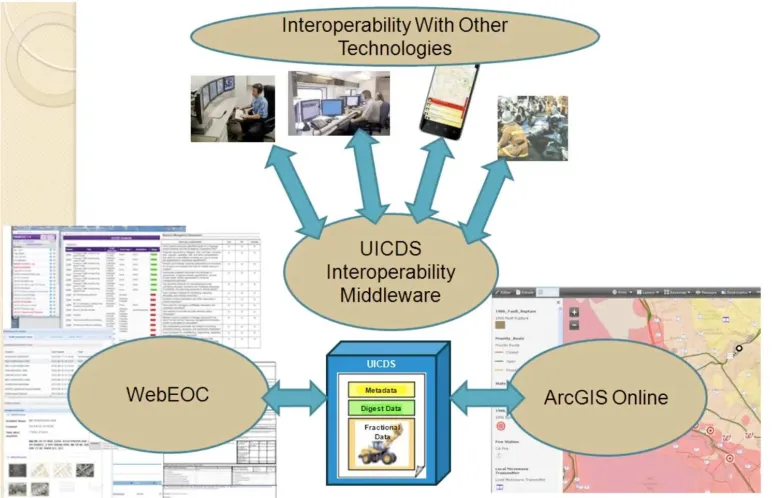
technology decisions taken by the California Governor's Office of Emergency Services.
CalEOS has adaptors to a number of technologies, e.g. WebEOS, ArcGIS online, Unified Incident Command and Decision Support (UICDS), and a number of other technologies used in the field or by other organizations. The UICDS middleware plays a central role for data communication. A key challenge in the past has been to communicate and to work collaboratively on geospatial information with other agencies and organizations in the geospatial world, given that there are roughly 150-200 different interfaces (geospatial and non-geospatial) that exit in common emergency management tools and related services. UICDS represents data in a number of standard formats that come from the geospatial community, the emergency management community, or the military. Formats include OGC formats such as KML, GML, and O&M; or NIEM (which uses GML for encoding location/geographic elements). Arriving data is converted into the best fitting standard for a particular use. This approach allows the use a single platform for
representing geospatial information: ArcGIS online. Putting all geospatial information on ArcGIS online has solved the problem of the high number of different interfaces and formats to a large extent, as long as the necessary software licenses can be afforded by all participating organizations.
The various text-based or report-based incident information systems used in the past have been superseded by a customized version of WebEOC, an incident management system developed by Intermedix Corp. Though WebEOC has a viewer component, it is not really a GIS tool. Therefore, geospatial information received from the various levels (local to regional to state and federal level) gets ported to ArcGIS online for efficient collaboration with external partners. This approach ensures that data is aggregated as necessary and consistently communicated across all organizations involved in the disaster management operation. Being synchronized at the state level, it is ensured that all organizations can view the same data, even though with their specific client applications that uses adapted representations.
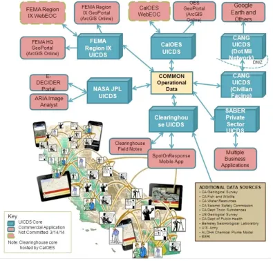
The key role of UICDS is further illustrated in the figure 5. This figure illustrates the coordination, communication and data orchestration, between a number of organizations in an earthquake event, where there is limited time for data discovery. Incoming data needs to be analyzed and combined with other existing data, new data is produced as a result, and new maps are dynamically created with multiple layers. All these data become part of the Common Operational Data (COD), which is exchanged between systems using various UICDS middleware implementations, operated by organizations on various administrative levels. Therefore, the efficient integration of any data set into the UICDS middleware layer is critical.
Figure 5: Technology relationships in case of disaster management operations
7.2.3 Recommendations
The following recommendations have been discussed and derived from the online meeting and use case analysis:
1. Embraced by DHS and DoD, the Unified Incident Command and Decision Support (UICDS) middleware is becoming more and more important in the domain of disaster management. Thus, by providing a direct connection into UICDS middleware from USGS services would overcome huge interoperability burdens. USGS data would become part of the Common Operational Data, i.e. data following a limited number of information models that are directly supported by UICDS. This process could be optimized by establishing a point of contact to coordinate between USGS, UICDS and OGC.
other types of OGC Web services (e.g. WMS, WFS, SOS and WCS) as well as, multiple formats.
3. All USGS services should be tested for full standard compliancy to the necessary detail.
7.3 Louisiana DOTD
The Louisiana Department of Transportation and Development serves the transportation and water resource needs of Louisiana residents, businesses and government partners. Here, we discuss experiences from the GIS & emergency operations before, during, and after the hurricanes of 2005.
7.3.1 Use Case
The use case addressed preparation, analysis, and clean-up operations in the context of hurricane Katrina in 2005. Almost a decade has passed since that event, and policies and procedures have changed, following the general path towards digitalization and rapid information exchange using mobile devices (smart phones, tablets, etc.) instead of printing and distributing paper maps. Nevertheless, the principle workflows in terms of data discovery, aggregation, analysis, and produced type and content of maps remain the same, independent of changing distribution mechanisms.
Figure 6: Aggregated data intended to be served as a service by DOTD
7.3.2 Data & Services
Louisiana DOTD uses specific services from USGS that are or are intended to be complemented with additional data sets, such as further hydrologic data, elevation data, weather and storm surge data, road and highway data, etc. The data services used so far include
WFS: geonames, WFS: govunits, WFS: structures, WFS: transportation,
SOS: Aggregate Water Use Data System (AWUDS), WFS: NHDPlus,
WCS: EDC Land Cover,
WCS: National Elevation Dataset,
WFS: Earth Resources Observation and Science (EROS) Center
Real time data is of major interest, as data is often used to identify specific areas or serves as a basis for management operations, e.g. the number and types of pumps to dry out a flooded area or current debris removal situation. In order to process data in DOTD’s GIS, data, in particular image data, needs to be transformed into vector data for further
processing. This processing is not necessarily done by DOTD, but by other organizations such as FEMA or DHS, that reissue processed image data as services.
Mobile devices become more and more important in daily operations, as they allow conveying real time information from the field to the command centers.
7.3.3 Recommendations
ArcGIS Online and other ESRI client products are widely used within DOTD. Therefore, it is recommended to ensure that those ESRI products are fully compliant with OGC enabled Web services interfaces. This allows ArcGIS Online as well as other ESRI products to access USGS Web services as clients; and allows other clients to access the data when running in server mode. Only the full support of the various OGC enabled interfaces both in client and server mode offers maximum interoperability and user experience.
7.4 US Fish and Wildlife Service
7.4.1 Use Case
In this use case, we analyze the work performed by the US Fish and Wildlife Service (USFWS), ecological services division, in the context of projects related to endangered species and 404 permits, which pertain to discharge of dredged and fill material into US waterways.
directly encompassing wetlands and wildlife resources, conducts site visits to assess biological functionality and habitat quality, coordinates with local, state, and federal agencies, and comments to the Army Corps of Engineers”
(http://www.fws.gov/charleston/404Permits.html).
The in-house part of those activities includes intensive GIS-based analysis of species, habitants, and environments. To perform this job, USFWS has various data layers available with regards to species locations and habitats at a very fine scale. Those data layers are complemented by data coming from USGS and other sources. Using QGIS and ArcGIS clients, USFWS analyzes a variety of data sets by loading it into the client application and by applying typical GIS operations on the various overlaid data sets. Therefore, data in vector formats or well-described raster data is preferred over pure imagery data.
Regarding external data, USFWS prefers having direct access to well-maintained data offered at Web services interfaces rather than keeping local copies of full data sets that do not get maintained. In terms of imagery, accessing external services rather than
maintaining local repositories frees up lots of memory space in addition. These Web services shall implement OGC standards, as those services can easily be integrated into the client applications and do not require substantial re-configuration if changes to the services are applied. In the past, several vendor-specific services became unavailable after the service software was modified. Caching of Web service data is an option, but not necessary as long as service availability and accessibility is ensured.
To exchange views on different data sets, USFWS makes us of Arc mxd-files to share layer configurations and data representations with biologists and other organizations. This approach works very well if the partnering organization uses QGIS, as appropriate plugins exist to handle mxd files. The ESRI software ArcGIS allows exchanging view configurations WMS set ups, but WFS is not supported out of the box. ArcGIS requires the interoperability extension to be installed. This ESRI issue hinders the integration of WFS services.
7.4.2 Data & Services
In terms of external data sources, USFWS cooperates with other organizations, such as the state. The state operates NC One Map, “a public service providing comprehensive discovery and access to North Carolina's geospatial data resources. NC OneMap, the State's Clearinghouse for geospatial information, relies on data sharing and partnerships.” (http://nconemap.com) The platform features spatial exploration and supports searching for specific service types among other criteria. Other external data sets used include:
USGS Hydro Points (from Geonames) are very useful to identify locations referred to using historical names. This is particularly relevant in the context of permits issued at times when other names had been in place.
USGS Transportation gives useful information about transportation elements, but does not always provides data at the required fine scale.
USGS Administrative layer is confusing, as there is little information available on what can be done with the service
USGS 24k Index5: The USGS 24k Topo Map Boundaries layer is a very
useful data set, as an up to date version of this layer is important. It happens often that quadrangle references or references to a section on a quad-sheet are given in submissions for a specific activity.
USGS Topographic Base Maps are useful, but there where mixed experiences regarding the accessibility of those data. Sometimes no data was available at all. It seemed to be a bandwidth issue that could not further be localized. It might be an internal problem to USFWS. In any case, the topographic base map layers are important information, in particular when combined with Open Street Maps data.
2012 National Agriculture Imagery Program (NAIP)6 data is used often in
conjunction with state-owned ortho-imagery, available at 6inch resolution, flown in winter 2011 and served at a WMS interface. As the NAIP data is from summer 2012, both data sets combined allow understanding changes in seasons.
EPA/USGS National Hydrography Dataset plus (NHDplus)7catchments are
an important layer, but even though the connection to the WMS was success,
5 “This layer presents the geographic extent of USGS 1:24,000 topographic maps (7.5- by 7.5-minute quadrangles) for
the conterminous U.S. forty-eight states and District of Columbia. It provides quadrangle name, identification number, publication data, and map coverage by state for each quadrangle. This large-scale index grid is appropriate for display at more detailed scales.” (http://www.arcgis.com/home/item.html?id=4bf2616d2f054fbe92eadcdc9582a765)
6 “The National Agriculture Imagery Program (NAIP) collects leaf-on (as opposed to the more common leaf-off) aerial
imagery at 1 or 2 meter resolution for the United States. This imagery is used for estimating crop plantings and yields. 2012 - statewide, 1 meter resolution, 4-band (true color and color-infrared) GeoTIFF tiles”
(http://www.lib.ncsu.edu/gis/naip.html)
7 NHDPlus is a geo-spatial, hydrologic framework dataset envisioned by the US Environmental Protection Agency.
no data is available for North Carolina. In those situations, it is difficult to understand if no data means that there is indeed no data available, or if the service is malfunctioning. Catchment areas are an important data set that would ideally be served at a WFS interface.
Various USGS WCS services caused various error messages, e.g. EDC Landcover.
In principle, USFWS is interested in having as many base data layers as possible that are relevant to a biologist as OGC compliant Web services, ideally WFS.
7.4.3 Recommendations
USFWS makes use of a number of USGS data services. As those services become more and more important to them, requirements for availability and reliability are high. In addition, USFWS uses several client applications, in particular QGIS and ArcGIS. It would be important to test USGS services with different versions of those clients and provide this information online. Consumers could use it to optimize their systems and make better use of the services offered.
The existing services are already of big value to USFWS. In addition to what is available, USFWS would like to get access to water gage information at a WFS interface. The USGS water resources division already makes data available as WaterML as a proprietary Web service. It would be great to have a WFS serving synoptic sampling data, including attributes for time of record, discharge, any chemical constituents analyzed, and the sampling location. If those services do exist, they are difficult to discover.
It would be helpful for users to have some sort of service availability overview informing about availability of services, as some client tools do not show any error message if no data is served. This behavior gives inconsistent experiences to users, as it is not clear if the service cannot provide any data for a particular query, or is not behaving properly. This is an issue that should be addressed by client developers as well.
USGS should consider starting a mailing list where people get notified about new services becoming available, as working routines often do not include discovery activities. For example, USFWS did not know about the availability of NHDplus catchment data served at a WFS interface. Clients use what they are used to and often only add new services if actively notified about them. Experiences in the past have even shown that catalog orchestration often does not really work. Once this issue is solved, tools could start polling for new services at a single, top-level endpoint, in contrast to many concurrent systems. As an example, USFWS currently uses ServCat8,
8 The Natural Resource Program Center (NRPC) is collaborating with the National Park Service’s (NPS) Inventory and
ScienceBase9, and NC One Map, i.e. three different systems with different interfaces and
APIs. Accessing all three of them through data.gov would simplify the process, but requires careful testing of service orchestration aspects.
7.5 Troup County, GA
7.5.1 Use Case
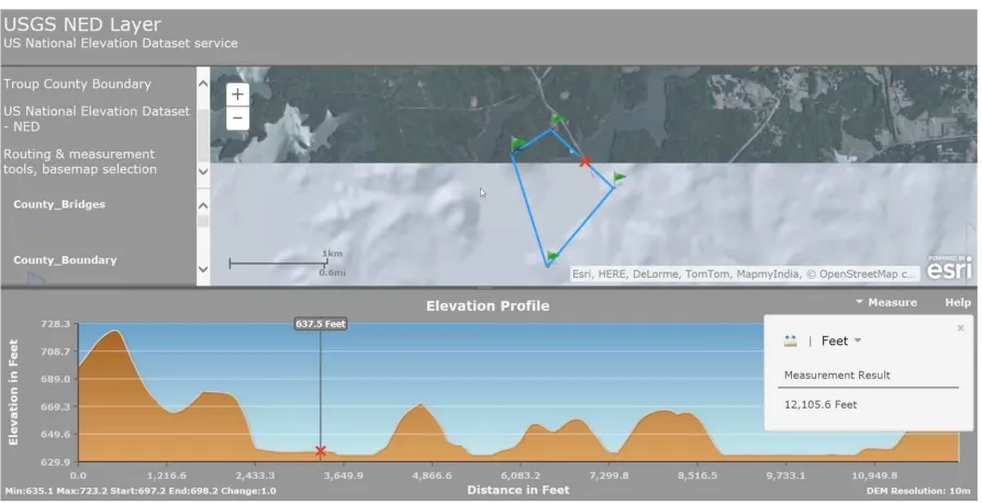
The goal is to make as many data layers available to county officials as required. Due to the lack of licenses for commercial products, county officials cannot easily access the various data layers, in particular as they are not familiar with open source or free software client applications. Therefore, the goal is to develop web based front ends to various data sets. The figure below demonstrates this approach using the USGS national elevation dataset. The client displays map data from various sources and allows drawing multi-lines on that map. The elevation data is displayed within a separate window
Figure 7: Troup County client to visualize elevation data using USGS NED
The front end is currently still under development. The goal is to make it available on mobile platforms and to allow capturing new data directly on the mobile device. Other examples include an bridge one-stop shop, where all information about bridges including elevation data is made available, or various overlays of KML files with current
9 Science Base is a collaborative scientific data and information management platform used directly by science teams.
imagery and topography data layers. The front ends are usually generated using ArcGIS Explorer.
7.5.2 Data & Services
Troup County tested different several services and experienced some problems connecting to it. The most important one is a reliable elevation data, served at a WCS interface.
7.5.3 Recommendations
Improve communications regarding planned software updates, to allow connecting/adapting to the new services once they become available.
7.6 Oregon Coastal Management Program
7.6.1 Use Case
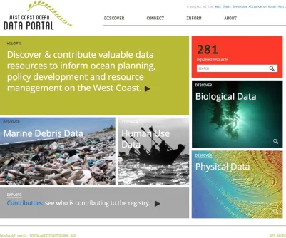
Figure 8: West Coast Ocean Data Portal (http://portal.westcoastoceans.org)
The portal mostly contains ocean-related data, but can allow access to other services as well, e.g. those provided by USGS. The goal is to provide simple access to those services, serve as a one-stop shop, and advertise data and services to groups not familiar with specific data sets.
The portal is built on an ESRI Geoportal in the background, but with an entirely
customized user interface. Each service or data set is registered at a CSW (OGC Catalog Service), using ISO 19115 metadata records. The catalog then allows access to the data, often through multiple formats and protocols, such as WMS, KML, JSON, zipped shape files etc.
The customers of the portal use a variety of tools to interact with the data. The state agencies of Oregon have a license agreement with ESRI and can use ESRI GIS products (ArcMap with many plugins) to work with data and services. In contrast, local
software tools, with QGIS being the main tool of choice. University partners bring in additional tools, as many of them do not come from the ESRI/GIS environment.
There is an application under development called the MarinePlanner. This application is based on OpenLayers, which allows simple integration of many OGC service interfaces. The goal of this application is to make many services available at a single point of entry, allowing overlay of many services and data types. The planner allows a user to bookmark a number of search results from the portal, which are then automatically imported and visualized. In this regard, the planner works as an interactive mapping environment. The plan is to support all standard OGC service types, such as WMS, WFS, and WCS.
7.6.2 Data & Services
The platform features several viewers that mostly work with WMS instances, operated and maintained by a variety of partners. Currently, the portal does not use any of the USGS services listed on the provided overview, it would be very interesting to add WFS Geonames, NHDplus and elevation data (NED) services. In this regard, it has to be noted that WCS services can be used directly from within ArcMap, whereas WFS services require the installation of the ArcGIS Data Interoperability extension. Even though there is a version of the plugin that is offered free of charge, it is a barrier that it does not come with any of the low-level ArcMap installation packages.
7.6.3 Recommendations
In some cases, GeoJSON would be preferred as a WFS response format. This would allow using powerful tools and libraries, such as D310, to analyze and process the data
without requiring fundamental GIS knowledge on the client side.
As a general comment, some services use numerical systems to name feature types or offered layers or coverages. This might be the default offered by the service
implementation, but is not very useful for clients to work with. In this situation, clients are required to issue further requests, as there is little information that can be retrieved from sequential numbers rather than meaningful names.
7.7 NGA use of USGS Services
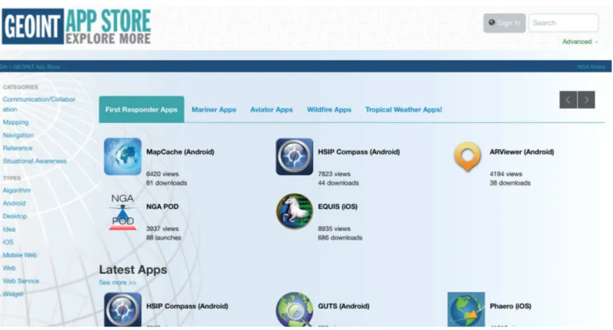
7.7.1 Use Case
The NGA GeoInt App Store (https://apps.nga.mil) serves as an aggregation portal for geospatial intelligence data and services. In this, the NGA App Store is not literally an application store, but serves as an access point to all sorts of information, such as data served at Web service interfaces operated and maintained mainly by various government
10 D3.js is a JavaScript library for manipulating documents based on data. D3 helps you bring data to life using HTML,
organizations, ArcGIS scripts, Websites, iOS or Android applications, or any other geospatial intelligence related resources that is of value to the user community.
Figure 9: NGA GEOINT App Store (http://apps.nga.mil)
The app store has entries for various USGS products, such as the national map products or the USGS Natural Hazard Support System (NHSS).
In addition to exposing USGS products in the app store, various groups within NGA make direct use of USGS services. Those groups include the Integrated Working Group – Readiness, Response and Recovery (IWG-R3), basically NGA’s disaster response group; DHS support teams within NGA; or FEMA liaison teams, e.g. with FEMA National Response Coordination Center (NRCC11).
7.7.2 Data & Services
Several groups within NGA make use of USGS products. Of particular interest are the river gauge data, GeoMAC12 data, and data services usually consumed by first
11 The FEMA NRCC is a multiagency entity operating from FEMA headquarters that functions as the operational
component of the DHS NOC. The NRCC coordinates personnel and resource deployments to support disaster
operations and prioritizes interagency allocation of resources. It maintains situational awareness linkages with regional, state, and local partners and 24 x 7 watch team. The NRCC is staffed to support daily monitoring activities with the ability to surge in support of catastrophic events.
12 The Geospatial Multi-Agency Coordination or GeoMAC, is an internet-based mapping application originally
responders. Some issues have been experienced in the past with non-matching geodetic reference systems, such as WGS84 used by USGS vs. NAD83 used by NGA.
7.7.3 Recommendations
The apps in the NGA app store are currently maintained by NGA. It would be highly beneficial if those apps could be maintained by USGS directly. An issue is automating the process of registering apps. Currently, NGA is not notified if new services come online or if existing ones get modified. One possible solution would be to modify the app store approach in a way that it harvests metadata about USGS services directly from a USGS catalog service.
8 General Recommendations
In summary, the following recommendations can be made to improve the user experience with USGS Web services:
The service compliance tests have shown that many services are not fully
compliant with the OGC standard being tested, with varying relevance for service usability. Testing compliance for older service specifications, e.g. WFS 1.1, is often limited due to missing conformance classes in the standard and/or limited matching between the standard, abstract test suite, and compliance tests
implementation. Given the high number of existing implementations for those services (e.g. 239 WFS 1.1 implementations compared to 39 WFS 2.0
implementations), it is recommended to rework the old standards and abstract test suites and improve the service compliance test implementations. Switching to WFS 2.0 is an option, but often not necessary and causes other issues that commonly accompany new software releases, in particular in distributed environments where clients have been fine-tuned to optimize interaction with service instances.
The compliance test suite for WFS 1.1 should be reworked to improve service-testing experiences for service providers, possibly developing a new conformance class. For example, Basic WFS 1.1.0.
Many service instances are not fully compliant with the service specification, but still usable in practice. Therefore a categorization of test results should be
considered, e.g. “blocker, critical, minor”.
The naming of feature types or coverages often follows an opaque naming
convention. The same incomprehensible name is often used in the “Title” element and no further description is provided. Thus, it is very difficult for the user to understand what a particular data set can be used for. This is particularly true for generic client applications, such as QGIS or ArcGIS, where feature collections from WFS are loaded and quickly explored by reading the feature type names and titles or descriptions. Informative names such as “BirdHabitat” makes more sense than “cg34” and would save the user some time from running additional
DescribeFeatureType requests (which have been not much more informative in some cases).
As more and more services are used in complex situations, it is important to use proper namespace identifiers. Often, those identifiers change between response types. The namespace used in a GetCapabilities response should be identical with the one used in a GetFeature response.
experiences, it makes sense to run those tests before publishing a service. The CITE website can be found at http://cite.opengeospatial.org.
Many users discover a service through the word of mouth rather than catalogs that are consulted regularly. Therefore, it would make sense to accompany a service with some sort of message board that informs users of planned modifications to existing services are updated service offerings. Otherwise, many users give up using a particular service due to changed configurations or undocumented down times.
Annex A
Call for Participation
The call for participation is available online at Weblink13.
13
Annex B
Service Tests
The detailed reports on service tests are available online at Report 114, Report 215. It has
to be emphasized that the tests have been performed with limited resources. The goal was to help service operators to improve their services.
Bibliography
All references have been given inline
Revision history
Date Release Editor Primary clauses modified
Description
11/07/2014 0.1 Ingo Simonis All Initial version, covers first two webinars
28/07/2014 0.2 Ingo Simonis All Covers all webinars and service tests. 31/07/2014 0.3 Luis Bermudez 1, 4, 6, 7 Organized 1.1 so it clearly shows the
three main activities of the project. Added the section about CAT test 11/08/2014 0.4 Ingo Simonis 1, 2, 4, 5 Indices updated, minor corrections,
headings modified, references updated
13/08/2014 0.5 Ingo Simonis 8 Added
17/08/2014 0.7 Luis Bermudez 7.2.3 Cleaned bullet 3 25/08/2014 1.0 Ingo Simonis 8 Complemented
28/08/2014 1.1 Ingo Simonis All Edits received from David Danko included, recommendations and annexes updated
02/10/2014 1.2 Ingo Simonis All Comments from Calgary TC considered
15/10/2014 1.3 Luis Bermudez All Overall revision 16/10/2014 1.4 Ingo Simonis All Final edits