Publication Date: 2016-01-18
Approval Date:2015-09-17
Posted Date: 2015-08-21
Reference number of this document: OGC 15-052r1
Reference URL for this document:http://www.opengis.net/doc/PER/tb11_rest_er
Category: Public Engineering Report
Editor:Frédéric Houbie
OGC
®Testbed 11 REST Interface Engineering Report
Copyright © 2016 Open Geospatial Consortium.
To obtain additional rights of use, visit http://www.opengeospatial.org/legal/.
Warning
This document is not an OGC Standard. This document presents a discussion of technology issues considered in an initiative of the OGC Interoperability Program. This document does not represent an official position of the OGC. It is subject to change without notice and may not be referred to as an OGC Standard. However, the discussions in this document could very well lead to the definition of an OGC Standard. Recipients of this document are invited to submit, with their comments, notification of any relevant patent rights of which they are aware and to provide supporting documentation.
Document type: PublicEngineering Report Document subtype: NA
ii Copyright © 2016 Open Geospatial Consortium. License Agreement
Permission is hereby granted by the Open Geospatial Consortium, ("Licensor"), free of charge and subject to the terms set forth below, to any person obtaining a copy of this Intellectual Property and any associated documentation, to deal in the Intellectual Property without restriction (except as set forth below), including without limitation the rights to implement, use, copy, modify, merge, publish, distribute, and/or sublicense copies of the Intellectual Property, and to permit persons to whom the Intellectual Property is furnished to do so, provided that all copyright notices on the intellectual property are retained intact and that each person to whom the Intellectual Property is furnished agrees to the terms of this Agreement.
If you modify the Intellectual Property, all copies of the modified Intellectual Property must include, in addition to the above copyright notice, a notice that the Intellectual Property includes modifications that have not been approved or adopted by LICENSOR. THIS LICENSE IS A COPYRIGHT LICENSE ONLY, AND DOES NOT CONVEY ANY RIGHTS UNDER ANY PATENTS THAT MAY BE IN FORCE ANYWHERE IN THE WORLD.
THE INTELLECTUAL PROPERTY IS PROVIDED "AS IS", WITHOUT WARRANTY OF ANY KIND, EXPRESS OR IMPLIED, INCLUDING BUT NOT LIMITED TO THE WARRANTIES OF MERCHANTABILITY, FITNESS FOR A PARTICULAR PURPOSE, AND NONINFRINGEMENT OF THIRD PARTY RIGHTS. THE COPYRIGHT HOLDER OR HOLDERS INCLUDED IN THIS NOTICE DO NOT WARRANT THAT THE FUNCTIONS CONTAINED IN THE INTELLECTUAL PROPERTY WILL MEET YOUR REQUIREMENTS OR THAT THE OPERATION OF THE INTELLECTUAL PROPERTY WILL BE
UNINTERRUPTED OR ERROR FREE. ANY USE OF THE INTELLECTUAL PROPERTY SHALL BE MADE ENTIRELY AT THE USER’S OWN RISK. IN NO EVENT SHALL THE COPYRIGHT HOLDER OR ANY CONTRIBUTOR OF
INTELLECTUAL PROPERTY RIGHTS TO THE INTELLECTUAL PROPERTY BE LIABLE FOR ANY CLAIM, OR ANY DIRECT, SPECIAL, INDIRECT OR CONSEQUENTIAL DAMAGES, OR ANY DAMAGES WHATSOEVER RESULTING FROM ANY ALLEGED INFRINGEMENT OR ANY LOSS OF USE, DATA OR PROFITS, WHETHER IN AN ACTION OF CONTRACT, NEGLIGENCE OR UNDER ANY OTHER LEGAL THEORY, ARISING OUT OF OR IN CONNECTION WITH THE IMPLEMENTATION, USE, COMMERCIALIZATION OR PERFORMANCE OF THIS INTELLECTUAL PROPERTY. This license is effective until terminated. You may terminate it at any time by destroying the Intellectual Property together with all copies in any form. The license will also terminate if you fail to comply with any term or condition of this Agreement. Except as provided in the following sentence, no such termination of this license shall require the termination of any third party end-user sublicense to the Intellectual Property which is in force as of the date of notice of such termination. In addition, should the Intellectual Property, or the operation of the Intellectual Property, infringe, or in LICENSOR’s sole opinion be likely to infringe, any patent, copyright, trademark or other right of a third party, you agree that LICENSOR, in its sole discretion, may terminate this license without any compensation or liability to you, your licensees or any other party. You agree upon termination of any kind to destroy or cause to be destroyed the Intellectual Property together with all copies in any form, whether held by you or by any third party. Except as contained in this notice, the name of LICENSOR or of any other holder of a copyright in all or part of the Intellectual Property shall not be used in advertising or otherwise to promote the sale, use or other dealings in this Intellectual Property without prior written authorization of LICENSOR or such copyright holder. LICENSOR is and shall at all times be the sole entity that may authorize you or any third party to use certification marks, trademarks or other special designations to indicate compliance with any LICENSOR standards or specifications.
This Agreement is governed by the laws of the Commonwealth of Massachusetts. The application to this Agreement of the United Nations Convention on Contracts for the International Sale of Goods is hereby expressly excluded. In the event any provision of this Agreement shall be deemed unenforceable, void or invalid, such provision shall be modified so as to make it valid and enforceable, and as so modified the entire Agreement shall remain in full force and effect. No decision, action or inaction by LICENSOR shall be construed to be a waiver of any rights or remedies available to it.
Copyright © 2016 Open Geospatial Consortium. iii
Contents
Page1 Introduction ... 2
1.1 Scope ... 2
1.2 Document contributor contact points ... 2
1.3 Future work ... 2
1.4 Foreword ... 2
2 Terms and definitions ... 3
3 Abbreviated terms ... 3
4 OGC Testbed 11 REST ER – Overview ... 3
5 REST ... 4
5.1 What is REST ? ... 4
5.1.1 Client-Server ... 4
5.1.2 Stateless ... 4
5.1.3 Cacheable ... 5
5.1.4 Uniform Interface ... 5
5.1.5 Resource-Based ... 5
5.1.6 Manipulation of Resources through Representations ... 6
5.1.7 Self-descriptive Messages ... 6
5.1.8 Hypermedia as the Engine of Application State (HATEOAS) ... 6
5.1.9 Layered System ... 7
5.1.10 Code-on-demand ... 7
5.2 Contrasting REST with OGC Web Services ... 7
5.3 Common REST API Practices to Consider ... 8
iv Copyright © 2016 Open Geospatial Consortium.
5.3.2 Provide Sensible Resource Names ... 10
5.3.3 Use HTTP Response Codes to Indicate Status ... 11
5.3.4 Create Fine-Grained Resources ... 13
5.3.5 Consider Connectedness ... 13
5.4 ROA vs SOA ... 14
5.4.1 Service Oriented Architecture (SOA) ... 14
5.4.2 Resource Oriented Architecture (ROA) ... 15
6 The History of OGC and REST ... 16
6.1 Analysis of REST Initiatives within OGC ... 16
6.1.1 Geoservices REST – Overview ... 16
6.1.2 Why implement the GeoServices REST specification? ... 17
6.1.3 How to implement the GeoServices REST specification. ... 18
6.1.4 Resources and Operations ... 18
6.1.5 Response Formats ... 18
6.1.6 REST and Pragmatic Considerations ... 19
6.1.7 Summary ... 20
6.1.8 Further References ... 20
6.2 WaterML 2.0 API ... 21
6.3 Web Map Tile Service (WMTS) RESTful binding ... 22
6.3.1 Criticism of the URL template approach. ... 23
6.3.2 Caching and considerations for future parameter extensions. ... 23
6.3.3 WMTS Simple ... 24
6.4 REST binding for WFS 2.5 ... 25
6.4.1 Introduction ... 25
Copyright © 2016 Open Geospatial Consortium. v
6.4.2.1 Service root ... 25
6.4.2.2 Representation of features ... 26
6.4.2.3 Content negotiation ... 26
6.4.2.4 Hypermedia controls ... 26
6.4.2.5 URI Templates ... 30
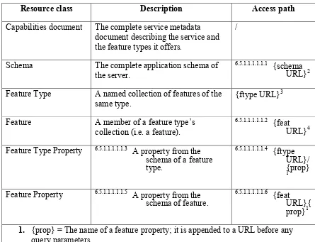
6.5 Summary of resources ... 31
6.6 Feature access ... 32
6.6.1 Introduction ... 32
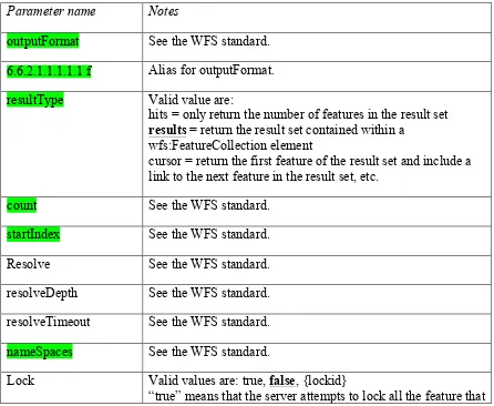
6.6.2 Query parameters ... 33
6.6.3 Examples ... 34
6.6.3.1 Introduction ... 34
6.6.3.2 Accessing a services capabilities document ... 35
6.6.3.3 Accessing the application schema of the service ... 35
6.6.3.4 Accessing the feature collection ... 35
6.6.3.5 Accessing a specific feature in GML ... 37
6.6.3.6 Accessing a subset of features ... 37
6.7 Transactions ... 39
7 Accomplishments ... 39
vi Copyright © 2016 Open Geospatial Consortium.
Figures
PageFigure 1 – WaterML2.0 part 2 API docs ... 21
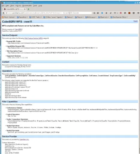
Figure 2 – REST WFS Capabilities document in HTML ... 36
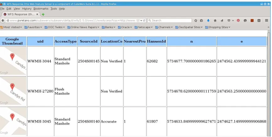
Figure 3 – REST WFS query response in HTML ... 38
Tables
Page Table 2 – Cross-reference of OGC standards to REST practices ... 16Table 3 – OGC Testbed 11 WFS 2.5 Implementations ... 25
Table 4 – Mapping Open Search Url attributes to ATOM link attributes ... 30
Table 5 – Summary of WFS 2.5 REST resources used in OGC Testbed 11 ... 32
Copyright © 2016 Open Geospatial Consortium. 1
Abstract
REST architectural principles are associated with optimal functioning of the Web but their manifestation in geospatial Web services standards is not straightforward. This OGC Engineering Report (ER) examines their use both in existing OGC Services standards and in new or revised service standard proposals, some of which were implemented during OGC Testbed 11. The ER then defines possible uniform practices for developing bindings or interaction styles for OGC Web services that appropriately leverage REST principles.
Business Value
Web service standards that are easier to implement and more compatible with Web technologies will have a higher rate of implementation and a greater value for vendors, customers, and the OGC. The REST architectural style has the potential for simplicity, scalability, and resilience if it can be adapted to the effective exchange of geospatial information across the Web.
Keywords
2 Copyright © 2016 Open Geospatial Consortium.
OGC
®Testbed 11 REST Interface Engineering Report
1 Introduction
1.1 Scope
This OGC Engineering Report (ER) is a deliverable of the OGC Testbed 11 activity. The ER describes the results of study of REST work at OGC. The ER also describes some guidelines for future definition of REST API within OGC process.
1.2 Document contributor contact points
All questions regarding this document should be directed to the editor or the contributors:
Name Organization
Frédéric Houbie (editor) Luciad
Satish Sankaran Esri
Joshua Lieberman Tumbling Walls
Peter Vretanos CubeWerx
Joan Masó UAB-CREAF
1.3 Future work
The following items were identified for consideration in future initiatives: Uniform REST binding(s) for OGC services
REST API to support linked geospatial data 1.4 Foreword
Attention is drawn to the possibility that some of the elements of this document may be the subject of patent rights. The Open Geospatial Consortium shall not be held
responsible for identifying any or all such patent rights.
Copyright © 2016 Open Geospatial Consortium. 3 2 Terms and definitions
For the purposes of this report, the following terms and definitions apply.
2.1
Application Programming Interface (API)
An interface definition that permits invoking services from application programs without knowing details of their internal implementation.
3 Abbreviated terms
EPSG European Petroleum Survey Group GIS Geographic Information System GML Geography Markup Language
ISO International Organization for Standardization OGC Open Geospatial Consortium
SQL Structured Query Language SRS Spatial Reference System UML Unified Modeling Language URI Uniform Resource Identifier XML Extensible Markup Language
XSLT Extensible Stylesheet Language Transformations
4 OGC Testbed 11 REST ER – Overview
4 Copyright © 2016 Open Geospatial Consortium. architectural style while retaining the service functionality on which client applications depend.
The following chapters document the results of the work conducted in OGC Testbed 11 for these tasks.
5 REST
5.1 What is REST ? 1
REST (Representational State Transfer) is a term coined by Roy Fielding2 in his doctoral
dissertation to describe an architectural style for “distributed hypermedia systems” such as the Worldwide Web that are to have desirable characteristics including separation of concerns, scalability, resiliency, visibility, and reliability. This style rests on five constraints on how computing systems are configured and component interactions are carried out:
5.1.1 Client-Server
The uniform interface separates clients from servers. This separation of concerns means that, for example, clients are not concerned with data storage, which remains internal to each server, so that the portability of client code is improved. Servers are not concerned with the user interface or user state, so that servers can be simpler and more scalable. Servers and clients may also be replaced and developed independently, as long as the interface is not altered.
5.1.2 Stateless
REST is an acronym for Representational State Transfer, so why statelessness? Although both clients and servers necessarily save their own persistent state information, the interactions that cause each to change state are themselves stateless. No interaction depends for its success on the content of other interactions. The necessary information to process a request, for example, is contained within the request itself, whether as part of the URI, query-string parameters, body, or headers.
Most of us who have been in the industry for a while are accustomed to programming within a container that provides “session state” across multiple HTTP requests. In REST, the client must include all information for the server to fulfil the request, resending state information or references as necessary if it applies to multiple requests. Statelessness enables greater scalability since the server does not have to maintain, update or
1 Mainly extracted from http://www.restapitutorial.com/, one of the most concise and understandable REST
explanations found during the analysis
Copyright © 2016 Open Geospatial Consortium. 5 communicate that session state. Additionally, load balancers don’t have to worry about session affinity for stateless systems.
So what’s the difference between state and resource? Resource state is the information or capability a server uses to create resource representations – the data stored in the
database, for instance. Application or client state is the information that affects
application flow or user interactions in a client and is built up from (among other sources) resource representations exchanged with servers in stateless interactions.
5.1.3 Cacheable
As on the World Wide Web, clients can cache responses. Server responses implicitly or explicitly define themselves as cacheable, or not, to prevent clients reusing old or inappropriate data in response to further requests. Well-managed caching partially or completely eliminates some client–server interactions, improving scalability and
performance, as long as the requests, e.g. URL’s are defined in such a way as to support as much reuse as possible. For example, if a client is able to construct many different requests for the same response, this prevents optimal caching performance.
5.1.4 Uniform Interface
The uniform interface constraint applies to interactions between client and server components, minimizing the special knowledge that each must have of the other and allowing maximum variety in the components that are able to interact with one another. It simplifies and decouples the architecture, which enables each part to evolve
independently. As applied to the Worldwide Web, this uniform interface is generally taken to be based on proper and consistent use of HTTP, although other uniform
interfaces are certainly possible, particularly for interaction styles not well supported by HTTP.
REST principles expand on the notion of a uniform protocol such as HTTP and describe several practices that increase the uniformity of the entire client-server interaction:
5.1.5 Resource-Based
In what is termed “resource oriented architecture (ROA), a server’s capabilities are defined in terms of conceptual resources that are identified by URI’s and addressable only by a uniform set of operators such as the HTTP verbs. By contrast, a Service
Oriented Architecture (SOA) approach defines server capability in terms of specific, even idiosyncratic operations. It is generally true that a client application needs to be coded specifically for each specific server operation it invokes. Therefore, a small and uniform number of operators should make client development easier and increase the range of servers that a client can interact with. This presumes, of course, that how a client
6 Copyright © 2016 Open Geospatial Consortium.
5.1.6 Manipulation of Resources through Representations
The resources themselves are conceptual (as far as the client is concerned) and any of a number of representations are what is actually exchanged with clients. For example, a server does not send its database, but rather, a HTML, XML or JSON document that encodes requested database records. Such documents may be expressed, for instance, in French and encoded in UTF-8, depending what the client requests and the server can provide. When a client holds a representation of a resource, including any metadata attached, it has enough information to modify or delete the resource on the server, provided it has permission to do so.
5.1.7 Self-descriptive Messages
Each representation message returned by a server is supposed to include enough
information that a client is able to determine how to process the message without out-of-band code or information that is specific to that representation. An existing parser may be invoked, for example, by an Internet media type (previously known as a MIME type). While this is a valuable constraint for a resilient Web, the general effectiveness of media types in providing guidance for client processing has been somewhat overwhelmed by the variety of message types that have developed. Typically, a client application requires specialized code to deal with specialized media types or the ways in which specific representations may differ from general media types. This code is either built in based on out-of-band knowledge or it comes along with the response. Even HTML as a general media type is frequently supplemented by javascript code for specific application processing.
A notable form of self-descriptive message is, of course, hypermedia, in which various information media (text, pictures, videos, …maps) support application navigation by way of links. Where the processor of the document is a human (or the document is highly structured) and application flow consists of choosing the link to follow next, this type of self-descriptive message can be very effective.
Self-description also applies to responses explicitly indicating their cache-ability.
5.1.8 Hypermedia as the Engine of Application State (HATEOAS)
Copyright © 2016 Open Geospatial Consortium. 7
5.1.9 Layered System
Layers provide information hiding by presenting each server as simple component whether or not there is physically a population of components doing the actual
processing. A client cannot ordinarily tell whether it is connected directly to the initiating server of a work pipeline or hierarchy or intermediary along the way. This increases separation of concerns and therefore resiliency in case opaque server workflow needs to change. Intermediary servers may also improve system scalability by enabling load-balancing and by providing shared caches. Layers may also enforce security policies. 5.1.10 Code-on-demand
Fielding’s thesis actually includes a sixth architectural constraint that is considered optional, but carries to a logical conclusion that the less clients need to be equipped themselves for a specific application, the more loosely coupled a client server system can be. Clients in systems constrained this way are responsible for little more than executing code on documents that are both provided by the servers they interact with. Web
browsers executing downloaded javascript functions may be considered an example of this constraint.
5.2 Contrasting REST with OGC Web Services
Careful consideration of published REST principles, constraints, and practices show how they can lead to a Web-like distributed computing system with admirable qualities of scalability and loose coupling. Two of goals identified with these qualities, however, are at some odds with both the concept of Web services and existing OGC services
ecosystem. One goal is to abstract the model of server capabilities that a client needs to interact with, by means of a resource-representation approach and uniform interface. This leads to a common view that a uniform interface service standard such as HTTP is all that is required in the way of standards to promote interoperability between clients and
servers. This has led directly to a proliferation of REST API specifications that are customized as to both server resources and client applications, with a corresponding drop in reusability as developers concentrate on the interactions needed for each project. It is generally thought that RESTful API’s are easier to develop clients for. However, this is “ease” being offset by the need to continually re-develop on the client side as new improved API’s are devised. This contrasts with the OGC approach of standardizing reusable service interfaces that can be utilized to access many different resources of specific types for the benefit of a range of applications.
There is a second REST goal of minimizing specific client knowledge of server capability, resource type, or representation format. Again, there is a range of
8 Copyright © 2016 Open Geospatial Consortium. on the server and not on the client. This is again a contrast with the distributed
architectures for geospatial information processing targeted by OGC Web services. The role of these services has been to provide distinct, reusable portions of backend
computing capability such as data access or transformation that are then assembled by clients into complete applications (whether or not they are directly human-facing). When those client applications are browser-based, though, they are often (although not always) supported by an additional service tier of Web-based API’s that implement portions of processing logic specific to the particular application. This tier sometimes even comprises the actual client that interacts with OGC services such as Web Feature Service instances and then passes the results on to the browser-based user interface. These application services are rarely standardized per se, although there are
communications and/or widget frameworks that provide considerable regularity to client development tasks and may yet be a standardization target. Creating such application services would be much more difficult, though, if the components for rendering a map or searching a feature collection or storing large-scale datasets had to be re-created for each application.
The conclusion drawn by most Testbed 11 participants appears to be that whatever name is used (RITHMIC – Resource Interaction Through HTTP Method Invocation – was proposed as a substitute), there is value specifically in the geospatial domain in attempting to strike a balance between the value of specific REST principles and practices, and the demonstrated value of standardized component Web services . 5.3 Common REST API Practices to Consider
Whether their use can be termed RESTful or not (according to the constraints mentioned previously), a few recommended REST-like suggestions have been collected here. These six relatively easy to implement software practices often result in better, more usable services.
5.3.1 Use HTTP Verbs as more than a transport protocol
API consumers are capable of sending GET, POST, PUT, and DELETE verbs, and these verbs greatly enhance the clarity of what a given request does. Also, GET requests must not change any underlying resource data. Measurements and tracking may still occur, which updates data, but not resource data identified by the URI.
Generally, the four primary HTTP verbs are used as follows.
GET: Read a specific resource (by an identifier) or a collection of resources.
Copyright © 2016 Open Geospatial Consortium. 9 According to the design of the HTTP specification, GET (along with HEAD) requests are used only to read data and not change it. Therefore, when used this way, they are
considered safe. That is, they can be called without risk of data modification or corruption—calling it once has the same effect as calling it 10 times, or none at all. Additionally, GET (and HEAD) should be idempotent, which means that making multiple identical requests ends up having the same result as a single request.
Do not expose unsafe operations via GET—it should never modify any resources on the server.
PUT: Update a specific resource (by an identifier) or a collection of resources. Can also be used to create a specific resource if the resource identifier is known before-hand.
PUT is most-often utilized for update capabilities, PUT-ing to a known resource URI with the request body containing the newly-updated representation of the original resource.
However, PUT can also be used to create a resource in the case where the resource ID is chosen by the client instead of by the server. In other words, if the PUT is to a URI that contains the value of a non-existent resource ID. Again, the request body contains a resource representation.
Alternatively, use POST to create new resources and provide the client-defined ID in the body representation—presumably to a URI that doesn’t include the ID of the resource (see POST below).
On successful update, return 200 (or 204 if not returning any content in the body) from a PUT. If using PUT for create, return HTTP status 201 on successful creation. A body in the response is optional—providing one consumes more bandwidth. It is not necessary to return a link via a Location header in the creation case since the client already set the resource ID.
PUT is not a safe operation, in that it modifies (or creates) state on the server, but it is idempotent. In other words, if you create or update a resource using PUT and then make that same call again, the resource is still there and still has the same state as it did with the first call.
If, for instance, calling PUT on a resource increments a counter within the resource, the call is no longer idempotent. Sometimes that happens and it may be enough to document that the call is not idempotent. However, it’s recommended to keep PUT requests
idempotent. It is strongly recommended to use POST for non-idempotent requests. DELETE: Remove/delete a specific resource by an identifier.
10 Copyright © 2016 Open Geospatial Consortium. On successful deletion, return HTTP status 200 (OK) along with a response body,
perhaps the representation of the deleted item (often demands too much bandwidth), or a wrapped response. Either that or return HTTP status 204 (NO CONTENT) with no response body.
HTTP-spec-wise, DELETE operations are idempotent. If you DELETE a resource, it’s removed. Repeatedly calling DELETE on that resource ends up the same: the resource is gone. If calling DELETE say, decrements a counter (within the resource), the DELETE call is no longer idempotent. As mentioned previously, usage statistics and measurements may be updated while still considering the service idempotent as long as no resource data is changed. Using POST for non-idempotent resource requests is recommended.
There is a caveat about DELETE idempotence, however. Calling DELETE on a resource a second time will often return a 404 (NOT FOUND) since it was already removed and therefore is no longer findable. This, by some opinions, makes DELETE operations no longer idempotent, however, the end-state of the resource is the same. Returning a 404 is acceptable and communicates accurately the status of the call.
POST: Create a new resource. Also a catch-all verb for operations that don’t fit into the other categories.
The POST verb is most-often utilized to **create** new resources. In particular, it’s used to create subordinate resources. That is, subordinate to some other (e.g. parent) resource. In other words, when creating a new resource, POST to the parent and the service takes care of associating the new resource with the parent, assigning an ID (new resource URI), etc.
On successful creation, return HTTP status 201, returning a Location header with a link to the newly-created resource with the 201 HTTP status.
POST is neither safe nor idempotent. It is therefore recommended for non-idempotent resource requests. Making two identical POST requests will most-likely result in two resources containing the same information.
5.3.2 Provide Sensible Resource Names
Producing a great API is 80% art and 20% science. Creating a URL hierarchy
representing sensible resources is the artistry. Sensible resource names (which are just URL paths, such as /customers/12345/orders) improve the clarity of what a given request does. Appropriate resource names provide context for a service request, increasing understandability of the API. Resources are viewed hierarchically via their URI names, offering consumers a friendly, easily-understood hierarchy of resources to leverage in their applications. The resource structure in itself itself makes each resource easier for a client to understand and interact with.
Copyright © 2016 Open Geospatial Consortium. 11 Use identifiers in your URLs instead of in the string. Using URL
query-string parameters is fantastic for filtering, but not for resource names. o Good: /users/12345
o Poor: /api?type=user&id=23
Leverage the hierarchical nature of the URL to imply structure. Design for your clients, not for your data.
Resource names should be nouns. Avoid verbs as resource names. It makes things more clear. Use the HTTP methods to specify the verb portion of the request. Use plurals in URL segments to keep your API URIs consistent across all HTTP
methods, using the collection metaphor.
o Recommended: /customers/33245/orders/8769/lineitems/1 o Not: /customer/33245/order/8769/lineitem/1
Avoid using collection verbiage in URLs. For example ‘customer_list’ as a resource. Use pluralization to indicate the collection metaphor (e.g. customers vs. customer_list).
Use lower-case in URL segments, separating words with underscores (‘_’) or hyphens (‘-‘). Some servers ignore case so it’s best to be clear.
Keep URLs as short as possible, with as few segments as makes sense.
Look at some widely used APIs to get the hang of this and leverage the intuition to refine API resource URIs. Some example APIs are:
Twitter: https://dev.twitter.com/rest/public
Facebook: https://developers.facebook.com/docs/graph-api/reference LinkedIn: https://developer.linkedin.com/docs/rest-api
More in the Geo domain, Google APIs has some good hints for integration of spatial/temporal characteristics in the URLs :
https://developers.google.com/maps/documentation/webservices/
These examples emphasize identifying each granular resource in the URL path, even for dimensional parameters such as tile or raster coordinates and reserving query parameters for other purposes (filtering, sorting, …).
5.3.3 Use HTTP Response Codes to Indicate Status
12 Copyright © 2016 Open Geospatial Consortium. Suggested usages for the “Top 10” HTTP Response Status Codes are as follows.
200 OK
General success status code. This is the most common code. Used to indicate success. 201 CREATED
Successful creation occurred (via either POST or PUT). Set the Location header to contain a link to the newly-created resource (on POST). Response body content may or may not be present.
204 NO CONTENT
Indicates success but nothing is in the response body, often used for DELETE and PUT operations.
400 BAD REQUEST
General error for when fulfilling the request would cause an invalid state. Domain validation errors, missing data, etc. are some examples.
401 UNAUTHORIZED
Error code response for missing or invalid authentication token. 403 FORBIDDEN
Error code for when the user is not authorized to perform the operation or the resource is unavailable for some reason (e.g. time constraints, etc.).
404 NOT FOUND
Used when the requested resource is not found, whether it doesn’t exist or if there was a 401 or 403 that, for security reasons, the service wants to mask.
405 METHOD NOT ALLOWED
Used to indicate that the requested URL exists, but the requested HTTP method is not applicable. For example, POST /users/12345 where the API doesn’t support creation of resources this way (with a provided ID). The Allow HTTP header must be set when returning a 405 to indicate the HTTP methods that are supported. In the previous case, the header would look like “Allow: GET, PUT, DELETE.”
Copyright © 2016 Open Geospatial Consortium. 13 Whenever a resource conflict would be caused by fulfilling the request. Duplicate entries, such as trying to create two customers with the same information, and deleting root objects when cascade-delete is not supported are a couple of examples.
500 INTERNAL SERVER ERROR
Never return this intentionally. The general catch-all error when the server-side throws an exception. Use this only for errors that the consumer cannot address from their end. For a full list of HTTP status codes, see IETF page3.
5.3.4 Create Fine-Grained Resources
When starting out, it’s best to create APIs that mimic the underlying application domain. However, it’s much easier to create larger resources later from collections of individual resources than it is to create fine-grained or individual resources from larger aggregates. 5.3.5 Consider Connectedness
One of the principles of REST is connectedness via hypermedia. While services are still useful without them, APIs become more self-descriptive and discoverable when links are returned in the response. At the very least, a ‘self’ link reference informs clients how the data was or can be retrieved. Additionally, utilize the HTTP Location header to contain a link on resource creation via POST (or PUT). For collections returned in a response that support pagination, ‘first’, ‘last’, ‘next’ and ‘prev’ links at a minimum are very helpful. Regarding linking formats, there are many. The HTTP Web Linking Specification (RFC59884) explains a link as follows:
a link is a typed connection between two resources that are identified by
Internationalized Resource Identifiers (IRIs) [RFC39875], and is comprised of:
A context IRI, a link relation type a target IRI, and
optionally, target attributes.
A link can be viewed as a statement of the form “{context IRI} has a {relation type} resource at {target IRI}, which has {target attributes}.”
3 http://www.ietf.org/assignments/http-status-codes/http-status-codes.xml 4 http://tools.ietf.org/search/rfc5988
14 Copyright © 2016 Open Geospatial Consortium. Another often used solution is to place links in the HTTP Link header6 as recommended
in the specification, or embrace a JSON representation of this HTTP link style (such as Atom-style links, see: RFC42877) in your JSON representations.
Link: <https://www.example.com/api/v1/cars?offset=15&limit=5>; rel=”next”,<https://www.example.com/api/v1/cars?offset=50&limit=3>; rel=”last”,<https://www.example.com/api/v1/cars?offset=0&limit=5>;
rel=”first”,<https://www.example.com/api/v1/cars?offset=5&limit=5>; rel=”prev” HTTP Header can be used to return additional information like the total count of entries, like X-Total-Count.
5.4 ROA vs SOA
A critical consequence of adopting a uniform service interface approach such as with HTTP is that design challenges shift from designing new operations to configuring new resources. This shift in thinking has been described as moving from Service Oriented Architecture (SOA) to Resource Oriented Architecture (ROA). A ROA design approach has advantages for resilient distributed computing by hiding many details of remote processing, but is not a trivial shift in thinking.
5.4.1 Service Oriented Architecture (SOA)
SOA is based on the concept of a service. Depending on the service design approach taken, each SOA service is designed to perform one or more activities by implementing one or more service operations. As a result, each service is built as a discrete piece of code. This makes it possible to reuse the code in different ways throughout the application by changing only the way an individual service interoperates with other services that make up the application, versus making code changes to the service itself. SOA design principles are used during software development and integration.
SOA generally provides a way for consumers of services, such as web-based
applications, to be aware of available SOA-based services. For example, several disparate departments within a company may develop and deploy SOA services in different
implementation languages; their respective clients will benefit from a well-defined interface to access them.
SOA defines how to integrate widely disparate applications for a Web-based environment and uses multiple implementation platforms. Rather than defining an API, SOA defines the interface in terms of protocols and functionality. An endpoint is the entry point for such a SOA implementation.
6 http://www.w3.org/wiki/LinkHeader
Copyright © 2016 Open Geospatial Consortium. 15
5.4.2 Resource Oriented Architecture (ROA)
ROA is a specific set of guidelines of an implementation of the REST-style architecture. According Leonard Richardson and Sam Ruby in their book entitled ‘RESTful Web Services.’
ROAs are based on four concepts.
Resources (e.g., the article about REST in the Wikipedia). Their names (URIs). The URI is the name and – dereferenced to a URL – is the address of a resource.
For example,http://www.wikipedia.org/wiki/Representational_State_Transfer. Resource representations. A resource is the concept or template from which
representations are created.
Links between resources. Ideally a hypermedia representation of a resource contains links to other resources.
And four properties.
Addressability. Addressable applications expose a URI for every piece of information they might conceivably serve.
Statelessness. Statelessness means that every HTTP request happens in complete isolation. The server never relies on information from previous requests.
Connectedness. A Web service is connected to the extent that you can put the service in different states just by following links and filling out forms.
A uniform interface. In Web ROAs, HTTP is the uniform interface. GET method to retrieve a representation of a resource, PUT method to a new URI or POST method to an existing URI to create a new resource, PUT method to an existing URI to modify a resource and DELETE method to remove an existing resource. Probably HTTP methods are not a perfect interface but what is
important is the uniformity. The point is not that GET is the best name for a read operation, but that GET means “read” across the Web. Given a URI of a resource, everybody knows that to retrieve the resource s/he has to send a GET request to that URI.
16 Copyright © 2016 Open Geospatial Consortium. have been traditionally focused on interfaces and when people talk about interfaces they tend to use terms like “method”, “operation”, etc. which are strongly related to the RPC-style. Thus, to avoid misunderstandings the term ROA is used to make clear that we are talking about REST-style architectures.
6 The History of OGC and REST
For years, REST has been a hot topic of deliberations in the OGC community. The need for embracing REST into the OGC standards model is evident. The table below contains most of the OGC documents (Presentations, Best Practices, ERs, etc.) dealing with REST. The first document about REST was written during the OWS Testbed Phase 5 for the SWE domain. Phase 6 also had some active work on the REST subject. A list of OGC documents dealing with REST can be found in Annex A.
Although this subject has been discussed for a long time, there are not many OGC documents explaining how to implement a REST API. Some OGC documents will be described in the following sections.
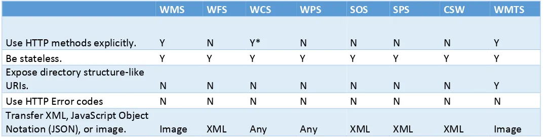
A quick analysis of the existing OGC standards shows that there is still some work to be done to align to the REST tips described above.
Table 1 – Cross-reference of OGC standards to REST practices
WMS WFS WCS WPS SOS SPS CSW WMTS
Use HTTP methods explicitly. Y N Y* N N N N Y
Be stateless. Y Y Y Y Y Y Y Y
Expose directory structure-like
URIs. N N N N N N N Y
Use HTTP Error codes N N N N N N N N Transfer XML, JavaScript Object
Notation (JSON), or image. Image XML Any Any XML XML XML Image
6.1 Analysis of REST Initiatives within OGC
6.1.1 Geoservices REST – Overview
The GeoServices REST Specification provides a standard way for web clients to communicate with geographic information system (GIS) servers through
Copyright © 2016 Open Geospatial Consortium. 17 allowed its implementation by others outside the Esri platform. The specification was then worked processed as a candidate OGC standard in the GeoServices SWG. The draft version of the candidate is available. The candidate standard specifies commonly used resources in an implementation of the GeoServices REST API as well as extensibility requirements.
The GeoServices REST Specification describes a catalog of web services that are
designed for different GIS functions (map, geocode, and so on). The GeoServices REST API specification document has been structurally broken down into multiple documents. An implementer interested in implementing feature services, would only need to
understand the core, the catalog spec and the Feature service spec to fully implement the GeoServices Feature Service. The Core and the catalog spec provides the overall services viewpoint, while the feature services doc (part 4) talks specifically to the feature service related functionality.
Part 1 : Core Part 2 : Catalog Part 3 : Map Service Part 4: Feature Service Part 5: Geometry Service Part 6: Image Service
Part 7: Geoprocessing Service Part 8: Geocoding Service
6.1.2 Why implement the GeoServices REST specification?
18 Copyright © 2016 Open Geospatial Consortium.
6.1.3 How to implement the GeoServices REST specification.
To implement the GeoServices REST Specification, developers architect the back-end server to respond to specifically structured REST requests in an expected way. For example, if someone issues a request to the server to export a map image, such as http://<mapservice-url>/export?bbox=-127.8,15.4,-63.5,60.5, the server should return a map image with a lower left coordinate of (-127.8, 15.4) and an upper right coordinate of (-63.5, 60.5). How the server generated the image is not as important as the fact that it responded in an expected way when issued a URL whose structure followed the GeoServices REST Specification.
The full GeoServices REST Specification is described in the OGC candidate standard documents. Developers can choose how much or how little to implement. For example, if geocoding or geoprocessing operations are not exposed by the GIS server, developers may not need to implement the Geocode Service or GP Service piece of the candidate standard.
All resources and operations exposed by the GeoServices REST Specification are
accessible through a hierarchy of endpoints or uniform resource locators (URLs) for each available GIS service. When using the GeoServices REST Specification, users typically start from a well-known endpoint, which represents the server catalog. From the catalog, different types of resources are available as child nodes. These resources comprise services for mapping, geocoding, and so on.
The GeoServices REST Specification is stateless because REST does not keep track of transactions from one request to the next. Each request must contain all the information necessary for successful processing.
6.1.4 Resources and Operations
The GeoServices REST Specification works with a hierarchy of resources. Each service type recognized by the GeoServices REST Specification (map, geocode, and so on) is a resource and has a unique URL. Although a REST system always returns only
representations of resources to client, for the sake of simplicity, the resources of the GeoServices REST Specification are divided into two types: resources and operations (also called controller resources).
6.1.5 Response Formats
Copyright © 2016 Open Geospatial Consortium. 19 various data formats, including JSON, HTML, and KMZ. Current implementations of the spec by Esri also support GeoJSON as an additional JSON based format.
At the least, the JSON response format should be implemented, and examples for doing so are provided in the specification. Other formats are optional, and they can be exposed through the f parameter; however, formats other than JSON are not detailed in the specification.
6.1.6 REST and Pragmatic Considerations
The GeoServices REST specification is based on both RESTful principles and pragmatic considerations. These considerations include – support for various aspects of the HTTP protocol in commonly used environments like JavaScript, Adobe Flex or Microsoft Silverlight, in commonly used web browsers, and in proxys. Many of these environments do not typically offer complete support for all of the HTTP standard. This lead the
initiators of the GeoServices REST specification to make some choices. Here are some of the pragmatic considerations.
- Certain web browsers lack support for HTTP PUT and DELETE (except using scripting methods).
- Some rich internet application clients do not fully support PUT and DELETE.
- From a practical implementation standpoint from within the browser for HTML applications one may want to use HTTP GETs via dynamic script tags whenever this can be done safely. Dynamic script tags for GET operations are cacheable and do not force clients on different domains to go through a proxy.
- HTTP POST is needed whenever the size of the URL may be longer than 2048 characters. This isn’t usually a factor for most API designs, but in the context of geographic information it happens quite frequently (serialized geometries can easily be larger than 2000 characters).
- Often firewalls and proxies strip out HTTP PUTs and DELETEs. This can be mitigated by forcing SSL for all requests, but this is not practical. Some RESTful APIs recommend HTTP method overloading to get around this, which would be a hack. In this case one would use POST, but in the header (or in the query parameter) one specifies that one really wants to do a PUT or DELETE.
- Cross domain scripting needs have been mostly solved using proxy servers and support for JSONP (JSON with padding). These make it impossible to support all the HTTP error codes. As discussed in Clause 8, most responses with JSON content will use an HTTP status code 200 and the JSON content will either be a resource
representation, the result of a controller resource operation or an exception.
- MIME types are advertised using query parameters in the URL (e.g., “?f=json”) rather than using the HTTP headers. This too can be attributed to the fact that many times proxy servers tend to strip out header information and hence a more
20 Copyright © 2016 Open Geospatial Consortium.
6.1.7 Summary
As part of the GeoServices REST API SWG process, there were many issues that were seriously considered. A good review of these comments will provide an expanded view of a) REST as a pattern for geospatial web services, b) Pragmatic considerations that are necessary for creating “real world” implementations using REST and c) the synergies that exist between the GeoServices model and the ISO/OGC Baseline.
Some sample URL’s from Esri’s implementation of the open GeoServices REST
specification are provided below. These are rich examples for readers of the ER to review and play with to better understand the value of the GeoServices REST specification. As the OGC document is still a draft, the sample implementations below are not “fully compliant” implementations of the OGC candidate standard.
http://sampleserver1.arcgisonline.com/ArcGIS/rest/services http://sampleserver2.arcgisonline.com/ArcGIS/rest/services http://sampleserver3.arcgisonline.com/ArcGIS/rest/services http://sampleserver4.arcgisonline.com/ArcGIS/rest/services http://sampleserver5.arcgisonline.com/ArcGIS/rest/services http://sampleserver6.arcgisonline.com/ArcGIS/rest/services
The OGC SWG group for the GeoServices SWG is currently inactive. In the future the SWG may decide to restart its activities to take this process to completion; making the candidate standard a full OGC standard. Until then, the work that went into this effort holds many answers for the other OGC activities seeking to leverage RESTful patterns. Web environments today increasingly favor patterns that reflect the natural evolution of the web over rigid academic design arguments. The candidate standard finely balances the rigor necessary for standardization with the practical aspects of building a GIS experience that stays faithful to practical Web 2.0 principles.
6.1.8 Further References
Draft OGC document: GeoServices REST API – Part 1-8 (OGC -12-054r1) GeoServices REST API – Relationship with the OGC standards baseline (OGC 12-062r2)
GeoServices REST API – JSON Schemas and Examples (OGC 12-068r2) GeoServices REST API – RFC Comments (OGC 12-164)
GeoServices REST specification ( published by Esri):
Copyright © 2016 Open Geospatial Consortium. 21
6.2 WaterML 2.0 API
Very recently, the WaterML SWG presented a REST interface and JSON encoding for WaterML 2.0 (OGC 15-033 – OGC WaterML2.0 part 2 – RESTful API and JSON encoding) Best Practice document –. The document specifies a RESTful API and JSON encoding of WaterML2.0 part 2. This API and encoding was used in the part 2
Interoperability Experiment (IE) to test the information model. The implementation was found to be useful for the IE participants and thus has been documented as a best
practice.
The RESTful API design was based on the requirements outlined by the IE participants and through an iterative implementation. The Best Practice scope is based on the WaterML2.0 information model. There are parts of the implementation that would require harmonization with any future OGC-wide RESTful and JSON practices.
In the case of the Best Practice document, it is a read-only service, so it only used GET. With the exception of plurals for resource in path, this API follows the guidelines described above.
The WaterML2 REST API (http://waterml2.csiro.au/rgs-api/v1/) is very simple as it defines the resources that can be managed at the root URL and it uses links extensively so that HATEOAS principle can be applied.
The available documentation is also very easy to understand and interactive. The most noticeable difference of this API compared to other OGC initiatives is that is starts from the Resources, which is the logical path for a REST API.
22 Copyright © 2016 Open Geospatial Consortium.
6.3 Web Map Tile Service (WMTS) RESTful binding
One of the first OGC standards that adopted REST principles was WMTS. Inspired in the previous community standard called TMS, WMTS adopted some of the RESTful
Copyright © 2016 Open Geospatial Consortium. 23 One of the particularities of WMTS is that it uses the URL template standard to specify a URL pattern that all tile and FeatureInfo URL follows. The URL template standard extends the URL standard to allow to specify parameter names between ‘{‘and‘}’ that will be processed by the client and substituted by actual values. This way, with a single URL template the client is able to create a URL of the needed tile (or a FeatureInfo) and retrieve a representation using a GET request. Even if this patter is also adopted in OpenSearch, the use of URL template has raised criticism.
6.3.1 Criticism of the URL template approach.
There are two criticisms of the URL template approach. The first is that URL templates are not opaque but follow some predefined structure. The second criticism is that this means of link navigation is not entirely consistent with HATEOAS principles. In a completely RESTful HATEOAS implementation of a tile service, the service
metadata document would point to a single tile that includes the whole extent provided by the layer. The tile format would be a text format that includes URL links to the tiles in the next level and the tile image linked or embedded (an alternative to this is use HTTP headers as specified in Clause 5. If the client requested a tile from the next zoom level, the response would provide new URL links to the spatially adjacent neighbors and the next higher and lower zoom levels. In this approach clients would have all the
information to navigate through resources without previous knowledge of the tile URL pattern.
In practice, this has proven to result in remarkably awkward map applications. The client still needs to know crucial information about the individual tiles and tile hierarchy. The client needs to know something about the geospatial position of each tile. Otherwise, the client will not be able arrange the tiles adequately in the viewport and to cut out the unwanted regions of the marginal tiles. Crawling through a set of tiles in order to compute how to arrange them is just painful. Another factor to take into account is that sometimes users will require jumping from one zoom level to another that is far from the current one or will request a completely new location far from the previous view. In this case the status information that the server can communicate to the client in each tile in the form of new links becomes impractical. As a general principle, we think that the
geospatial component introduces implicit geospatial relations between tiles that clients need to know in advance and exploit to provide a good user experience. These geospatial relations / templates cover the functionality that HATEOAS might provide step-by-step but with the necessary added efficiency of being able to request only the needed tiles out of possibly millions of possibilities.
6.3.2 Caching and considerations for future parameter extensions.
24 Copyright © 2016 Open Geospatial Consortium. Some people argue that the KVP approach commonly used in OGC standards is also RESTful. This has some merit, but there are drawbacks. KVP is too flexible and allows for any order in the parameters. In addition, some standards allow for floating point numbers in KVP values associated to some keys (e.g. the BBOX). When combined this opens the door to an almost infinite number of URL variants for the same resource and makes efficient caching almost impossible.
The way WMTS is defined requires specifying all possible values of any new extra dimension in the service metadata document. The goal is to ensure that the values of these parameters will be written in the URLs in a single form with no ambiguity (the same provided by the service metadata document).
Recently, a WMTS time extension has been proposed. The proposers of the extension argue that listing all time values in the service metadata document is not convenient for long time series, and want to provide just an interval. This creates ambiguity in the way time has to be written in the URL depending on the precision used by the client. To prevent multiple URLs pointing to the same resource a format template is proposed. This is an extension of the URL template standard that will allow providing a format pattern. A example of what it has been proposed is: {time:YYYY/MM/DDThh:mm} where YYYY represents the year, MM represents the month, DD represents the day, hh
represents the hour and mm represents the minutes (as used in some software such as MS Excel). In our opinion, this can be also used for other future parameter extensions such as elevation or temperature in the same way: {elevation:###00} or {temperature:##.#} where # represents a digit.
The need for having a single URL (or at least a small number) pointing to each resource needs to be taken into account in any WMTS extension.
6.3.3 WMTS Simple
The WMTS simple profile has been tested during the Testbed 11 activity. WMTS simple makes RESTful binding mandatory and imposes one of the two possible TileMatrixSets defined in the standard. A client using WMTS simple profile can ignore the Service Metadata document of a WMTS service conformant to this profile. Service discovery is made possible by communicating the URL template of a layer in the WMTS service directly by any communication means such as Facebook, Twitter, or an email. The following email fragment illustrates how this can be done.
Hey,
I have a WMTS 1.0.0 service up at “http://mycompany.com/wmts”. It can be accessed with a standard WMTS client application. It’s also compatible with the WMTS-Simple profile, with the following URL templates:
“Oceans” layer:
Copyright © 2016 Open Geospatial Consortium. 25
The “Transportation” layer (Rand-McNally style):
http://mycompany.com/wmts/1.0.0/tiles/transportation/RandMcNally/ smerc/{TileMatrix}/{TileCol}/{TileRow}.png
By implementing this profile, clients can more easily combine data coming from different services including from other WMTS instances and even from some tile implementations that are not OGC WMTS based, such as some current distributions of Open Street Map (OSM). In fact, most of these tiling services are implicitly following most of the WMTS requirements without saying it.
Even if the simple profile makes REST binding mandatory, it is questionable if it is more RESTFul than the previous version of WMTS. By imposing this profile, the client status description becomes simpler due to the TileMatrixSet si fixed. Nevertheless, clients do not exchange the status with services in HATEOAS way either.
6.4 REST binding for WFS 2.5
6.4.1 Introduction
The forthcoming WFS 2.5 specification includes a REST binding that, unlike existing OGC standards which are service-oriented, is a resource-oriented description of a web feature server that uses the standard HTTP interface as meaningfully as possible to manipulate and manage feature resources.
Testbed 11 provided an opportunity to test web feature services implementing the REST binding as described in the WFS 2.5 implementation standard. This clause summarizes the salient elements of the RESTful web features services used, primarily in the Urban-Climate Resilience thread, during the OGC Testbed 11 and described in OGC 11-080r1. 6.4.2 Basic service elements
6.4.2.1 Service root
For interactions with a RESTful WFS to commence a client needs to discover the service root of the WFS. The format of the service root URL is not specified in the WFS 2.5 standard and as such alleviates the need to define service and version negotiation protocols as those elements may (or not) be incorporated into the published service root URL in any manner that is meaningful to the service implementation.
The following table lists the service roots for the RESTful WFSs used in the OGC Testbed 11.
Table 2 – OGC Testbed 11 WFS 2.5 Implementations
26 Copyright © 2016 Open Geospatial Consortium. CubeWerx 6.4.2.1.1.1.1.1http://www.pvretano.com/cubewerx/cubeserv/default/wfs/2.5
.0/ows11
Geomatys http://ows11.geomatys.com/constellation/WS/wfs/MOZOSM/2.0.0 IBM http://ogcwfs.mybluemix.net/wfs/2.5
A WFS’s service metadata document (i.e. its capabilities document) (see OGC 06-121r3, OGC 11-080r1) is accessible at its service root.
6.4.2.2 Representation of features
The canonical representation of features, as defined in the WFS 2.5 standard, is GML 3.2 (see OGC 07-036). However, the standard allows other representation to be used as well and during Testbed 11 extensive testing was undertaken using a JSON, and specifically GeoJSON (see http://geojson.org/geojson-spec.html) representation of features.
6.4.2.3 Content negotiation
Content negotiation is the mechanism by which a client or user agent and a server arrive at a mutually agreeable representation of resources in the server’s response. During Testbed 11, two approaches to content negotiation were tested.
The primary method of content negotiation used in the OGC Testbed 11 was the HTTP Accept header (see http://www.w3.org/Protocols/rfc2616/rfc2616-sec14.html). In a WFS request, the client simply sets the value of the Accept header to a list of one or more MIME types representing the client’s preferred resources encodings. Each listed MIME type may also include a quality factor letting the server know the relative degree of preference of each listed MIME type. The following as examples of the Accept header indicating the client’s preferences for a GeoJSON feature representation but also capable of accepting a GML representation:
Accept : application/vnd.geo+json, application/gml+xml ; version=3.2
In the absence of quality factors the MIME types are listed in preferred representation first.
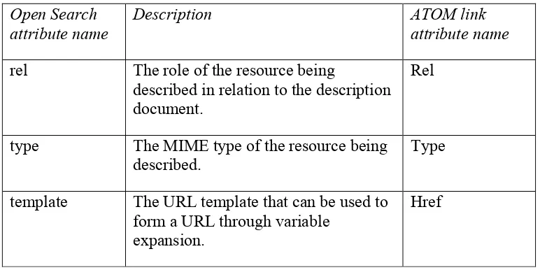
6.4.2.4 Hypermedia controls
Copyright © 2016 Open Geospatial Consortium. 27 The ATOM link element includes a “rel” attribute describing the relationship between the current document and the linked document. The value of the “rel” attribute can be a value from the IANA Link Relations registry (see RFC 5988) or a value that has been registered with the OGC naming authority.
The two primary places where hypermedia controls can appear in a WFS’s response are in the server’s capabilities document and in a query response.
Hypermedia controls in the server’s capabilities document allow a client to:
(a) Obtain the application schema that the service offers. This schema must be available as a GML 3.2 (see OGC 07-036) application schema but other schema representations are allowed.
(b) Navigate to a collection of features of this type. (c) Obtains the schema of this feature type.
(d) Access (i.e. query) features of this feature type.
The following XML fragments is an example from the capabilities document of one of the servers using in Testbed 11:
<FeatureType>
<atom:link xmlns:atom=”http://www.w3.org/2005/Atom” rel=”collection”
href=”http://www.pvretano.com/cubewerx/cubeserv/default/wfs/2.5.0 /ows11/wwAccess”/>
<atom:link xmlns:atom=”http://www.w3.org/2005/Atom” rel=”describedby” type=”application/schema+xml”
href=”http://www.pvretano.com/cubewerx/cubeserv/default/wfs/2.5.0 /ows11/wwAccess”/>
<Name>cw:wwAccess</Name> <Title>wwAccess</Title>
<DefaultCRS>urn:ogc:def:crs:EPSG::4326</DefaultCRS> <OtherCRS>urn:ogc:def:crs:EPSG::42110</OtherCRS> <OtherCRS>urn:ogc:def:crs:EPSG::3857</OtherCRS> <OtherCRS>urn:ogc:def:crs:EPSG::4267</OtherCRS> <OtherCRS>urn:ogc:def:crs:EPSG::4269</OtherCRS> <OtherCRS>urn:ogc:def:crs:EPSG::32758</OtherCRS> <OtherCRS>urn:ogc:def:crs:EPSG::32759</OtherCRS> <OtherCRS>urn:ogc:def:crs:EPSG::32760</OtherCRS> <OtherCRS>urn:ogc:def:crs:OGC::CRS41001</OtherCRS> <ows:WGS84BoundingBox>
<ows:LowerCorner>172.4565 -43.8190</ows:LowerCorner> <ows:UpperCorner>172.9755 -43.3975</ows:UpperCorner> </ows:WGS84BoundingBox>
</FeatureType>
28 Copyright © 2016 Open Geospatial Consortium. The first control, with rel=”collection”, will access features of this this type by
performing a query on the server using the default values of the query parameters (see Table 4). In this case, the control is a link to a document that contains 10 features (the default value for the “count” parameter) of the “wwAccess” type.
The second control, with rel=”describedby”, accesses a document containing the schema of the feature type wwAccess.
In this way, a client (knowing the service root) can navigate to next, valid, states without necessarily having to be aware of the details of accessing the service. The only
requirement is that the client recognizes the “rel” value and resolves the accompanying link.
Hypermedia controls in a query response may allow a client to:
(a) Navigate to the service (i.e. get its capabilities document) that offers the feature. (b) Navigate to the collection that contains the feature.
(c) Navigate to alternative representations of the current feature
The following XML fragment shows a sample query response with hypermedia controls:
<wfs:member>
<atom:link rel=”service”
href=”http://www.pvretano.com/cubewerx/cubeserv/default/wfs/2.5.0/ows11 ”/>
<atom:link rel=”collection”
href=”http://www.pvretano.com/cubewerx/cubeserv/default/wfs/2.5.0/ows11 /wwAccess”/>
<atom:link rel=”alternate” type=”application/gml+xml; version=2.1” href=”http://www.pvretano.com/cubewerx/cubeserv/default/wfs/2.5.0/ows11 /wwAccess/CWFID.WWACCESS.0.0.BA89DF77E5626F761F20020000?outputFormat=ap plication%2Fgml%2Bxml%3B%20version%3D2.1”/>
<atom:link rel=”alternate” type=”application/gml+xml; version=3.1” href=”http://www.pvretano.com/cubewerx/cubeserv/default/wfs/2.5.0/ows11 /wwAccess/CWFID.WWACCESS.0.0.BA89DF77E5626F761F20020000?outputFormat=ap plication%2Fgml%2Bxml%3B%20version%3D3.1”/>
<atom:link rel=”alternate” type=”application/gml+xml; version=3.2” href=”http://www.pvretano.com/cubewerx/cubeserv/default/wfs/2.5.0/ows11 /wwAccess/CWFID.WWACCESS.0.0.BA89DF77E5626F761F20020000?outputFormat=ap plication%2Fgml%2Bxml%3B%20version%3D3.2”/>
<atom:link rel=”alternate” type=”application/x-bxfs+xml; version=0.0.3”
href=”http://www.pvretano.com/cubewerx/cubeserv/default/wfs/2.5.0/ows11 /wwAccess/CWFID.WWACCESS.0.0.BA89DF77E5626F761F20020000?outputFormat=ap plication%2Fx-bxfs%2Bxml%3B%20version%3D%220.0.3%22”/>
<atom:link rel=”alternate” type=”application/rss+xml”
href=”http://www.pvretano.com/cubewerx/cubeserv/default/wfs/2.5.0/ows11 /wwAccess/CWFID.WWACCESS.0.0.BA89DF77E5626F761F20020000?outputFormat=ap plication%2Frss%2Bxml”/>
<atom:link rel=”alternate” type=”application/vnd.google-earth.kml+xml”
Copyright © 2016 Open Geospatial Consortium. 29
/wwAccess/CWFID.WWACCESS.0.0.BA89DF77E5626F761F20020000?outputFormat=ap plication%2Fvnd.google-earth.kml%2Bxml”/>
<atom:link rel=”alternate” type=”application/atom+xml”
href=”http://www.pvretano.com/cubewerx/cubeserv/default/wfs/2.5.0/ows11 /wwAccess/CWFID.WWACCESS.0.0.BA89DF77E5626F761F20020000?outputFormat=ap plication%2Fatom%2Bxml”/>
<atom:link rel=”alternate” type=”text/html”
href=”http://www.pvretano.com/cubewerx/cubeserv/default/wfs/2.5.0/ows11 /wwAccess/CWFID.WWACCESS.0.0.BA89DF77E5626F761F20020000?outputFormat=te xt%2Fhtml”/>
<atom:link rel=”alternate” type=”application/vnd.geo+json”
href=”http://www.pvretano.com/cubewerx/cubeserv/default/wfs/2.5.0/ows11 /wwAccess/CWFID.WWACCESS.0.0.BA89DF77E5626F761F20020000?outputFormat=ap plication%2Fvnd.geo%2Bjson”/>
<atom:link rel=”alternate” type=”application/vnd.shp+octet-stream” href=”http://www.pvretano.com/cubewerx/cubeserv/default/wfs/2.5.0/ows11 /wwAccess/CWFID.WWACCESS.0.0.BA89DF77E5626F761F20020000?outputFormat=ap plication%2Fvnd.shp%2Boctet-stream”/>
<wwAccess
gml:id=”CWFID.WWACCESS.0.0.BA89DF77E5626F761F20020000”> <Geometry>
<gml:Point gml:id=”GID1”
srsName=”urn:ogc:def:crs:EPSG::4326”>
<gml:pos>-43.59451450970821 172.5609996851931</gml:pos> </gml:Point>
</Geometry>
<uid>WWMH-3044</uid>
<AccessType>Standard Manhole</AccessType> <SourceId>2504S00145</SourceId>
<LocationCe>Non Verified</LocationCe> <NearestPru>1</NearestPru>
<HansenId>62682</HansenId> <n>5734677.7</n>
<e>2474562.44</e>
<WwAccessID>3044</WwAccessID> <Compkey>9521</Compkey>
<HeightAbov>22.04</HeightAbov> <Constructi>1</Constructi> <Depth>1.1</Depth>
<Maintenanc>City Water and Waste</Maintenanc> <ServiceSta>Abandoned</ServiceSta>
<Decommissi>2013-04-30</Decommissi> <YearLaid>1971-01-01</YearLaid>
<SAPInterna>IE000000000010739686</SAPInterna> <LastEditDa>2015-01-26</LastEditDa>
<LastEditUs>CCITY\TredinnickC</LastEditUs> <WwAccessSt>3453</WwAccessSt>
<Checked>0</Checked> </wwAccess>
</wfs:member>