Open Geospatial Consortium Inc.
Date:2007-12-14
Reference number of this document:OGC 07-018r2
Version: 0.9.5
Category: OGC Best Practice paper
Editor:Philippe Mérigot, Spot Image
OpenGIS
®Sensor Planning Service Application Profile
for EO Sensors
Copyright
Copyright © 2008 Open Geospatial Consortium, Inc. All Rights Reserved. To obtain additional rights of use, visit http://www.opengeospatial.org/legal/.
Warning
This document defines an OGC Best Practices on a particular technology or approach related to an OGC standard. This document is not an OGC Standard and may not be referred to as an OGC Standard. It is subject to change without notice. However, this document is an official position of the OGC membership on this particular technology topic.
License Agreement
Permission is hereby granted by the Open Geospatial Consortium, ("Licensor"), free of charge and subject to the terms set forth below, to any person obtaining a copy of this Intellectual Property and any associated documentation, to deal in the Intellectual Property without restriction (except as set forth below), including without limitation the rights to implement, use, copy, modify, merge, publish, distribute, and/or sublicense copies of the Intellectual Property, and to permit persons to whom the Intellectual Property is furnished to do so, provided that all copyright notices on the intellectual property are retained intact and that each person to whom the Intellectual Property is furnished agrees to the terms of this Agreement.
If you modify the Intellectual Property, all copies of the modified Intellectual Property must include, in addition to the above copyright notice, a notice that the Intellectual Property includes modifications that have not been approved or adopted by LICENSOR.
THIS LICENSE IS A COPYRIGHT LICENSE ONLY, AND DOES NOT CONVEY ANY RIGHTS UNDER ANY PATENTS THAT MAY BE IN FORCE ANYWHERE IN THE WORLD.
THE INTELLECTUAL PROPERTY IS PROVIDED "AS IS", WITHOUT WARRANTY OF ANY KIND, EXPRESS OR IMPLIED, INCLUDING BUT NOT LIMITED TO THE WARRANTIES OF MERCHANTABILITY, FITNESS FOR A PARTICULAR PURPOSE, AND NONINFRINGEMENT OF THIRD PARTY RIGHTS. THE COPYRIGHT HOLDER OR HOLDERS INCLUDED IN THIS NOTICE DO NOT WARRANT THAT THE FUNCTIONS CONTAINED IN THE INTELLECTUAL PROPERTY WILL MEET YOUR REQUIREMENTS OR THAT THE OPERATION OF THE INTELLECTUAL PROPERTY WILL BE UNINTERRUPTED OR ERROR FREE. ANY USE OF THE INTELLECTUAL PROPERTY SHALL BE MADE ENTIRELY AT THE USER’S OWN RISK. IN NO EVENT SHALL THE COPYRIGHT HOLDER OR ANY CONTRIBUTOR OF INTELLECTUAL PROPERTY RIGHTS TO THE INTELLECTUAL PROPERTY BE LIABLE FOR ANY CLAIM, OR ANY DIRECT, SPECIAL, INDIRECT OR CONSEQUENTIAL DAMAGES, OR ANY DAMAGES WHATSOEVER RESULTING FROM ANY ALLEGED INFRINGEMENT OR ANY LOSS OF USE, DATA OR PROFITS, WHETHER IN AN ACTION OF CONTRACT, NEGLIGENCE OR UNDER ANY OTHER LEGAL THEORY, ARISING OUT OF OR IN CONNECTION WITH THE IMPLEMENTATION, USE, COMMERCIALIZATION OR PERFORMANCE OF THIS INTELLECTUAL PROPERTY.
This license is effective until terminated. You may terminate it at any time by destroying the Intellectual Property together with all copies in any form. The license will also terminate if you fail to comply with any term or condition of this Agreement. Except as provided in the following sentence, no such termination of this license shall require the termination of any third party end-user sublicense to the Intellectual Property which is in force as of the date of notice of such termination. In addition, should the Intellectual Property, or the operation of the Intellectual Property, infringe, or in LICENSOR’s sole opinion be likely to infringe, any patent, copyright, trademark or other right of a third party, you agree that LICENSOR, in its sole discretion, may terminate this license without any compensation or liability to you, your licensees or any other party. You agree upon termination of any kind to destroy or cause to be destroyed the Intellectual Property together with all copies in any form, whether held by you or by any third party.
Except as contained in this notice, the name of LICENSOR or of any other holder of a copyright in all or part of the Intellectual Property shall not be used in advertising or otherwise to promote the sale, use or other dealings in this Intellectual Property without prior written authorization of LICENSOR or such copyright holder. LICENSOR is and shall at all times be the sole entity that may authorize you or any third party to use certification marks, trademarks or other special designations to indicate compliance with any LICENSOR standards or specifications.
This Agreement is governed by the laws of the Commonwealth of Massachusetts. The application to this Agreement of the United Nations Convention on Contracts for the International Sale of Goods is hereby expressly excluded. In the event any provision of this Agreement shall be deemed unenforceable, void or invalid, such provision shall be modified so as to make it valid and enforceable, and as so modified the entire Agreement shall remain in full force and effect. No decision, action or inaction by LICENSOR shall be construed to be a waiver of any rights or remedies available to it.
Contents
Pagei. Preface ... viii
ii. Document terms and definitions ... viii
iii. Submitting organizations ... viii
iv. Document contributor contact points ... ix
v. Revision history ... ix
vi. Changes to the OGC Abstract Specification ... x
vii. Future work ... x
viii. Open issues ... xiii
ix. Foreword ... xiii
1. Scope ... 1
2. Conformance ... 1
3. References ... 2
3.1. Normative references ... 2
3.2. Other references ... 3
4. Terms and definitions ... 3
5. Symbols and abbreviations ... 6
5.1. Symbols (and abbreviated terms) ... 6
5.2. UML notation ... 8
5.2.1. UML Class Diagrams ... 8
5.2.2. UML Sequence Diagrams ... 9
5.3. XML notation ... 10
5.4. Document terms and definitions ... 11
6. System context ... 12
6.1. Application domain ... 12
6.2. Reference scenarios ... 13
7. SPS Overview ... 14
7.1. External interfaces ... 15
7.1.1. Imported protocol bindings (relationship with SPS implementation specification [NR13]) ... 15
7.1.2. Operations interface ... 16
8. Shared aspects ... 17
8.1. Unit of Measure ... 17
8.2. notificationTarget versus WS-Addressing (asynchronous operations) ... 17
8.3. Acknowlegments ... 18
8.3.1. Request acknowledgment schema ... 19
8.3.2. Response acknowledgment status ... 20
8.4. Progress reports ... 21
8.5. Report type ... 22
9. Information models for EO Programming Requests ... 24
9.1.1. EO profile specific ... 25
9.5. Preliminary List of Tasking Parameters ... 29
9.5.1. Priority ... 30
9.5.2. Acquisition parameters ... 30
9.5.3. GeometricCoverageCharacteristics ... 33
9.5.4. RegionOfInterest ... 33
9.5.5. ValidationParameters ... 34
9.5.6. SurveyPeriods type ... 34
9.5.7. Period type ... 36
9.5.8. Incidence angle type ... 36
10. GetCapabilities operation (mandatory, synchronous) ... 37
10.1. Introduction ... 37
10.2. EO profile specific ... 37
10.3. Capabilities schema ... 37
10.4. GetCapabilities Operation request ... 37
10.5. GetCapabilities Operation response ... 38
10.5.1. Normal response ... 38
10.5.2. OperationsMetadata section standard contents ... 39
10.6. Exceptions ... 40
10.7. Examples ... 40
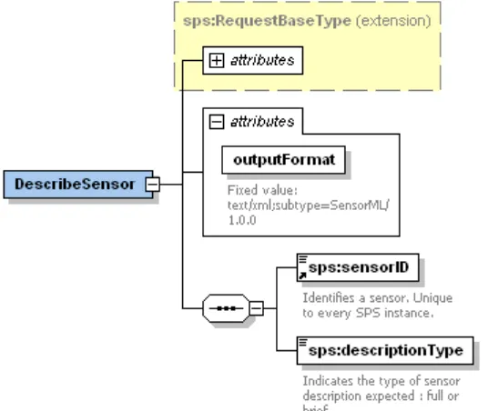
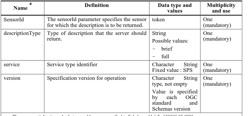
11. Describe Sensor operation (mandatory, synchronous) ... 42
11.1. Introduction ... 42
11.2. EO profile specific ... 42
11.3. DescribeSensor operation request ... 42
11.4. DescribeSensor operation response ... 43
11.5. Exceptions ... 43
11.6. Examples ... 43
12. EstimateSensorWorkload operation (optional, synchronous) ... 44
12.1. EO profile specific ... 44
12.2. EstimateSensorWorkload operation request ... 44
12.3. EstimateSensorWorkload operation response ... 45
12.4. Exceptions ... 45
12.5. Examples ... 45
13. DescribeGetFeasibility operation (optional, synchronous) ... 46
13.1. Introduction ... 46
13.2. EO profile specific ... 46
13.3. DescribeGetFeasibility operation request ... 46
13.4. DescribeGetFeasibility operation response ... 47
13.5. Exceptions ... 48
13.6. Examples ... 48
14. DescribeSubmit operation (mandatory, synchronous) ... 49
14.1. Introduction ... 49
14.3. DescribeSubmit operation request ... 49
14.4. DescribeSubmit operation response ... 50
14.5. Exceptions ... 51
14.6. Examples ... 51
15. GetFeasibility and Submit operations ... 52
15.1. EO profile specific use cases ... 52
15.2. GetFeasibility operation (optional, asynchronous) ... 55
15.2.1. Introduction ... 55
15.2.2. EO profile specific ... 56
15.2.3. GetFeasibility request ... 56
15.2.4. GetFeasibility request acknowledgment ... 58
15.2.5. GetFeasibility response ... 58
15.2.6. GetFeasibility response acknowledgment ... 60
15.2.7. Exceptions ... 60
15.2.8. Examples ... 60
15.3. Submit operation (mandatory, asynchronous) ... 61
15.3.1. Introduction ... 61
15.3.2. EO profile specific ... 61
15.3.3. Submit request ... 63
15.3.4. Submit request acknowledgement ... 64
15.3.5. Submit response ... 64
15.3.6. Submit response acknowledgment ... 64
16. GetStatus operation (optional, synchronous) ... 65
16.1. Introduction ... 65
16.2. EO profile specific ... 65
16.3. GetStatus operation request ... 65
16.4. GetStatus operation response ... 66
16.5. Exceptions ... 66
16.6. Examples ... 66
17. Update operation (optional, synchronous) ... 68
17.1. Introduction ... 68
17.2. Update operation request ... 68
17.3. Update operation response ... 69
17.4. Exceptions ... 69
17.5. Examples ... 70
18. Cancel operation (optional, asynchronous) ... 71
18.1. Introduction ... 71
18.2. EO profile specific ... 71
18.3. Cancel request ... 71
18.4. Cancel request acknowledgment ... 72
18.5. Cancel response ... 72
18.6. Cancel response acknowledgement ... 73
18.7. Exceptions ... 73
18.8. Examples ... 73
19. DescribeResultAccess operation (mandatory, synchronous) ... 74
19.1. Introduction ... 74
19.2. EO profile specific ... 74
19.3. DescribeResultAccess operation request ... 74
19.5. Exceptions ... 76
19.6. Examples ... 76
20. Multi provider scenario ... 77
20.1. sensorID scenario ... 77
20.2. DescribeGetFeasibility scenario ... 77
20.3. GetFeasibility scenario ... 78
20.4. Submit scenario ... 79
20.5. GetStatus scenario ... 80
Annex A (normative) XML schema documents ... 81
A.1 spsGetCapabilities.xsd ... 81
A.2 spsDescribeSensor.xsd ... 82
A.3 spsDescribeGetFeasibility.xsd ... 83
A.4 spsGetFeasibility.xsd ... 83
A.5 spsDescribeSubmit.xsd ... 85
A.6 spsSubmit.xsd ... 86
A.7 spsGetStatus.xsd ... 89
A.8 spsCancel.xsd ... 89
A.9 spsUpdate.xsd ... 90
A.10 spsDescribeResultAccess.xsd ... 91
A.11 spsCommon.xsd ... 92
A.12 spsContents.xsd ... 96
A.13 gml4sps.xsd ... 98
Annex B (informative) Example of XML documents ... 99
B.1 DescribeSubmit operation example ... 99
B.2 GetFeasibility operation examples ... 100
B.2.1 Example of GetFeasibility request ... 100
B.2.2 Example of GetFeasibility request acknowledgment ... 101
B.2.3 Example of GetFeasibility response ... 101
B.3 DescribeSensor operation examples ... 102
B.3.1 Example of brief description (SPOT 10 meter 4 bands): ... 102
B.3.2 Example of complete description (SPOT 5 HRS): ... 105
B.4 Examples of SOAP Synchronous messages ... 113
List of figures
Figure 3-1 UML notations... 8
Figure 3-2: UML Sequence Diagrams Notations. ... 9
Figure 8-1 - Request acknowledgment schema ... 19
Figure 8-2 - Response acknowledgement schema ... 20
Figure 8-3 - Progress report schema ... 21
Figure 9-1 – ParameterDescriptor ... 24
Figure 9-2 - InputParameter element diagram ... 26
Figure 9-3: DeliveryInformationType diagram. ... 27
Figure 9-4 - list of tasking parameters ... 29
Figure 9-5 - Capabilities schema ... 37
Figure 6 - DescribeSensor request schema ... 42
Figure 13-1: - DescribeGetFeasibility request schema ... 46
Figure 13-2: - DescribeGetFeasibility response schema ... 47
Figure 14-1 - DescribeSubmit request schema ... 49
Figure 14-2 - DescribeSubmit response schema ... 50
Figure 15-1: - SPS for Earth Observation Sensor: getFeasibility/Submit operations: scene use case 52 Figure 15-2: - SPS for Earth Observation Sensor: getFeasibility/Submit operations: coverage use case ... 52
Figure 15-3: - SPS for multi sensors: getFeasibility operation detailed coverage use case with invocation of the GS ... 53
Figure 15-4: - SPS for multi sensors: getFeasibility operation detailed coverage use case with invocation of the GS ... 53
Figure 15-5: - SPS for multi sensors getFeasibility operation: coverage use case ... 54
Figure 15-6 - GetFeasibility asynchronous communication model ... 55
Figure 15-7: - GetFeasibility request schema ... 56
Figure 15-8: - GetFeasibility response schema ... 58
Figure 9 - Submit asynchronous communication model ... 61
Figure 15-10: - Submit request schema ... 63
Figure 15-11 – Submit response schema ... 64
Figure 16-1: - GetStatus request schema ... 65
Figure 16-2: - GetStatus response schema ... 66
Figure 17-1 - Update request schema ... 68
Figure 17-2 - Update response schema ... 69
Figure 3 - Cancel asynchronous communication model ... 71
Figure 18-4 - Cancel request schema ... 71
Figure 19-1: - DescribeResultAccess request schema ... 74
Figure 19-2: - DescribeResultAccess response schema ... 75
Figure 20-1: Get Feasibility Scenario ... 78
Figure 20-2: Submit Scenario. ... 79
Figure 20-3: GetStatus Scenario ... 80
i.
Preface
This OGC Best Practice document explains how Sensor Planning Service is organised and implemented for the Earth Observation domain.
The final goal being to agree to a coherent set of interfaces for sending a programming request for EO products to support access to data from heterogeneous systems dealing with derived data
products from satellite based measurements of the earth‟s surface and environment.
This document has used the Implementation Specification for the Sensor Planning Service (SPS) 1.0 [OGC 05-089r3] as input.
ii.
Document terms and definitions
This document uses the specification terms defined in Subclause 5.3 of [OGC 05-008], which is based on the ISO/IEC Directives, Part 2, Rules for the structure and drafting of International Standards.
iii.
Submitting organizations
The following organisations will submit the original document or its revisions to an OGC® SPS Standards Working Group.
ESA – European Space Agency Spacebel s.a.
Astrium Spot Image
The editors would like to acknowledge that this work is the result of collaboration and review of many organizations and would like to thank for the comments and contributions from:
ASI
CNES
DLR Eumetsat
MDA
EUSC
iv.
Document contributor contact points
All questions regarding this document should be directed to the editor. Additional contributors are listed below:
Name Organization Contribution Email
Didier Giacobbo Spot Image Initial version didier.giacobbo <at> spotimage.fr JC Angulo Spot Image List and description of
input parameters ((§ 9.5)
jean-christophe.angulo <at> spotimage.fr Alexandre Robin Spot Image SensorML (profil,
examples)
alexandre.robin <at> spotimage.fr Daniele Marchionni DATAMAT OR11, Review and
comments
Daniele.marchionni <at> datamat.it Jolyon Martin ESA Review and comments Jolyon.Martin <at> esa.int
Patrick Floissac Magellium (CNES sub contractor)
Review and comments Patrick.floissac <at> magellium.cnes.fr Ingo Simonis Geospatial Research
& Consulting
Review and comments ingo.simonis <at> geospatialresearch.de
v.
Revision history
Date Release Editor Primary clauses modified
Description
2006-07-28 0.0.1 Didier Giacobbo initial version initial version;
2006-09-04 0.0.2 Didier Giacobbo Small update Description of Simulated Sensor Workload and parameters to delegated mission plan added 2006-10-26 0.0.3 Didier Giacobbo Major update Add of new operations: DelegatedMissionPlan,
Update
Update of the XML example
Add of UML description for the EO aspects
2006-11-22 0.0.4 Philippe Mérigot Major update DescribeTasking replaced by DescribeGetFeasibility and DescribeSubmit.
Previous DescribeGetFeasibility removed. xxxRequestResponse renamed in xxxResponse Schemas modified: DescribeGetFeasibility, GetFeasibility, GetStatus
2006-12-21 0.9 Didier Giacobbo Major update HMA-IF-DAT-MP-0001_v1.0.3 merging 2007-01-12 0.9.1 Didier Giacobbo Minor update Editing correction
2007-01-16 0.9.1 Philippe Mérigot Major update viii Open issues Future work
XML examples modified: GetFeasibility & Submit request/response, sweCommon instance (annexe) 2007-02-07 0.9.2 Philippe Mérigot Major update Definition of acknowledgment messages for
asynchronous operations Input parameters:
AcquisitionMode possible values (OHR) ValidationParameters
SurveyPeriods
Op. modified: DescribeSubmit, Submit & GetStatus 2007-03-21 0.9.3 Philippe Mérigot Editing correction
Future work and open issues
Use of UML for the description of the preliminary list of input Parameters
GetCapabilities, DescribeSensor, GetFeasibility (feasibility levels) operations modified
DelegatedMissionPlan removed Delivery information removed
Schemas (annex A), SensorML examples (annex B) 2007-05-07 0.9.4 Philippe Mérigot Editing corrections
SOAP version 1.1 supported
Input parameters : parameter Priority
§ 21 (Implementation guidance) has been replaced by § 20 Multi provider scenario
Schemas: recursivity in Input parameters (§ 8.3), GML version (v3.1.1) and target namespace
Scenarios modified
New request response examples in Annex B 2007-10-08 0.9.5 Philippe Mérigot Major update - Reference to UM ICD
- OWS version 1.1.0
- Unit of measure: UCUM codes recommended - § 8 and 9 inverted and modified
- (IMPR#81) ProgrammingRequestMode parameter harmonised between SAR and OHR Operation - GetFeasibility : feasibility levels
- Cancel : asynchronous
- DescribeSensor response aligned with SOS - Shared requests and responses acknowledgement
(GetFeasibility, Submit, Cancel) - Progress reports
- Soap messages examples (annex B)
vi.
Changes to the OGC Abstract Specification
The OpenGIS® Abstract Specification does not require changes to accommodate the technical contents of this document.
vii.
Future work
In future versions of the document the following issues will be improved:
Regarding the ongoing revision work on the SPS specification, this current EO profile takes back the SPS specification as is it after the OWS4 initiative. Once an official version of the new SPS will be available (version 1.1), the SPS EO Profile will be updated in order to describe only the new operations and parameters.
operations are proposed only for this profile in order to fulfil the EO Sensor Planning Service requirements. Their adoption in the [OGC 05-089] document has to follow the OGC rules.
This profile is based on SOAP/WS-Addressing, which provides a convenient way for asynchronous notifications. But there is a lack about subscription (once specified in the request, the reception of notification messages cannot be cancelled or modified for example). Using SOAP/WS-Addressing with a WNS may be considered.
The parameters of the EstimateSensorWorkload operation have to be defined precisely. A complete schema applicable to this specification has to be provided.
The DescribeSensor operation returns two types of document (a complete and a brief description of the sensors), corresponding to two SensorML profiles. These profiles must be specified. The schema of the DescribeSensor response is also missing.
The user should be able to validate an acquisition in order to close the loop and update consequently the submitted task.
ExceptionReports should be delivered via a SOAPFault
Request from Datamat: the user may want to get the list of all orders that have been updated since a specified date. The GetStatus operation schemas could be modified in order to satisfy this need : by unbounding the number of ProgressReport elements in the response and making ID optional in GetStatus request, and explaining that if it is not specified it means that all orders issued after the optional DateFrom date have to be returned.
Request from CNES: from the HMA perspective, data returned by the SPS EO profile is very similar to data returned by a catalog implementing the CSW EO profile : the basic elements are essentially, in both cases, EO products having a footprint, a range of date and some additional properties.
We expect that, in most cases, HMA-enabled clients will interact with both SPS and CSW instances and will present to the user information mixing acquired datasets with planned or foreseen EO products.
A GML model has been yet defined for acquired EO products : [OGC 07-018] “GML
3.1.1 Application schema for Earth Observation products”.
This model (or a similar one adapted to the mission planning context) cannot be currently used in the SPS EO profile : the later mandates the use of swe common constructs (with a few GML exceptions as gml:Polygon) whereas our model involves a GML application schema. HMA-enabled clients will have, thus, to handle two very different models. We think that this issue is not specific to the HMA project : other communities might, in the future, use SPS with alternative formats and, in one sense, the SPS specification
currently lacks of some “extensibility” mechanism.
To achieve the use of a GML application schema for the HMA community, we suggest to: - extend the [OGC 07-018] specification to handle also planned or foreseen EO products.
- provide in the base SPS specification a mean to describe a parameter as “with external
format” (eg : specifiying a QName and the associated XML schema). The base
Suggested change to <sps:definition> in <sps:ParameterDescriptor> is below :
Note that the only sps structure to be changed would be the sps:ParameterDescriptor : the sps:Parameter (i.e. the structure embedding the response) can yet vehiculate any type of content.
Request from MDA: the alternative element of the GetFeasibility response should allow the service to propose not only a different list of input parameters to the client but also the corresponding data which may be acquired with this list of parameters.
viii.
Open issues
The preliminary list of input parameters (§ 9.5) may be described by using a dictionary. In this case, the parameters may be referenced with a URI.
The complexity of the input parameters of GetFeassibility and Submit operations (see for example the surveyPeriod type § 9.5.6) shows that describing the parameters in a XML instance file using sweCommon is a hard task, both for the client (who must understand the description of the parameters and create the corresponding request) and server (which processes the requests). In case of this complexity increases by handling more complex satellites like Pleiades using a schema to describe the parameters should be considered.
Recursivity exists in sweCommon (DataRecord), but only for basic types. It cannot be used with elements of type GeometryDefinition. Therefore a new level of recursivity has been introduced in this profile (see § 9.1 ParameterDescriptor element). This issue is not specific to this profile and should be discussed within the SPS rwg and the SWE community.
ix.
Foreword
This document is an Earth Observation application profile of the existing OGC Implementation Specification for the Sensor Planning Service (SPS) version 0.0.30 [OGC 05-089r3 and 04-092r4].
This document references several external standards and specifications as dependencies:
a) Unified Modeling Language (UML) Version 1.3, The Object Management Group (OMG): http://www.omg.org/cgi-bin/doc?formal/00-03-01
b) The Extensible Markup Language (XML), World Wide Web Consortium, http://www.w3.org/TR/1998/REC-xml-19980210
c) W3C Recommendation (24 June 2003): SOAP Version 1.2 Part 1,Messaging Framework, http://www.w3.org/TR/SOAP/
d) WSDL, Web Services Description Language (WSDL) 1.1, http://www.w3.org/TR/wsdl Attention is drawn to the possibility that some of the elements of this document may be the subject of patent rights. The Open Geospatial Consortium Inc. shall not be held responsible for identifying any or all such patent rights.
Introduction
The SPS configuration proposed in this profile is intended to support the programming process of Earth Observation (EO) sensors system. This profile describes a consistent SPS configuration that can be supported by many satellite data providers, most of whom have existing facilities for the management of these programming requests.
OpenGIS
®Sensor Planning Service Application Profile for EO
Sensors
1. Scope
This SPS EO profile document specifies at a lower level the interfaces and parameters for requesting information describing the capabilities of a Sensor Planning Service dedicated to the EO Sensor domain, for determining the feasibility of an intended sensor planning request, for submitting such a request, for inquiring about the status of such a request, for updating or cancelling such a request, and for requesting information about further OGC Web services that provide access to the data collected by the requested task.
This profile document re-uses largely information models, descriptions and information comprise as defined in within the SPS Standard [OGC 05-089 SPS].
This document describes the interfaces for programming the activities of Earth Observation sensors. In particular, this Best Practice defines operations for:
Getting the list of parameters that can be specified for programming a specified sensor;
Verify the feasibility of the request that is going to be submitted;
Submit the request and then check its progress;
If necessary to cancel the submitted request;
Retrieve the sensor‟s acquired data.
2. Conformance
3. References
3.1. Normative references
The following normative documents contain provisions that, through reference in this text, constitute provisions of this document. For dated references, subsequent amendments to, or revisions of, any of these publications do not apply. For undated references, the latest edition of the normative document referred to applies.
[NR1] W3C Recommendation January 1999, Namespaces In XML,
http://www.w3.org/TR/2000/REC-xml-names.
[NR2] W3C Recommendation 6 October 2000, Extensible Markup Language (XML) 1.0 (Second Edition), http://www.w3.org/TR/REC-xml
[NR3] W3C Recommendation 2 May 2001: XML Schema Part 0: Primer, http://www.w3.org/TR/2001/REC-xmlschema-0-20010502/
[NR4] W3C Recommendation 2 May 2001: XML Schema Part 1: Structures, http://www.w3.org/TR/2001/REC-xmlschema-1-20010502/
[NR5] W3C Recommendation 2 May 2001: XML Schema Part 2: Datatypes, http://www.w3.org/TR/2001/REC-xmlschema-2-20010502/
[NR6] W3C Recommendation (24 June 2003): SOAP Version 1.2 Part 1: Messaging Framework, http://www.w3.org/TR/SOAP/
[NR7] WSDL, Web Services Description Language (WSDL) 1.1. Available [online]: http://www.w3.org/TR/wsdl
[NR9] OGC 05-008c1
OWS Common Implementation Specification, May 2005 [NR11] OGC 06-080
GML 3.1.1 Application schema for Earth Observation products [NR12] OGC 06-141 r2
Ordering Services for Earth Observation Products [NR13] OGC-05-089r3
OpenGIS® Sensor Planning Service Standard 1.0 [NR14] OGC 05-086
SensorML
3.2. Other references
[OR1] HMA-PL-SPB-AV-001
HMA Prototype Acceptance Test Plan [OR2] OGC-05-057r4
OpenGIS Catalogue Services Best Practices for EO Products [OR3] OGC 04-038r4
OpenGIS® Catalogue Services Specification 2.0.1 (with Corrigendum) ISO Metadata Application Profile
[OR4] OpenGIS® Sensor Planning Service Application Profile for EO Sensors [OR7] OGC 05-090
SWE Architecture [OR8] ISO 19105:2000
Geographic information — Conformance and Testing [OR10] COMU-TS-ASU-RB-008
[OR11] HMA-IF-DAT-MP-0001_v1.0.3
Programming Services for Earth Observation Products D. Marchionni, DATAMAT spa.
[OR12] OGC 07-118
OpenGIS® User Management Interfaces For Earth Observation Services
In addition to this document, this specification includes several normative XML Schema documents as specified in Annex A.
4. Terms and definitions
For the purposes of this specification, the definitions specified in Clause 4 of the OWS Common Standard [OGC 05-008] shall apply. In addition, the following terms and definitions apply.
4.1 Application profile
set of one or more base standards and – where applicable – the identification of chosen clauses, classes, subsets, options and parameters of those base standards that are necessary for accomplishing a particular function [ISO 19101, ISO 19106]
4.2 asset
synonyms: sensor, simulation
an available means. For the SPS, an available means of collecting information.
4.3 asset management system
Synonyms: acquisition system, asset support system A system for controlling the effective utilization of an asset
4.4 client
software component that can invoke an operation from a server
4.5 collection
Result sense: an aggregation of the results of one or more collection processes.
4.6 data clearinghouse
collection of institutions providing digital data, which can be searched through a single interface using a common metadata standard [ISO 19115]
4.7 data level
stratum within a set of layered levels in which data is recorded that conforms to definitions of types found at the application model level [ISO 19101]
4.8 dataset series (dataset collection1)
collection of datasets sharing the same product specification [ISO 19113, ISO 19114, ISO 19115]. In this context, a collection metadata record in the catalogue describes a collection of EO Products, typically a dataset collection corresponds to datasets (i.e. products) generated by a single sensor in a specific mode on a particular EO satellite.
4.9 geographic dataset
dataset with a spatial aspect [ISO 19115]
4.10 geographic information
information concerning phenomena implicitly or explicitly associated with a location relative to the Earth [ISO 19128 draft]
4.11 georesource
geographic information of a specific type (e.g. geographic dataset, geographic application, geographic service)
4.12 identifier
a character string that may be composed of numbers and characters that is exchanged between the client and the server with respect to a specific identity of a resource
4.13 interface
named set of operations that characterise the behaviour of an entity [ISO 19119]
4.14 metadata dataset (metadataset)
metadata describing a specific dataset [ISO 19101]
4.15 metadata entity
group of metadata elements and other metadata entities describing the same aspect of data NOTE 1 A metadata entity may contain one or more metadata entities.
NOTE 2 A metadata entity is equivalent to a class in UML terminology [ISO 19115].
4.16 metadata schema
conceptual schema describing metadata
NOTE ISO 19115 describes a standard for a metadata schema. [ISO 19101]
4.17 metadata section
subset of metadata that defines a collection of related metadata entities and elements [ISO 19115]
4.18 operation
specification of a transformation or query that an object may be called to execute [ISO 19119]
4.19 parameter
variable whose name and value are included in an operation request or response
4.20 profile
set of one or more base standards and – where applicable – the identification of chosen clauses, classes, subsets, options and parameters of those base standards that are necessary for accomplishing a particular function [ISO 19101, ISO 19106]
4.21 qualified name
name that is prefixed with its naming context
4.22 request
invocation of an operation by a client
4.23 requirement
Something that is necessary in advance
4.24 response
result of an operation, returned from a server to a client
4.25 schema
formal description of a model [ISO 19101, ISO 19103, ISO 19109, ISO 19118]
4.26 server service instance
a particular instance of a service [ISO 19119]
4.27 service
distinct part of the functionality that is provided by an entity through interfaces [ISO 19119] capability which a service provider entity makes available to a service user entity at the interface between those entities [ISO 19104 terms repository]
4.28 service interface
shared boundary between an automated system or human being and another automated system or human being [ISO 19101]
4.29 service metadata
metadata describing the operations and geographic information available at a server [ISO 19128 draft]
4.30 state
condition that persists for a period
NOTE The value of a particular feature attribute describes a condition of the feature [ISO 19108].
4.31 transfer protocol
4.32 version
version of an OGC standards (document) and XML Schemas to which the requested operation conforms
NOTE An OWS Standard version may specify XML Schemas against which an XML encoded operation request or response must conform and should be validated.
5. Symbols and abbreviations
5.1. Symbols (and abbreviated terms)
Some frequently used abbreviated terms: API Application Program Interface ATM Atmospheric
COTS Commercial Off The Shelf CQL Common Query Language CRS Coordinate Reference System CSW Catalogue Service-Web
DCE Distributed Computing Environment DC Dublin Core
DCMI Dublin Core Metadata Initiative DCP Distributed Computing Platform EO Earth Observation
GML Geographic Markup Language
HMA Heterogeneous Missions Accessibility HTTP HyperText Transport Protocol
ISO International Organisation for Standardisation OGC Open GIS Consortium
SQL Structured Query Language SWE Sensor Web Enablement
UCUM Unified Code for Units of Measure UML Unified Modeling Language URI Uniform Resource Identifier URL Uniform Resource Locator URN Uniform Resource Name
UTF-8 Unicode Transformation Format-8 WNS Web Notification Service
5.2. UML notation
5.2.1. UML Class Diagrams
Some of the diagrams in this document are presented using the Unified Modeling Language (UML) static structure diagram. The UML notations used in this document are described in Figure 3-1, below.
In this diagram, the following stereotypes of UML classes are used:
<<Interface>> A definition of a set of operations that is supported by objects having this interface. An Interface class cannot contain any attributes.
<<Type>> A stereotyped class used for specification of a domain of instances (objects), together with the operations applicable to the objects. A Type class may have attributes and associations.
<<DataType>> A descriptor of a set of values that lack identity (independent existence and the possibility of side effects). A DataType is a class with no operations whose primary purpose is to hold the information.
<<Enumeration>> A data type whose instances form a list of alternative literal values. Enumeration means a short list of well-understood potential values within a class.
In this document, the following standard data types are used: CharacterString – A sequence of characters
Boolean – A value specifying TRUE or FALSE Integer – An integer number
Identifier – Unique identifier of an object
URI – An identifier of a resource that provides more information
URL – An identifier of an on-line resource that can be electronically accessed
5.2.2. UML Sequence Diagrams
Sequence diagrams are a representation of an interaction between objects. A sequence diagram traces the execution of an interaction in time.
The picture below illustrates a sequence diagram.
object : Class_A object :
Class_A Class_BClass_Bobject : object :
1: operation_A
2: operation_B
3: operation_C
Figure 3-2: UML Sequence Diagrams Notations.
5.3. XML notation
Most diagrams that appear in this document are presented using an XML schema notation defined by the XMLSpy tool and described in this subclause.
Hereafter the symbols defined in the XML schema notation are described:
Optional single element without child elements
Optional single element with child elements
Mandatory single element.
Mandatory multiple element containing child elements. This element must occur at least once (Minimum Occurrence = 1) and may occur as often as desired (Maximum Occurrence = unbounded).
Mandatory single element with containing simple content (e.g. text) or mixed complex content (e.g. text with xhtml markup).
A sequence of elements. The elements must appear exactly in the sequence in which they appear in the schema diagram.
A choice of elements. Only a single element from those in the choice may appear at this position.
Complex Type. The following figure illustrates the use of a complex type for defining an XML element
5.4. Document terms and definitions
6. System context
This section focuses on the purpose, scope and policies of Programming services that comply with this document. It documents special requirements and describes the context of use.
6.1. Application domain
The programming service described in this document has the objective of supporting the following 2 types of requests:
Order of precisely identified (typically specifying the sensing start and stop times) future products. This type of orders are referenced as Acquisition Orders in this document;
Order asking the coverage of a specified area in a specified time window. This type of orders are referenced as Coverage Orders in this document;
In this document, these orders will be referred to as Programming Requests. Each requested item in the Programming Request will be referred to as Task.
For the first type of programming requests the process is very similar to the one described in [NR12] for ordering products:
The client identifies (i.e. calculate the sensing start & stop times) the products to be acquired. This step is not covered by this document.
Next, for each product going to be ordered, the list of tasking parameters is required.
Next an order for future acquisitions is built on the client selecting the needed tasking parameters for each item to be ordered.
When the programming request is prepared, the client can ask the feasibility analysis. The result of the analysis can be returned sync / async depending on its complexity, the technical & financial proposal is returned as a document sent by mail / e-mail.
If the result of the previous step is successful, then the client can submit the programming request. In case of unfeasibility of the request, the service can suggest possible alternative parameters.
The progress of the programming request can be actively monitored by the client or can be notified to it.
If necessary the programming request can be cancelled.
6.2. Reference scenarios
This document refers to 3 scenarios used within the EO domain. The first scenario should be
considered as a particular case of the ordering. In this case a request for programming is a “future
order”. It is possible to identify uniquely where and when the data will be acquired. This scenario
mainly applies to Radar or Atmosphere domains where the weather conditions do not have any influence on the acquisition process. In this scenario the DescribeSensor and EstimateSensorWorkload operations are not used. The response to a GetFeasibility request will be a simple value of type Boolean.
The second reference scenario addresses a more complex request for programming. Here the acquisition needs more than one attempt to acquire the requested data, which comes closer to a
“Mission Planning” service scenario. A time range for acquisition has to be defined. In this case
the getFeasibility operation returns not a simple response of type Boolean anymore. The response should contain either all information necessary to acquire the data or the scenes which may be acquired with a success rate within the acquisition time frame only. In this scenario the
DescribeSensor and EstimateSensorWorkload are not used.
7. SPS Overview
The SPS operations can be divided into informational and functional operations. The informational operations are the GetCapabilities operation, the DescribeTasking operation, the DescribeResultAccess operation and the GetStatus operation. Other informational operations have to be adopted for the EO profile; these operations are DescribeSensor and DescribeGetFeasibility. Among these, the GetCapabilities, the DescribeResultAccess and the GetStatus operations provide information that the SPS user needs to know, while the DescribeTasking operation provides a description of information that a sensor management system needs to know. The functional operations are the GetFeasibility, the Submit, the Update and Cancel operations. All of these operations have an effect on the sensor management system, as explained below. Another functional operation, EstimateSensorWorkload, has to be adopted for the EO profile.
The SPS EO application profile interface specifies 11 operations that can be requested by a client and performed by a SPS server. Those operations are:
a) GetCapabilities (mandatory) – This operation allows a client to request and receive service metadata (or Capabilities) documents that describe the abilities of the specific server implementation. This operation also supports negotiation of the document version being used for client-server interactions. Moreover, the content section of this operation contains the list of sensorID provided by the service.
b) DescribeSensor (mandatory) – This operation allows the client to obtain a description of the sensors supported by the current SPS. The client may request a brief description of the sensor or a complete one, giving him the capability to simulate the possible acquisition of the sensor. c) EstimateSensorWorkload (optional) – This operation provides information of the Workload
of the called sensor. The description of this workload is under the responsibility of the mission and the freshness of the information will be indicated by the mission.
d) DescribeGetFeasibility (optional) – This operation allows a client to request the information that is needed in order to send a GetFeasibility request. The response contains a description of the input and optionally the output parameters for the GetFeasibility operation. Note: this operation is optional because GetFeasibility is optional.
e) GetFeasibility (optional) – This operation is to provide feedback to a client about the feasibility of a programming request. Dependent on the sensor type façaded by the SPS, the SPS server action may be as simple as checking that the request parameters are valid, and are consistent with certain business rules, or it may be a complex operation that calculates the usability of the sensor to perform a specific task at the defined location, time, orientation, calibration etc.
f) DescribeSubmit (mandatory) – This operation allows clients to request the information that is needed in order to send a Submit request. This optional operation should be used only if the input parameters of a submit request are different than the input parameters of a
GetFeasibility request.
Note: this operation if mandatory because Submit is mandatory.
h) GetStatus (optional) – This operation allows a client to receive information about the current status of the requested task.
i) Cancel (optional) – This operation allows a client to request cancellation of a previously submitted task.
j) Update (optional) – This operation allows a client to update a previously submitted task. k) DescribeResultAccess (mandatory) – This operation allows a client to retrieve information
how and where data that was produced by the sensor can be accessed. The server response may contain links to any kind of data and not necessary through a OGC Web services nevertheless OGC Web services such as SOS, WMS, WFS or WCS are desirable.
These operations have many similarities to other OGC Web Services, including the WMS, WFS, and WCS. Many of these interface aspects that are common with other OWSs are thus specified in the OpenGIS® Web Services Common Implementation Specification [OGC 05-008]. Many of these common aspects are normatively referenced herein, instead of being repeated in this document.
7.1. External interfaces
This clause describes the externally visible behaviour of the system, including the interfaces implemented by its components and the supported protocol bindings. It defines the request and response message structures as part of the operation --signatures, primarily the differences to those of the OpenGIS® Sensor Planning Service Standard [NR13].
7.1.1. Imported protocol bindings (relationship with SPS Standrd [NR13])
The following table reports the mapping of SPS operation on the Programming Service operations.
SPS operations SPS EO profile operations
GetCapabilities GetCapabilities
DescribeSensor
DescribeTasking DescribeGetFeasibility
DescribeSubmit
GetFeasibility GetFeasibility
EstimateSensorWorkload
ReserveTasking
Submit Submit
GetStatus GetStatus
Update Update
Cancel Cancel
DescribeResultAccess DescribeResultAccess
7.1.2. Operations interface
The following table shows the main characteristics of the operations. Each operation is fully described further in the document.
operation name Request
encoding
Protocol Mandatory Sync/
Async
GetCapabilities KVP HTTP/GET X S
DescribeSensor XML SOAP messaging via HTTP/POST X S
DescribeGetFeasibility XML SOAP messaging via HTTP/POST S
GetFeasibility XML SOAP messaging via HTTP/POST A
EstimateSensorWorkload XML SOAP messaging via HTTP/POST S
DescribeSubmit XML SOAP messaging via HTTP/POST X S
Submit XML SOAP messaging via HTTP/POST X A
GetStatus XML SOAP messaging via HTTP/POST S
Update XML SOAP messaging via HTTP/POST S
Cancel XML SOAP messaging via HTTP/POST A
8. Shared aspects
8.1. Unit of Measure
There are two ways for specifying the Unit of Measure in SWE Quantity and Count elements: - Use the xlink:href attribute
<swe:Quantity>
<swe:uom xlink:href="urn:ogc:def:unit:percentage"/> </swe:Quantity>
- Use a UCUM code ([NR15]) <swe:Quantity>
<swe:uom code=”%”/> </swe:Quantity>
Whenever possible, using UCUM code is the recommended way of specifying the Unit Of Measure.
8.2. notificationTarget versus WS-Addressing (asynchronous operations)
The SPS standard imposes a mandatory notificationTarget parameter used to identify the Web Notification Service that will send notifications to the client in case of asynchronous operations. In the HMA context, SOAP with WS-Addressing protocol has been chosen for the following reasons:
Asynchronous Web Services based on SOAP with WS-Addressing are easily integrated into BPEL workflows
WS-Addressing is a W3C recommendation (http://www.w3.org/2002/ws/addr)
WS-Addressing defines a standard for incorporating message addressing information into web services messages
WS-Addressing defines standard ways to route a message over multiple transports or direct a response to a third party. For example, a client application might send a request over JMS and ask to receive the response through e-mail or SMS
(http://dev2dev.bea.com/pub/a/2005/01/ws_addressing_intro.html) WS-Security can be used with WS-Addressing
WS-Addressing is easy to implement
In the message, there is a "physical" separation between the notification stuff (in the header of the message) and the OGC request (in the body). It facilitates the creation of multi layers applications in which communication (i.e. notifications) and service specific requests processing are managed in different layers.
Any synchronous request of any existing service can become asynchronous without any modification of the request by adding a replyAddress in the header.
The header of a SOAP message using WS-Addressing contains a messageID and a replyAddress :
The response is sent asynchronously to the address specified in the Address element of the header. The header of the SOAP response message contains a relatesTo element for the messageID, allowing the client to link the request and the asynchronous response :
Examples of synchronous and asynchronous operation requests/responses encapsulated into SOAP messages are given in the annex B.
8.3. Acknowlegments
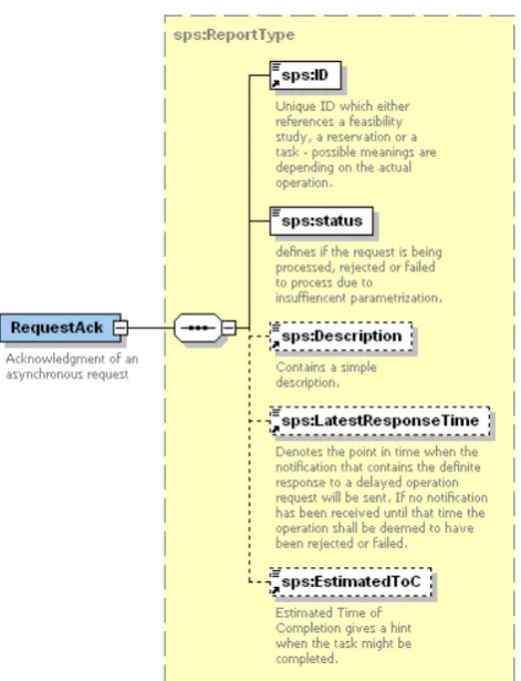
8.3.1. Request acknowledgment schema
The request acknowledgment contains an element of type ReportType:
Figure 8-1 - Request acknowledgment schema
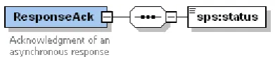
8.3.2. Response acknowledgment status
Response acknowledgment status schema:
Figure 8-2 - Response acknowledgement schema
Table 8-1: Response acknowledgement elements
Name Definition Data type and values Multiplicity
and use
status Indicates that the response
message was successfully received.
String
Possible value are :
- confirmed
- rejected
(in case of the Response message was not successfully received, an exception is thrown)
8.4. Progress reports
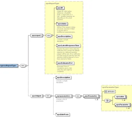
Operations Submit and GetStatus return information about the status of a request. This information is defined as a ProgressReport specified as follows:
The following table describes the elements of the Progress report schema:
Table 8-2: Progress report
Name Definition Data type and values Multiplicity and
use
report see § 8.5 one (mandatory)
Output
Description one (optional)
parameters List of acquired scenes since the date
defined in the DateFrom input parameter.
These parameters are described in the
OutputParameters element of the
DescribeSubmit response.
DateFrom Date from which the result is given. dateTime one (optional)
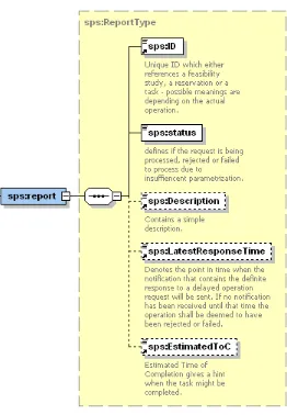
8.5. Report type
The following table describes the elements of the Report type:
Table 8-3: Report type
Name Definition Data type and values Multiplicity and use
ID Identifier for this task,
needed for subsequent update requests.
token one (mandatory)
status Status of the request String enumerates:
“confirmed” “rejected”
“incomplete request” “pending”
“cancelled”
“rejected, alternatives available”
one (mandatory)
Description Text description of the
response
String one (optional)
Latest Response Time
Response will be sent until
LatestResponseTime at latest. In case that no response is received, the
operation shall be
evaluated as
non-feasible.
dateTime one (optional)
estimatedToC Defines estimated time
of completion
9. Information models for EO Programming Requests
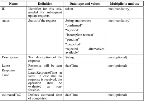
9.1. ParameterDescriptor element
Each sensor may require a different set of tasking parameters. In order to know the list of required parameters, the client performs either a describeGetFeasibility operation, which returns the parameters for a feasibility study, or a describeSubmit, which returns the parameters for sensor tasking.
The tasking parameters are described by the ParameterDescriptor element:
9.1.1. EO profile specific
- The ParameterDescriptor element is based on the SPS InputParameterDescriptor ([NR13]). It has been renamed because it defines not only input but also output parameters.
- the definition element is unbounded. Reason: a parameter may be described by more than one definition. Example: a ROI (Region Of Interest) may be defined by a Polygon OR a Circle.
- the definition element may contain a ParameterDescriptor element (recursivity). Reason: this allows a parameter to contain a list of parameters.
9.1.2. Example
The following example illustrates the recursivity, showing a parameter scene composed by 4
parameters (satellite, resolution, geoLocation and successRate):
<ParameterDescriptor parameterID="scene" updateable="false" use="optional">
<Description>Pseudo scene</Description>
<definition>
<ParameterDescriptor use="optional" parameterID="satellite" updateable="false">
<definition>
<ParameterDescriptor use="optional" parameterID="resolution" updateable="false">
<definition>
<ParameterDescriptor use="required" parameterID="geoLocation" updateable="false">
<definition>
<GeometryDefinition>gml:polygon</GeometryDefinition>
</definition>
9.2. Parameter element
The Parameter Element is used in the GetFeasibility and Submit operations request in order to provide the value(s) for a specific parameter. The encoding follows the description that is part of the definition element of a ParameterDescriptor Element.
9.2.1. EO profile specific
- The Parameter element is based on InputParameter of the SPS standard. It has been renamed because it is used for both input and output parameters.
- because the ParameterDescriptor element has been modified to be recursive, the Parameter Element is modified the same way:
Figure 9-2 - InputParameter element diagram
9.2.2. Example
The following XML fragment shows an example of value definition for a parameter (country) composed by 2 parameters (countryCode and countryName).
<Parameter parameterID="country">
<Parameter parameterID="countryCode">
<value>
<swe:Category>KZ</swe:Category>
</value>
</Parameter>
<Parameter parameterID="countryName">
<value>
<swe:Category>KAZAKHSTAN</swe:Category>
</value>
</Parameter>
9.3. sensorID
The sensorID is an identifier to a set of tasking parameters. A sensorID may represent a sensor (example: SPOT 5), one instrument of one satellite (example: SPOT 5 HRS) or a constellation of satellites (example SPOT+FORMOSAT). The sensorID may also represent a combination of other sensorIDs (an example can be found in § 20.1).
Depending on what the sensor ID represents, the list of input parameters may be different. For instance if a sensorID represents a constellation of satellites (example: SPOT2+SPOT4+SPOT5), one input parameter may be the index of the satellite (example: 5). But in case of the sensorID represents one instrument of one satellite, there will be no need for such input parameter.
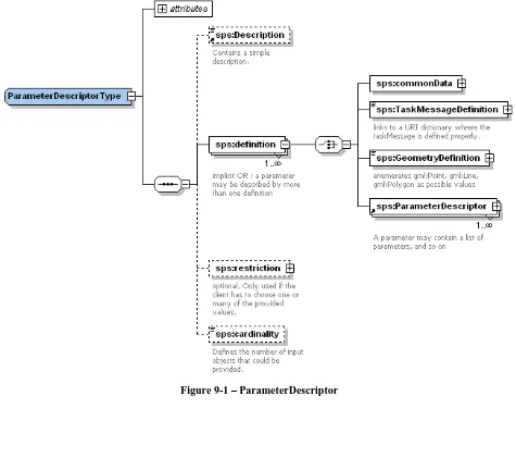
9.4. DeliveryInformationType
This type has been derived by the DeliveryInformationType defined in the Ordering Service ([NR12]).
Tag Name Tag Description
ftp-push FTP URL: address of a user-owned FTP server to which a product can be posted containing also directory, username, password information.
Type: Not empty string (max 255 chars) Syntax :
ftp://„ftpUserName‟:„ftpPassword‟@„ftpAddress‟/„ftpDirectory‟
Example: ftp://muis_intecs:[email protected]/MUIS
ftp-pull FTP URL: address of a provider-owned FTP server from which user can fetch products containing also directory, username, password information. The value is set by the provider, therefore the element has to be set to <blank> in the SubmitRequest
Type: string (max 255 chars) Syntax:
ftp://„ftpUserName‟:„ftpPassword‟@„ftpAddress‟/„ftpDirectory‟
Example: ftp://userOder:[email protected]/XI/EN1
mail Mail element.
Recipient Identification of the receiving person. Type: Not empty string (max 40 chars) companyRef Identification of the receiving entity. postalAddress Postal Address of the user.
streetAddress Street Adress element. Type: String
city City element.
Type: String
state State element.
Type: String postalCode Postal Code element.
Type: String
country Country element.
Type: String
postalBox Postal Box element.
Type: String
telNumber Telephone number of the receiving person.
Type: Not empty string (max 18 chars) matching the following regular expression: “\+?[0-9\(\)-\s]+” (An optional “+” sign followed by a series of (at least one) digit, “(“, “)”, “-“ and blank chars)
e-mail E-mail address of the user.
Type: String
receiverAddress DDS address
Type: String
9.5. Preliminary List of Tasking Parameters
This paragraph proposes the preliminary and extensible list of parameters a client has to provide to task an EO profile asset. The objective is, in a multi mission context, to define the name and the type of the parameters shared by all the EO missions.
Note: through the DescribeGetFeasibility and DescribeSubmit operations, each server has the possibility to:
- mark a parameter as optional or mandatory - restrict the possible values of a parameter - add its own specific parameters
Note : the description of the parameters returned by DescribeGetFeasibility and DescribeSubmit operations is given by using the ParameterDescriptor element (cf. § 9.1). To make is easier to understand, the following description of the parameters uses UML notation and tables.
The parameters are grouped according to their nature:
Figure 9-4 - list of tasking parameters
The following tables describe each group and each parameter in details. The first column contains the name of the group or the element; the second column contains the description; the third
specifies the source document from which the parameter has been derived; the “Mission” column
9.5.1. Priority
Tasking Parameter Name Description Source Mission
QualityOfService Programming Priority All
Urgence Quality Of Service Type: Enumerated string
Possible values are: low, medium, high
[OR4]
Priority Priority level.
Type: Enumerated string
Possible values are : low, medium, high
All
9.5.2. Acquisition parameters
9.5.2.1. SAR mission (radar)
Tasking Parameter Name Description Source Mission
PolarisationMode Polarisation Mode Type: Enumerated String
Possible values: D, Q, S, T, UNDEFINED
Tasking Parameter Name Description Source Mission
PolarisationChannels Polarisation channel transmit/receive configuration: horizontal, vertical.
SCENE: unique attitude acquisition, for tasks specified by time intervals / orbit segments
MONOPASS COVERAGE: coverage acquired through a unique pass; many attitude acquisition necessary
MULTIPASS COVERAGE: coverage may be acquired through several passes
[OR4], [NR11]
SAR, OHR
CoverageRequired Required coverage for the observation Type: Enumerated string
Valid values:
―ANY_COVERAGE‖:acquire any product visible in the area of interest (regionOfInterest parameter) even if overlapping already required sub-areas;
―ANY_REFERENCE_COVERAGE‖: acquire any
product visible in the area of interest (regionOfInterest parameter), but suppress duplicates of the same relative segment (i.e. same relative orbit and passCoverage);
―FULL_COVERAGE‖: within the period (startDate & completionDate) the area (regionOfInterest parameter) has to be fully mapped.
SAR
SwathId Indication of a specific swath achieved by steering In case the sensor viewing characteristics can be changed by steering the instrument the
SwathId identifies the specific Swath used for the single acquisition
Type: String
[NR11] SAR
9.5.2.2. OHR mission (optical)
Tasking Parameter Name Description Source Mission
Resolution Sensor resolution
Type: floating point with allowed values given by the SPS server
[NR11] OHR
AcquisitionMode Type: Enumerated String Possible values are: MULTISPECTRAL PANCHROMATIC BUNDLE
[NR11] OHR
ProgrammingRequestMode Programming type Type: Enumerated String Possible values are:
SCENE: unique attitude acquisition, for tasks specified by time intervals / orbit segments
MONOPASS COVERAGE: coverage acquired through a unique pass; many attitude acquisition necessary
MULTIPASS COVERAGE: coverage may be acquired through several passes
[OR4], [NR11]
SAR, OHR
9.5.3. GeometricCoverageCharacteristics
Tasking Parameter Name Description Source Mission
Mono Mono acquisition [OR4] All
IncidenceAngle cf. § 9.5.6
Stereo Stereo acquisition [OR4] ohr
IncidenceAngle1 cf. § 9.5.6 IncidenceAngle2 cf. § 9.5.6 Constraints
BHMin Minimum base over Height ratio accepted between a stereo pair.
Type: float
BHMax Maximum base over Height ratio accepted between a stereo pair.
Type: float
MaxCoupleDelay Maximum interval of days between two stereo acquisitions. Type: integer
9.5.4. RegionOfInterest
Tasking Parameter Name Description Source Mission
9.5.5. ValidationParameters
Tasking Parameter Name Description Source Mission
cloudCoverPercentage Maximum allowed cloud coverage Type: floating point
Unit: percentage
[OR4] ohr
snowCoverPercentage Maximum allowed snow coverage Type: floating point
Unit: percentage
[OR4] ohr
hazeAccepted Haze presence accepted Type: boolean
ohr
sandWindAccepted Sand wind presence accepted Type: boolean
ohr
9.5.6. SurveyPeriods type
Tasking Parameter Name Description Source Mission
Scene Acquisition of a single scene [OR4] all
SurveyPeriod Start date and end date of acquisition Type: PeriodType (cf § 9.5.7)
all
FrameNumber all
Tasking Parameter Name Description Source Mission
ANX_StartTime Time in millisecond of the acquisition start with respect the ascending node crossing.
ANX_StartTime & ANX_StopTime are alternative to startDate & completionDate.
Type: integer Unit: milliseconds
[NR11] all
ANX_StopTime Time in millisecond of the acquisition end with respect the ascending node crossing
ANX_StartTime & ANX_StopTime are alternative to startDate & completionDate.
Type: integer Unit: milliseconds
[NR11] all
SingleCoverage One (mono date survey) or several (multi date survey) observation periods are requested.
[OR4] all SurveyPeriod Start date and end date of acquisition
Type: PeriodType (cf § 9.5.7)
all SeveralCoverages Only one observation periods is requested, but inside this
period, the area should be covered more than once, eventually respecting a frozen period between two acquisitions.
all
SurveyPeriod Start date and end date of acquisition Type: PeriodType (cf § 9.5.7)
all
Occurrence Number of repetitions of the reference observation period required (including the reference observation as first observation). The reference observation period is defined by startDate & completionDate.
Type: integer
all
FrozzenDays Interval between two consecutive observations. Type: integer
Unit: day Precision: day
all
TemporalSeries
SurveyPeriod Start date and end date of acquisition Type: PeriodType (cf § 9.5.7) Periodicity Acquisition periodicity.