Nzema
East
Tamale
Burkina FAso
T
ogo
Iv
o
r
y C
o
a
st
Accra
Takoradi
Kumasi
Integrated Coastal and Fisheries Governance Initiative
Integrated Coastal
Management Toolkit
coastal resources
This publicat ion is available elect r onically on t he Coast al Resour ces Cent er ’s w ebsit e at ht t p: / / w w w. cr c. ur i. edu.
For m or e in f or m a t ion con t a ct :
Ple a se cit e t h is r e p or t a s:
Coast al Resour ces Cent er ( 2013) . Nzem a East Dist r ict I nt egrat ed Coast al Managem ent Toolk it . I nt egrat ed Coast al and Fisher ies Gover nance I nit iat ive ( Hen Mpoano) Nar raganset t , RI : Coast al Resour ces Cent er at t he Graduat e School of Oceanography, Univer sit y of Rhode I sland 54 pp
D iscla im e r :
This publicat ion is m ade possible by t he gener ous suppor t of t he Am er ican people t hr ough t he Unit ed St at es Agency for I nt er nat ional Developm ent ( USAI D) / Ghana. The cont ent s ar e t he r esponsibilit y of t he aut hor s as par t of t he I nt egrat ed Coast al and Fisher ies Gover nance ( I CFG) I nit iat ive and do not
necessarily relect the views of the United States Government. Associate Cooperative Agreement No.
641- A- 00- 09- 00036- 00 for “ I nt egrat ed Coast al and Fisher ies Gover nance ( I CFG) Pr ogram for t he West er n Region of Ghana,” Under t he Leader w it h Associat es Aw ar d No. EPP- A- 00- 04- 00014- 00.
Cover phot o: For t San Ant onio, Ax im , Nzem a East Dist r ict Phot o cr edit : Lucia Ry bar ova
Coa st a l Re sou r ce s Ce n t e r
Univer sit y of Rhode I sland, Nar raganset t Bay Cam pus 220 Sout h Fer r y Road
Nar raganset t , Rhode I sland 02882 USA
Br ian Craw for d, Dir ect or of I nt er nat ional Pr ogram s Em ail: br ian@cr c. ur i. edu Tel: 401- 874- 6224 Fax : 401- 874- 6920
Fr ie n d s of t h e N a t ion
ht t p: / / w w w. fonghana. or g info@fonghana. or g
P. O Box MC 11
Takoradi, West er n Region, Ghana
H e n M p oa n o
ht t p: / / w w w. henm poano. or g P. O. Box AX 296
Ack now ledgem ent s
Wit h funding fr om t he Unit ed St at es Agency for I nt er nat ional Developm ent ( USAI D) , t he Coast al Resour ces Cent er of t he Graduat e School of Oceanography at t he Univer sit y of Rhode I sland have w or ked t oget her w it h cor e par t ner s
including Friends of the Nation, Worldish and Sustainametrix to implement the
I nt egrat ed Coast al and Fisher ies Gover nance ( I CFG) I nit iat ive, locally k now n as Hen Mpoano. We ar e pleased t o com pile a com pendium of I nt egrat ed Coast al Managem ent ( I CM) infor m at ion and k now ledge generat ed t hr ough t his 4- year I nit iat ive int o a t oolk it t o infor m dist r ict level planning and m anagem ent of
coastal and marine resources. Compilation of this material beneited from the
cont r ibut ions of a lar ge num ber of colleagues and pract it ioner s, including m any m em ber s of t he coast al com m unit ies of t he West er n Region of Ghana and beyond, w ho have assist ed in infor m at ion gat her ing, r esear ch and analy sis. We sincer ely ack now ledge t he cont r ibut ion of t he planning depar t m ent s of t he six coast al dist r ict s of t he West er n r egion in suppor t ing t he developm ent of innovat ive pr ocesses t hat builds I CM int o dist r ict planning pr ocesses and decision m ak ing pr ocedur es. We ar e also grat eful t o t he follow ing indiv iduals for pr ov iding t echnical insight s and guidance dur ing t he pr oduct ion of t his m at er ial: Dr. Chr ist opher Cr ipps ( Spat ial Solut ions) , Dr. Donald Robadue ( Coast al Resour ces Cent er, Univer sit y of Rhode I sland, USA) , St ephen Kank am ( Hen Mpoano) , Pam ela Rubinoff ( Coast al Resour ces Cent er, Univer sit y of Rhode I sland, USA) , Hillar y St evens ( Coast al Resour ces Cent er, Univer sit y of Rhode
Island, USA) and Koi Agbogah (Hen Mpoano). The graphic designs and layouts
as w ell as GI S m apping have been done t hr ough t he har d w or k of Just ice Cam ilus Mensah ( Hen Mpoano) and Lucia Ry bar ova ( Oil Cit y Magazine) .
Finally, w e w ould like t o ack now ledge t he fr uit ful collaborat ion developed
with key oficials and institutions, without which this toolkit will not have
been possible. At t he r egional level t he par t ner ship developed w it h t he
Members, Chief Executives, Directors and Oficers of the District Assemblies,
Regional Coor dinat ing Council, t radit ional aut hor it ies and pr ivat e com panies is appr eciat ed. At t he nat ional level, our collaborat ion w it h t he Nat ional Developm ent Planning Com m ission, Fisher ies Com m ission, Tow n and Count r y Planning Depar t m ent , Minist r y of Env ir onm ent , Science, Technology and I nnovat ion is ack now ledged. I t is our hope t hat t his t oolk it and t he legacy of t he Hen Mpoano I nit iat ive w ill inspir e fur t her w or k in coast al and m ar ine m anagem ent in Ghana.
3
St at em ent fr om Honourable
Jam es A. K. Baidoe, Municipal
Chief Execut ive of t he Nzem a
East Municipal Assem bly
I am grat eful t o t he Coast al Resour ces Cent er for t heir im m ense cont r ibut ion t o t he Municipalit y by w ay of t his w ealt h of r esour ceful docum ent s cont ained in t he t oolk it for Nzem a East . Look ing at t he gr eat effor t t hat has gone int o t he pr oduct ion of t his t oolk it , it obv iously is not business as usual.
I have com e t o lear n m or e about t he Hen Mpoano I nit iat ive and r ealized t hat t her e is m or e t o int egrat ed coast al zone m anagem ent , including
isheries than meets the eye. I have come to respect
t he I nit iat ive’s appr oach, w hich inst ead of im posing ideas, rat her gives const it uent s t he oppor t unit y t o lead pr ocesses and t ake char ge of t heir ow n planning r elat ive t o t he coast al zone.
This Toolkit is a collection of the indings
and ev idence gat her ed dur ing pr ogram m e
im plem ent at ion ( 2009- 2013) as w ell as a sum m ar y of t ools t hat w er e developed at t he t im e for
m anaging t he issues of t he coast al zone and grasping t he oppor t unit ies t hat ex ist . I t t ells us how t o count er t he num er ous challenges w hich ar e being faced, and show s how t he r ich r esour ces of t he coast m ay be m anaged in a sust ainable w ay t o cont inue t o pr ov ide for t he needs of inhabit ant s w hile w elcom ing t he incr edible t echnologies of t he 21st cent ur y w hich have com e t o st ay.
This t oolk it is a useful r esour ce w hich coast al m anager s including dist r ict assem blies and all st akeholder s invest ing in t he coast m ust m ake full use of.
THE CHI EF EXECUTI VE,
NZEMA EAST MUNI CI PAL ASSEMBLY
5
lood and drought), causing r esour ces on sust ainable basis by devolv ing
st orage, subdiv ision of land, or const r uct ion of st r uct ur es, inappr opr iat e developm ent .
Artisanal Fishing leet:
t radit ional canoe- based
ishing vessels. is r esponsible for global w ar m ing) by veget at ion. being ex per ienced, including ex t r em es of w eat her ( st or m s,
Definitions
t our ism . I t s pur pose m ay be t o educat e t he t raveler, t o pr ov ide funds for ecological conser vat ion, t o dir ect ly
beneit the economic
developm ent and polit ical em pow er m ent of local r ecr eat ion and educat ion.
higher as a r esult of t he
inluence of the sea.
Flood : an overlow of rain
w at er or ot her sour ces along
the normal conines of a
r iver, st r eam , drainage w ay
and non- r esident ial buildings and t heir cont ent s. These can include pr ot ect ive w alls and drainage sy st em s t o r edir ect w at er aw ay fr om ex ist ing buildings, r ebuilding st r uct ur es t o m ake t hem const r uct ion t echniques including pier s and elevat ing
the lowest usable loor of a
building above t he level of w at er ex per ienced in event s.
Flood p la in : a level or near ly level land along a
stream or river looded only when the stream low
exceeds t he w at er car r y ing
capacity of the channel. lat or nearly lat land adjacent
t o a st r eam or r iver t hat
ex per iences occasional or
periodic looding.
Gr e e n Be lt : an ar ea w hich has been designat ed ar ound a set t lem ent for no developm ent in or der t o pr ov ide access t o gr een and open spaces and t o encourage m or e dense ur banizat ion. occasionally dur ing seasonal
looding or high seas. social decline in a coast al ar ea.
pr oposed. Ex am ples of w at er dependent uses include:
docks, piers, ish processing
facilit ies, canoe/ boat r epair s, por t act iv it ies r equir ing t he loading and unloading of vessels. Wat er dependent uses exclude housing, hot els, m ot els, r est aurant s, w ar ehouses, m anufact ur ing facilit ies ( except for t hose w hich r eceive and quick ly pr ocess raw m at er ials by ship) et c.
W e t la n d : m eans land w hich is t ransit ional bet w een t er r est r ial and aquat ic sy st em s w her e t he w at er t able is usually at or near t he sur face, or t he land is per iodically cover ed w it h shallow w at er and w hich land in nor m al cir cum st ances suppor t s or w ould suppor t veget at ion t y pically adapt ed t o life in sat urat ed soil. Funct ions w it hin t he nat ural
ecosystem include lood
at t enuat ion and cont r ol, m aint enance of under gr ound and sur face w at er supplies, sedim ent t rapping, er osion cont r ol, pollut ion abat em ent and pr ov ision of habit at s for
INTRODUCTION
Hen Mpoano and Nzema East District Collaboration
This Toolkit is the inal output, for Nzema East District, of the Integrated Coastal and Fisher ies
Governance (ICFG) initiative, which has become locally referred to as HεN MPOANO (Our Coast). It is a
four- year pr oj ect car r ied out by t he Univer sit y of Rhode I sland Coast al Resour ces Cent r e and par t ner s ( see ack now ledgm ent s) , and funded by t he Unit ed St at es Agency for I nt er nat ional Developm ent ( USAI D) .
The Overall Goal of the Hen Mpoano Initiative
Overall Goal: t o suppor t t he Gover nm ent of Ghana in achiev ing it s developm ent obj ect ives of pover t y
reduction, food security, sustainable isheries management and biodiversity conservation.
The init iat ive’s v ision is t hat :
Gh a n a ’s coa st a l a n d m a r in e e cosy st e m s a r e su st a in a b ly m a n a g e d t o p r ov id e
goods and services that generate long term socio-economic beneits to
com m u n it ie s w h ile su st a in in g b iod iv e r sit y .
The purpose of the Integrated Coastal Management Toolkit for Nzema
East District and how to use it
• I t is a cat alogue w hich sum m ar izes t he m ar ine and coast al infor m at ion w hich has been gat her ed by Hen Mpoano. I t is for use by all of t hose w ho ar e act ively involved in car r y ing out I nt egrat ed Coast al Managem ent .
• I t pr ov ides easy- t o- follow link s t o t he sour ce m at er ial, m or e det ailed t echnical infor m at ion.
• I t suggest s “ Pr oj ect s” for incor porat ing I nt egrat ed Coast al Managem ent in t he planning pr ocesses and pract ices of t he Dist r ict Assem bly.
Contents of the Toolkit
Section
ONE: The Coastal Zone and Development Context
TWO:
Integrated Coastal Management
THREE:
Nzema East Municipality Coastal Proile and Development Issues
FOUR:
Integrated Coastal Management Institutions and Processes
FIVE:
Bibliography of Documents and Maps produced by the
Integrated Coastal and Fisheries Governance Programme
SIX:
Best Management Practices
9
9
I
ntr
o
duc
ti
o
n
Ecot our ism Fish landing sit e For t / cast le
Accom odat ion facilit y
Project proposed to be
implemented. Refer to
pages 41-42 for more
information.
Bibliography listed in
section ive.
Examples of Best
Management Practices
in coastal communities
Project
Reference
Case
study
Legend
Sandy beaches Coast al lagoon inlet Rock y shor es N1/ Highw ay Maj or r oad Pr oposed r oads Buffer
Per cept ion of shor eline 30 year s ago Per cept ion of shor eline 60 year s ago Shor eline ex t end w it hin com m unit y Drains
100 year shor eline Gr een belt
Gas pipeline
Dist r ict boundar y Wat er body River
Mangr oves / Wet land 1974 shor eline Nat ural veget at ion
Tidal inluence (yet to be determined)
Coast al Zone Tow n
Com m unit y Resour ces Managem ent Ar eas ( CREMAs)
Coast al zone ( 1000 m buffer ) Bir ds
Cr ocodiles
The Coastal Zone
and Development
Context
Se ct ion
on e :
11
1
s
ec
ti
o
n The Coa
st
al Zo
ne and D
e
ve
l
o
pme
nt Co
nte
x
t
Nzema East ICM Toolkit 2013
Ak ye nim
Bra w ie Am a nfuk um a Solo (U ppe r Ax im )
Ba nk yim Low e r Ax im
Ape w osik a
Ew uk u
Coa st a l Z one
N ze m a Ea st Dist ric t Elle m be lle Dist ric t
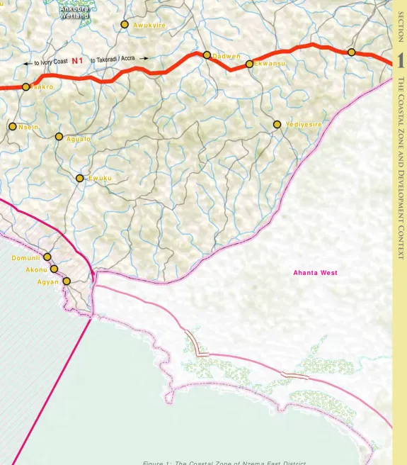
For planning pur poses t he coast al zone of Nzem a East Dist r ict is an ar ea w it h a landw ar d boundar y 1k m fr om t he shor e, or any developm ent in t he land ar ea of coast al sub- basins draining seaw ar d,
or with a signiicant likely impact on coastal and marine resources.
For econom ic pur poses, t he coast al zone also t akes int o account act iv it ies occur r ing out t o 6 naut ical m iles seaw ar d, or t o a dept h of
30m whichever is the greater (coinciding with the ishing grounds of the artisanal ishing leet).
1. What is t he Coast al Zone?
The deinition of the Coastal Zone
A.
Figur e 1:
The Coast al Zone of Ellem belle Dist r ict Source: CRC Ghana
Dom unli
Ew uk u Agua fo N se in
I sa k ro
Da dw e n
Ek w a nsu
Ye diye sire Aw uk yire
Ew uk u
Akonu
Agya n
Ankobra We t la nd
to Takoradi / Accra to Ivory Coast
N 1
Aha nt a We st
Figur e 1: The Coast al Zone of Nzem a East Dist r ict Source: CRC Ghana
13
1
s
ec
ti
o
n The Coa
st
al Zo
ne and D
e
ve
l
o
pme
nt Co
nte
x
t
Tourism Zone Ak ye nim
Bra w ie Am a nfuk um a Solo (U ppe r Ax im )
Ba nk yim Low e r Ax im
Ape w osik a
Dom unli
Ew uk u Agua fo N se in
I sa k ro Ew uk u
Akonu
Agya n
to Takoradi / Accra to Ivory Coast
N 1
Gas Pipeline
N ze m a Ea st Dist ric t Elle m be lle Dist ric t
Coast al feat ur es include beaches, dunes, r iver s, est uar ies, salt m ar shes,
lagoons, wetlands and mangroves as far as they are inluenced tidally (1), so
t he coast al zone in som e cases, ex t ends beyond 1k m fr om t he out er edge of t hese coast al landscapes or ecosy st em feat ur es ( for det ail see Figur e 2) .
The “area of inluence” is the extent of the area inland in which
coastal-r elat ed act iv it ies acoastal-r e t ak ing place ocoastal-r could t ake place, bot h em anat ing fcoastal-r om t he coast , going inland, and im pact ing on t he coast fr om inland ( eg lar ge scale infrast r uct ur e, ur banizat ion, indust r y, pollut ion of r iver s by m ining) . I n Nzem a East t his includes developm ent pr essur es ar ising fr om indust r ial act iv it ies in t he oil and gas sect or s am ong ot her s.
C.
D.
Ew uk u
Da dw e n Avre bo
Anhunya m e
Ek w a nsu
Ye diye sire Aw uk yire
Aha nt a We st
1.2 Area of inluence:
socio- econom ic cont ex t
Nzem a East coast al zone st r et ches bet w een t he Ankobra r iver, t o t he w est t o beyond Agyan in t he east . The Nzem a East coast is r elat ively shor t com par ed t o neighbour ing dist r ict s. I t is not dir ect ly affect ed by indust r ial developm ent , w hich gives it it s m ain advant age. Wit h t he at t ract ive and hist or ic t ow n of Ax im as it s m ain set t lem ent , being at m id- point of t he West er n Region coast al dist r ict s, it has t he pot ent ial t o be t he m ain ser v ice cent er for t he w est er n r egion t our ism and leisur e indust r ies. I t houses t he highest qualit y coast al r esor t s and has a highly at t ract ive coast line.
The N1 j unct ion leading t o Ax im , t he r oad t o Ax im and access r oads t o coast al set t lem ent s ar e a key t o m ak ing t his w or k . Developm ent of an east er n cost al r out e connect ing t o Pr inces Tow n, Cape Thr ee Point s, Ak w idaa and Dixcove/ Busua w ould highly im pr ove t his pot ent ial.
I t is also im por t ant t o not e t hat t he Ankobra est uar y and t he inland w et lands sy st em s ar e par t of t he Gr eat er Am anzule w et lands, t he m aj or feat ur e of t he coast al zone going w est w ar ds.
Figur e 2: Regional and dist r ict m aps showing factors in sphere of inluence
Tamale Burkina FAso
T
ogo
Iv
o
r
y C
o
a
st
Accra Takoradi
Kumasi
15
1
s
ec
ti
o
n The Coa
st
al Zo
ne and D
e
ve
l
o
pme
nt Co
nte
x
t
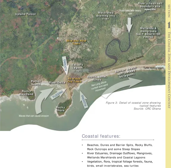
Poc ke t be a c h
Wa t e rshe d dra ining int o
rive r U pla nd Fore st
Rive r De lt a
Roc k y H e a dla nd
Roc k y Shore
Ba r rie r b e a c h/
spit (ba cke d by lagoon
)
Est ua r y La goon (t ida l)
Ak w ida a N e w Tow n
Ak w ida a Old Tow n
FLOODING
FLOODING FLOODING
Waves that can cause erosion
Net Long shore current and sand
movement
Be a c h, be r m , dune s
Rive r – fre sh/sa lt bounda r y sit e
speciic
We t la nds & m a ngrove s SALT BRACK I SH
FRESH
Turtle nesting beach
Road to Dixcove
River rises with heavy rain
Coast al feat ur es:
• Beaches, Dunes and Bar r ier Spit s, Rock y Bluffs, Rock Out cr ops and som e St eep Slopes
• River Estuaries, Drainage Outlows, Mangroves, Wet lands Mar shlands and Coast al Lagoons • Vegetation, lora, tropical foliage forests, fauna,
bir ds, sm all inver t ebrat es, sea t ur t les
Dy nam ics:
Sandy shor elines ar e highly dy nam ic feat ur es t hat evolve in r esponse t o w aves, cur r ent s, t ides and w ind. I n m any cases sandy beaches ar e built up by ocean w ave ener gy and backed by w et lands
or river outlows, and are referred to as barrier
beaches. These sy st em s ar e in const ant m ovem ent in r esponse t o t he ener gy of t he sur r ounding sy st em , and as a r esult ar e not adv isable building sit es.
Figur e 3: Det ail of coast al zone show ing t y pical feat ur es Sour ce: CRC Ghana
17
1
s
ec
ti
o
n The Coa
st
al Zo
ne and D
e
ve
l
o
pme
nt Co
nte
x
t
Integrated Coastal
Management -
why, what and how?
Se ct ion
t w o:
19
2
s
ec
ti
o
n I
ntegra
te
d coa
st
al m
anageme
nt
Nzema East ICM Toolkit 2013
Hen Mpoano, t he I nt egrat ed Coast al and Fisheries Governance init iat ive, beginning in 2009, has w orked w it h all st akeholders advant ages. But t he developm ent opport unit ies need t o respect t he right of com m unit ies, w hich have lived here for cent uries past , t o also cont inue t o enj oy a prosperous and harm onious life. All w ill have t o m eet t he ongoing socio-econom ic challenges exacerbat ed by clim at e change and coast al erosion. Those inland, w it hin t he Dist rict , are also highly dependent on prospect ive invest ors and speculat ors in t he West ern Region Coast al Dist rict s for indust rial and ot her relat ed developm ent . I t has also result ed in pressure on t he coast line for developm ent of resident ial, leisure and hospit alit y. This is coupled w it h t he long est ablished use of large t ract s of land for plant at ion agricult ure, not ably oil palm and rubber. These fact ors have im pact ed adversely on t he space available
for ishing and for subsistence agriculture.
• Fisheries decline: declining ish catches, ( m ost ly at t ribut ed t o increased canoe num bers due t o increasing populat ion) and
unsustainable ishing methods has led to poor ish quality and consequently poor life span of processed ish. Other factors are conlicts between artisanal and semi-industrial ishers/boats and non-existent/
w eak local inst it ut ions for m anaging t he
ishery.
• Coast al Eco- Syst em s t hreat ened:
I ncidence of sand w inning and sea erosion, dest ruct ion of m angroves, w et lands and drainage syst em s.
• Ot her concerns: com m unit y percept ion of inadequat e governm ent represent at ion and at t ent ion; chieft aincy disput es; poor road access/ infrast ruct ure; rising social problem s; general lack of Prim ary and Junior High school educat ion, elect ricit y, pipe- borne wat er, public t oilet s, healt h post s and refuse cont ainers.
R1: Our Coast, Our Future: Western Region of Ghana
This is a m aj or pr oduct of t he Hen Mpoano init iat iv e. I t m ak es t he case t hat a fr esh appr oach t o t he gov er nance of t he coast and isheries will take root only when it addresses issues t hat ar e per ceiv ed by t he people of t he place as im por t ant . I t cov er s t he m aj or coastal and isheries issues and concludes with a discussion of the actions that Hεn Mpoano pr oposed t o t ak e ov er a t hr ee y ear per iod t o is undergoing rapid t ransform at ion due t o act ivit ies of a fast grow ing oil and gas indust ry. A balance m ust be found bet w een developm ent
and the low of coastal ecological goods and services. There is a need to conine oil and
gas- relat ed developm ent t o cert ain “ hot spot s”
(as identiied, for example by the Western
Regional Spat ial Developm ent Fram ew ork) , t o m aint ain sust ainable livelihoods, prot ect t he environm ent and t he areas of high landscape value ( “ green belt areas” ) w hich have been
identiied, while encouraging economic
2.3 What ? The Core
Elem ent s of I nt egrat ed
Coast al Managem ent
The response t o pressures of developm ent
could in fact generate long term beneits
for coast al ecosyst em s and t heir dependent com m unit ies. The est ablishm ent of a Dist rict level com m it t ee t o focus on coast al and m arine issues or t he expansion of t he responsibilit ies of exist ing sub- com m it t ees t o address t hese issues, as has been done at Ahant a West and Sham a, w ould be a great st ep forward for im plem ent ing I nt egrat ed Coast al Managem ent in Nzem a East . Such a com m it t ee w ill provide t he forum for st akeholders involved in such
sectors as isheries, oil and gas, land use
planning and fresh wat er supply t o int egrat e act ions. I t w ill also bring t he concerns of coast al com m unit ies t o t he at t ent ion of t he assem bly for t ranslat ion int o plans and procedures. The Com m it t ee can ident ify and assess issues, suggest and shape policies, priorit ize act ions and evaluat e out com es as t he
to sustaining the ishing industry
• Creat ing Land Use and Environm ent al Policies t hat balance com pet ing int erest s of indust rial, t ourism , food and livelihood securit y, leisure, com m ercial and resident ial act ivit ies w hile prot ect ing t he vit al
ecological funct ioning of t he land and seascape.
• Supporting traditional and inding new livelihoods for coast al com m unit ies t hrough
agriculture, isheries and aquaculture, as
w ell as providing t he access t o fully part ake in t he new form s of developm ent .
• Reducing vulnerabilit y and building adapt ive capacit y of coast al com m unit ies t o t hreat s from hazards and clim at e change including ext rem e w eat her, rising sea levels and coast al erosion.
• Sust ained st akeholder engagem ent
and m oves t o build co- operat ion w it h neighboring dist rict s t hrough a Joint Coast al Developm ent Planning Area; and creat ing effect ive links t o t he regional and nat ional levels of governm ent .
2.4 How ? Syst em s for
im plem ent ing I nt egrat ed
Coast al Managem ent
I nt egrat ed coast al m anagem ent is a part icipat ory process t hat engages com m unit ies, privat e sect or, t radit ional aut horit ies and civil societ y. The m echanism s for im plem ent at ion at t he dist rict level are:
1. The Dist rict ’s Medium Term Developm ent Plan ( MTDP) , and Com m unit y Act ion Plans w hich address set t lem ent grow t h, econom ic developm ent and t he provision of schools, clinics, ot her services, roads and infrast ruct ure.
2. The Dist rict ’s Spat ial Developm ent
Fram ew ork ( SDF) , St ruct ure Plans ( SPs and Local Plans ( LPs) , w hich show w hat can go
where, and resolve potentially conlicting
dem ands on land use in t he coast al zone. 3. St rat egic Environm ent al Assessm ent w hich
ensure t hat t he necessary environm ent al prot ect ion m easures are t aken.
Despit e t he im port ance of dist rict level involving adj oining coast al dist rict s. For t his reason, init iat ives such as t he Dat a Hub w hich has been est ablished at t he West ern Regional Coordinat ing Council by Hen Mpoano
for technical support, the ledgling Joint
This j oint approach t o planning and decision-m aking can involve:
• Adopt ion of region- w ide policies for
preventing and mitigating lood hazards.
• I nform at ion sharing on t echniques for assessing hazards and adapt ive capacit y of coast al places ( eg t hose used in vulnerabilit y assessm ent and adapt ive planning exercises at Dixcove and Akw idaa) .
• Collaborat ion bet w een agencies at regional and nat ional levels on coast al issues. • Effective mechanisms for conlict resolution
and dialogue w it h part ies affect ed by developm ent decisions.
• Joint init iat ives on prot ect ion/ rest orat ion of crit ical habit at s, forest s and w et lands of
regional signiicance by programs such as
Com m unit y Resource Managem ent Areas ( CREMAs) .
• Decision m aking on large facilit y sit ing and m anagem ent of alt erat ions of t he coast al zone.
All of t hese w ill becom e m ore evident in t he com ing years if det ailed planning and decision- m aking can be done at com m unit y level and linked t o regional and sub- regional co- ordinat ion of nat ional and int ernat ional invest m ent s.
P1: Form Working Groups to deal with
speciic coastal issues, for example
the Amanzule Working Group
Project
2.5 Opport unit ies t o
I m plem ent I nt egrat ed
Coast al Managem ent
Se ct ion
t h r e e :
NZEMA EAST DISTRICT
COASTAL PROFILE AND
DEVELOPMENT ISSUES
23
Nzema East ICM Toolkit 2013
3
s
ec
ti
o
n NZEM
A EA
ST D
ISTRI
C
T COA
ST
AL PR
O
FILE AND D
E
VEL
O
PMENT ISSUES
Sandy beaches
R2: Adaptive Capacity for Resilient Coastal
Communities: Climate Change and Natural
Hazards Issues in Coastal Districts of
Ghana’s Western Region
I n 2011 and 2012, Hen Mpoano assessed 77 West ern Region coast al com m unit ies in t he Dist rict s of Jom oro, Ellem belle, Nzem a East and Ahant a West t o gain an underst anding of t heir concerns and capacit y. The
indings indicated that adaptive capacity is limited in
coast al com m unit ies. Som e locat ions are faring bet t er t han ot hers, but overall, coast al com m unit ies have w eak abilit y t o respond t o em ergencies generat ed by nat ural hazards, t hey suffer social and econom ic developm ent challenges t hat are w orsening, and t hey have a relat ively low abilit y t o m anage coast al resources in a way t hat w ill ensure sust ained product ivit y and
beaches are gently sloped to generally lat and
pat ched w it h sandy m ounds and boulder s. The coast line is dot t ed w it h hospit alit y facilit ies, dense
human (ishing) settlements with ish landing and
pr ocessing ar eas, and par t of t he r iver Ankobra
estuary and its ecologically signiicant wetlands that are habitats for diverse lora and fauna. In
t he uplands t her e ar e pat ches of for est and r ich highest landscape value and nat ural beaut y. The r ock y capes have for m ed bay s, t he best of w hich
beaches and rocky outcrops, estuaries, ishing
v illages, and hist or ic for t s com bine t o give t his sect ion of coast it s unique qualit ies.
3. 2 Charact er ist ics of Coast al
Zone: off- shor e m ar ine ar eas
and isheries
The off- shor e ar eas of t he coast al zone ar e
actively used by the artisanal (traditional) ishing leets. Fishing is also the province of larger, Ghana-based semi-industrial ishing vessels and
indust r ial, int er cont inent al vessels. Ther e ar e
locally breeding ish, those inhabiting the Guinean
cur r ent acr oss West Afr ica and t hose t hat m igrat e acr oss lar ger dist ances ( such as blue w hales) . Sur vey s have been car r ied out t o det er m ine t he locat ion and t y pe of m ar ine life including j uvenile
ish and their breeding, and Marine Protected Areas are being proposed to protect isheries and
Mar ine ar eas ex per ience m any ot her uses such as for a local, nat ional and int er nat ional highw ay, for leisur e, cables, pipelines, oil and gas ex ploit at ion. The Mar ine ar eas ar e subj ect t o incr easing k inds of pollut ion fr om t he w ast es of m ar ine and non- m ar ine act iv it ies ( dum ping of w ast e) . As capacit y for coast al m anagem ent incr eases, spat ial planning for t he seascape w ill be necessar y t o ensur e har m ony bet w een t radit ional uses of
the sea for ishing and oil and gas production
act iv it ies. Mar ine Spat ial Plans ar e now being used t hr oughout t he w or ld t o cope w it h t he incr easing pr essur es.
25
Nzema East ICM Toolkit 2013
3
s
ec
ti
o
n NZEM
A EA
ST D
ISTRI
C
T COA
ST
AL PR
O
FILE AND D
E
VEL
O
PMENT ISSUES
P2: Prepare Marine Spatial Plan
P3: Continue with research on Algae
Bloom leading to proposals for its
management.
R3: Nearshore Rocky Reefs of Western
Ghana, West Africa: Baseline ecological
research surveys.
Ecological infor m at ion on t he near
Project
Reference
shor e r ock y r eef habit at s ( NSRH) of Ghana is ver y
limited. The present study ills this knowledge gap,
by invest igat ing t he general st at us of t he NSRH and
isheries of western Ghana, and providing baseline information on the ish, invertebrate and benthic
com m unit ies.
R4: Assessment of Fishing Grounds in the Nzema East and
the Ahanta West Districts
A rapid appraisal conduct ed in nine ( 9) m ain landing sit es in t he Nzem a East and Ahant a West dist r ict s bet w een 14t h and 21st Sept em ber 2010. The com m unit ies v isit ed w er e, Ankobra ( Sanw om a) , Apew osik a ( subur b of Ax im ) , Miam ia, Pr incess Ak at ak y i, Cape Thr ee Point s, Ak w idaa, Dixcove, Busua and But r e. The pur pose of t his assessm ent w as t o ascer t ain pr im ar y infor m at ion
of the spawning and ishing grounds among others.
The r esear ch t eam w as m ade up of t w o per sons; a st aff of t he West er n Regional branch of t he Ghana Canoe Fisher m en Associat ion and a st aff of t he Fr iends of t he Nat ion. Dat a w as collect ed t hr ough focus gr oup discussions, par t icipat or y m apping, dir ect obser vat ions and key infor m ant s int er v iew s.
R5: Determining The Origin And Ecology Of A Macroalgae
(Ulva clathrata) Bloom Along The Coast Of Western Ghana
And Cote d’Ivoire.
Figur e 5:
Sensit iv e ar eas in need of pr ot ect ion in Ellem belle Dist r ict .
M a rine protected are a s We t la nds
Ak ye nim
Bra w ie
Solo (U ppe r Ax im ) Ba nk yim Low e r Ax im
Ape w osik a
Dom unli Akonu
Agya n
N 1
Aha nt a We st
Elle m be
lle D istric t
Ew uk u Agua fo N se in
I sa k ro
Da dw e n Avre bo
Anhunya m e
Ek w a nsu
Ye diye sire Aw uk yire
Apa Ta m
Figur e 5:
Sensit iv e ar eas in need of pr ot ect ion in
Nzem a East Dist r ict . M arine
protec t ed a re as
3. 3 Charact er ist ics of t he
Coast al Zone: ar eas of
r est orat ion and pr eser vat ion
Wet lands, m angr oves, lagoons, r iver s and est uar ies, pr ov ide essent ial ecosy st em ser v ices and ar e also cr it ical for m aint aining a healt hy
ishery (see section 3.4.2 below). In Nzema
East , m ost of t hese r esour ces ar e found inland for m ing a net w or k of nat ural ar eas j oined t o t he Ankobra Est uar y, w hich ar e a pr ior it y for conser vat ion, but w hich ar e not par t of t he coast al zone it self. Her e, it is t he coast al veget at ion on higher gr ound w hich r equir es at t ent ion.
P4: Undertake public education on the
beneits of conservation of coastal
ecosystems.
P5: Work with Marine Protected Areas
Inter ministerial Committee over
designation of marine protected
areas.
Project
Ult im at ely, conser vat ion of t hese r esour ces could be ex t ended t o include near shor e ar eas t o for m a net w or k of m ar ine pr ot ect ed ar eas.
3. 4. Relief, Drainage and
Clim at e: Coast al Dy nam ics,
Hum an Uses and I m plicat ions
3. 4. 1 Shor eline Beaches, Dunes and
Bar r ier Spit s: hum an and nat ural
hazar ds
Due t o r ising sea level in r ecent decades, m ost bar r ier beaches in Ghana ar e r et r eat ing at a rat e of about 1m per year and in t he West er n r egion, ar e est im at ed t o be r et r eat ing at 2m per year on t he average ( 2) . Er osion, sea level r ise, and sand w inning fr om t he beach can all r esult in land loss and t he inland m ovem ent of t he shor eline. Sect ions of t he shor eline in t he dist r ict ar e not ed t o have er oded considerably over t he past 6 decades, causing t he disappearance of
Ankobra We t la nd
P6: Increase collaboration with the Ministry
of Water Resources, Works and Housing for
regulating private development and installing
publicly funded defenses.
P7: Where acceptance of land loss is agreed as the
best option long term, plan re-settlement schemes and
incorporate as objective in Structure Plans.
P8: Develop a public education programme on coastal
hazards and climate change
P9: End destructive sand winning practices by use of bye
laws and community sensitisation
P10: Prepare coherent shoreline management plans to
regulate coastal land use.
R6: Report on Characterization of coastal
communities and shoreline environments in
the Western Region of Ghana.
This r epor t pr ov ides infor m at ion on t he condit ions and env ir onm ent al, social and econom ic issues faced by 89 coast al com m unit ies in t he six coast al dist r ict s of Ghana’s West er n Region. Rapid appraisals of coast al com m unit ies, dist r ict level validat ion w or k shops and secondar y lit erat ur e r ev iew w er e under t aken t o pr ov ide addit ional infor m at ion t hat w ill ult im at ely
cont r ibut e t o assem bling t he baseline. While rapid appraisals gleaned com m unit y scale infor m at ion, it also pr ov ided t he oppor t unit y t o socialize t he init iat ive am ong coast al com m unit ies v isit ed. The pur pose of dist r ict scale w or k shops w as t o solicit input s fr om local people as w ell as r eact ions t o
indings of the rapid appraisals and to incorporate
local per cept ions of changes int o a dist r ict level
synthesis of coastal and isheries governance
issues.
beach has been er oded w it hin t his t im efram e, especially in m ost t hr eat ened com m unit ies such as Agyan, Akonu, Dom unli, Ak yenim and Am anfuk um a. This phenom enon st ill cont inues due t o high sea w ave ener gy and sea level r ise,
Support Urbanization, Sanitation and Wastewater
Management in the Coastal Zone:
Dixcove Case Study
of gabions and boulder s and ot her engineer ing solut ions. How ever, high ener gy w aves, st r ong cur r ent s and per iodic st or m s ex pose t he w eak ness of t hese defense m echanism s. I n m any cases r elocat ion is t he only r ealalternative, but accepting this is dificult,
3. 4. 2 River est uar ies, Drainage
Outlows, Mangroves, Wetlands,
Mar shlands and Coast al Lagoons
As st at ed above, t hese ar e not r eally pr esent in t he coast al zone it self, but ar e pr om inent off t he Ankobra fur t her inland on t he w est er n boundar y of t he Dist r ict . Wet lands and coast al w at er r esour ces ser ve v it al funct ions in t he env ir onm ent . They pr ov ide habit at for m any plant s and anim als,
including migratory birds and many types of ish.
Mangr ove ar eas, in par t icular, ar e im por t ant t o
the overall health of the marine isheries, because they provide habitats for shellish as well as nursery grounds to juvenile ish. Mangrove wood
is har vest ed for a var iet y of pur poses, but t his pract ice should be lim it ed due t o t he dam age t o w et lands t hat over har vest ing causes.
Good Management Practices
Reduce Impacts from Flooding and Erosion:
Akwidaa Case Study
Case
study
Fr om a hy dr ologic per spect ive, w et lands ser ve t o dam pen t he effect s of changing w at er levels,
thereby providing protection from looding. In the process of slowing loodwaters, wetlands trap and
st or e sedim ent s, lim it ing er osion and in som e cases act ually building up soil. Thr ough t his pr ocess, t hey pr ot ect coast al w at er s fr om excessive r unoff and sedim ent at ion. Coast al com m unit ies oft en r ely on t hese ar eas for t heir dr ink ing supply, so m aint aining
the low levels and cleanliness of the water is vital
R7: Rapid assessment of mangrove status and
conditions for use to assess potential for marine
payment for ecosystem services in Amanzule and
surrounding areas in the western coastal region of
Ghana, West Africa
Ghana’s m angr ove ecosy st em s ar e t r em endously valuable, pr ov iding ecosy st em ser v ices like car bon
sequestration, protection from storms, loods, and
er osion, pr ov ision of t im ber and non- t im ber for est pr oduct s, pr ocessing of w ast e and nut r ient pollut ion, aquacult ur e and agr icult ur e suppor t , and habit at for aquat ic and t er r est r ial species. Yet , as in m any ot her par t s of t he w or ld, shor t - t er m developm ent needs ar e under m ining long- t er m m angr ove healt h and sur v ival. For t unat ely, econom ic m echanism s have t he pot ent ial t o t ip t he balance t ow ar d r est orat ion, m aint enance, and pr ot ect ion of m angr ove for est s. The need for pr oper valuat ion of m angr ove ecosy st em ser v ices under pins such m echanism s t ow ar ds t he est ablishm ent of any r ealist ic pay m ent for ecosy st em ser v ices schem e in any given m angr ove or w et land habit at .
R8: Coastal Hazards and Flooding Risk in Ghana’s Western Region
This issue br ief highlight s t he key issues facing Ghana’s
Western Region in terms of coastal looding in low-lying
ar eas as w ell as shor eline er osion, and r ecom m ends policy opt ions t o im pr ove public safet y and r educe env ir onm ent al im pact s.
R11: Biodiversity Threats Assessment for the Western Region of
Ghana.
This r ev iew of biodiver sit y t hr eat s in t he coast al zone of
t he West er n Region of Ghana cover s bot h t er r est r ial and m ar ine sy st em s and includes m aps and descr ipt ions of im por t ant w et lands and habit at s.
R12: Rapid Biodiversity Assessment on the Essei and Butuah
Lagoons and the Whin River Estuary in the Sekondi-Takoradi
metropolis of the Western Region of Ghana
This rapid Biodiver sit y Assessm ent on t he Essei and But uah Lagoons and t he Whin River Est uar y in t he
Sekondi-Takoradi m et r opolis of t he West er n Region of Ghana concludes t hat deplorable m anagem ent , ignorance or
conlict of interest on the part of users has led the wetlands
ont o a pat h of pot ent ially ir r ever sible dest r uct ion. A new t y pe of coast al m anagem ent t hink ing and pract ice ar e needed t hat t akes int o account Ghanaian econom ic, socio-cult ural and env ir onm ent al per spect ives.
R13: Approved byelaws for wetland conservation in 4 areas (Butre,
Busua, Akwidaa, and Princes town)
Cape Thr ee Point s – Pr inces’ Tow n CREMA Const it ut ion and Resour ce Managem ent Bye- law w as am ended t o include pr ov isions t hat call for t he developm ent of m anagem ent plans for CREMA w et lands. The r ev ised bye- law w as appr oved by t he Assem bly.
R14: Model Bye-laws for Coastal Management in Ghana:
Experiences from Shama District
Thr ough Hen Mpoano- facilit at ed t echnical assessm ent s, st akeholder engagem ent s and par t icipat or y m apping
exercises, model bye-laws and policy statements for lood
hazar d m it igat ion, shor eline and w et land m anagem ent w er e for m ulat ed and appr oved by t he dist r ict assem bly.
29
Nzema East ICM Toolkit 2013
3
s
ec
ti
o
n NZEM
A EA
ST D
ISTRI
C
T COA
ST
AL PR
O
FILE AND D
E
VEL
O
Highest
Above average
Average
Below average
Low est
Wat er
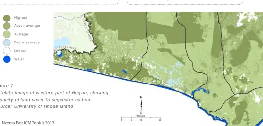
Figur e 7:
Sat ellit e im age of w est er n par t of Region, show ing capacit y of land cov er t o sequest er car bon.
3. 5 Veget at ion, Flora, Tr opical
Foliage For est s, Wildlife
3. 5. 1 Coast al Veget at ion, far m ing, for est
r eser ves.
The cur r ent m aj or it y land use in Nzem a East Dist r ict is by subsist ence far m s, t r ees and for est , m ining, coconut and palm oil plant at ions. Car bon sequest rat ion capacit ies in Figur e 7 illust rat e t he ex t ent of differ ent t y pes of use because t hey br oadly equat e w it h ur ban ar eas, far m cr op ar eas, t r ee cover including oil palm , r ubber and for est .
The m apping of r ural land uses and slope analy sis w ill enable decisions t o be m ade about t he m ost
eficient balance of uses. The designation of land for
agr icult ur e, added t o pr ot ect ed ar eas/ cor r idor s for w ildlife w ill enable t he best decisions t o be t aken about ar eas for ur banizat ion, t our ism , leisur e and indust r ial developm ent .
I n t his cont ex t , it has been pr oposed ( 2) t hat , consider ing t hat even lar ge ar eas of gr een r esour ces m ay be per m anent ly dest r oyed t hr ough unplanned developm ent , t he concept of a “ Gr een Net w or k ” w ill be a useful developm ent planning t ool for t he Dist r ict .
R16: Land Cover Mapping of the Greater Cape
Three Points Area Using Landsat Remote
Sensing Data Map Book
This is t he com panion book of m aps for t he land cover st udy. The land use and land cover
map products created in this study are the irst
available dat a for t he coast al r egion of Ghana. The m aps r epr esent an im por t ant st ep in t he m anagem ent of it s nat ural r esour ces. Land use and land cover m aps allow land m anager s, policy and decision m aker s, and local com m unit ies t o m ake infor m ed decisions about t he fut ur e of t heir nat ural, cult ural and econom ic r esour ces. This set of m aps can also pr ov ide a w indow int o how t he landscape has changed as t he baseline dat a for possible fut ur e w or k . Wit h t he baseline dat a r eady, t he nex t st ep of change analy sis w ill be possible. The choice t o
use the U.N. Land Cover Classiication System also provided the lexibility to meet classiication needs
in t he fut ur e w hile st ill m aint aining cont inuit y w it h past w or k .
R17: Report from Community Conservation on Primates in
the Western Region.
Field not es fr om Hor w ich’s sit e v isit and
r ecom m endat ions for im pr oved m anagem ent of t he for est r eser ves and alt er nat ive livelihoods for t he adj acent com m unit ies. Hor w ich m ade t w o addit ional v isit s in 2012 w hich ar e also included in t his r epor t .
R18: Land Cover Mapping of the Greater Cape Three Points
Area Using Landsat Remote Sensing Data
The land use and land cover m ap pr oduct s cr eat ed
in this study are the irst available data for the
coast al r egion of Ghana. The m aps r epr esent an im por t ant st ep in t he m anagem ent of it s nat ural r esour ces. Land use and land cover m aps allow land m anager s, policy and decision m aker s, and local com m unit ies t o m ake infor m ed decisions about t he fut ur e of t heir nat ural, cult ural and econom ic r esour ces. This set of m aps can also pr ov ide a w indow int o how t he landscape has changed as t he baseline dat a for possible fut ur e w or k .
P14: Map and plan rural land uses areas. Develop
strategy for balance of agricultural land uses and set
buffers for food crop production as well as conserve
ecosystem functions and services.
3. 6 Set t lem ent s, Spat ial
Analy sis, and Sit ing of
I nfrast r uct ur e,
3. 6. 1 Gr ow t h of t he Coast al and
Fishing Set t lem ent s
The populat ion of coast al set t lem ent s cont inues t o incr ease st r ongly t hr ough nat ural gr ow t h fr om uncont r olled bir t hs, t eenage pr egnancy and
high in-migration of isher folks (4). The coastal communities experience an inlux of itinerant boats and ishermen, particularly during the high ishing
seasons bet w een July and Sept em ber. new indust r ial developm ent .
3. 6. 2 Cult ural cont ex t and t radit ions
in Coast al Com m unit ies
Artisanal ishing communities represent a
unique and dist inct cult ur e w hich ar ises fr om t he act iv it y. Fisher m en ar e at sea in canoes for t hr ee t o four day s at a st r et ch, w hile ot her s ar e
mending and making boats, nets and ishing gear. Women prepare, smoke and sell the ish. These
com m unit ies ar e pr edom inant ly of t he Nzem a et hnic gr oup.
The Nzem a East Municipal Ar ea has t hr ee
param ount cies under t he Nzem a Manle Tradit ional Council w it h it s headquar t er s at Esiam a in t he
Subsequent ly t he colonial aut hor it ies negot iat ed t r eat ies under Rom ano- Br it ish law w hich
led t o indiv idual land t it les and leases being grant ed, and subst ant ial land being t aken int o gover nm ent ow ner ship. Wher e m ost land is not
registered, there are frequent conlicts over
it s ow ner ship. Fam ilies w ho have subsist ed on coast al m anagem ent w ill becom e easier.
3. 6. 4 Spat ial Analy sis: Coast al
P33: Support local festivals and educate/
promote retention of cultural identity of
coastal and ishing communities.
Project
R19: ‘Faith In Action’ Faith Based Action
For Creation Care In Coastal Communities
Of Western Region.
organisers beneitted immensely from the
exchanges and ex per iences shar ed. The m ain
recommendations for keeping the ire burning
is ensur ing t hat t he eco- net w or k s w hich have been est ablished live beyond t he lifespan of t he init iat ive t o per for m t he funct ions of m obilising r eligious or ganisat ions and advocat ing for r esponsible coast al r esour ce use.
Set t lem ent s
I t is essent ial t hat wat er dependent and wat er enhanced uses w it h result ing value ret urns are used t o m axim ize value in areas of t he coast al zone and t hat t heir sit ing prevent s erosion and furt her dam age t o t he coast . To achieve t his it w ill be necessary t hat t he ground rules for shoreline developm ent are included in t he St ruct ure Plan, Local Plans and t hrough Assem bly Bye- Law s.
3.6.6 Social issues, wat er, wast e,
and sanit at ion
Coast al com m unit ies are experiencing a severe decline in t heir t radit ional livelihoods t hrough bot h nat ural and m an- m ade causes. Povert y levels are increasing, educat ional levels are declining rat her t han im proving, populat ion cont inues t o rise t hrough high birt h rat es including t eenage pregnancies and declining
Set t lem ent s in Nzem a East
historic fort and buildings, ishing community and
cent r e for high end leisur e facilit ies near by. I n or der for t his t o happen in a w ay w hich cr eat es an or der ly, m oder n t ow n in w hich t he ex ist ing
community and incomers both beneit from a
high qualit y env ir onm ent , invest m ent in social am enit ies, w at er, pow er, connect ing r oads, w at er cour ses needs t o be m ade for t he lar ger ur ban ar ea w hich includes t he ex ist ing ar ea. This should
easily be able to be inanced by new investors
if t he planning and per m it t ing pr ocess aim s for high qualit y, high values and negot iat es shar ing of im pr oved land values. A st r uct ur e plan for t he
P16: Prepare Structure Plans and Local
Plans for Axim Conurbation including up
to N1 junction.
P17: Prepare Community Action Plans
to address vulnerability and improve
resilience for all coastal communities
P18: Apply good coastal management
practice in major leisure developments
Project
R20: Dixcove Plan
Hen Mpaono w or ked w it h com m unit y m em ber s and dist r ict assem bly
oficers Community Action Plan for
adapt at ion and im pr oved r esilience at Dixcove, w hich has ex per ienced , m aj or er osion and
looding problems. The plan included a draft outline Structure Plan which identiied main
The improvement of water supply, collection and inal t he wat er resources planning for t he region indicat es t he likelihood of a grow ing crisis gap bet w een supply and dem and. This is m ade w orse by t he pollut ion from m ining of t he region’s m aj or rivers and wat er courses, a part icular concern in t his Dist rict w here t here is ext ensive m ining act ivit y on t he Ankobra River.
Shoreline sanit at ion, especially at t he densely
populated ishing communities, requires more
at t ent ion due t o t he im plicat ions on hygienic
handling and processing of ish. It is common to ind
disposed fecal m at t er washed ashore direct ly t o t he
ish landing sites and the beaches, contaminating the ish that is harvested. Efforts made by Zoomlion and Zoil have produced no signiicant change in the
sanit at ion condit ion. I m proving sanit ary services in t he coast al com m unit ies is necessary for t he follow ing reasons:
Good Management Practices
to Support Manage Large-Scale Leisure
Development to Beneit the Community,
the Private Investor and the Ecosystem:
Princes Town Case Study
Case
study
1. I ncrease t ourist visit at ion t o t he coast lines. 2. Elim inat e t he causat ive agent s of t hose
wat er and excret a- relat ed diseases 3. Convert wast e int o readily re- usable
resources and so conserve bot h wat er and nut rient s.
4. Prevent t he pollut ion of any body of wat er ( ground or surface wat er) t o w hich
the efluent escapes or into which it is
discharged.
5. To reduce organic pollut ion of wat er for drinking and ot her dom est ic purposes. 6. Safeguard aquat ic life and m aint ain a
healt hy ecology of surrounding com m unit ies.
P19: Map critical watersheds shared
by adjoining districts and subject to
collaborative management
P20: Continue and extend coastal and
shoreline waste management schemes
P21: Reinstatement of wells and
boreholes to be conditions of new
developments and take account of
salination threats
Project
R22: Opportunities for integrating family
planning, health and nutrition interventions into
coastal-isheries governance agendas in Western
Region, Ghana
Oppor t unit ies for int egrat ing fam ily planning, healt h
and nutrition interventions into coastal-isheries governance agendas are identiied for the coastal
dist r ict s of Ghana’s West er n Region.
R23: Facilitating Integrated Population Health and Environment
in Five Communities in the Shama District and Two
Communities in the Ahanta West District: Achievements and
Lessons Learned
R24: Freshwater supply and distribution: a developing crisis in
the Western Region
This issue br ief highlight s t he key issues facing Ghana’s West er n Region in t er m s of fr esh w at er supply and dist r ibut ion and r ecom m ends policy opt ions t o pr ot ect w at er r esour ces and insur e equit y in t heir use and dist r ibut ion.
R25: Improving Livelihoods through Plastic Waste Management
in Coastal Communities of the Western Region of Ghana:
Achievements and Lessons Learned
3.7 Econom y and
Livelihoods
3.7.1 Overview
I t is est im at ed t hat over 65% of t he
econom ically act ive populat ion are engaged
in agriculture (including ishing) and agro-
processing. Before 1965, t he m aj or cash crops grow n in t he area w ere coconut and cocoa w it h cassava and plant ain being t he m aj or food crops. I n 1965, t he Cape St . Paul’s Wilt Disease dest royed alm ost half of t he coconut plant at ions along t he sout h- east ern coast line. This affect ed t he econom ic livelihood of people in t hese areas leading t o low incom e and increased unem ploym ent . This has been a m aj or fact or t hat shift ed t he at t ent ion of coconut farm ers t o rubber plant at ion.
How ever, m ining indust ry and associat ed services, incom ing resident ial, t ourism , leisure and services developm ent s w ill increasingly be t he basis of t he econom y and em ploym ent .
Coastal communities can beneit from the new economic opportunities through improving ish
and agricult ural value chains and developm ent of associat ed sm all and m edium scale
ent erprises t hat at t ract yout h int o agricult ure. Hum an Resource capacit y developm ent relat ed t o t he new form s of em ploym ent hospit alit y services is t he kind of forward looking proposal w hich should be st rongly support ed.
Declining com m unit y livelihoods over t he years, cont ribut ing t o slow econom ic grow t h and rising povert y, is a m aj or issue in t he Nzem a East Dist rict . The yout h are show ing int erest in illegal sm all scale gold m ining, sand w inning, st one quarry and charcoal product ion w hich w ill deepen t he decline in farm ing livelihoods. There is also out m igrat ion of t he yout h for m enial j obs in bigger t ow ns like Takoradi, Sekondi, Tarkwa and ot hers, w hich w eakens com m unit ies over t he long t erm .
R26: Livelihoods and poverty reduction in coastal
communities in the Western Region of Ghana:
analysis of livelihoods baseline data of the ICFG
program
incom e levels and sour ces, seasonalit y issues, asset s, v ulnerabilit y )2. Establishing a simpliied nutritional baseline of
households in target communities and ish species
consum ed
3. I dent ify ing oppor t unit ies for livelihood
diversiication in the target opportunities
Income diversiication is a means to cope with risks and seasonality related to agriculture and isheries.
Pover t y is m ult i- dim ensional as it not only r elat es t o
capital, inancial and natural assets and access to
social net w or k s. The livelihoods sur vey conduct ed by t he Hen Mpoano pr oj ect aim ed t o encom pass all t hese dim ensions.
R27: Livelihood Diversiication and ishing communities in
Ghana’s Western Region
Livelihood diversiication in the ishing communities
in Ghana’s West er n Region r equir es a focused effor t t o develop oil or t our ism in a w ay t hat cr eat es local
employment and encourage people to exit ishing,
leav ing a less- cr ow ded sect or, m or e am enable t o gradual change, w it h a m or e educat ed younger generat ion shift ing int o ot her sect or s and places.
P23: Create links between local communities,
tertiary/ vocational education and incoming
developments in oil and gas, supply industries,
tourism and hospitality, new residential
developments, and construction.
Ak ye nim
Fishing and farm ing livelihoods are int erlinked. I n t he farm ing season ( raining seasons) incom e from
ishing is used to purchase farming inputs whilst investments shift back to ishing during the ishing
seasons. Farm ing consist s of subsist ence, cash crops and plant at ions. Oil Palm is a m aj or cash crop in t he coast al areas. Coconut was one of t he m ain cash crops unt il t he Cape Saint Paul Wilt disease gradually dest royed m ost of t hem from t he 1965 onwards.
3.7.3 Fishing
Active ishing activities occur in about 10 ish landing
sit es dot t ing t he coast of Nzem a East dist rict . Fish landings have declined over t he last 15- 20 years,
mostly attributed to increasing use of illegal ishing practices such as light ishing, use of monoilament nets, dynamite, carbide, pair trawling and ishing
w it h obnoxious subst ances. I llegal pract ices result in
poor ish quality, with ishmongers and processors
in part icular expressing great er w orry about t he
short shelf-life of processed ish. Added to this is
t he arrival of algae bloom w hich adversely affect s
artisanal marine ishing, and damage to breeding grounds by inilling and pollution. The dramatic decline in isheries can be reversed through
P14: Map and plan rural land
uses areas. Develop strategy
for balance of agricultural
land uses and set buffers for
food crop production as well as
conserve ecosystem functions
and services.
P25: Create land banks or
reserves for agriculture for
local food production
Project
signiicant reductions in ishing effort, best
decided by co- m anagem ent inst it ut ions including com m unit y- based. Managem ent of pelagic,
demersal and those small scale ish stocks found
in est uaries, lagoons, rivers, lakes and nearshore m arine areas w ill require different co- m anagem ent approaches w it h expressions at t he nat ional, regional and com m unit y scales respect ively.
R31: Marine Police Training Workshop Proceedings. Fresh
Approaches for promoting compliance and enforcement.
The Hen Mpoano I nit iat ive discussed w it h t he Fisher ies Com m ission and t he Ghana Police Ser v ice ( GPS) w ay s t o suppor t aspect s of t he t raining of
the newly assembled oficers of the MPU on the ecological justiications of the Fisheries Laws. Approval
w as sought fr om USAI D t o or ganize shor t t raining m odules for t he unit . A cur r iculum for t he t raining w as appr oved by t he GPS, FC and USAI D w hich paved t he w ay for t he t raining w or k shop. I t consist ed of ser ies of lect ur es, gr oup assignm ent s, pr esent at ions
and discussions, role plays, and ield visits to ish landing sites and ishing communities. The visits were important for the Police Oficers as that inducted them
int o t he com m unit ies.
R32: Joining Forces to Collaboratively Manage Ghana’s
Fisheries Resources: the role of a Fisheries Working Group
In order to sustain the socio-economic beneits from
coast al r esour ces and biodiver sit y, t her e w as t he need for a collaborat ive appr oach t o m anagem ent rat her t han leav ing t he Fisher ies Com m ission t o
single-handedly manage the isheries and coastal resources.
A Fisher ies Wor k ing Gr oup ( FWG) w as t her efor e cat aly zed by t he I CFG I nit iat ive. I t s m em ber s w er e car efully select ed t o com pr ise r epr esent at ives of
ishers and state regulators of the ishing industry, to
play an adv isor y r ole am ong ot her s t o t he Fisher ies Com m ission r elat ive t o policy and m anagem ent issues. I n addit ion t o t his, t he FWG sought t o addr ess
ineffective communications among ishers and
st akeholder s including t he pet r oleum indust r y.
R33: Fisheries Sector Review
This r epor t concludes t hat any at t em pt t o pr om ot e
isheries development and isheries management
r efor m in Ghana’s West er n Region m ust addr ess a w ide range of issues, including an under st anding of
the dynamics of the ishery, solutions for improved
m anagem ent , pr om ot ing pr o- poor livelihood
oppor t unit ies, and building a st r onger const it uency t o t ack le t hese issues in t ranspar ent and equit able w ay s.
R28: Smoked marine ish from Western Region, Ghana: a value
chain assessment
The assessm ent of t he sm oked m ar ine ish value chain in t he West er n Region, Ghana concludes t hat t her e
does not seem to be any signiicant market at present
for a pr em ium sm oked pr oduct . I t discusses possible r isk s w it h any change t o t he st at us quo and m akes suggest ions for pilot scale int er vent ions.
R29: Ghana Coastal Fisheries Governance Dialogue.
The second nat ional Fisher ies Gover nance Dialogue
aimed to help stakeholders in the isheries sector
generat e a shar ed under st anding of cr it ical lessons
and pathways for isheries co-management success
in Ghana. The dialogue w as held in dir ect r esponse
to the call from both isheries communities and the
gover nm ent of Ghana for a radical change fr om t he w ay
isheries resources are currently being managed.
R30: Ghana Coastal Fisheries Governance Dialogue: Developing
Options for a Legal Framework for Fisheries Co-management
in Ghana
The Dialogue help in Febr uar y 2013 w as a dir ect follow up on t he Second Dialogue held in Elm ina in Apr il 2012.
The two-day meeting was attended by 79 isheries
st akeholder s r epr esent ing gover nm ent , donor agencies,
research institutes, isher folks, non-governmental
or ganisat ions and civ il societ y or ganizat ions.
I t w as generally agr eed t hat t her e w as need for t hr ee key st r uct ur es:
1. National-level management for pelagic isheries.
Laws will be developed to manage pelagic ish at
t he nat ional level since t hey ar e highly m igrat or y and cr oss r egional and nat ional boundar ies. Managem ent w ill also need t o involve enfor cem ent
isheries resources in their areas.