_____________________________________________________________________________
TRIP REPORT Mocorito River Basin and Santa
Maria Bay Sinaloa, Mexico
_____________________________________________________________________________
Irlbeck, Michael J
2002
Citation:
U.S. Bureau of Reclamation, Austin, TX
For more information contact: Pamela Rubinoff, Coastal Resources Center, Graduate School of
Oceanography, University of Rhode Island. 220 South Ferry Road, Narragansett, RI 02882
Telephone: 401.874.6224 Fax: 401.789.4670 Email: [email protected]
This five year project aims to conserve critical coastal resources in Mexico by building capacity of NGOs,
Universities, communities and other key public and private stakeholders to promote an integrated
approach to participatory coastal management and enhanced decision-making. This publication was made
possible through support provided by the U.S. Agency for International Development’s Office of
TRIP REPORT
M ocorito River Basin
and
Santa M aria Bay
Sinaloa, Mexico
Summary
The purpose of this report is to provide a cursory, w atershed perspective of the most
significant w ater-related issues in the Mocorito River and Santa Maria Bay, Sinaloa,
Mexico. It is based upon the author’ s personal observations during an 8-day trip to the
region and from his discussions, meetings and direct inquiries w ith various local
individuals. A fter general background information is provided about the State of
Sinaloa, a description of the Mocorito River basin is presented. Included is a summary of
the observed alterations of the w atershed resulting from a variety of human activities.
In the subsequent section, the primary human values of w ater resources in the basin
(namely, agriculture, coastal fishery and municipal uses) are discussed, and the principal
threats to these values identified. Identified threats to
agriculture useinclude the
compromised production of agricultural land. Threats to
coastal fishery useinclude
unregulated harvest pressure on shrimp resources, current operation of Buelna Dam and
reservoir, future diversions from the Mocorito River, contamination of freshwater inflow
to the estuary, and an altered sedimentation rate into the bay. The threats to
municipal useinclude public health risks from lack of w ater sanitation and chemical contamination
of source w ater. In addition, a summary of Conservation International-Mexico’s
(CI-Mex) strategy for addressing threats to w ater resources in the region is also discussed.
O
utline
INTRODUCTION . . . 4
Purpose and Scope of the Trip Report Objective
Overview of Sinaloa
OBSERVATIONS
. . . 5
The M ocorito River BasinThe Upper Basin
The Coastal Plains
The Estuary
Human A lterations in the M ocorito River Basin
The Upper Basin
The Coastal Plains
Agriculture Practice
Municipal Use
The Estuary
Intensification of the Shrimp Industry
Commercial Aquaculture
Alteration of the Freshwater Inflow Pattern
Changes in Water Quality
DISCUSSION . . .
. . . 11
Perceived ThreatsAgriculture
Coastal Fishery
Municipal
CI-M ex’s Strategy for A ddressing Threats
CONCLUSIONS
. . . 14
Acknowledgements
Sources Cited
A
NNEXA:
The study area in M exico.A
NNEXB:
The M ocorito River basin and Santa M aria Bay.T
RIP
R
EPORT
300 East 8
thStreet, Suite 169-G
Austin, Texas 78701 U.S.A
[email protected]
INTRODUCTION
The author currently serves as an environmental specialist for the U.S. Bureau of Reclamation
(Reclamation), and was on detail with U.S. Agency for International Development’s Water Team for the period of February 18 through May 3, 2002. His primary duties with Reclamation include analyzing the environmental impacts from a variety of water resources development and management activities in the southern Great Plains of the United States, with special experience in estuary inflow issues.
Purpose and Scope of the Trip
The author participated in a field trip to Sinaloa, Mexico, during the period of April 18-26, 2002. The primary purpose of this trip was to collaborate with
Conservation International-Mexico (CI-Mex) on their activities in Santa Maria Bay and the Mocorito River watershed, Sinaloa, Mexico. The author was also given the opportunity to present some of Reclamation’s experience in managing freshwater resources for bay and estuary needs at three State university campuses. Information presented in this trip report was derived primarily from personal observations during a field review of the watershed and from discussions, meetings and direct inquiries with the various user groups associated with CI-Mex’s activities. These groups included, but were not limited to, fishermen,
aquaculturists, farmers, municipal officials, university professors, students, state and federal agency representatives, conservation groups, and residents.
Report Objective
The purpose of this report is to provide a cursory, watershed perspective of the most significant water-related issues in the Mocorito River and Santa Maria Bay.
Overview of Sinaloa
The State of Sinaloa, Mexico includes some 60,000 km2 of
land located in a narrow strip between the Gulf of California and the La Sierra Madre mountain range. The State runs generally northwest to southeast for some 6,900 kilometers (km) and is crossed by 11 fertile river valleys. These rivers drain seasonally heavy rainfall from the uplands and mountains along the northeastern border to a series of estuaries, bays and lagoons along the southwestern border of the State.
Topography in the State is quite variable, ranging from approximately near sea level to roughly 1,000 meters (m) in the foothills of the Sierra Madres. Moving north and east from the Gulf, relatively flat coastal areas give way to rolling country with arroyos, while canyons, cliffs and waterfalls characterize the foothills of the sierras1.
Similarly, the geomorphology of the State varies from gentle slopes along the alluvial coastal plains (composed primarily of unconsolidated sediments) to steeper gradients of acidic rocks (of igneous origin and clastic sediments) near the mountains2.
The water resources of the State are commercially important, with easily 50%3 of the State’s residents being
supported by the agriculture industry and as much as 15% by its coastal fishery resources.
Sinaloa has over
800,000 hectares of irrigable land and 296,000 hectares of estuary. The population of Sinaloa is about 2.5 million, with an estimated annual growth rate of about 4%. There is an extremely pronounced wet/ dry seasonal pattern to the local climate of Sinaloa. Rainfall predominates the summer months (July through October), during which daily rains are common. A second, somewhat less reliable rainy season occurs during December through January
.
The dry season begins in earnest about April and extends through June.1 Olson et al. 2001.
2 FAO 1998, as cited in Olson et al. 2001.
3 Unless otherwise indicated, the facts and figures presented
Sinaloa’s proximity to the coast minimizes fluctuations in annual temperature. Summer months are hot and winter months are mild.
OBSERVATIONS
The subject of the present report is one of the 11 Sinaloan rivers, the Mocorito River, and its association with Santa Maria Bay.
The M ocorito4 River Basin
Located in the north-central part of the State of Sinaloa (Annex A), the Mocorito River has historically been the primary source of fresh water for Santa Maria Bay. The river itself is relatively small, stretching only about 100 km from its headwaters to its mouth. The bay and its numerous islands are protected from the Gulf of California by a long, linear barrier island.
For purposes of this report, the Mocorito River basin is divided into three ‘zones’. Beginning with the highlands and progressing to the coast, these zones include the
upper basin, the coastal plains and the estuary5. In many
ways, these generalized areas accurately describe most of the northern river basins in Sinaloa. In fact, due to the relative flatness of the land in the lower watersheds, individual basins are not easily distinguishable, and these three ‘zones’ may be considered somewhat contiguous, narrow regions extending from northwest to southeast for much of the State.
THE UPPER BASIN
The upper basin of the Mocorito River generally includes the headwaters of the river in the mountains down to the city of Guamuchil (population of about 100,000) (Annex B). In the upper elevations, native vegetation in this zone is dominated by pine forests adapted to xeric, acidic and nutrient-poor conditions that occur primarily in the dry season6. In the lower
elevations, scrub woodlands and forests are the dominant native vegetation types in the lower elevations.
4 Mocorito means ‘land of the dead’.
5 In this report, the term ‘estuary’ refers to the whole of
Santa Maria Bay, including the tidally influenced areas along the coast.
6 Horwich and Lyon 1990, as cited in Olson et al. 2001. In
this work, Horwich and Lyon principally described the Belizean pine forest ecoregion. However, they recognized that there are two other isolated patches of this ecoregion type globally, one of which is located along much of the western Mexican coast. These locations are considered part of the same ecoregion due to similarities in climate and soil.
During the dry season, there is little or no flow in the Mocorito River within the upper basin. During the wet seasons, frequent rains maintain continuous flows, and occasional tropical storms cause the river to flood. The human population is not very dense in the upper basin.
THE COA STA L PLAINS
The coastal plains generally extend from the city of Guamuchil down to the tidal influence of Santa Maria Bay. This zone is comprised of a very fertile river valley lying within a region of broad, near-level plains. Native vegetation is dominated by species common to the dry seasonal, forests of Sinaloa and Sonora; namely, from the families Acaciaceae, Burseraceae and Leguminosae, although cacti are often conspicuous and abundant7.
Unlike in the upper basin, the Mocorito River in the coastal plains has historically been capable of supporting a small amount of base flow during most of the dry season. During the wet season, the river channel is either full or flooding most of the time. Flood events are more frequent and severe in the coastal plains than in the uplands, especially during tropical storms. Almost all of the basin’s irrigable land lies within this zone, which also contains the highest human population density.
THE ESTUA RY
Finally, the estuary of the Mocorito watershed generally includes an array of inland flats, tidal marshes, coastal dunes, lagoons and barrier islands associated with Santa Maria Bay. Mangroves dominate native vegetation assemblages in the estuary. Found in coastal areas with significant riverine influences, mangroves are important for maintenance of high estuarine productivity8 because
of their ability to synthesize organic matter, promote nutrient filtering and provide essential habitat for a variety of other species.
The salinity gradient in the estuary is seasonal, corresponding to freshwater inflow pulses from the basin. During the wet period, the salinity of water in the bay can be almost fresh (>1 part per thousand salt (ppt)). As the wet season ends andrunoff diminishes, salt water from the Gulf of California (about 36 ppt) infiltrates the bay via currents and tides. Toward the end of the end of the dry season, when freshwater inflow to the estuary from the river is nominal or
7 Olson et al. 2001.
existent, bay salinity concentrations of >30 ppt are not uncommon.
Seasonally, there are two freshwater pulses during which shrimp populations heavily utilize the estuary. The largest pulse occurs from July to October (utilized by white and blue shrimp), and a second, smaller and less consistent pulse occurs during December and January (utilized by brown shrimp). The estuarine zone also supports large numbers of fish, crabs and bi-valves, as well as numerous bird and mammal species.
There are several smaller towns and villages located along the mainland of the estuarine zone of the watershed, including La Reforma (population of 6,600), Costa Azul (population of 1,400) and Playa Colorada (population of 870).
Human Alterations in the M ocorito River Basin
Human activity has affected, to some degree, most of the watersheds in the world. The primary alterations observed in the Mocorito River basin during the course of the field trip are presented by zone.
THE UPPER BASIN
Time did not permit a field survey of the upper reaches of the Mocorito River watershed. From what could be gathered by conversation, the primary land uses in the upper basin include timber harvest (primarily pine and precious hardwoods), ranching (cattle are bred in the highlands and then raised in the fertile valleys to the west) and some mining. To what extent, if any, these activities have affected the water resources of the upper Mocorito River basin is uncertain. The author
understands that much of the Sierra Madre region is protected as a natural area.
At the time of this survey (about one month into the dry season), there was no base flow in the Mocorito River above the city of Mocorito. When dry, much of the river bottom serves as a source for gravel9 and clay, the later
of which is used locally to make bricks for building construction.
THE COA STA L PLAINS
Within the coastal plains of the watershed, there have been two primary human alterations affecting water resources: the development of extensive agriculture practice and the growth of municipalities.
9 Although no surface flow was observed, the groundwater
table in the river valley was generally no deeper than 1 to 2 m, and was exposed in pits associated with gravel quarry activities.
A griculture Practice
The most significant human impact to the water resources of the coastal plains of the Mocorito River basin is the advent of irrigated agriculture. Beginning in the 1930’s, agriculture practice began to increase, primarily along the river floodplain, being irrigated with shallow wells in the river alluvium or from local river diversions. However, in 1972, the General Eustaquio Buelna Dam10 (Buelna Dam) was constructed on the
Mocorito River, just upstream of the city of Guamuchil, about 45 km from the river’s mouth. As part of a large-scale water delivery system11, this and other similar
facilities in the northern part of the State enabled irrigated cultivation of almost the entire coastal plain. Based on discussions with a representative of Mexico’s National Water Commission (CNA), the dam is generally operated to capture all of the first rains of the wet season, and does not release water downstream until the reservoir is sufficiently full to assure water for irrigation. Peak irrigation season is in October, during which time the dam delivers about 20 to 25 cubic meters per second (m3/ s) into the irrigation canal12.
Deliveries
10 Named after a Sinaloan hero in Mexico’s 1910
revolutionary war, this is the only dam in the Mocorito River basin. A plaque at the dam states that the reservoir has a maximum storage capacity of 343.8 M m3, of which
115.8 M m3 is reserved for agriculture, 96.7 M m3 for flood
control, 96.3 M m3 for ‘super-storage’ (or, surcharge pool)
and 35.0 M m3 for sedimentation. However, it was
reported that, due to the lack of gage data in the upper basin, and therefore the ability to anticipate the timing and magnitude of flood events, the reservoir level must be kept lower than its design capacity. As a result, only about 80 M m3 were said to be available for irrigated agriculture,
which is only about 70% of the original capacity dedicated for this use.
11 This facility was part of a State-wide irrigation system
development project that combined the water resources of several of the State’s (northern) rivers to support what is effectively one extensive agriculture region in the coastal plains. For example, irrigation water diverted from a dam on the Culiacan River (located immediately south of the Mocorito) is joined with irrigation water from the Mocorito River just downstream of the city of Mocorito, so that the intervening farmland is jointly served by multi-basin water. Of the 11 rivers in Sinaloa, 7 have at least one large reservoir and 2 rivers have two. The 4 southern most rivers do not have dams.
12 CNA stated that the main irrigation canal from the dam
has a maximum capacity of approximately 40 m3/ s. The
continue into the dry season (about 4 m3/ s was being
delivered during the field review (late-April)). Due to this operational scheme, there is a great fluctuation in the annual water level of the reservoir. Even so, a popular freshwater fishery in the lake has developed since the dam’s construction.
Due to the favorable climate, irrigation enables the harvest of two or three crops per year. Primary crops include corn, tomatoes and other vegetables, grains, cotton, hay, and others. As part of the agriculture industry, the advertising and use of agriculture chemicals (e.g., herbicides, pesticides and fertilizers) is widespread.
The irrigation system in the coastal plains exhibits considerable opportunities for efficiency
improvements13. Several of the main canals are lined
with concrete, while most of the laterals are earthen. At several locations, irrigation water in the canals is supplemented by adjacent groundwater wells, which capture alluvium and (presumably) seeped water and place it back into the canal. Irrigation water flowing off of individual farms is eventually collected into large drainage canals14, which then discharge return flows
into Santa Maria Bay at several locations. The flow volume of any one of these major drainage ditches into the estuarine zone is substantial, even during the dry season.
The river bottom itself and adjacent floodplain in the coastal plains are extensively farmed during the dry season. As there are no releases from the dam into the river below Guamuchil, what water that is in the river during the dry season is derived from a combination of municipal effluent and some irrigation return flows (see the next section, Municipal Use). This flow is either pumped out of the floodplain or distributed directly within the river channel for irrigation. As a result, there is very little, if any, discharge from the river into Santa Maria Bay during the dry season.
Municipal Use
The city of Guamuchil draws its municipal water from the river itself, having constructed a small, earthen dike a few kilometers downstream of Buelna Dam to impound water. The dike creates a small, artificial lake
13 One estimate is that the total water efficiency of the
irrigation system is only about 50%.
14 In all, there are 6 major irrigation drains that flow into
Santa Maria Bay. These drains receive return flows from agriculture land irrigated by water from both the Mocorito and Culiacan Rivers.
within the city that is re-supplied from the reservoir by small releases made two or three times a week during the dry season15. During this time, there is no river flow
downstream of this dike, although there exists some local memory of a small base flow in this reach of the Mocorito River before the dam was constructed16. Each
year when the rainy season begins, the dike is removed to prevent flooding of the community, and municipal water is withdrawn directly from the flowing river. Most of the other communities in the coastal plain of the basin that are near the river (e.g., Angustora, population of 4,400) draw water from shallow wells. Based on the information available, the typical treatment process for these communities is comprised of simple filtration and chlorination.
None of the municipalities in the basin have a wastewater treatment facility17. Raw sewage (known
locally as aguas negras, or ‘black waters’) is discharged directly into the river downstream of each community18.
In the case of the city of Guamuchil, an additional source of excrement is released into the river (at an estimated rate ofabout 100 liters per second) from a livestock
15 As previously discussed, there is no storage capacity in
Buelna Dam dedicated for municipal use. The fact that water from the reservoir is regularly released during the dry season for the city of Mocorito may contribute somewhat to the reduced amount available for agriculture (see Footnote 10).
16 The observation that the Mocorito River once supported a
small base flow during the dry season may be possibly explained by the combination of two factors. First, before the dam, the uncontrolled flows and floods of the river likely charged the bank storage (i.e. alluvium) of the river floodplain during the wet season. This water then slowly discharged into the river channel once the rains
diminished. With the capture and storage of a large amount of the flood flows, bank storage may not be as great. Second, the operation of numerous municipal and agricultural wells in the shallow alluvium of the
floodplain continually dewaters bank storage, and so limit natural discharge into the river.
17 The city of Mocorito has constructed a sewer lift station
and pipeline to some oxidizing lagoons intended for sewage disposal. The lagoons were then to be used as a source for irrigation by adjacent farmers. However, about 2 km of the pipeline has deteriorated (due to a suspected design deficiency), and the facility is not operational. It is estimated that about $2 M pesos is required to repair the pipeline.
18 This circumstance is common for most of Sinaloa. Even
slaughterhouse facility located only a few kilometers downstream.
Although not a direct impact to water resources, the accumulation of municipal garbage in the river bottom and general floodplain should also be briefly discussed. As there is no regional or local garbage collection and disposal service for many, if not all, of the communities in the watershed, discarded refuse, paper, plastic and glass accumulate from personal disposal along roadways, irrigation drainage ditches and stream channels that surround each community. During the wet season, much of this material is washed
downstream and into the bay.
With the contribution of municipal effluent (and some irrigation return flow), dry season base flow in the Mocorito River in the coastal plains gradually increases downstream. However, most of this flow is reused for irrigation before it reaches the bay (see previous section,
A griculture Practice). Undoubtedly, effluent is also discharged during the wet season when the river is flowing full, but such contributions are not as readily discernable because of dilution.
The degree of contamination, if any, of surface and ground water resources in the coastal plains by either agricultural chemicals or nutrients is not known. Given the extent of agriculture practice in the region and the common release of sewage into the river, such contamination is certainly possible.
THE ESTUA RY
Human alterations of the estuary have resulted from activities within the estuarine zone itself (e.g., the intensification of the shrimp industry and an increase in commercial aquaculture) and from activities within the watershed upstream (e.g., potential changes in the freshwater inflow pattern, water quality and the natural sedimentation rate).
Intensification of the Shrimp Industry
The residents of the Sinaloan coast have long relied on the productive shrimp populations. However, the harvest pressure on this resource has dramatically increased over the past several decades. In 1950, there were approximately 500 shrimp fishermen in Santa Maria Bay. In 2000, there were an estimated 10,000. There has not been, however, a significant change in the total volume of shrimp caught over this same period. On average, about 1,500 tons of shrimp are still caught
each year, with bad-year catches being as low as 600 tons and good-year19 catches as much as 5,000 tons.
What has changed is the duration of the shrimp harvest. In 1950, 500 fishermen would spend a total of about 4 to 5 months harvesting shrimp. In 2000, 10,000 fishermen spend only about 4 weeks20, or perhaps 6 weeks during
an El Niño year.
There is local memory of there generally being more shrimp in the bay. This perception may be indicative of this intensification of harvest pressure, or the influence of other factors (e.g., a change in the freshwater inflow pattern or deterioration in water quality, both of which are discussed in the next section), or a combination of these.
Commercial Aquaculture
Commercial aquaculture (primarily shrimp farms) have become abundant along the Sinaloan coast. These facilities are developed by either private or corporate ventures. Typically, these facilities include the conversion of tidal flats or marginal cropland into a series of constructed ponds. The industry is more common in the southern part of the State, but is beginning to growing in the Santa Maria Bay area. Operationally, these facilities use a combination of fresh water (diverted primarily from agriculture drainage ditches) and bay water, although there are some facilities that are purely marine-water systems. Young shrimp are stocked into theponds, fed and then harvested. Excess water from these facilities is discharged into the coastal waters of the State. When functioning as designed, two or three harvests of shrimp per year can be made from these aquaculture ponds. As with any artificial concentration of animal populations, environmental parameters like water quality, food availability and disease must be intensively managed.
Alteration of the Freshwater Inflow Pattern
Several of the aforementioned human activities in the watershed are suspected by the author of having altered the natural pattern and distribution offreshwater inflow
19 There is a reported direct correlation with the abundance
of shrimp during the harvest and the timing and duration of the wet season. For example, an early beginning to the rainy season or an unusually wet one (like during an El Niño year) will typically indicate a good harvest.
20 During these 4 weeks of harvest, two weeks are good, of
from the Mocorito River into Santa Maria Bay. These alterations include changes to the river’s natural flow regime and its distribution into the bay.
Changes in the river’s natural inflow regime: Suspected changes in the inflow pattern of the Mocorito River include changes in the magnitude, timing and duration of the annual freshwater inflow signal to the bay.
First of all, there has almost certainly been a reduction in the magnitude of the total amount of freshwater reaching Santa Maria Bay during the wet season(s). This (relatively safe) assumption is based upon the fact that most of the water stored in the reservoir does not directly reach the bay via the river, but is captured, stored and diverted for irrigation by the dam. Also, with high temperatures during the spring and summer months, the amount of water that evaporates from the reservoir (and is thereby lost to the watershed) could also be substantial21. Therefore, through a combination of
these two factors, event magnitude has likely been reduced by an (as yet) undetermined amount. Second, there is a strongly suspected delay in the
timing of the seasonal inflow signals into Santa Maria Bay from the Mocorito River. As discussed previously, the current operations of Buelna Dam are such that all of the first part of the wet season runoff is captured in storage. When the reservoir is sufficiently full to meet the needs of irrigation, additional inflow is passed downstream. This operational scheme probably delays both the initial onset and ultimate peak of the wet season inflow pattern into Santa Maria Bay. The author suspects that these timing delays are manifested in the range of a few days to a few weeks22.
Finally, given an assumed reduction in the amount of water in the basin and a delay in the timing of its arrival into Santa Maria Bay, there is also a strong possibility that the overall duration of the seasonal inflow pattern of the Mocorito River has also been reduced.
21
E
vaporation loss is often a neglected, although significant,‘cost’ (in wet water) of reservoir operations. For example, the annual evaporation from two south Texas reservoirs can be as high as 18 per cent of their combined total storage capacity.
22 This estimate is based upon the approximate amount of
time that it would take the reservoir to ‘fill up’ once the wet season rains have begun. It was reported that the dam has filled to operational capacity in as little as four days during remarkably heavy rains in the upper basin, but this was understood by the author to be an exceptional circumstance.
In summary, physical alterations to the Mocorito River have almost certainly affected the river’s natural flow regime23. However, without some
basic hydrologic analysis of the available stream flow gage data for the basin24, these suspected
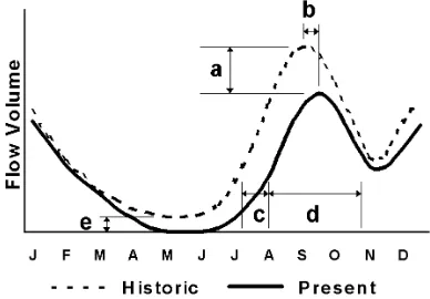
changes cannot be verified, much less quantified. However, for purposes of illustration, a conceptual representation of these possible changes has been constructed (Fig. 1).
Fig. 1: Theoretical representation of the possible changes in the natural flow regime of the Mocorito River at its mouth in Santa Maria Bay. Obvious elements of the historic regime include two seasonal peaks in river flow during the wet seasons (July-October and December-January) and a period of low flow during the dry season (April-June). The present flow regime represents suspected changes due to human activities in the watershed, including (a) a reduction in the magnitude of the seasonal inflow signal, (b) a temporal delay in the seasonal peak of the inflow signal, (c) a temporal delay in the initiation of the inflow signal, and (d) a reduction in the overall duration of the wet season inflow signal. A conjectural decrease in the amount of natural base flow during the dry season (see Footnote 16) is also represented (e).
Changes in the distribution of flow to the bay:
Historically, the most significant freshwater inflow to the bay was from the Mocorito Riverduring wet season. During the dry season, to the extentthat the
23 For a general presentation and discussion of how the
ecological integrity of river ecosystems depends on their natural dynamic character, including functional definitions of flow magnitude, timing, duration, etc., see Poff et al. 1997.
24 A CNA representative has stated there are only two
lower river did support a base flow, a small amount of fresh water would have also entered the bay. However, with the hydrologic alterations caused by the human activities, large amounts of water from the wet season are now stored in the reservoir and released slowly over time through the irrigation canal network. Eventually, a portion of this and other waters25 make their way from the canals onto
individual farms, and then off of the fields and into drainage ditches. The drainage ditches converge into major drains and discharge directly into Santa Maria Bay.
It is unknown whether the total volume entering the bay from irrigation return flows during the dry season is more or less than what historically entered via the river. The author suspects that the present return flow volume is substantially greater26. If this
assumption is valid, then there has likely been a meaningful increase in the total amount of
freshwater inflow to the bay during the dry season, as well as a change in its source location(s). Instead of experiencing minimal freshwater inflow during the dry season from one source (i.e., the Mocorito River), the estuarine zone of the Santa Maria Bay experiences artificially elevated freshwater inflows during the dry season (due to runoff from irrigated agriculture) from several sources27.
The effect of this change to the estuarine zone of Santa Maria Bay, if any, is not known. There is some evidence, however, that the upper reaches of the estuary associated with the main irrigation drainage ditches are experiencing much fresher conditions. By boat, the outlet of one of these major ditches28 was investigated during the field trip. It
25 As previously discussed, these waters can include
supplemental groundwater and discharged municipal effluent.
26 This conclusion is based on the fact that, during the dry
season, irrigation deliveries from Buelna Dam are relatively low, but are usually at least about 4 m3/ s. It is
unlikely, in the author’s opinion, that the Mocorito River was capable of this amount of natural flow during the dry season.
27 It may be important to also note that even during the wet
season, the source locations for freshwater inflow to Santa Maria Bay have been similarly changed. During the peak of the irrigation season (about mid-October), 20 to 25 m3/ s
is released into the irrigation canal from Buelna Dam alone. Combined with other canal flows diverted from the Culiacan River, the total freshwater signal into the estuary from the drainage ditches during the wet season could be significant.
28 The drainage ditch in question was located at the southern
end of Santa Maria Bay, and drains fields irrigated with water diverted out of the Culiacan River.
was observed that along the narrow channels of the upper estuary, either the mangroves were being displaced by vigorous growths of cattail (Typha
spp.) and bulrush (Scirpus spp.), or these freshwater species were out-competing mangroves in the colonization of newly created mudflats. Although the invasion of freshwater emergent vegetation was thought to be possibly associated with a large tropical storm event in 199729, it is also possible that
the artificially elevated and sustained volumes of freshwater provided to the upper estuary by the drainage ditches is actively supporting such invasions.
Changes in the natural sedimentation rate: Sedimentation is a natural function of river hydraulics. Lacking sufficient data for Mocorito River basin sediment processes, the author can only offer two hypothetical changes. First, it would seem intuitive that below Buelna Dam, the sedimentation rate has been significantly reduced due to the capture effect of the structure itself. In fact, approximately 10% of the total storage capacity of the reservoir (35 M m3) has been reserved for the
influx of sediment. Conversely, it would seem equally intuitive that the vast amount of land under cultivation in the State’s coastal plains would consequently increase the amount of soil lost to water erosion, thereby increasing the sedimentation rate to the bay. These suspected changes are speculative in nature, but are not inconsistent with general hydrologic principles. At present, the quantitative or relative change in the actual
sedimentation rate of the river or basin is unknown.
Changes in W ater Quality
There is local concern about the possible changes that have occurred to the quality of water resources in the Mocorito River basin, especially within the estuarine zone. Although there is reported some scattered data available on the subject, there is not a comprehensive
29 It is conceivable that a large flood event in the Sinaloa
sampling and analysis program currently in effect30.
Furthermore, what data that has been collected was not readily available for review during the site visit. Therefore, as with the speculative changes previously discussed regarding potential changes to the natural flow regime and sedimentation rates, the author is similarly reduced to discussing only the possible water quality changes that have occurred in the estuarine zone. Given the extent and type of human activity in the watershed, a myriad of potential water quality issues could be expected. From the author’s perspective, there are two primary areas of potential alteration: namely, the increase in nutrients and the addition of
manufactured toxins. Increased nutrients:
Increased nutrient loading to the Mocorito River was evident from observed direct discharge of untreated municipal effluent and livestock excrement into the river near Guamuchil. As most of the river water in the lower portions of the watershed is locally diverted for agriculture, most of this nutrient material ends up on an agriculture field. Irrigation return flows from these fields could contain remnant municipal nutrients as well as any number of fertilizer products applied by the grower. In many cases, it was observed that some of the irrigation return flow was returned to the river, only to be re-diverted again onto a field further
downstream. Ultimately, all irrigation return flows are discharged into Santa Maria Bay.
If there happens to be an aquaculture facility using this discharge water, then certain processes at this facility could also contribute nutrient materials. This aquaculture water is also eventually discharged into the bay.
Given these instances, the opportunity for multiple nutrient additions to the water resources of the Mocorito River basin is quite possible.
Introduction of manufactured toxins:
The primary potential source for the introduction of chemical toxins into the water resources of the Mocorito River is the application (and subsequent
30 In addition to the general lack of resources and capacity
for extensive water quality monitoring, there has been some level of (at least perceived) resistance to such investigations in the watershed. It is generally recognized that the local economic sectors representing individual and corporate growers, as well as agriculture chemical manufactures and distributors, are most sensitive to such analyses. Given the economic and political status of the agriculture industry as a whole in Sinaloa, this resistance would be anticipated.
runoff) of a variety of agriculture chemicals, specifically herbicides and pesticides.
Comprehensive information about the use of these chemicals (e.g., types of chemicals used, application rates, application methods, etc.) is almost non-existent for the State of Sinaloa. Furthermore, although some extensive national regulations31 do
exist regarding the use of agriculture chemicals, their enforcement is often inconsistent.
Other possible sources of toxic chemicals could include any mining activity in the upper basin or from municipal garbage. The potential contribution of these sources, however, is probably relatively insignificant compared tothat of agriculture chemicals.
DISCUSSION
Having summarized the general character of the Mocorito River basin and discussed its primary alterations by human activity, some effort can now be made to identify the primary human values placed on its water resources. From the author’s perspective, these values principally include its agricultural, coastal fishery
and municipal uses.
The following discussion, then, is based on the author’s (admittedly limited) perception of the most critical threats to these identified values. This section is then concluded with a summary of the strategy and status of CI-Mex’s activities in the region.
Perceived Threats
For each principle value, the primary perceived threats are identified and discussed.
AGRICULTURE
• Compromised production of agricultural land. This threat may be considered, to some degree, to be self-perpetuating. If, as suspected, the continued use of agriculture chemicals impairs the natural microbial processes in the soil that contribute to productive plant growth, then it is likely that more chemicals will be added to compensate for the reduction. This, in turn,may lead to further deteriorations in the soil’s natural ability to sustain productive plant life. In addition to being expensive, a significant dependence on fertilizers, herbicides and pesticides may limit overall crop production. However, very little information is presently available on the
31 These regulations have been primarily developed and
subject in the watershed, and the significance of this threat to the agricultural value of water for
irrigation is unknown. COA STA L FISHERY
• Unregulated harvest pressure on shrimp resources. Although numerous regulatory restrictions apply to the commercial shrimp industry in Sinaloa,
sufficient legal enforcement is generally lacking. For example, it is presently illegal to fish for shrimp in the Gulf of California outside of Santa Maria Bay, but this restriction is rarely enforced32. Ultimately,
harvest pressure must be effectively managed for a highly productive shrimp fishery to be reliably sustained.
• Current operation of Buelna Dam and reservoir. The significant degree of impact that reservoir
operations can have on the natural flow patterns of rivers is well documented33. The current operation
of Buelna Dam for irrigated agriculture potentially threatens the productivity of the coastal fishery of Santa Maria Bay in two principal ways. First, reservoir operation continues to impair the seasonal freshwater signal into the bay (i.e., the magnitude, timing and duration of inflow events). Second, reservoir operation may also be contributing to the loss of mangrove habitat from emergent marsh encroachment in the upper areas of the estuary. However, to the author’s knowledge, neither of these issues has been adequately studied to allow a reasonable estimate of the magnitude or scope of their potential threat to the coastal fishery34.
• Future diversions from the M ocorito River. One of the most serious threats, but possibly one less
immediate, is that of additional future development of the water supplies of the Mocorito River. Such
32 It is estimated that as much as 50% of the total annual
shrimp harvest of Santa Maria Bay is actually caught in the Gulf, and is therefore illegal.
33 Poff et al. 1997.
34 It is not anticipated that such a hydrologic analysis (which
could be as simple as a rudimentary water budget for the basin) would be excessively difficult to develop. Its benefits could potentially be many. First, it would allow the characterization and presentation of different aspects of the natural flow regime (e.g., flow magnitude, timing and duration) over a temporal scale (e.g., daily or monthly), similar to Fig. 1. Next, such an analysis could also be used to characterize the hydrographic changes in the Mocorito River basin over time, greatly assisting the assessment of historical impacts to the estuarine resources in Santa Maria Bay that have adapted to the historic patterns of freshwater inflow. Finally, this assessment could provide a foundation for insight and analysis of other issues (e.g., water quality changes) in the watershed.
development could be instigated in response to the needs of agriculture or growing municipalities, or both. For example, as previously discussed, the present operation of Buelna Dam does not supply the full amount allocated to agriculture (see Footnote 10). This implies an existing, unmet demand for additional irrigation water. Furthermore, the representative for the federal Mexican agency responsible for water development and management (CNA) stated that plans for a second dam in the Mocorito River basin upstream of Buelna Dam have been completed but that funding had not yet allocated for the project35. This
structure would provide an estimated additional 200 M m3 annually for irrigated agriculture in the
region. If constructed, this facility could be expected to further exaggerate the alterations to the natural flow regime of the Mocorito River into the bay, as well as amplify to the water quality issues by enabling a substantial increase in total irrigated area in the region.
• Contamination of freshwater inflow to the estuary. Because of the potential (by design) for nutrients and biocides to affect critical biological processes, the concern that sewage, fertilizers, herbicides and pesticides may affect the coastal fishery is
legitimate. Although specific data for pollution of the Mocorito River or Santa Maria Bay was not readily available, it is generally known that water contamination can and do impact aquatic
ecosystems. For example, pesticides are known to produce endocrine and reproductive damage in organisms, and high levels of nutrients can cause eutrophication in the lakesand rivers and continue on into coastal areas36. But again, the magnitude,
scope and extent of the threat of contamination in the estuary are difficult to determine without extensive review and analyses of existing data. • Altered sedimentation rate into the bay. The
contribution of river sediments to a bay is a natural process. In the case of the Mocorito River, this natural process has been altered by reservoir construction and regional land use practices. Significant decreases insedimentation could lead to the reduction in the impact of natural nutrient materials and the submergence of shallow water habitats. Significant increases in sedimentation
35 The exact status of funding for this facility was not
precisely clear. There was the general indication that if funding were to be made available, it might be several years from now.
36 Source: EduGreen, an educational initiative for schools by
could lead to turbidity problems and loss of shallow water habitats. Theoretically, either of these two conditions could threaten estuary productivity, but it is unclear which, if either, actually threatens the coastal fishery.
MUNICIPAL
• Public health risk from lack of water sanitation.
There are two main public health risks commonly associated with water quality degradation due to raw sewage contamination: fecal-oral (diarrhoeal) disease transmission and nitrate poisoning37. In the
Mocorito River basin, the discharge of raw municipal sewage and livestock excretions into the river contaminates both the surface and ground water resources of the watershed. Downstream communities then withdraw shallow groundwater or surface water from the river for municipal use. These circumstances pose a clear potential human health risk through two different possible exposure vectors; namely, direct contact and ingestion. • Public health risk from chemical contamination of source
water. Chemicals introduced into drinking water sources can cause serious health effects in humans. In the Mocorito River basin, the primary potential sources of surface and ground water contamination are from agriculture runoff and raw sewage. Chemical ingredients present in pesticides can affect and damage the human nervous, reproductive and endocrinal systems, and can cause cancer38.
Elevated levels of nitrates from either fertilizer or sewage can prove fatal to humans, especially to infants39. The actual public health threat from
chemical contamination of municipal source water in the Mocorito River basin is commensurate with the degree to which actual contamination has occurred, and if so, to the degree which these water supplies are treated and consumed. Unfortunately, these relationships are not presently well known.
CI-M ex’s Strategy for Addressing Threats
Given the short amount of time spent in the region and a very limited development assistance background, the author is reluctant to even attempt a discussion of CI-Mex’s activities in Sinaloa. Nevertheless, during the course of the time spent in Mexico, the author was exposed to and participated in a variety of CI-Mex’s activities in the Mocorito River basin and Santa Maria
37 Cave and Kolsky 1999.
38 Source: EduGreen, an educational initiative for schools by
the Tata Energy Research Institute (http:/ / edugreen.teri.res.in/ index.htm).
39 Ibid.
Bay. From this limited perspective, key elements of CI-Mex’s strategy for addressing the potential threats to the water resources of the basin were apparent.
The primary focus of CI-Mex’s activities in Sinaloa is the
local communities; or, those groups of people who either directly utilize water or who must bear some of the consequence for water management decisions. From these communities, CI-Mex has organized and facilitates a number of diverse working groups in several
locations, whose individual members include fishermen, residents, students, teachers, governmental officials, business representatives and others. Because of this diversity, the participants in these groups address the water resource issues of the basin from different points of view, but in an open, participatory process that encourages cross-pollination if ideas and mutual education.
The primary message presented to these groups by CI-Mex is that they have the ability to affect improvements in their watershed, and therefore in their lives. This emphasis on enabling local communities to take the initiative in identifying problems and coming up with solutions has significant strategic value. Primarily, it reduces dependency on government structure40 for
immediate intervention and mobilizes a far greater critical mass of human effort.
In the author’s (previously qualified) opinion, CI-Mex’s community-based approach, which is largely
independent of direct government support, appears to show promise for long-term results because it is broadly supported by substantial local interest and energy.
40 There appears to be some inherent difficulties in
establishing and maintaining strong, long-term political support and funding for local programs within the Mexican governmental system. The regional/ municipal governments are elected every three years, with no opportunity for the incumbents to be immediately re-elected. Similarly, the national government
CONCLUSIONS
The objective of this report was to provide a
cursory, w atershed perspective of the most
significant water-related issues in the Mocorito
River basin. In summary, the author is left with
the follow ing conclusions:
•
The inland and coastal w ater resources of
Sinaloa are important to both the economy of
the State and to the livelihood of its residents.
•
The primary human values placed upon these
w ater resources are primarily associated w ith
their agriculture, coastal fishery and municipal
uses.
•
There are several ongoing human activities in
the w atershed that threaten, to some degree,
the value of each of these uses.
Threats to agriculture use include the
compromised production of agricultural land.
Threats to coastal fishery use include
unregulated harvest pressure on shrimp
resources, current operation of Buelna Dam
and reservoir, future diversions from the
Mocorito River, contamination of freshw ater
inflow to the estuary, and an altered
sedimentation rate into the bay.
Threats to municipal use include public health
risks from lack of w ater sanitation and
chemical contamination of source water.
•
The magnitude and extent of these threats are
very much limited by the lack of sufficient
data and analyses.
•
CI-Mex’s community-based approach appears
to be reasonable and effective in better
understanding the present threats and in
developing and implementing potentially
viable solutions.
Acknowledgements
The author w ould like to acknow ledge the
following:
The University of Sinaloa
: for their kind receptions
in Guamuchil, Culiacan and Mazatlan.
A riel
and
Beto: for a great tour of the bay and a
very good lunch.
Freddie, Sammy, Joel
and
George: for world-class
ulama
lessons.
A rmando
and
A nna: for great food, company,
Spanish lessons and overall interpretive
services.
Sources Cited
CA VE, BEN andPETE KOLSKY. 1999. Groundwater,
latrines and health. WELLstudy Task No. 163. London School of Hygiene and Tropical Medicine, WEDC, Loughborough University, UK.
FAO. 1998. Soil and terrain database for Latin America and the Caribbean, 1:5 million scale, FAO, Land and Water Digital Media Series N°5. Food and
Agriculture Organization, Rome, Italy.
GA LLEGOS, M. 1986. Petróleo y manglar. Serie Medio
Ambiente en Coatzacoalcos Vol. III. Centro de Ecodesarrollo , México .
GENTRY, A.H. 1995. Diversity and composition of
neotropical dry forests. Seasonally dry tropical forests. S.H. Bullock, H.A. Mooney, and E. Medina, editors. Cambridge University Press, Cambridge. HORWICH, R.H., and J. LYON. 1990. A Belizean rain
forest: the community baboon sanctuary. Orang-utan Press. Gays Mills, Wisconsin.
OLSON, DAVID M., ERIC DINERSTEIN, ERIC D.
ecoregions of the world: a new map of life on earth.
BioScience, Vol. 51, No. 11.