Conservation in Practice
346
Conservation Biology, Pages 346–359
Quantitative Changes in Forest Quality in a Principal
Overwintering Area of the Monarch Butterfly in Mexico,
1971–1999
LINCOLN P. BROWER,*†† GUILLERMO CASTILLEJA,† ARMANDO PERALTA,‡
JOSE LOPEZ-GARCIA,‡ LUIS BOJORQUEZ-TAPIA,§ SALOMON DIAZ,§
DANIELA MELGAREJO,§ AND MONICA MISSRIE**
*Department of Zoology, University of Florida, Gainesville, FL 32611, U.S.A.
†Endangered Spaces Program, World Wildlife Fund, 1250 24th Street NW, Washington, D.C. 20037, U.S.A. ‡Instituto de Geografia, Universidad Nacional Autonoma de México, México D.F., 06170, México
§Instituto de Ecologia, Universidad Nacional Autonoma de México, México D.F., Apartado Postal 70–725, México D.F. 06170, México
**Department of Conservation Biology, University of Minnesota, St. Paul, MN 55108, U.S.A.
Abstract: Degradation of the oyamel fir-pine forest ecosystem in central Mexico is a threat to the overwinter-ing and migratory phenomenon of the eastern North American population of the monarch butterfly (Danaus plexippus). Because a lack of quantitative data has hindered effective conservation policy, we photogram-matically analyzed the changing state of a major overwintering forest area. We analyzed stereographic aerial photographs of a 42,020-ha area taken in 1971, 1984, and 1999 with GRASS, a geographic informa-tion system. What in 1971 was a nearly continuous high-quality forest is now fragmented and severely de-graded. Between 1971 and 1999, 44% of conserved forest ( forest with 80% cover) was degraded, and the largest patch of high-quality forest was reduced from 27,115 ha to 5827 ha. The annual rate of degradation from 1971 to 1984 was 1.70%, and this increased to 2.41% during the next 15 years. At the latter rate, 10,000 ha of high-quality forest will remain in 20 years and 4,500 ha in 50 years. A subset of the analysis quantified changes in a 6596-ha area on the Sierra Chincua, Sierra Campanario, and Cerro Chivati Huacal massifs that were declared protected by presidential decree in 1986. Corresponding rates of degradation of these reserves more than tripled, from approximately 1.0% between 1971 and 1984 to more than 3% between 1984 and 1999. Passage of the 1986 decree failed to protect the forest. Our data provide irrefutable evidence that successful implementation of a more inclusive presidential decree issued in November 2000 will require (1) effective enforcement against logging within the oyamel-pine forest ecosystem and (2) restoration of ar-eas that have been degraded. All indications are that the rate of logging is incrar-easing throughout the area. The grandeur of the monarch butterfly overwintering phenomenon in this tiny area of Mexico is too great a cultural and biological treasure for this rampantly destructive process to continue.
Cambios Cuantitativos en la Calidad del Bosque en un Área Principal de Hibernación de la Mariposa Monarca en México, 1971 a 1999
Resumen: La degradación de los ecosistemas de bosque de oyamel-pino en México central es una amenaza para el fenómeno de hibernación y migratorio de la población de mariposa monarca (Danaus plexippus) de Norte américa oriental. Debido a que la carencia de datos cuantitativos ha limitado la aplicación de políti-cas efectivas, analizamos fotogramáticamente los cambios en un área de hibernación principal. Analizamos fotografías aéreas estereográficas de una superficie de 42,020 ha tomadas en 1971, 1984 y 1999 con GRASS, un sistema de información geográfica. Lo que en 1971 era un bosque de alta calidad casi continuo, actual-mente esta fragmentado y severaactual-mente degradado. Entre 1971 y 1999, el 44% de bosque conservado (bosque
Brower et al. Deforestation of Monarch Butterfly Winter Site 347
Introduction
Each fall, the eastern North American population of 100– 500 million monarch butterflies (Danaus plexippus L.) migrates to central México. Here they form dense winter-ing clusters on the boughs and trunks of trees growwinter-ing in a high-elevation boreal-forest-like ecosystem dominated
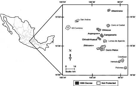
by the oyamel fir (Abiesreligiosa) (reviews by Brower 1995a, 1999a). Colonies, varying in size from about 0.5 to 5 ha, occur between 2400 and 3500 m on 12 mountain massifs in a small area of the central region of the trans-verse neovolcanic belt between latitudes 19o N and 20o N (L.B.-T. et al. and L.P.B. et al., unpublished data) (Fig. 1). The total forest area of the 30 or so known overwintering
con 80% de cobertura) fue degradado, y el fragmento mayor de bosque de alta calidad se redujo de 27,115 Ha a 5,827 Ha. La tasa anual de degradación de 1971 a 1984 fue de 1.70%, y se incrementó a 2.41% durante los 15 años siguientes. A esta tasa, 10,000 Ha de bosque de alta calidad permanecerán en 20 años y 4,500 Ha en 50 años Un subconjunto del análisis cuantificó los cambios en un área de 6,596 Ha en las cordilleras de Sierra Chincua, Sierra Campanario y Cerro Chívati Huascals que fueron declarades como protegidas por decreto presidencial en 1986. Las tasas de degradación de estas reservas se triplicaron, pasando de aproxima-damente 1.0% entre 1971 y 1984 hasta más de 3% entre 1984 y 1999, El decreto de 1986 no protegió el bosque. Nuestros datos proporcionan evidencia irrefutable de que la instrumentación exitosa de un decreto presidencial más incluyente promulgado en noviembre de 2000 requerirá de (1) vigilancia efectiva contra la tala dentro del ecosistema de bosque oyamel – pino y (2) la restauración de las áreas que hansido degradadas. Todo indica que la tasa de deforestación en el área esta incrementando. La magnificencia del fenó-meno de hibernación de la mariposa monarca en esta pequeña área de México es un tesoro cultural y bi-ológico muy grande como para permitir que este proceso destructivo continúe.
348 Deforestation of Monarch Butterfly Winter Site Brower et al.
Conservation Biology
sites varies annually from 10 to perhaps 25 ha, an area less than one-millionth that of the butterflies’ spring and sum-mer breeding ranges (Brower 1999b).
The fir ecosystem grades into pines at lower elevation and coincides with a 2400- to 3600-m cloud belt that forms around the peaks and enshrouds the forest with moisture during the summer wet season. Because this forest occurs within the tropics at high elevation, it vides a relatively stable microclimatic envelope that pro-tects the butterflies from freezing due to radiational heat loss on clear, cold nights. The forest also protects the butterflies from severe rain, snow, and windstorms that occur when cold fronts penetrate the Tropic of Cancer. Adiabatic rainfall, together with fog condensation on the fir and pine boughs, provides moisture that prevents the butterflies from desiccating as the dry season advances during the 5-month overwintering season. Researchers have determined that the forest canopy must be rela-tively intact to maintain the microclimatic envelope that protects the butterflies from freezing, wind-buffeting, excessive wetting, and desiccation (Anderson & Brower 1996; reviews by Brower 1996, 1999b, 1999c).
Shortly after the overwintering forests were discov-ered in 1975 ( Urquhart 1976; Brower 1995a, 1999a), numerous authors warned of their degradation due to in-dustrial logging, charcoal production, domestic use, and the expansion of agricultural fields. Consequently, in 1980 President Jose Lopez-Portillo issued a proclamation declaring all overwintering areas of the monarch butter-fly in Mexico as wildlife reserves and refuge zones that would be protected from all uses for an indefinite period of time (Lopez-Portillo 1980). Because of this proclama-tion’s vagueness, Mexican federal agencies (Rodriguez 1984); scientists (Brower 1985; Calvert et al. 1989; Melo-Gallegos & Lopez-Garcia 1989); environmental organiza-tions such as Monarca AC, The World Wildlife Fund, and The Group of 100 (in Aridjis 2000); and H.R.H Prince Philip, Duke of Edinburgh (Ogarrio 1984; Pyle 1984), called for a specific conservation plan. On 9 October 1986, President Miguel de la Madrid (de la Madrid 1986) issued a decree protecting 16,110 ha of forest on 5 of the 12 mountain ranges (Fig. 1).
Although this decree was an important attempt to conserve the overwintering phenomenon, understand-ing of the ecological needs of the monarch was incom-plete. Subsequently acquired data, for example, indi-cated that many colonies formed outside of the reserves, and large areas that were included in the reserves never hosted colonies (L.B.-T. et al., unpublished data). Of par-amount importance from the biological point of view was the realization that the 1986 decree had not ade-quately protected the overwintering phenomenon in the context of the oyamel-pine forest ecosystem.
Moreover, the continued cutting of trees in and adjacent to the butterfly colonies elicited accusations of illegal log-ging, failure to enforce existing laws, and claims of the in-effectiveness of overlapping governmental-agency
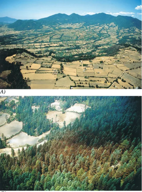
mis-sions (Manzanos 1997; Hernandez & Vera 1999). Paralysis of conservation also resulted from pitting the economic needs of local human populations against the ecological re-quirements of the butterflies (Chapela et al. 1995; Hoth 1995 vs. Brower 1995b; Merino 1997, 1999; Merino & Ala-torre 1997). Qualitative evidence of the general ineffective-ness of the earlier decree is evident in photographs, which show the general expansion of agricultural fields into the oyamel-pine ecosystem (Fig. 2a), specific encroachment onto the border of the Campanario Reserve (Fig. 2b), and time-documented deforestation on the southeastern bor-der of the Chincua Reserve (Fig. 3a & 3b).
Recognizing the socioeconomic difficulties and the ecological inadequacies of the earlier decree, and under the auspices of the North American Free Trade Agree-ment (NAFTA), the governAgree-ments of Mexico, Canada, and the United States authorized the North American Com-mission for Environmental Cooperation (CEC) to assem-ble academicians, artists, campesinos, educators, and journalists to address problems and search for solutions at an international symposium in Morelia, Michoacan, in November 1997 ( Hoth et al. 1999a,1999b). The princi-pal conclusion of the symposium was affirmation that forest exploitation, the needs of the local people (Alonso-Mejia & Alonso 1999; Barkin 1999; Hoth 1999; Masera et al. 1999; Merino 1999), and the biological re-quirements of the overwintering monarch butterflies (Anderson & Brower 1996; Alonso-Mejia et al. 1997) re-main in severe conflict.
Following the Morelia meeting, the Mexican Ministry for the Environment, Natural Resources and Fisheries (SEMARNAP) requested the National Ecology Institute (INE) to review the social and ecological efficacy of the 1986 presidential decree. In February 1998, INE in turn asked World Wildlife Fund–Mexico ( WWF ) to assist in addressing the biological issues. This resulted in an inter-national workshop in the Mexico City offices of the WWF during October 1998 that assembled monarch sci-entists from Canada, Mexico, and the United States. Our main charge was to synthesize up-to-date biological in-formation and develop a revised conservation plan to as-sure the long-term survival of the monarch butterfly overwintering phenomenon in Mexico. An additional outcome of the workshop was recognition of the neces-sity to quantify the extent and rate of degradation of the oyamel-pine forest ecosystem.
Brower et al. Deforestation of Monarch Butterfly Winter Site 349
350 Deforestation of Monarch Butterfly Winter Site Brower et al.
Conservation Biology
Brower et al. Deforestation of Monarch Butterfly Winter Site 351
Methods
We analyzed conventional aerial photographs and digital images with standard photogrammetry and by GIS analy-sis in GRASS (Geographic Resources Analyanaly-sis Support System, version 4.2, U.S. Army Corps of Engineers 1998). We used GRASS rather than other GIS programs because much of the original data were in this format.
We performed two separate analyses. The first digitized the data for a 42,020-ha (420.2-km2) area photographed
in 1971, 1984, and 1999. The area is bounded by the co-ordinates 194347 N, 1002038 W and 193000 N, 1001015 W, as shown on the 1:50,000 topographic maps for Angangueo (Cetenal 1987) and Ciudad Hidalgo (Cetenal 1976). The approximate elevational range within the area analyzed was 2100–3600 m. The second analysis, a 6596-ha subset of the first, included the data for three of the five 1986-decreed reserves in the Chincua, Campa-nario, and Chivati Huacal mountain massifs (Fig. 1) that occur in the center of the 42,020-ha region.
Aerial Images
Melo-Gallegos and Lopez-Garcia (1989) carried out a qualitative vegetation study that utilized 32 conventional black-and-white aerial stereographic photographs taken in 1971 and 1974. They did not cite the dates the photo-graphs were taken; here we correct this omission (Table 1). They defined three deforestation categories (see be-low) that we used for the time periods in this study. We digitized and further analyzed their data following the procedures described below. Because most of the pho-tographs were taken in 1971, we designated 1971 as the first time period in our study. We used the same meth-odology to analyze 47 aerial photographs taken of the
same region in December 1983 (Table 1) and designated 1984 as the second time period in our study.
For our third analysis, we obtained 334 digital images on 23 and 24 January 1999. Peralta (third author), to-gether with his experienced crew, flew 10 paths with 60% longitudinal overlap and 30% overlap between lines to obtain stereo images with a Kodak DCS 420 digital camera. We fitted the camera with a Sigma 14-mm lens, set at F 3.5; manually focused it at infinity; set it to man-ual exposure, SP Program (effective film speed ISO
100); and mounted it on a Cessna 206 aircraft outfitted for aerial photography. The plane was flown at approxi-mately 80 knots and maintained at an altitude of 5600 m to obtain images at a scale of 1:15,000. Bubble levels mounted on the floor of the plane and on the camera as-certained that the images were taken when the plane was level; we suspended photography during turbu-lence. We downloaded the images from camera memory and numbered and labeled each with the flight line and direction (north to south or south to north). We color-adjusted all images in Adobe Photoshop version 3.0 and printed them on paper (12.9 19.5 cm) with a four-color ink-jet printer at 600-dpi resolution. We designated 1999 as the third time period in this study.
We set the area of our vegetation maps and the frag-mentation analyses for all three dates to 42,020 ha. (i.e., the area approximately as mapped for 1971 by Melo-Gal-legos & Lopez-Garcia 1989). All aerial images were taken during mid-dry season, when the likelihood of cloud cover and storm turbulence is minimal.
Creation of the GIS Data Layers
Quantification of the changes in the states of the forest in-volved four general steps: (1) Based on stereoscopic exam-ination of the aerial images, we qualitatively designated three categories of forest status as conserved, semialtered, or altered. (2) We then circumscribed each patch of forest according to category with a closed, hand-drawn polygon on an acetate sheet that we overlaid on the aerial images. (3) We stereoscopically transferred the polygons onto a base topographic map. (4) We digitized the data.
We initially transferred the 20-m contour lines and UTM ( Universal Transverse Mercator) coordinates onto base maps by making 40 40 cm negatives of the two 1: 50,000 topographic maps. Paper or clear acetate maps were then printed from these at scales corresponding to scales of the original aerial images.
For each of the three dates, we sequentially numbered all overlapping aerial images taken along the parallel flight lines and covered each with a small, clear acetate sheet to allow inking of information with a fine-point felt marker. We determined the geometric center of each image as the point of crossing of diagonal lines drawn from corner to corner over the image. We then drew a third line through the geometric center point from left to right to allow
Table 1. Information on aerial photographsa
taken in the 1970s (n 32) and 1984 (n 47) that were used in the analyses of
Mexican forests where monarch butterflies overwinter.
Date Area Film Flight lines Photo nos.
1971b
D.F. 151.96 — 307 Odd 85–113
D.F. 151.96 — 308 Even 144–162
D.F. 151.96 — 308 Even 288–298
D.F. 151.96 — 309 Odd 261–279
D.F. 151.96 — 309 Even 250–260
aPhotographs are 23 23 cm.
bFrom the federal Comision de Estudios del Territorio Nacional
(CETENAL). Scale: 1:50,000.
c1974
dFrom the federal Instituto Nacional de Estudistica, Geografia
352 Deforestation of Monarch Butterfly Winter Site Brower et al.
Conservation Biology
stereo-alignment of sequential pairs of images along the parallel flight lines. A fourth line drawn perpendicularly to the flight line from the top to the bottom of each image through the center point allowed lateral alignment of the respective image pairs along the adjacent flight lines. We then used a Wild Mirror Stereoscope to stereoscopically view the overlapping sections of the aligned pairs of im-ages. This allowed us to bound the areas of useful resolu-tion so that distorresolu-tion and inclinaresolu-tion errors were mini-mized during restitution.
By stereo-viewing adjacent image pairs, we identified three categories of decreasing forest density as defined by Melo-Gallegos and Lopez-Garcia (1989): (1) con-served forest, patches in which the forest cover exceeds 80% (the forest was mostly closed and continuous but may have had small openings caused by natural or hu-man disturbance); (2) semialtered forest, patches in which the forest cover was between 30% and 80%, with various degrees of deforestation, lower tree density, and considerable fragmentation; and (3) altered forest, patches in which the forest cover was 30% (i.e., se-verely deforested, with small, dispersed fragments of conserved or semialtered forest remaining). The third category included encroachments such as small human settlements, agricultural fields, and pastures.
Each discrete forest patch on the stereo-images was circumscribed with a felt marker, and each resulting polygon was numbered and designated as conserved, semialtered, or altered. Full contiguity of all polygons was mandatory, and all data code entries were verified.
We used Stereosketch (Hilger and Watts, New York) to restitute the polygons on the stereo sections of adjacent image pairs (i.e., to align them into correct geographic positions by projection onto the base map). This device allows simultaneous three-dimensional viewing of stereo pairs and monocular viewing of the base map with its 20-m contour lines and coordinates. We adjusted the stereo-image pairs to correct for inclination by using the center points and flight lines to facilitate alignment. The images were also corrected for variations in distance from the ground surface due to the mountainous topography. Once each polygon was restituted, we manually traced it onto the paper base map and indicated its vegetation cate-gory. All the data in our vegetation analyses were in a ras-ter format; no vectorized data were used. We used a Summa Sketch III Professional digitizing tablet to register the UTM coordinates, the 20-m contour lines, the cor-rectly positioned vegetation polygons, and their status as conserved, semialtered, or altered forest.
The next data layer, provided by Procuraduria Federal de Protección al Ambiente (PROFEPA) (Anonymous 1997), included the coordinates for the inner core and outer buffer-zone boundaries of the five reserves decreed in 1986: Altamirano, Chincua, Campanario, Chivati Huacal, and Cerro Pelon (five darkened concentric polygons in Fig. 1). The clear concentric polygons in Fig. 1 are core and buffer-zone boundaries that PROFEPA proposed for seven additional massifs where overwintering monarch colonies occur regularly. These seven polygons were un-fortunately not included in the 1986 or 2000 decrees.
The final data layer compiled the coordinates of all monarch butterfly overwintering locations recorded by investigators over 22 wintering seasons from 1976–1977 through 1997–1998. The data are from Calvert and Brower ( 1986 ), PROFEPA (Anonymous 1997 ), and L.P.B. et al. (unpublished).
After displaying and correcting closure and other er-rors, we made color-coded printouts of the maps to ver-ify the vegetation categorizations for the three time peri-ods. Our ground-truthing was largely qualitative: none was done for the 1971 analysis, but we made qualitative ground checks with topographic maps during the summer of 1985. In May 1999 we returned to the area and verified 120 vegetation polygons with a Magellan 1500 global-positioning device and base and topographic maps. Based on this effort and overall stereo-image quality ( Fig. 4), we are confident that our categorizations are accurate.
Once all the digital layers were corrected, we used a GIS to rasterize the information and manipulate the data mathematically, including changes in map scale and cal-culations of the areas occupied by conserved, semial-tered, or altered forest for each time period. We used a subprogram of GRASS to analyze habitat fragmentation and calculate the numbers and areas of forest patches for the three time periods (Baker & Cai 1992).
The minimum area that can be mapped at any scale on our digitizing tablet was 0.5 0.5 cm (i.e., 0.25 cm2). The scale of the printed aerial photographs for the 1971 study was 1:50,000, in which 1 cm 500 m. At this scale, 0.5 0.5 cm is equivalent to 250 250 m (62,500 m2; i.e., the minimal polygon size we could digi-tize represented 6.25 ha). The photographs for the 1984 study were printed at a scale of 1:37,000, in which 1 cm
370 m, so that the minimum area represented by 0.25 cm2 was 185 185 m (34,225 m2; i.e., the minimal poly-gon size was 3.42 ha). In contrast, the scale of the 1999 digital images was 1:13,000, in which 1 cm 130 m, so that the minimum area represented by 0.25 cm2 was
354 Deforestation of Monarch Butterfly Winter Site Brower et al.
Conservation Biology
65 65 m (4225 m2; i.e., the minimal polygon size was 0.4225 ha). Therefore, the base resolution of the 1999 digital images was 8.1 and 14.8 times more detailed than the 1984 and 1971 aerial photographs, respectively (i.e., 3.42 ha and 6.25 ha, divided by 0.4225 ha).
The higher resolution and better stereo-imaging capa-bility of the 1999 digital photographs allowed us to define forest-quality categories in much more detail (26 vegeta-tion states) than in the 1971 and 1984 photographs. But to avoid errors in estimating changes in the areas of the vegetation in the three categories and in the extent of fragmentation, we used a GIS to adjust the 1999 and 1984 resolutions downward to the lower 1:50,000 1971 scale and analyzed only the three original vegetation states. We also excluded all forest patches that were 10 ha before plotting the polygon data. Thus, our data ( Table 2) and map comparisons for the 3 years (Fig. 5) are conservative and underestimate the extent of both forest fragmenta-tion and degradafragmenta-tion. We saved all three maps as bitmap files and printed them from Adobe Photoshop.
Rates of Reduction of the Conserved-Forest Category
We calculated the mean annual rates of conversion from the conserved forest category to the semialtered and al-tered categories from 1971–1984, 1984–1999, and the entire period 1971–1999. Arithmetic mean rates (R) were calculated as follows, where N is the number of years between the two intervals:
(1)
To project these rates into the future, we recalculated them using the geometric-decay function of Dirzo and Garcia (1992). Accordingly, the geometric rate of defor-estation (r), where n is the number of years between two successive measurements, was calculated as
(2)
We then used r as derived from Eq. 2 to predict the area of forest remaining (AFR) at time t in the future:
. (3)
Results
Qualitative Description of the Changing States of the Forest
The results of the three aerial surveys spanning the pe-riod from 1971 through 1999 indicate severe forest deg-radation ( Fig. 5 ). The 1971 panel reflects the rationale for the boundaries of the three monarch butterfly over-wintering reserves decreed in 1986. Conserved, high-quality forest predominated in the Chincua, Campanario and Chivati Huacal reserves. Extensive areas of con-served forest surrounded and interconnected the three
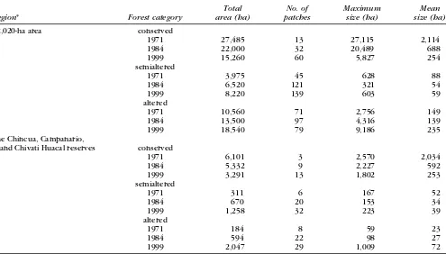
R 1⁄N(area at time 1–area at time 2) Table 2. Fragmentation of the forest: temporal changes in sizes (ha) and numbers of patches in three forest categories.
Region* Forest category
1971 27,485 13 27,115 2,114
1984 22,000 32 20,489 688
1999 15,260 60 5,827 254
semialtered
1971 3,975 45 628 88
1984 6,520 121 321 54
1999 8,220 139 603 59
altered
1971 10,560 71 2,756 149
1984 13,500 97 4,316 139
1999 18,540 79 9,186 235
The Chincua, Campanario,
and Chivati Huacal reserves conserved
1971 6,101 3 2,570 2,034
1984 5,332 9 2,227 592
1999 3,291 13 1,802 253
semialtered
1971 311 6 167 52
1984 670 20 153 34
1999 1,258 32 223 39
altered
1971 184 8 59 23
1984 594 22 98 27
1999 2,047 29 1,009 72
Conservation Biology
Volume 16, No. 2, April 2002
Brower et al.
Deforestation of Monarch Butterfly Winter Site
355
Figure 5. Changes in forest cover from 1971 to 1984 to 1999 in a 42,020-ha region of central Mexico that includes three of the 12 known massifs that
serve as overwintering areas for the monarch butterfly. Three categories of forest quality are shown: conserved forest cover 80%; semialtered forest
cover 30–80%; altered forest cover 30%. Numbers are the (1) Chincua, (2) Campanario, and (3) Chivati Huacal reserves depicted in the center of Fig. 1.
356 Deforestation of Monarch Butterfly Winter Site Brower et al.
Conservation Biology
reserves, and there was minimal forest fragmentation. Semialtered and altered forests were limited to the envi-rons surrounding the mining town of Angangueo and the heavily inhabited area on the southwestern side of the Campanario Reserve.
Between 1971 and 1984, widespread forest alteration occurred in the areas adjacent to and between the re-serves ( Fig. 5 ). Large contiguous areas that had been semialtered were degraded to altered, and several areas within the intact forest were thinned, resulting in sub-stantial shifts from continuous conserved forest to frag-ments of semialtered forest (Diaz 1996). Substantive in-cursions took place in the eastern part of the Chincua reserve. Both the core and buffer zones of the Campa-nario Reserve were subject to patchy harvesting (Fig. 5). Major harvesting on the southern flanks of the Chivati Huacal Reserve occurred, and some reduction from con-served to semialtered forest occurred within the eastern core zone. Considerable reduction from conserved to semialtered forest and fragmentation of the forest corri-dors between the three reserves occurred.
Between 1984 and 1999 ( Fig. 5 ), severe forest alter-ation occurred both within and adjacent to the three re-serves, notwithstanding the decree mandated on 9 Octo-ber 1986. Clearing in the buffer zone along the southern border of the Chincua reserve reduced most of the con-served forest to altered forest ( Fig. 4a ), and there was substantial thinning within the core area in and adjacent to the known locations of butterfly colonies. Much of the conserved forest in the Campanario Reserve was de-graded to semialtered patches. Major clearcutting in and adjacent to the Chivati Huacal Reserve removed the for-est that had hosted nearly all the former butterfly over-wintering sites ( Fig. 4c). Comparison of the 1984 and 1999 maps documented extensive degradation of the previously conserved forest corridors that connected the three reserves. This comparison also revealed severe forest fragmentation and degradation on the eastern side of the butterfly overwintering massifs. Partial forest re-covery in some areas also occurred—for example, imme-diately south of the Chivati Huacal Reserve (Figs. 4d & 5).
Quantitative Analysis of the Changing Forest Quality
Between 1971 and 1984, in the 42,020-ha area there was a 20% reduction (5485 ha) in the conserved-forest cate-gory, and between 1984 and 1999 a further 6740-ha were thinned and cleared (Table 2). Thus, over the 28-year period, 44% (12,225 ha) of the conserved forest was converted to the semialtered or altered categories. Deterioration of the conserved forest over the 28-year period was also indicated by the increasing number of patches and by their changing maximum and mean sizes ( Table 2). During this time, the number of conserved-forest patches increased from 13 to 60, and their mean size decreased from 2114 to 254 ha. Maximum patch
size also changed from 27,115 to 5827 ha, a decrease of
75%. As the conserved category was diminishing, the number of semialtered patches tripled. This magnitude of change was also indicated in the altered-forest cate-gory: mean altered patch size increased from 149 to 235 ha, and the maximum altered patch size increased more than three-fold, from 2756 to 9186 ha. The number of patches in the altered-forest category increased from 1971 to 1984, but then decreased between 1984 and 1999 because of their merging into larger, continuous areas of altered forest.
The changes in landscape in the three reserve areas that were decreed as protected in 1986 were similar to those in the entire area ( Table 2). Both the mean and maximum size of the conserved-forest patches dwindled as altered patch size increased. Simultaneously, the num-bers of patches in all three forest categories increased over time. Forest degradation accelerated after the de-cree was enacted. Thus, from 1971 to 1984, 769 ha (13%) of conserved forest were degraded, and from 1984 to 1999, 2041 ha (38%) were degraded, averages of 59 and 136 ha per year, respectively.
Rates of Reduction of the Conserved-Forest Category
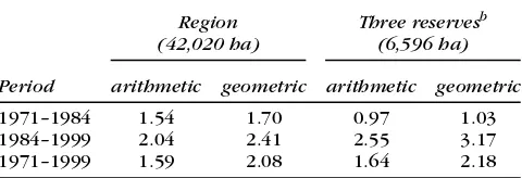
The annual geometric rate of loss of the conserved for-est in the 42,020-ha region was 1.70% between 1971 and 1984 and increased to 2.41% between 1984 and 1999 (Table 3). For the three reserves, the geometric rates for the same periods more than tripled, from 1.03% to 3.17%. These values reinforce our finding that, since the 1986 decree was enacted, more forest degradation has occurred in the reserve areas than in the general region.
Actual and Projected Reduction of the Conserved-Forest Category
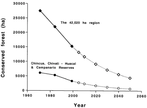
The first three points of the two lines in Fig. 6 are data from Table 2 for the number of hectares in the con-served-forest category for 1971, 1984, and 1999. We used the geometric decay equation (equation 3) to project the decreases of conserved-forest from 1999 through 2050 ( Fig. 6 ). If current practices continue in
Table 3. Annual rates of decrease (percent per year) of the conserved-forest category for the three time periods, calculated as mean annual arithmetic rates and as geometric-decay rates.a
Period
1971–1984 1.54 1.70 0.97 1.03
1984–1999 2.04 2.41 2.55 3.17
1971–1999 1.59 2.08 1.64 2.18
Brower et al. Deforestation of Monarch Butterfly Winter Site 357
the region, the remaining 15,260 ha of conserved forest will dwindle to 9144 ha by 2020 and to 4399 ha by 2050 (i.e., losses from 1971 of 67% and 84%, respectively). In the three reserves, the current 3291 ha of conserved for-est will dwindle to 1675 ha by 2020 and to 638 ha by 2050 (i.e., losses from 1971 of 63% and 90%, respectively).
Discussion
A quantitative breakdown of the various causes of this forest degradation has not been made, but they include conversion of forest to agriculture and pastures, exces-sive commercial logging (legal and illegal), uncontrolled harvesting of wood for domestic use, charcoal produc-tion, and damage from periodic agricultural fires escap-ing into adjacent forests (Snook 1993; Brower & Missrie 1998). Illegal browsing and grazing by cattle and sheep add to the deterioration by preventing forest regenera-tion (Rendon-Salinas 1997).
Our projected rates of forest degradation are undoubt-edly underestimates, because qualitative observations in the area indicate that logging rates are sharply increas-ing. Helicopter reconnaissance in February and March 1999 and ground reconnaissance through the fall of 2000 found extensive logging activities, numerous new sawmills, and accelerating industrial production. For ex-ample, Rexcel, a major particleboard and laminate wood company, has a manufacturing plant located in the heart of the overwintering area along Highway 15 south of
An-gangueo and west of Zitacuaro. Its current wood con-sumption is 350,000 m3 per year, and consumption is predicted to increase (Rexcel 2000, unpublished data). Although this plant is said to purchase most of its wood from other regions of Mexico, it constitutes a virtually unlimited buyer of wood chips.
For eight states in southern Mexico, Cairns et al. (2000) estimated a mean annual deforestation rate of 1.9% between 1977 and 1992. We determined that the oyamel-pine forest ecosystem in the major area of mon-arch butterfly overwintering is being degraded even faster, at the rate of 2.41% in the general area and 3.17% in the three 1986-decreed reserves. Over the past 15 years, 31% and 38% of the high-quality forest in the re-gion and three reserves, respectively, have been de-graded.
Our findings reflect the limitations of mandated pro-tection decrees as deterrents to habitat degradation. Liu et al. (2001) found a similar degradation in the Wolong giant panda reserve in southwestern China, where the rate of habitat loss and fragmentation accelerated after creation of the reserve. As in the monarch butterfly re-serves, this degradation is associated with continued un-controlled extractive activities by local communities af-ter the reserve was created. Examples such as these two “flagship” reserves demonstrate the need for conserva-tion schemes that take into account land and resource tenure by local communities. Studying 92 protected ar-eas in 22 countries, Bruner et al. (2001) demonstrated that the effectiveness of protected areas in the tropics is largely a function of enforcement, boundary demarca-tion, and direct compensation to local communities.
Our results demonstrate quantitatively what has been qualitatively evident since 1977, namely that wood har-vesting in the oyamel-pine forest ecosystem of central Mexico is extensive and accelerating. Our new data pro-vide compelling epro-vidence that the microclimate charac-teristics of the oyamel-pine forest ecosystem are in immi-n e immi-n t d a immi-n g e r o f u immi-n r a v e l i immi-n g . T h e o v e r w i immi-n t e r i immi-n g phenomenon of the monarch butterfly in Mexico will deteriorate and possibly collapse totally if this ecosystem is not effectively protected and restored.
Finally, as reported on 12 September 2000 in the New York Times (Yoon 2000) and in Reforma (Millan 2000), our data convinced SEMARNAP to revise and extend the areas that had been defined as protected under the 1986 presidential decree. Shortly thereafter, on 9 November 2000, most aspects of our proposal under the World Wildlife Fund–Mexico for a new ecosystem-based re-serve (L. B.-T. et al., unpublished data) were decreed as law by President Ernesto Zedillo ( Medina 2000; Zedillo 2000). This new decree expanded the monarch butter-fly reserve system from 16,110 to 56,259 ha. In addition, the government approved and will help implement a new multimillion-dollar trust fund, the interest from which will be used to compensate local inhabitants for
358 Deforestation of Monarch Butterfly Winter Site Brower et al.
Conservation Biology
relinquishing their wood rights and to help them shift to conservation-based economies.
However good this news may seem, we end with a ca-veat: signing additional presidential decrees per se is in-sufficient. What is required is a consensual but binding agreement on limits to the extraction and use of forest products and effective enforcement linked with appro-priate compensation to local communities. Field obser-vations (Bruner et al. 2001) suggest that once anthropo-genic pressure is reduced to a minimum, the oyamel-pine forest could be capable of naturally restoring most of its original structure and function in a matter of decades. The grandeur of the monarch butterfly overwintering phenomenon in this tiny area of México is too great a cultural and biological treasure for the current rampantly destructive process to continue.
Acknowledgments
We are grateful for support from The Wildlife Conserva-tion Society of New York, The Rufford FoundaConserva-tion–UK, the World Wildlife Fund (WWF)-Canada, The Monarch Butterfly Sanctuary Foundation, Scion Natural Science Association, Universidad Nacional Autonoma de México, The University of Florida, and Sweet Briar College. We also thank K. Reinhold, P. Reinhold, and an anonymous donor for generous support. For manuscript critiques, we are grateful to L. Fink of Sweet Briar College, D. Per-ault of Lynchburg College, P. Sanchez-Navarro Russell of WWF–México, and three anonymous reviewers. Special thanks are due J. Carabias, former Minister of the Environ-ment, and J. de la Maza, formerly of the Secretaria de Me-dio Ambiente, Recursos Naturales y Pesca (SEMARNAP), both of whom served under President Zedillo’s adminis-tration, for their cooperation and provision of helicopter reconnaissance. Procuraduria Federal de Protección al Ambiente (PROFEPA) provided coordinates of the five 1986 butterfly reserves, several overwintering sites, and their recommended conservation areas on the seven other overwintering massifs shown in Fig. 1.
Literature Cited
Alonso-Mejia, A., and L. E. Alonso. 1999. Scientific research and social in-vestigation priorities for the Monarch Butterfly Special Biosphere Re-serve: recommendations. Pages 183–193 in J. Hoth, L. Merino, K. Oberhauser, I. Pisanty, S. Price, and T. Wilkinson, editors. Paper pre-sentations: 1997 North American Conference on the monarch but-terfly. The Commission for Environmental Cooperation, Montreal. Alonso-Mejia, A., E. Rendon-Salinas, E. Montesinos-Patino, and L. P.
Brower. 1997. Use of lipid reserves by monarch butterflies over-wintering in México: implications for conservation. Ecological Ap-plications 7:934–947.
Anderson, J. B., and L. P. Brower. 1996. Freeze-protection of overwin-tering monarch butterflies in México: critical role of the forest as a blanket and an umbrella. Ecological Entomology 21:107–116. Anonymous. 1997. Cuenta patrimonial del recurso suelo y monitereo
de la mariposa monarca 1996–1997 en la Reserva de la Biosfera Mariposa Monarca [compact disk]. Procuraduria Federal de Protec-cion al Ambiente (PROFEPA), Secretaria de Medio Ambiente, Re-cursos Naturales y Pesca (SEMANARP) y World Wildlife Fund-México. Coyoacan, México City.
Aridjis, H. 2000. Flight of kings. The Amicus Journal 22:26–29. Baker, W., and Y. Cai. 1992. The v.le program for multiscale analysis of
landscape structure using the GRASS geographical information sys-tem. Landscape Ecology 7:297–302.
Barkin, D. 1999. Dos milagros: monarcas y campesinos. Pages 205–210 in J. Hoth, L. Merino, K. Oberhauser, I. Pisanty, S. Price, and T. Wilkinson, editors. Paper presentations: 1997 North American Conference on the monarch butterfly. The Commission for Envi-ronmental Cooperation, Montreal.
Brower, L. P. 1985. Biological rationale for the conservation of the overwintering sites of the monarch butterfly, Danaus plexippus L., in the states of Michoacan and México. Pages 66–88 in Primer sim-posium internacional de fauna silvestre. Secretaria de Desaarrolo Urbano y Ecologia (SEDUE), México City.
Brower, L. P. 1995a. Understanding and misunderstanding the migra-tion of the monarch butterfly (Nymphalidae) in North America: 1857–1995. Journal of the Lepidopterist’s Society 49:304–385. Brower, L. P. 1995b. Revision a los mitos de Jurgen Hoth. Ciencias 39
(July–September):50–51.
Brower, L. P. 1996. Forest thinning increases monarch butterfly mor-tality by altering the microclimate of the overwintering sites in México: Decline and conservation of butterflies in Japan III. Pages 33–44 in S. A. Ae, T. Hirowatari, M. Ishii, and L. P. Brower, editors. Proceedings of the international symposium on butterfly conserva-tion, 1994. The Lepidopterological Society of Japan, Osaka. Brower, L. P. 1999a. Para comprehendar la migracion de la mariposa
monarca (1857–1995). Instituto Nacional de Ecologîa, México, D.F. Brower, L. P. 1999b. Biological necessities for monarch butterfly over-wintering in relation to the oyamel forest ecosystem in México. Pages 11–28 in J. Hoth, L. Merino, K. Oberhauser, I. Pisanty, S. Price, and T. Wilkinson, editors. Paper presentations: 1997 North American conference on the monarch butterfly. The Commission for Environmental Cooperation, Montreal.
Brower, L. P. 1999c. Oyamel forest ecosystem conservation in México is necessary to prevent the extinction of the migratory phenome-non of the monarch butterfly in North America. Pages 41–50 in Proceedings of a symposium on Animal Migration, 1997. United Nations Environment Program and Convention on the Conserva-tion of Migratory Species of Wild Animals, Bonn and The Hague. Brower, L. P., and M. Missrie. 1998. Fires in the monarch butterfly
sanctuaries in México, Spring 1998. Que Pasa (Toronto) 3:9–11. Bruner, A. G., R. E. Gullison, R. E. Rice, and G. A. B. da Fonseca. 2001.
Effectiveness of parks in protecting tropical biodiversity. Science 291:125–128.
Cairns, M. A., P. K. Haggerty, R. Alvarez, B. H. J De Jong, and I. Olm-sted. 2000. Tropical México’s recent land-use change: a region’s contribution to the global carbon cycle. Ecological Applications 10:1426–1441.
Calvert, W. H., and L. P. Brower. 1986. The location of monarch but-terfly (Danaus plexippus L.) overwintering colonies in México in relation to topography and climate. Journal of the Lepidopterists’ Society 40:164–187.
Calvert, W. H., S. B. Malcolm, J. I. Glendinning, L. P. Brower, M. P. Zalucki, T. Van Hook, J. B. Anderson, and L. C. Snook. 1989. Con-servation biology of monarch butterfly overwintering sites in México. Vida Silvestre Neotropical 2:38–48.
Cetenal. 1976. 1:50,000 topographic map. Carta topographica, Ciudad Hidalgo. E14A25. México y Michoacan. Escala 1:50,000. San Anto-nio de Abad no.124, México, D.F.
Brower et al. Deforestation of Monarch Butterfly Winter Site 359 Chapela, G., Y. Mendoza, and D. Barkin. 1995. Mariposas y
campesi-nos. Estrategia de desarrolo sustenable en el oriente de Michoacan. Centro de Ecologia y Desarrollo, A.C., México, D.F.
de la Madrid, M. 1986. Decreto por el que por razones de orden pub-lico e interes social, se declaran areas naturales protegidas para los fines de la migracion, invernacion y reproduccion de la mariposa Monarca, asi como la conservacion de sus condiciones ambientales la superficie de 16,110–14–50 hectareas, ubicadas en los municip-ios que se indican, pertenecientes a los Estados de Michoacan y del Estado de México. Diario Oficial 9 Octubre 398(27):33–41. Or-gano del Gobierno Constitucional de los Estados Unidos Mexi-canos, México, D. F.
Diaz, N. 1996. Landscape metrics. Journal of Forestry 94:12–16. Dirzo, R., and M. C. Garcia. 1992. Rates of deforestation in Los Tuxtlas: a
Neotropical area in southeast México. Conservation Biology 6:84–90. Hernandez, M. A. B., and A. D. C. Vera. 1999. Analisis critico del manejo de la Reserva Especial de la Biosfera Mariposa Monarca. 1997 North American conference on the monarch butterfly. Pages 315–322 in J. Hoth, L. Merino, K. Oberhauser, I. Pisanty, S. Price, and T. Wilkinson, editors. Paper presentations: biology, conserva-tion, sustainability and development, environmental education. Commission for Environmental Cooperation, Montreal
Hoth, J. 1995. Mariposa monarca, mitos y otras realidades aladas. Cien-cias 37:19–28.
Hoth, J. 1999. Introduction. 1997 North American conference on the monarch butterfly. Pages 197–204 in J. Hoth, L. Merino, K. Ober-hauser, I. Pisanty, S. Price and T. Wilkinson, editors. Paper prestations: biology, conservation, sustainability and development, en-vironmental education. Commission for Enen-vironmental Cooperation, Montreal.
Hoth, J., L. Merino, K. Oberhauser, I. Pisanty, S. Price, and T. Wilkin-son, editors. 1999a. Roundtable discussions and priority actions. Pages 1–36 in 1997 North American conference on the monarch butterfly. U.S. Fish and Wildlife Service, Office of International Af-fairs, Washington, D.C.
Hoth, J., L. Merino, K. Oberhauser, I. Pisanty, S. Price, and T. Wilkin-son, editors. 1999b. 1997 North American conference on the mon-arch butterfly. Paper presentations: biology, conservation, sustain-ability and development, environmental education. Commission for Environmental Cooperation, Montreal.
Liu, J., M. Linderman, Z. Ouyang, L. An, J. Yang, and H. Zhang. 2001. Ecological degradation in protected areas: the case of Wolong Na-ture Reserve for giant pandas. Science 292:98–101.
Lopez-Portillo, J. L. 1980. Decreto por el que por causa de utilidad pub-lica se establece zona de reserva y refugio sylvestre los lugares donde la mariposa conocida con el nombre de Monarca hiberna y reproduce Presidential decree protecting the monarch in all parts of México. Diario Oficial (México, D.F.) 25 Marzo:106–107. Manzanos, R. 1997. La PROFEPA desecha las denucias de Aridjis sobre
los santuarios de la mariposa Monarca, aunque reconoce ineficien-cia en el manejo de recursos. Proceso 1091(28 September):70–71. Masera, O., D. Masera, and J. Navia. 1999. Conservacion y restauracion forestales: retos y oportunidades a partir de un estudio sistémico de la demanda de productos forestales. Pages 289–303 in J. Hoth, L. Merino, K. Oberhauser, I. Pisanty, S. Price, and T. Wilkinson, ed-itors. Paper presentations: 1997 North American Conference on the monarch butterfly. The Commission for Environmental Coop-eration, Montreal.
Medina, M. E. 2000. Triplican superficie de reserva monarca. Reforma, 10 November:17a.
Melo-Gallegos, C., and J. Lopez-Garcia. 1989. Contribucion geografica al programa integral de desarrollo mariposa monarca. Pages 9–26 in Boletin 19. Instituto de Geografia Universidad Nacional Au-tonoma de México, México City.
Merino, L. 1997. El manejo forestal comunitario en México y sus per-spectivas de sustenabilidad. Universidad Nacional Autonoma de México, México City.
Merino, L. 1999. Reserva especial de la Biosfera Mariposa Monarca: problematica general de la region. Pages 239–248 in J. Hoth, L. Me-rino, K. Oberhauser, I. Pisanty, S. Price, and T. Wilkinson, editors. Paper presentations: 1997 North American conference on the mon-arch butterfly. The Commission for Environmental Cooperation, Montreal.
Merino, L., and G. Alatorre. 1997. Los requerimientos de la conser-vación y el manejo de los recursos forestales: los ejidos de El Paso y Ocampo, Michoacán. Pages 76–88 in L. Merino, editor. El manejo forestal comunitario en México y sus perspectivas de sustentabil-idad, Universidad Nacional Autonoma de México, Secretaria Mexi-cana de Agricultura, Recursos Naturales, Agua y Pesca, Consejo Mex-icano para la Silvicultura Sostenible. World Resources Institute. Millan, D. 2000. Pierde su terreno mariposa monarca. Reforma 12
Sep-tember:9a.
Ogarrio, R. 1984. Development of the civic group, Pro Monarca, A. C., for the protection of the monarch butterfly wintering grounds in the Republic of México. Atala 9:11–13.
Pyle, R. M. 1984. International efforts for monarch conservation, and conclusion. Atala 9:21–22.
Rendon-Salinas, E. 1997. Diagnostico de las mariposas monarca hiber-nantes que intentaron alimentarse y la estructura del rodal del bosque donde se agroupo la colonia del Llano del Toro en la Sierra Chincua, Mich., durante la temporada de hibernacion 1993–1994. M. S. thesis. Universidad Nacional Autonoma de México, México City.
Rexcel, S. A. de C. V. 2000. Planning for growth. http://www.world-widewood.com/archive/tech/latin00/rexcel.htm (accessed 5 De-cember 2000).
Rodriguez, J. J. R. 1984. Mariposa monarca. Atala 9:9–10, 31–32. Snook, L. C. 1993. Conservation of the monarch butterfly reserves in
México: focus on the forest. Pages 363–375 in S. B. Malcolm and M. P. Zalucki, editors. Biology and conservation of the monarch butterfly. Los Angeles County Museum, Los Angeles.
U. S. Army Corps of Engineers. 1998. GRASS (Geographic Resources Analysis Support System). Version 4.2. Construction Engineering Laboratory, Champaign, Illinois.
Urquhart, F. A. 1976. Found at last: the monarch’s winter home. Na-tional Geographic 150:160–173.
Yoon, C. K. 2000. Monarch butterflies lose much of their wintering grounds. New York Times 12 September:D1, D4.