TRUE 3D IMAGES AND THEIR APPLICATIONS
Z. Wang
HuaZheng Geospace, Ltd, Wuhan University Science Park, Wuhan China -
zheng.wang@hzgeospace.comCommission V, WG V/4
KEYWORDS
: 3D image, True 3D image, Oblique image, True orthophoto, 3D modeling, 3D city,
Lidar,
ABSTRACT
:
A true 3D image is a geo-referenced image. Besides having its radiometric information, it also has true 3D-ground coordinates XYZ for every pixels of it. For a true 3D image, especially a true 3D oblique image, it has true 3D coordinates not only for building roofs and/or open grounds, but also for all other visible objects on the ground, such as visible building walls/windows and even trees. The true 3D image breaks the 2D barrier of the traditional orthophotos by introducing the third dimension (elevation) into the image. From a true 3D image, for example, people will not only be able to read a building’s location (XY), but also its height (Z). true 3D images will fundamentally change, if not revolutionize, the way people display, look, extract, use, and represent the geospatial information from imagery. In many areas, true 3D images can make profound impacts on the ways of how geospatial information is represented, how true 3D ground modeling is performed, and how the real world scenes are presented. This paper first gives a definition and description of a true 3D image and followed by a brief review of what key advancements of geospatial technologies have made the creation of true 3D images possible. Next, the paper introduces what a true 3D image is made of. Then, the paper discusses some possible contributions and impacts the true 3D images can make to geospatial information fields. At the end, the paper presents a list of the benefits of having and using true 3D images and the applications of true 3D images in a couple of 3D city modeling projects.
1.
INTRODUCTION
1.1
Definitions
A true 3D image is a geo-referenced image that covers a scene of ground surface. For a true 3D image, every pixels of it have true three dimensional coordinates XYZ. In other words, every objects in such a true 3D image, no matter how big or small they are, no matter they are buildings or trees, and no matter they are on tops or sides of objects, all have their own XYZ coordinates.
1.2
Background Information2D geo-referenced images are widely used in GIS and they are called orthophotos. However, every pixels of
an orthophoto only have XY coordinates. Even we could assign an orthophoto with the elevations or Zs that are used to make it, those Zs only represent either bare-earth ground and/or building tops. These orthophotos cannot correctly represent the XYZ coordinates of objects sides, such as building sides. Therefore, orthophotos can at best be called 2.5D geo-referenced images.
1.3
MotivationsThere are two obvious drawbacks of orthophotos. For an orthophoto, the first drawback is the lacking of true XYZ coordinates for all the pixels of it. The second one is that orthophotos, especially the true orthophotos in which all building leans have been removed, represent a ground scene very different from what people see on the ground every day. Figure 1 shows a International Archives of the Photogrammetry, Remote Sensing and Spatial Information Sciences, Volume XXXIX-B4, 2012
XXII ISPRS Congress, 25 August – 01 September 2012, Melbourne, Australia
true orthophoto, in which it is hard to recognize what buildings we are looking at because in the orthophoto we don’t see the familiar buildings sides that we see everyday when we stand in front of those buildings. People have little chances to see the tops of those building presented in Figure 1. Because of these drawbacks of 2D orthophotos, true 3D images are wanted. An ideal true 3D image would be an image that has true 3D coordinates for all its pixels and also at the same time allows us to look at the objects in the scene it covers as we see every day on the ground.
Figure 1. A true orthophoto
2.
TURE 3D IMAGES AND THEIR
APPLICATIONS
2.1 True 3D Images
For the present time, the best true 3D images can be made from airborne oblique images. Taking buildings on the ground as examples, an airborne oblique image looks down at them with an angle comparing with that people look up at them with an angle as well on the ground. Although these two angles are different, the buildings sides presented in the oblique image are very recognizable for people. In general, people have little problems to recognize objects in an oblique image because oblique images show sides of buildings.
True 3D images can be produced with airborne oblique and vertical images, Lidar data for elevation data and exterior and interior orientation parameters through our proprietary procedures and processes. Figure 2a and 2b together shows a true 3D oblique image. Figure 2a is an airborne oblique image and Figure 2b shows the
coordinates associated with the image, with brightness representing elevation. One can see the correspondences between all objects in the two images. Among all the objects in the images, all building tops and sides have their 3D coordinates and all trees have their 3D coordinates as well.
Figure 2a. An airborne oblique image
Figure 2b. An image showing the 3D coordinates associated with the oblique image in Figure 2a.
2.2 Examples of Applications
2.2.1 Rectified True 3D Images
We can rectify true 3D image just as people rectify 2D orthophotos. Rectified true 3D images can be mosaiced together as well and used in a GIS as a standard layer. With true 3D images available, users can not only read and make XY measurements but also read and measure Zs.
2.2.2 3D Measurements
International Archives of the Photogrammetry, Remote Sensing and Spatial Information Sciences, Volume XXXIX-B4, 2012 XXII ISPRS Congress, 25 August – 01 September 2012, Melbourne, Australia
Since every pixels of a true 3D image have their own XYZ coordinates, reading positions/locations, measuring distances, horizontal areas and vertical areas (such as a window), volumes, profiles, etc. become straight forward processes.
2.2.3 Making 3D Models
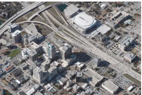
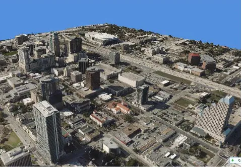
True 3D images can be used to produce 3D models, such as 3D city models. 3D city models made by such true 3D images look realistic, accurate, complete, and consistent and very importantly they are measurable, not just for look. Making 3D city models with true 3D images is a unique approach and there are several advantages associated with this approach. First, this approach bypasses the time consuming and labor intensive cut-and-paste processes that most people use today to make 3D building models. This approach saves a lot of time and labor work. Second, the 3D city model made by this approach look realistic, complete, and consistent comparing with the fake looking, incomplete, and inconsistent 3D city model by today’s common practices. Third, the 3D city models made by this approach are measurable comparing with many 3D city models that are only for look. Figure 3 and 4 are examples of 3D city model made by this approach for Orlando, Florida.
2.2.4 Other Potential Applications
Because of the realistic and measurable characteristics of the 3D city models or just 3D models produced by the true 3D images, basically the 3D models can used at any places where accurate, realistic, consistent, and complete 3D information is needed. For examples, they can used for:
Public safety and security City planning and construction Telecommunications
Military exercise simulations Pilot training simulations
Environmental protection and monitoring Surveying and mapping
Others
Figure 3. A perspective view of 3D Orlando
Figure 4. Another perspective view of 3D Orlando.
3. FINAL REMARKS
Comparing with today’s widely used 2D orthophotos, true 3D images can provide an additional third dimension Z to users while preserving all the features of 2D orthophotos, therefore true 3D images should become a standard layer in any Geographic Information System in the future.
The era of realistic and measurable 3D models is coming. During the last several years, people started to try to produce realistic 3D city models. In this effort, 3D models produced by using the true 3D images are playing a leading role. The 3D models produced by using the true 3D images represent the ultimate standard of a 3D model. The ultimate standard for a 3D model is that such a 3D model should present all the objects in the scene it covers realistically, accurately, completely, consistently, and measurable. International Archives of the Photogrammetry, Remote Sensing and Spatial Information Sciences, Volume XXXIX-B4, 2012
XXII ISPRS Congress, 25 August – 01 September 2012, Melbourne, Australia