Open Geospatial Consortium
Date: 2012-01-25 Reference number of this OpenGIS® Project Document: OGC 09-153r1 Version:1.0 Category: OpenGIS® Primer Editor: Peter Baumann
OGC® Web Coverage Service 2.0 Primer:
Core and Extensions Overview
Copyright © 2012 Open Geospatial Consortium
To obtain additional rights of use, visit http://www.opengeospatial.org/legal/.
Warning
This document is not an OGC Standard. This document provides informative information about a specific standard, best practices, and implementation guidance.
Document type: OpenGIS®Primer Document subtype:
ii Copyright © 2012 Open Geospatial Consortium
Contents
Page
1 Scope ... 1
2 Compliance ... 1
3 Normative references ... 1
4 Terms and definitions ... 1
5 Conventions ... 1
5.1 UML notation ... 1
5.2 Namespace prefix conventions ... 1
6 WCS Package Overview ... 2
6.1 Core and extensions ... 2
6.2 Application Profiles ... 2
7 Possible extensions ... 3
7.1.1 Introduction ... 3
7.1.2 Identification ... 4
7.2 Data model extensions ... 4
7.2.1 Purpose ... 4
7.2.2 List of existing and planned extensions ... 4
7.2.2.1 Nil values ... 4
7.2.2.2 Uncertainty ... 5
7.3 Coverage encoding extensions ... 5
7.3.1 Purpose ... 5
7.3.2 List of extensions ... 5
7.4 Service model extensions ... 5
7.4.1 List of extensions ... 5
7.4.1.1 Scaling and interpolation ... 5
7.4.1.2 CRS, EPSG-based ... 5
7.4.1.3 CRS, general ... 6
7.4.1.4 Transactional service (WCS-T) ... 6
7.4.1.5 Web Coverage Processing Service (WCPS) ... 6
7.5 Protocol extensions ... 6
7.5.1 Purpose ... 6
OGC 09-153r1
7.5.2.1 HTTP GET/KVP ... 6
7.5.2.2 HTTP POST/XML ... 6
7.5.2.3 SOAP ... 7
7.5.2.4 REST ... 7
7.6 Usability extensions ... 7
7.6.1 Purpose ... 7
7.6.2 List of extensions ... 7
7.6.2.1 Multi-lingual support ... 7
8 Possible application profiles ... 7
iv Copyright © 2012 Open Geospatial Consortium
i.
Preface
This document provides an overview on the OGC Web Coverage Service (WCS) 2.0 suite by describing WCS core and extensions.
Intended target audience are developers intending to implement WCS servers and/or clients. This document aims at providing an overview and giving useful hints and best practices beyond the pure standards texts. It is a “living document” which will evolve to reflect new developments and best practices.
As such, the contents of this document is informative and not of normative nature.
ii.
Terms and definitions
This document uses the specification terms defined in Subclause 5.3 of [OGC 06-121r9], which is based on the ISO/IEC Directives, Part 2, Rules for the structure and drafting of International Standards. In particular, the word “shall” (not “must”) is the verb form used to indicate a requirement to be strictly followed to conform to this standard.
iii.
Submitting organizations
The following organizations have submitted this Implementation Specification to the Open Geospatial Consortium, Inc.:
Jacobs University Bremen
National Center for Atmospheric Research (NCAR)
Oracle USA
PCI Geomatics Inc.
ERDAS, Inc.
EOX IT Services GmbH
Spot Image
BAE Systems - C3I Systems
Natural Environment Research Council (NERC)
OGC 09-153r1
Copyright © 2012 Open Geospatial Consortium v
iv.
Document Contributor Contact Points
v.
Revision history
Date Release Author Paragraph modified Description
2009-10-30 0.0.1 PB All Created
vi.
Changes to the OpenGIS
®Abstract Specification
The OpenGIS® Abstract Specification does not require any changes to accommodate the technical contents of this document.
vii.
Future Work
This document needs to be updated whenever a new extension is added to WCS. It may need an update if and when significant functionality changes are made to existing WCS
components.
Name Organization
vi Copyright © 2012 Open Geospatial Consortium
Foreword
Some of the elements of this document may be the subject of patent rights. Open Geospatial Consortium Inc. shall not be held responsible for identifying any such patent rights.
Attention is drawn to the possibility that some of the elements of this document may be the subject of patent rights. The Open Geospatial Consortium shall not be held responsible for identifying any or all such patent rights.
OGC 09-153r1
Copyright © 2012 Open Geospatial Consortium vii
Introduction
The OGC Web Coverage Service (WCS) supports electronic retrieval of geospatial data as "coverages" – that is, digital geospatial information representing space/time-varying phenomena.
WCS 2.0 consists of a set of normative specifications, collectively referred to as “the WCS suite”. These specifications encompass (see normative references):
GML 3.2 Application Schema for Coverages WCS 2.0 Core
A set of extensions to the WCS Core.
Copyright © 2012 Open Geospatial Consortium 1
Core and Extensions Overview
1 Scope
The scope of the informative content in this document is the OGC Web Coverage Service 2.0 (WCS) and later versions suite of standards.
2 Compliance
This document does not contain any normative statements. Therefore, there are no
requirements or compliance statements defined. In the case where differences exist between the standard and this document, the normative text in the standard texts shall prevail.
3 Normative references
The following normative documents contain provisions that, through reference in this text, constitute provisions of this specification. For dated references, subsequent amendments to, or revisions of, any of these publications do not apply. For undated references, the latest edition of the normative document referred to applies.
OGC 06-121r9, OGC®Web Service Common Interface Standard, version 2.0
OGC 09-110r3, OGC®Web Coverage Service 2.0 Interface Standard Core, version 2.0 OGC 09-146r1, OGC®GML 3.2.1 Application Schema for Coverages, version 1.0
4 Terms and definitions
Definitions from GML Application Schema [OGC 146r1] and WCS Core [OGC 09-110r3] apply.
5 Conventions
5.1 UML notation
All the diagrams that appear in this specification are presented using the Unified Modeling Language (UML) static structure diagram, as described in Subclause 5.2 of OGC Web Service Common [OGC 06-121r9].
5.2 Namespace prefix conventions
OGC 09-153r1
2
Copyright © 2012 Open Geospatial Consortium
6 WCS Package Overview
6.1 Core and extensions
The WCS model defined in this document and the WCS “core” standard provide the ability to define many extension packages that add specific functionality to the WCS data and/or service model.
The Section 7 contains existing, planned, and possible WCS extensions. The section is grouped based on what appears reasonable as of the publication of this document. However, this structuring is by no means normative and shall not be used to draw any conclusions on the functionality a particular extension provides.
WCS Core and each extension specify, as normative requirements, which prerequisite specifications they require. Frequently, options are possible in some specific group of extensions; for example, every WCS implementation must support at least one protocol extension.
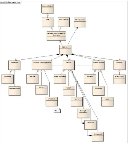
This constitutes a dependency graph as shown in Figure 1.
6.2 Application Profiles
An Application Profile (AP) defines WCS functionality for some particular purpose. To this end, two mechanisms are available:
The AP can make a choice among the extensions it declares mandatory (note that the core has to be included in any case).
Note that there may be cross dependencies between some extensions that have to be respected. For example, the core requires at least one protocol extension, and the CRS extension requires the scaling & interpolation extension.
For example, a SCADA (Supervisory Control and Data Acquisition) AP might allow only 1-D time coverages and GML encoding, whereas an Earth Observation AP might allow only x/y and x/y/t coverages and GeoTIFF, but not include a GML encoding. A metocean AP might set out for n_D coverages delivered, e.g., in netCDF.
Additional restrictions can be imposed on core and extensions.
In the above example, the Earth Observation AP might allow only x/y and x/y/t coverages and GeoTIFF, but no GML encoding. Schematron1 offers a convenient
way for doing so and iscompatible with the overall WCS standard style. Further, the EO AP might further restrict and define the concrete usage of the metaData
element of AbstractCoverage.
Consequently, a conformance test for an AP will in turn inspect the GML Application Schema for WCS, the WCS Core, any extension listed, and finally the specific requirements of the AP on hand.
Copyright © 2012 Open Geospatial Consortium 3
Figure 1 —WCS specification hierarchy graphical overview
7 Possible extensions
7.1.1 Introduction
OGC 09-153r1
4
Copyright © 2012 Open Geospatial Consortium
comprehensive; some extensions listed here may never be written, and others not listed may be developed.
Following the presentation in Section 6, extensions are grouped into
Data model extensions: they extend or refine coverage-related data structures; Format encoding extensions: they describe encodings applicable for the transfer of
coverages (not for the request encodings!);
Service model extensions: they add further service capabilities;
Protocol binding extensions: they describe client/server communication protocols and the encoding of parameters shipped using these protocols.
Usability extensions: they add means to better use the services.
7.1.2 Identification
Every WCS extension is identified by a unique URI that, by convention, is specified in the first formal requirement of an extension specification.
All extensions implemented by a WCS server must be reported by that server; this is done by listing the identifying URN of each extension in the Profile list of its GetCapabilities
response.
WCS extension identifiers follow this schema:
http://www.opengis.net/def/conf-class/OGC-WCS/0/ extension/EXTENSION-CLASS/EXTENSION
where
EXTENSION-CLASS identifies the extension class (such as data model);
EXTENSION identifies the particular extension (actually, a conformance class thereof)
7.2 Data model extensions
7.2.1 Purpose
This category of extensions focuses on adding information contents to the coverage model, be it for coverages when offered by a WCS server or for coverages generated for delivery or consumption by a WCS.
7.2.2 List of existing and planned extensions
7.2.2.1 Nil values
Specific values can be designated to represent “nil” (“null”) values. This extension is
Copyright © 2012 Open Geospatial Consortium 5
7.2.2.2 Uncertainty
Coverage range values can be annotated with a degree of uncertainty. This extension is under discussion, however, the WCS WG felt that an OGC-wide overarching concept should be resolved first rather, than establishing an ad-hoc solution.
7.3 Coverage encoding extensions
7.3.1 Purpose
Coverages can be delivered by GetCoverage requests (or uploaded, via WCS-T Transaction requests) in different data formats.
In addition and independently from any data format, coverages can be delivered as either pure GML documents, or as a format-encoded data file only, or as a combination where GML is used to represent the metadata and the data file holds the range values (“pixels”, “voxels”). This will be described in a separate format extension.
Every WCS, be it client or server, shall support at least one encoding format. This can be a format defined in an extension or the GML coverage representation defined in [OGC 09-110r3] and [OGC 09-146r1].
7.3.2 List of possible extensions
This open-ended list is likely to encompass GML, NetCDF, GeoTIFF, and many more. Note that not all formats are suitable to transport all kinds of coverages; limitations can be given by, for example, the dimensions supported (TIFF cannot hold 4-D coverages) or the cell type (BMP cannot hold hyperspectral imagery).
7.4 Service model extensions
This category of extensions describes additional functionality that may be added to a WCS.
7.4.1 List of extensions
7.4.1.1 Scaling and interpolation
With this extension, GetCoverage allows for scaling of coverage results; different interpolation techniques can be selected for the resampling performed during a scaling operation.
7.4.1.2 CRS, EPSG-based
This will allow coverages to be requested in different CRSs; to this end, the server needs to be able to perform a CRS transform of the coverage prior to its delivery. CRSs supported are those defined by EPSG.
OGC 09-153r1
6
Copyright © 2012 Open Geospatial Consortium
NOTE This will be a normative requirement stated in the WCS 2.0 CRS Extension (which is not yet existing, but in planning at the time of this writing).
7.4.1.3 CRS, general
As in the previous Subclause, this will allow coverages to be requested in different CRSs; to this end, the server needs to be able to perform a CRS transform of the coverage prior to its delivery. CRSs supported are all types defined by OGC; including nested ad-hoc defined CRSs.
This extension requires extension “CRS, EPSG-based”.
NOTE This will be a normative requirement stated in the WCS 2.0 CRS Extension (which is not yet existing, but in planning at the time of this writing).
7.4.1.4 Transactional service (WCS-T)
WCS-T [OGC 07-068r4] specifies the ability to insert, update, and delete coverages offered by a WCS server.
7.4.1.5 Web Coverage Processing Service (WCPS)
WCPS defines a query language that specifies how to combine and process coverages for navigation, extraction (download), aggregation, and ad-hoc analysis. The abstract language is defined in [OGC 08-068r1], the WCS protocol embedding in [OGC 08-059r3]. The WCS embedding of WCPS requires implementation of [OGC 08-068r1].
7.5 Protocol extensions
7.5.1 Purpose
This category of extensions describes client / server communication protocols (including request parameter encodings) which a WCS implementation may offer and use. Every WCS, be it client or server, shall support at least one protocol extension.
NOTE This does not include result coverage encodings as delivered by GetCoverage requests.
7.5.2 List of extensions
7.5.2.1 HTTP GET/KVP
Requests are sent as HTTP GET parameters. Coverages are encoded in some data format (as specified by a format encoding extension), other response parameters are encoded in XML.
7.5.2.2 HTTP POST/XML
Copyright © 2012 Open Geospatial Consortium 7
7.5.2.3 SOAP
Requests and responses are communicated via SOAP using XML. Coverages are transferred using some data format (as specified by a format encoding extension).
7.5.2.4 REST
Requests are sent using the RESTful paradigm. Coverages are encoded in some data format (as specified by a format encoding extension).
7.6 Usability extensions
7.6.1 Purpose
This set of extensions focuses on usability of the service overall, rather than on bespoke data or service functionality.
7.6.2 List of extensions
7.6.2.1 Multi-lingual support
Text messages can be delivered in various languages by a service.
8 Possible application profiles
A WCS Application Profile (AP) bundles core plus a set of bespoke extensions into a standard suitable for handling coverages as they occur in some specific application domain. Currently the following APs are under consideration:
Time series
Coverages are one-dimensional and have only a time dimension. Often this dimension is named “t” or “time”.
Earth observation
Coverages are two-dimensional and have only geographically horizontal dimensions. Often these dimensions are named “x” and “y” or “latitude and “longitude”.
Sometimes coverages have a time dimension in addition, yielding 3-D time series data cubes.
Metocean data
OGC 09-153r1
8
Copyright © 2012 Open Geospatial Consortium
9 Conventions and best practices
The WCS 2.0 suite remains rather general to be adjustable to many different application domains. To ensure a maximum of interoperability, the following non-normative conventions are recommended.
Best Practice 1 The optional ServiceIdentification section in a Capabilities
response should be present.