SAC-D AQUARIUS A SATELLITE FOR OCEAN, CLIMATE AND ENVIRONMENT.
ONE YEAR OF DATA.
S. Torrusio a, G. Lagerloef b, M. Rabollia, D. LeVinec
a
CONAE, National Commission on Space Activities, Avda. Paseo Colón 751, Buenos Aires (1063), Argentina –
(storrusio, mrabolli)@conae.gov.ar
b
ESR, Earth and Space Research, 2101 Fourth Ave., Suite 1310, Seattle, US – [email protected]
cNASA Headquarters, 300 E Street SW, Washington DC,US - [email protected]
Commission VIII, WG VIII/9
KEYWORDS: SAC-D Aquarius, ocean salinity, microwave radiometers, optical sensors, international mission, observatory.
ABSTRACT:
The SAC-D/Aquarius satellite was launched in June 10, 2011. It´s a joint mission between Argentina (through CONAE) and US (NASA). This satellite is a true Observatory with a suite of sensors for Earth Observation, its weight is 1400 kg, sun-synchronous orbit at 657 km (6 pm ascendant node), revisit of seven days. Other space agencies have contributed with instruments and support (facilities and ground segment), as CNES, CSI, ASI and AEB/INPE. The primary objective is to monitor global variations in ocean surface salinity (SSS) in order to improve the knowledge about ocean circulation, water cycle and climate. The SSS is performed with Aquarius instrument (NASA). Other oceanic and atmospheric parameters are measured with a MWR, from CONAE, in K and Ka band, as wind speed, rain rate, sea ice, water vapour and liquid water in clouds. The thermal camera (NIRST) estimates sea surface temperature and detect high temperature events (fires and volcanic eruptions). The High Sensitivity Camera (HSC) generates night images (very useful for fishery activity monitoring in the sea, studying of electrical storms, polar auroras and urban application). The DCS (Data Collection System, from CONAE) can receive meteorological and environmental data from ground platforms and distribute among users. The TDP (Technological Demonstration Package, from CONAE) measures different parameters of satellite position and velocity. Other two important instruments are ROSA (from Italy) and CARMEN 1 (from France). The first is an atmospheric sounder, it allows elaborating atmospheric profiles of temperature, pressure and humidity, and the second has detectors for studies of space debris and the effects of radiation on electronic devices.
This work provides a review of the first year of data, including the status of calibration and validation, other finding and at the same time we want to present the progress in the active educational and outreach program including the information of SAC-D Aquarius Mission.
___________________________________
*
Corresponding author: Sandra Torrusio
International Archives of the Photogrammetry, Remote Sensing and Spatial Information Sciences, Volume XXXIX-B8, 2012 XXII ISPRS Congress, 25 August – 01 September 2012, Melbourne, Australia
1. INTRODUCTION
The SAC-D/Aquarius satellite was launched in June 10, 2011 from Vanderberg, California. It´s a joint mission between Argentina (through CONAE (National Commission on Space Activities) and US (NASA). This satellite is a true Observatory with a suite of sensors for Earth Observation, its weight is 1400 kg, sun-synchronous orbit at 657 km (6 pm ascendant node), revisit of seven days. Other space agencies have contributed with instruments and support (facilities and ground segment), as CNES (National Centre of Space Studies, from France), CSI (Canadian Space Agency, from Canada), ASI (Italian Space Agency, from Italy) and AEB (through INPE belonging to Brazilian Space Agency, from Brazil). The Ground Segment of CONAE (in Córdoba) has the control of the satellite from the Ground Station in Córdoba, Argentina.
The primary objective of the mission is to monitor global variations in ocean surface salinity (SSS) in order to improve the knowledge about ocean circulation, water cycle and climate. The SSS is performed with Aquarius instrument (from NASA, it´s an integration of radiometer and scatterometer in L band). Other oceanic and atmospheric parameters are measured with a Microwave Radiometer (MWR, from CONAE, in K and Ka band) as wind speed, rain rate, sea ice, water vapour and liquid water in clouds. The thermal camera (NIRST) estimates sea surface temperature and detect high temperature events (fires and volcanic eruptions). The High Sensitivity Camera (HSC) generates night images (very useful for fishery activity monitoring in the sea, studying of electrical storms, polar auroras and urban application). The DCS (Data Collection System, from CONAE) can receive meteorological and environmental data from ground platforms and distribute among users. The TDP (Technological Demonstration Package, from CONAE) measures different parameters of satellite position and velocity.
Other two important instruments are ROSA (from Italy) and CARMEN 1 (from France). The first is an atmospheric sounder, it allows elaborating atmospheric profiles of temperature, pressure and humidity, and the second has detectors for studies of space debris and the effects of radiation on electronic devices. At the time of this writing, the Aquarius sensor has collected ocean salinity data since late August 2011, and initial unvalidated data have been released for evaluation.
The instrument generates a salinity global map every seven days and is designed to achieve 0.2 psu accuracy over monthly averages on 150km spatial scale. The data show very robust signatures of the basin and sub-basin scale salinity patterns. These measurements can be improved with the use of MWR data because the rain, the wind and the sea ice are errors source for the salinity estimation, so the synergy between both instruments with a coincident footprint allow these improvements. We are working now on this point providing MWR data (level L1A y L1B) and generating the first products (L2). The cal/val of these data is also in progress.
The NIRST camera (bands in: 4, 11 and 12 microns) was developed in collaboration with Canada, and it is the first time that microbolometers technology are in the space. Now we are working on calibration data and preparation of the first products. The HSC camera, ROSA and CARMEN 1 instruments are the second in its type, because the first are on board the SAC-C satellite (launched in 2000 and currently in orbit).
The mentioned parameters are being used for the International Science Team in different issues (emergencies, soil moisture, health, hydrology, ice, atmosphere, etc.) and they are or will be available from the web site of NASA and CONAE.
This Mission is in the framework of National Space Plan of Argentina, which social benefit areas related to this project are: productive activities as fishery and agricultural, health and disaster (floods, droughts, fire, volcanic eruptions); ocean and
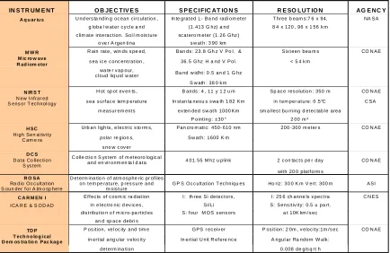
IN S T R UM E NT O B JE C TIV E S S P E CI F IC AT IO N S R E SO LUT IO N AG E NC Y
Table 1: Main characteristics and applications of each instrument on board SAC-D/ AQUARIUS.
International Archives of the Photogrammetry, Remote Sensing and Spatial Information Sciences, Volume XXXIX-B8, 2012 XXII ISPRS Congress, 25 August – 01 September 2012, Melbourne, Australia
climate. This work provides a review of the first year of data, including the status of calibration and validation, other finding and at the same time we want to present the progress in the active educational and outreach program including the information of SAC-D Aquarius Mission.
2. GENERAL DESCRIPTIONS AND APPLICATIONS OF THE SENSORS
The Table 1 summarizes the general characteristics of each instrument on board SAC-D Aquarius satellite, and their main applications related to ocean, climate and environment
.
3. FIRST RESULTS
The following figures (1,2,3,4,5,6) show the first science data obtained from SAC-D Aquarius Observatory. These are some examples, now we are working on the calibration of each instruments and the validation of the data in order to improve the quality of data and products for end users.
Many academic and scientific teams around the world are developing new algorithms and products. Some of these data can be downloaded from NASA and CONAE web site.
4. CONCLUSIONS
These results demonstrate the performance of the satellite and its sensors. At present we are working on the calibration of the instruments and validation of the data.
The International Science Team of this mission are using and applying the data around the world. More than 40 groups from US, Argentina, Italy, Japan, Brasil, Chile are part of the international team, and the exchange among them is very rich. This is the beginning. In the case of Argentine Projects (15), they are supported for the Ministry of Science, Technology and Productive Innovation.
The activities in education and public outreach are other important point in the Mission, a lot of material was prepared for the web site, for hardcopies and digital format.
5. ACKNOWLEDGEMENTS
The authors thank to the NASA, CONAE and all the institutions who are participated in this big project.
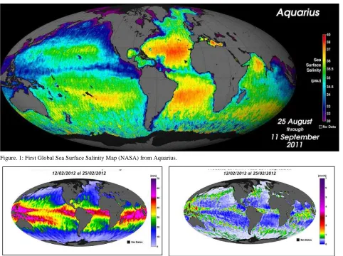
Figure. 1: First Global Sea Surface Salinity Map (NASA) from Aquarius.
Figure 2: Global Water Vapour Map from MWR
.
Figure 3: Global Rain Rate Map from MWR.
International Archives of the Photogrammetry, Remote Sensing and Spatial Information Sciences, Volume XXXIX-B8, 2012 XXII ISPRS Congress, 25 August – 01 September 2012, Melbourne, Australia
Revised May 2012
Figure. 4: Global Wind Speed Map from MWR.
Figure 5: Sea Ice Concentration in Antartica from MWR.
i d
d
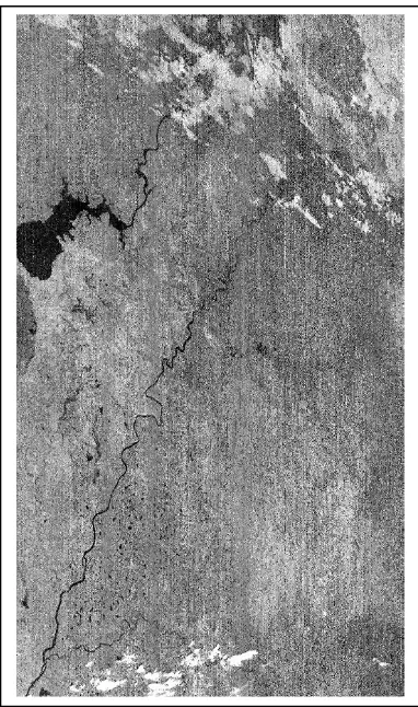
Figure 6: Non calibrated image of Mesopotamia Sector (Argentina), from NIRST .(11 μm).
Figure 7: Fire detected by HSC in Arauco Gulf (Chile).
International Archives of the Photogrammetry, Remote Sensing and Spatial Information Sciences, Volume XXXIX-B8, 2012 XXII ISPRS Congress, 25 August – 01 September 2012, Melbourne, Australia