Urban and Regional Planning
This is the fourth edition of the classic text for students of urban and regional planning. It gives a historical overview of the developments and changes in the theory and prac-tice of planning in the United Kingdom, throughout the entire twentieth century.
This revised edition follows the successful format of previous editions:
● It introduces the establishment of planning as part of the public health reforms of the late nineteenth century and goes on to look at the insights of the great figures who influenced the early planning movement, leading up to the creation of the postwar planning machine.
● National and regional planning, and planning for cities and city regions, in the UK from 1945 to 2000, is then considered. Specific reference is made to the most impor-tant British developments in recent times, including the Single Regeneration Budget, English Partnerships, the devolution of Scotland, Wales and Northern Ireland, the establishment of the Mayor of London and the dominant urban sustainability paradigm.
● ‘Planning in Western Europe since 1945’ now incorporates new material on EU-wide issues, as well as updated country-specific sections.
● ‘Planning in the United States since 1945’ now discusses the continuing trends of urban dispersal and social polarization, as well as initiatives in land-use planning and transportation policies.
● Finally, the book looks at the nature of the planning process at the end of the twen-tieth century, reflecting briefly on shifts in planning paradigms since the 1960s and going on to discuss the main issues of the 1990s, including sustainability and social exclusion and looking forward to the twenty-first century.
Urban and Regional
Planning
Fourth edition
Peter Hall
London and New York
•T ay
lor &
FrancisG
rou p
•
R
O
First edition published in 1975 by David and Charles (Holdings) Ltd Second edition published in 1985 by Unwin Hyman
Third edition published in 1992 by Routledge Reprinted 1994, 1996, 1999, 2000 (twice) Fourth edition published in 2002 by Routledge 11 New Fetter Lane, London EC4P 4EE
Simultaneously published in the USA and Canada by Routledge
29 West 35th Street, New York, NY 10001
Routledge is an imprint of the Taylor & Francis Group
© 1975, 1985, 1992, 2002 Peter Hall
All rights reserved. No part of this book may be reprinted or reproduced or utilized in any form or by any electronic, mechanical, or other means, now known or hereafter invented, including photocopying and recording, or in any information storage or retrieval system, without permission in writing from the publishers.
British Library Cataloguing in Publication Data
A catalogue record for this book is available from the British Library Library of Congress Cataloging-in-Publication Data
Hall, Peter Geoffrey.
Urban and regional planning / Peter Hall.–4th ed. p. cm.
Includes bibliographical references and index.
1. City planning. 2. Regional planning. 3. City planning–Great Britain. 4. Regional planning–Great Britain. I. Title.
HT166 G7 H34 2002
307.1’2–dc21 2002069951
ISBN 0–415–21776–8 (hbk) ISBN 0–415–21777–6 (pbk)
This edition published in the Taylor and Francis e-Library, 2005.
“To purchase your own copy of this or any of Taylor & Francis or Routledge’s collection of thousands of eBooks please go to www.eBookstore.tandf.co.uk.”
Contents
Preface vii
Acknowledgements ix
Chapter 1 Planning, planners and plans 1
Chapter 2 The origins: urban growth from 1800 to 1940 11
Chapter 3 The seers: pioneer thinkers in urban planning, from 1880 to 1945 27
Chapter 4 Creation of the postwar British planning machine, from 1940 to 1952 55
Chapter 5 National/regional planning from 1945 to 2000 79
Chapter 6 Planning for cities and city regions from 1945 to 2000 99
Chapter 7 Planning in Western Europe since 1945 145
Chapter 8 Planning in the United States since 1945 189
Chapter 9 The planning process 211
Preface
It is important to stress what this book is and what it is not. It is not a textbook of plan-ning; there are excellent examples of those now available, including especially Barry Cullingworth’s classic Town and Country Planning in Britain (13th edition, with Vincent Nadin; Routledge, 2001). Rather, it is an introduction to planning, written both for the beginning student and for the general reader. I hope that it will be found useful by students of applied geography and of town and country planning; by university and college students concerned to fit modern planning into its historical context; and by a wider audience which may want to know how planning has evolved.
Two points must be made about the treatment. First, it is deliberately historical; it traces the evolution of urban and regional problems, and of planning philosophies, tech-niques and legislation, from the Industrial Revolution to the present day. Second, it is necessarily written from a British standpoint for a British readership (though I hope that readers from other Commonwealth countries will find it relevant). Throughout most of the book the exclusive emphasis is on the British experience, though the survey of early planning thought in Chapter 2 is international, and Chapters 7 and 8 deliberately range out to compare the experience of other advanced industrial countries. Even in those chapters the comparison deliberately excludes the developing world; doubtless, another useful book is to be written there, but there is no space in this book to do the subject justice.
The book is a by-product of thirty years of lectures on introductory applied geogra-phy and planning at the London School of Economics, the University of Reading, the University of California at Berkeley, and latterly at University College London. I am grateful to successive waves of students who endured these courses and who unfailingly, by their reactions, indicated the places where material was boring or unintelligible. More particularly, I remain indebted to two academic colleagues and friends, both sadly now deceased: to Brian McLoughlin for his characteristically generous and thoughtful comments on a first draft; and to Marion Clawson for bringing his immense experience to bear on the account in Chapter 8. I must add the usual disclaimer: that I am solely responsible for errors and omissions.
To two devoted helpers – my secretaries, Monika Wheeler and Rosa Husain, who typed two successive versions of the manuscript meticulously despite unnaturally heavy departmental burdens, and my cartographer, Kathleen King – I offer my best thanks. (I must also reflect, in this fourth edition, that the personal computer is relieving them and their successors from further such burdens.)
Acknowledgements
The author and publishers would like to thank the following for granting permission to reproduce the following illustrations as listed:
California Department of Transportation, Senior photographer Lynn G. Harrison, Plate 8.3; CORUS, Plate 5.1; The Cultural Section of the Embassy of Sweden, Plate 7.3; DATAR, Figures 7.2, 7.3; European Communities, 1995–2002, from the Eurostat website, Figure 7.1d, 7.14; Faber & Faber Ltd, Plate 3.4; Federal Office for Building and Regional Planning (BBR), Bonn, Figure 7.8; Ford Motor Company, Plate 5.2; The Head of Engineering Services, Manchester City Council, Figure 3.4; The Head of Planning Policy, Stevenage Borough Council, Figure 4.2, Plate 4.3; HMSO, Figures 6.6, 6.16; IAURIF, Figure 7.7b; KLM Aerocarto – Arnhem, Holland, Plate 7.4; The Ministry of Housing, Physical Planning and Environment, The Netherlands, Figure 7.13b; Regional Plan Association, Plates 8.1, 8.2, Figure 8.2; Simmons Aerofilms Ltd, Plates 2.2, 2.3, 2.4, 3.2, 4.1, 4.2, 5.3, 6.1, 6.2, 6.4, 6.5; John Wiley and Sons Ltd, Figure 6.15.
Planning, planners and plans
Planning, the subject matter of this book, is an extremely ambiguous and difficult word to define. Planners of all kinds think that they know what it means; it refers to the work they do. The difficulty is that they do all sorts of different things, and so they mean different things by the word; planning seems to be all things to all people. We need to start by defining what exactly we are discussing.
The reference in the dictionary gives one clue to the confusion. Whether you go to the Oxford English Dictionaryor the American Webster’s, there you find that the noun ‘plan’ and the verb ‘to plan’ have several distinct meanings. In particular, the noun can either mean ‘a physical representation of something’ – as for instance a drawing or a map; or it can mean ‘a method for doing something’; or ‘an orderly arrangement of parts of an objective’. The first meaning, in particular, is quite different from the others: when we talk about a street ‘plan’ of London or New York, we mean something quite different from when we talk about our ‘plan’ to visit London or New York next year. But there is one definition that combines the others and blurs the distinction, as when we talk about a ‘plan’ for a new building. This is simultaneously a physical design of that building as it is intended to be, and a guide to realizing our intention to build it. And it is here that the real ambiguity arises.
The verb ‘to plan’, and the nouns ‘planning’ and ‘planner’ that are derived from it, have in fact only the second, general group of meanings: they do not refer to the art of drawing up a physical plan or design on paper. They can mean either ‘to arrange the parts of’, or ‘to realize the achievement of’, or, more vaguely, ‘to intend’. The most common mean-ing of ‘plannmean-ing’ involves both the first two of these elements: plannmean-ing is concerned with deliberately achieving some objective, and it proceeds by assembling actions into some orderly sequence. One dictionary definition, in fact, refers to what planning does; the other, to how planning does it.
The trouble arises because although people realize that planning has this more general meaning, they tend to remember the idea of the plan as a physical representation or design. Thus they imagine that planning must include the preparation of such a design. Now it is true that many types of planning might require a physical design, or might benefit from having one: planning often is used in the production of physical objects, such as cars or aeroplanes or buildings or whole towns, and in these cases a blueprint of the desired product will certainly be needed. But many other types of planning, though they will almost certainly require the production of many symbols on pieces of paper, in the form of words or diagrams, may never involve the production of a single exact physical representation of the entity which is being produced.
bureaucracy (as happens, by repute, in France), but merely that advance planning is necessary if students are to find classrooms and libraries and teachers when they arrive at a certain age and seek a certain sort of education. We talk about planning the economy to minimize the swings of boom and slump, and reduce the misery of unemployment; we hear about a housing plan and a social services plan. Industry now plans on a colossal scale: the production of a new model of a car or a personal computer has to be worked out long in advance of its appearance in the shops. And all this is true whatever the nature of the economic system. Whether labelled free enterprise or social democratic or socialist, no society on earth today provides goods and services for its people, or schools and colleges for its children, without planning. One might regret it and wish for a simpler age when perhaps things happened without forethought; but if that age ever existed, it has gone for ever.
The reason is the fact of life everybody knows: that modern society is immeasurably more complex, technically and socially, than previous societies. Centuries ago, when education involved the simple repetition of a few well-understood rules which were taught to all, and when books were non-existent, the setting up of a school did not involve much elaborate plant or the training of specialized teachers. The stages of production were simpler: wood was cut in the forest, people wrought it locally into tools, the tools were used by their neighbours, all without much forethought. But today, without elaborate planning, the complex fabric of our material civilization would begin to crack up: supplies of foodstuffs would disappear, essential water and power supplies would fail, epidemics would rapidly break out. We see these things happening all too readily after natural or human disasters like earthquakes or wars or major strikes by railway or power workers. Though some of us may decide to opt out of technological civilization for a few years or for good, the prospect does not seem likely to appeal to the great mass of humankind even in the affluent world. Those in the less affluent world are in much less doubt that they want the security and dignity that planning can bring.
The point is that the sorts of planning which we have been discussing in these last two paragraphs either may not require physical plans at all, in the sense of scale blue-prints of physical objects, or may require them only occasionally or incidentally. They are more likely to consist, for the most part, of written statements accompanied by tables of figures, or mathematical formulae, or diagrams, or all these things. The emphasis throughout is on tracing an orderly sequence of events which will achieve a predeter-mined goal.
the lifetime of the programme, ways will need to be found of monitoring progress very closely to take account of unexpected failures or divergences from the plan or changes in the situation. In the whole of this complex sequence the only scale models may be the designs of the new schools or of the TV system and a few other details – a small part of the whole, and one which comes at a late stage in the process, when the broad outlines of the programme are determined.
To summarize, then: planning as a general activity is the making of an orderly sequence of action that will lead to the achievement of a stated goal or goals. Its main techniques will be written statements, supplemented as appropriate by statistical projec-tions, mathematical representaprojec-tions, quantified evaluations and diagrams illustrating relationships between different parts of the plan. It may, but need not necessarily, include exact physical blueprints of objects.
Application to urban and regional planning
The difficulty now comes when we try to apply this description to the particular sort of planning that is the subject matter of this book: urban and regional planning (or, as it is often still called, town and country planning). In many advanced industrial countries, such as Britain, the United States, Germany or Japan, the phrase ‘urban planning’ or ‘town planning’ is strictly a tautology: since a great majority of the population are classed in the statistics as urban and live in places defined as urban, ‘town planning’ seems simply to mean any sort of planning whatsoever. In fact, as is well known, ‘urban’ planning conventionally means something more limited and precise: it refers to plan-ning with a spatial, or geographical, component, in which the general objective is to provide for a spatial structure of activities (or of land uses) which in some way is better than the pattern that would exist without planning. Such planning is also known as ‘phys-ical’ planning; ‘spatial’ planning is perhaps a more neutral and more precise term.
If such planning centrally has a spatial component, then clearly it makes sense only if it culminates in a spatial representation. Whether this is a very precise and detailed map or the most general diagram, it is to some degree a ‘plan’ in the first, more precise meaning of the term. In other words, it seems that urban planning (or regional planning) is a special case of general planning, which does include the plan-making, or represen-tational, component.
Broadly, in practice this does prove to be the case. It is simply impossible to think of this type of planning without some spatial representation – without a map, in other words. And whatever the precise organizational sequence of such planning, in practice it does tend to proceed from very general (and rather diagrammatic) maps to very precise ones, or blueprints. For the final output of such a process is the act of physical devel-opment (or, in some cases, the decision not to develop, but to leave the land as it is). And physical development, in the form of buildings, will require an exact design.
A great deal of discussion and controversy in recent years tends to have obscured this fact. In most countries spatial or urban planning as practised for many years – both before the Second World War and after it – was very minute and detailed: the output tended to consist of very precise large-scale maps showing the exact disposition of all land uses and activities and proposed developments. During the 1960s such detailed plans were much attacked: planning, it was argued, needed to concentrate much more on the broad principles rather than on details; it should stress the process, or time sequence, by which the goal was to be reached, rather than present the desired end state in detail; it should start from a highly generalized and diagrammatic picture of the spatial distributions at any point of time, only filling in the details as they needed
to be filled in, bit by bit. This, as we shall see later, is the essential difference in Britain between the system of local town and country planning introduced by the historic Town and Country Planning Act of 1947, and the system which replaced it under the Town and Country Planning Act of 1968.
The central point, though, is that this type of planning is still essentially spatial – whatever the scale and whatever the sequence. It is concerned with the spatial impact of many different kinds of problem, and with the spatial coordination of many different policies. Economic planners, for instance, are concerned with the broad progress of the economy, usually at national and sometimes at international level: they look at the evolving structure of the economy, in terms of industries and occupations, at the combi-nation of the factors of production which brings forth the flow of goods and services, at the income thus generated and its reconversion into factors of production, and at problems of exchange. Regional economic planners will look at the same things, but always from the point of view of their particular spatial impact: they consider the effect of the variable, geographical space and distance, on these phenomena. Similarly, social planners will be concerned with the needs of the individual and the group; they will be concerned with the changing social structure of the population, with occupa-tional mobility and its effect on lifestyles and housing patterns, with household and family structure in relation to factors like age and occupation and educational back-ground, with household income and its variation, with social and psychological factors which lead to individual or family breakdown. Social planners in the urban planning office share the same interests and concerns, but see them always with the spatial compo-nent: they are concerned, for instance, with the effect of occupational mobility on the inner city – as against the new suburb – on changing household structure as it affects the housing market near the centre of the city, on household income in relation to items like travel cost for the low-income family whose available employment may be migrating to the suburbs.
The relationship between urban and regional planning and the various types of special-ized planning, in these examples, is interestingly like the relationship of geography, as an academic subject, to other, related social sciences. For geography also has a number of different faces, each of which stresses the spatial relationship in one of these related sciences: economic geography analyses the effect of geographic space and distance on the mechanisms of production, consumption and exchange; social geography similarly examines the spatial impact upon patterns of social relationship; political geography looks at the effect of location upon political actions. One can argue from this that spatial planning, or urban and regional planning, is essentially human geography in these various aspects, harnessed or applied to the positive task of action to achieve a specific objective.
to this distinction, ‘planning method’ would be what is common to the education of all kinds of planners – whether educational, industrial, military or any other; geography and its related social sciences would constitute the peculiar subject matter of that partic-ular division of planning called urban and regional.
‘Planning’ as an activity
What then would this core of planning education – the study of planning process – com-prise? This is a basic question, and one which ought to have been the subject of intense debate in schools of planning. But curiously, for a long time it was avoided – the rea-son being, apparently, that planning education was seen as education in making physi-cal plans, not education in planning method. The first people to raise the question seriously were not teachers of physical planning, but teachers of industrial or corporate planning in the American business schools. There, down to about 1945, education in management was usually based on a rather narrow spectrum of skills in applied engi-neering and accounting; the aim was to obtain maximum efficiency in plant operation, both in an engineering sense and in an accounting sense, and little attention was given to the problems of decision-taking in complex situations. But during the 1950s, partly as the result of the work of such fundamental thinkers as Chester Barnard, Peter Drucker and Herbert Simon, management education was transformed. First, it developed into a science of decision-making, which borrowed freely from concepts in philosophy and pol-itics; and second, it harnessed the thinking of a number of social sciences, such as eco-nomics, sociology and psychology. It was this new tradition in corporate planning which began, after about 1960, to affect the direction and content of education for physical planning.
By this time, however, management education had further evolved. With the devel-opment of computerization in management and planning of all kinds, there was increasing interest in the development of sophisticated control systems which would automatically control machinery. Such systems, of course, were only a development of earlier experiments in automation, which can be dated right back to the origins of the Industrial Revolution; but progress in this field took a big leap forward with the rapid development of more complex computers during the 1950s. Yet even before this, a remarkable original thinker, Norbert Wiener of Harvard, had anticipated the develop-ment and much more. In a book published in 1950, The Human Use of Human Beings, he had suggested that automation would liberate the human race from the necessity to do mundane tasks. But further, he proposed that the study of automatic control systems was only part of a much larger science of cybernetics,* which he defined in the title of a book published in 1948 as the science of ‘control and communication in the animal and the machine’. According to Wiener, animals and especially human beings have long possessed extremely complex communication and control mechanisms – the sort of thing the computer was then replicating. Human societies, Wiener suggested, could be regarded as another manifestation of this need for communication and control.
Thus a new science was born. Rapidly developing in the late 1950s and 1960s, it had a profound influence on research and education in management, and particularly in plan-ning. For if human arrangements could be regarded as complex interrelating systems, they could be paralleled by similar systems of control in the computer, which could then be used to monitor developments and apply appropriate adjustments.
Planning, planners and plans • 5
The best analogy, much quoted at that time, was manned space flight. In an expedi-tion to the moon, most of the adjustments to the spacecraft are made not by the astro-nauts but by an extraordinarily complex computer control system on earth at Houston, Texas. Similarly, it is argued, the development of cities and regions could be controlled by a computer which received information about the course of development in a partic-ular area, related to the objectives which had been laid down by the planners for the development during the next few years and thus produced an appropriate series of adjust-ments to put the city or the region ‘on course’ again.
In practice this insight has been very useful for the way we think about physical or spatial planning. Information systems are now used very widely in the planning process. And, as we shall see in later chapters of this book, it has profoundly affected the way planners think about their job and the way they produce plans. In essence it has led to a swing from the old idea of planning as production of blueprints for the future desired state of the area, and towards the new idea of planning as a continuous series of controls over the development of the area, aided by devices which seek to model or simulate the process of development so that this control can be applied. This in turn has led to a com-plete change in the sequence of planners’ work. Formerly, at any time from about 1920 until 1960, the classic sequence taught to all planning students was survey–analysis–plan. (The notion of survey before plan had first been worked out, and taught, by a remark-able British pioneer in planning, Patrick Geddes; his work is discussed in more detail in Chapter 3.) The terms were self-explanatory. First the planner made a survey, in which s/he collected all the relevant information about the development of the city or region. Then s/he analysed the data, seeking to project them as far as possible into the future to discover how the area was changing and developing. And third, s/he planned: that is, s/he made a plan which took into account the facts and interpretations revealed in the survey and analysis, and which sought to harness and control the trends according to principles of sound planning. After a few years – the British Planning Act of 1947 laid down that the period should be every five years – the process should be repeated: the survey should be carried out again to check for new facts and developments, the analy-sis should be reworked to see how far the projections needed modifying, and the plan should be updated accordingly.
Objectives in planning – simple and complex
In practice, as I have said above, this is a great improvement. It means that the whole planning process is more clearly articulated, more logical and more explicit. It is obvi-ously better that planners should start with a fairly exhaustive discussion about what they are seeking to achieve and that they should go on having this discussion during the whole planning process. It is better, too, that different alternatives for the future should be developed, so that they can be openly discussed and evaluated. And the emphasis on specific evaluation, using certain fixed criteria, is an advance. Planning is now much more flexible, working with much greater information. And it is more rational – at least potentially so.
Nevertheless, the alternative system has created many new problems and pitfalls of its own. The development of computerization does not make planning easier, in the sense that it somehow becomes more automatic. There may be many automatic aids to smooth out tedious processes, such as detailed calculations; but they do not diminish the area of human responsibility – the responsibility to take decisions. And the basic difficulty is that it is harder, and finally just less feasible, to apply cybernation to most urban planning problems than it is to apply it to the job of getting human beings on the moon.
At first sight this may seem absurd: nothing could be more complex than space travel. But this is to mix up levels of complexity. Space travel (or, indeed, commercial avia-tion) presents many technical problems, but there are two features that make it basically simple. First, the objective is clearly understood. Second, the processes involved are nearly all physical: they are subject to laws of physics, which are much better under-stood, and which appear to be more regular in their application, than laws of human behaviour. (There are human beings involved, of course, but in practice they are reduced to little more than biological units for most of the voyage.) The kind of planning that most resembles space travel is transportation planning, and it is significant that this was where computerized systems planning had its earliest and most successful applications. Elsewhere, it has proved harder.
That is because it is inherently more complex. First, the basic objective is not well understood; there is clearly more than one objective, and perhaps dozens (economic growth, fair distribution of income, social cohesion and stability, reduction of psycho-logical stress, a beautiful environment – the list seems endless). These objectives may not be readily compatible, and may indeed be contradictory. Second, most of the processes which need controlling are human processes, which are less well understood and work with much less certainty than laws in the physical sciences. Anyone who has studied any of the social sciences such as economics, sociology, psychology or human geography is familiar with this fact. Just as in these sciences we have to work with laws of statistical tendency rather than with laws which are constantly reliable in producing experimental results, so it will be in much of spatial or physical planning.
nor multi-objective. (Or, to be more precise, even if the engineer thinks s/he has more than one objective, these are all engineering objectives within the same basic dimen-sion.) This engineer, or colleagues like the highway engineer or telephone engineer, are doubtless all working with plans which are spatial representations of their territory. But none of them will be trying (for instance) to balance the advantages of preserving a long-established inner-city society against the advantages of building better housing on an estate some distance away, or the problem of reconciling higher car ownership with the preservation of public transport for those who have no access to cars and the preser-vation of a decent urban environment, or the merits of segregating factory zones versus the merit of having local factories nearer to people’s homes – all of these, and many more, being considered as part of the same planning process, and having finally each to be considered vis-à-visall the others. This task of reconciliation is the essence of the job of the urban and regional planner; this is why, compared with most other sorts of job regarded as planning, it is so difficult.
It is difficult in two ways. First, the amount of necessary information and specialized expertise is so much greater than in most other planning activities: it covers almost the whole of human experience. The ideal urban and regional planner would have to be a good economist, sociologist, geographer and social psychologist in his or her own right, as well as having several other necessary physical-scientific skills, such as a good under-standing of civil engineering and of cybernetics. To judge the quality of the informa-tion s/he was receiving, s/he would need to be a sophisticated (and even slightly sceptical) statistician. And s/he would need to be a highly competent systems analyst in order to develop the relationships with the computer control system with which s/he related. All of which, of course, constitutes an impossible specification – and a daunting task for the educationalist.
But second, and even more problematically, there is the need to frame and then weigh up different objectives. Consider a very typical (and very topical) type of planning controversy, repeated almost daily: the line of a new urban motorway. Some critics say that it would be quite unnecessary if public transport were adequate; some that the line should be shifted. The fact is that car ownership is rising, and this seems outside the planner’s control; it is set by the political or social framework within which s/he acts. The projections (which may not be entirely reliable) suggest that the traffic will over-whelm the present road network, giving an environment to many thousands of people which, by current standards, is judged intolerable. The quality of public transport is declining, but the available evidence shows that better quality would not have much result in tempting people back from their cars and reducing the case for the motorway. One possible line for the motorway goes through a slum district due for early demoli-tion and rebuilding; some sociologists say that the community should be rehoused in situ, others argue that many of the people would lead happier lives in a new town. Another line goes through open space which contains playing fields as well as the nesting grounds of several species of birds; local sports clubs and nature conservationists are united in opposing this line. The costs to the public purse are known in the two cases, but the benefits are dependent on the valuation of travel time for the likely motorway users, on which two groups of economists are hotly disputing. And the costs, or disben-efits, for different groups of the public affected by the building of the motorway are almost incalculable.
is no clear resolution, and the most the planner can do is to try to reach a decision within a clear and explicit framework – which, one hopes, the new style of planning helps him or her to do.
The example has been given simply to illustrate the unique quality, and the unique difficulty, of the sort of planning that is the subject matter of this book. To sum up: urban and regional planning is spatial or physical: it uses the general methods of planning to produce a physical design. Because of the increasing influence of these general meth-ods, it is oriented towards process rather than towards the production of one-shot (or end-state) plans. Its subject matter is really that part of geography which is concerned with urban and regional systems; but the planning itself is a type of management for very complex systems. And further, it is necessarily multidimensional and multi-objective in its scope; this is what distinguishes it from the work of many other professionals whose work can fairly be described as planning with a spatial component.
Structure of this book
The remainder of this book falls into five parts. Chapters 2 and 3 outline the early history of urban development in Britain, with special references to the changes brought about by the Industrial Revolution, and the contributions of notable early thinkers and writers on urban planning during the period 1880–1945. Chapter 4 takes the British story through the 1930s and 1940s, describing the new challenge of regional imbalance which appeared in the Great Depression of 1929–32, and the subsequent creation of the postwar planning machine following publication of the Barlow Report of 1940. Chapters 5 and 6 analyse the postwar history, and attempt to pass judgement on the performance of the planning system, first at broad regional level in respect of economic planning, then at the scale of the town and the city region in respect of urban planning. Chapters 7 and 8 attempt a comparative look at planning experience in other developed industrial coun-tries, Chapter 7 for Western Europe and Chapter 8 for the United States. Lastly, Chapter 9 provides an outline of the sequence of urban and regional plan-making, with an intro-duction to some of the more important techniques involved at various stages of this process; it is deliberately written to provide a bridge to the more advanced textbooks of planning, which deal with these processes in more detail. But this book, as I have stressed in the Preface, must end there; it does not try to compete with those textbooks, but to provide the necessary historical framework of introduction to them.
Further reading
Andreas Faludi, Planning Theory(Oxford: Pergamon, 1973), is a good introduction to these questions. John Friedmann, Planning in the Public Domain (Princeton, NJ: Princeton University Press, 1988), is the most comprehensive treatment. Other good accounts are from Patsy Healey, Land Use Planning and the Mediation of Urban Change:
The British Planning System in Practice(Cambridge: Cambridge University Press, 1988)
and Patsy Healy, Collaborative Planning: Shaping Places in Fragmented Societies
(Basingstoke: Macmillan, 1997).
The origins: urban growth
from 1800 to 1940
Modern urban and regional planning has arisen in response to specific social and economic problems, which in turn were triggered off by the Industrial Revolution at the end of the eighteenth century. It is important to notice that these problems did not all come at once, in the same form; they changed in character, and in their relative impor-tance, so that the questions uppermost in the minds of city-dwellers in the 1930s were by no means the same as those experienced by their great-grandfathers in the 1840s. As problems were identified, solutions were proposed for them; but because of the inertia of people’s minds, and still more the inertia of social and political processes, these solu-tions – especially the more radical ones – might not be put into action until decades afterwards, when the problem itself had changed in character and perhaps also in impor-tance. That is a most important common theme which runs through this and the next two chapters.
Planning before the Industrial Revolution
There were important cities before the Industrial Revolution: ancient Rome had an estimated population of 1,000,000 by the year AD100; Elizabethan London numbered
about 200,000 people. Correspondingly, these cities had problems of economic and social organization: Rome had to be supplied with water brought over considerable distances by aqueduct (the word itself is Roman in origin), and the city developed immense problems of traffic congestion – which unfortunately have been inherited by the modern city two thousand years later. London by the fourteenth century had to draw on coalfields by the River Tyne, 270 miles (430 km) away, for fuel, and on distant countries for more specialized provisions, such as dyestuffs or spices; by the seven-teenth century it, too, was drawing water from 35 miles (56 km) away by aqueduct. (The New River, which runs through north London, is part of it.) These problems in turn brought forth a host of regulations for the better ordering of the city, sometimes dealing with strangely modern problems: Rome banned chariot movement at night to deal with the first recorded case of urban noise pollution; in London in the fourteenth century a man was hanged for burning ‘sea coal’ – a somewhat draconian penalty for medieval air pollution.
Winchelsea on the Sussex coast, and small towns in north Wales like Flint, Conwy and Caernarfon, were all fortified towns created by Edward I in the late thirteenth century, and were deliberately modelled on the Bastide towns established by the French kings as part of their conquest of Provence a few years earlier.
The greatest flowering of formal town planning before the Industrial Revolution, though, came in what is known in continental Europe as the Baroque era: the seven-teenth and eighseven-teenth centuries. There it produced such masterpieces of large-scale architectural design as the reconstruction of Rome during the late sixteenth and early seventeenth centuries; or the great compositions of the Tuileries gardens and the Champs-Élysées, in Paris; or the palace of Versailles and its bordering planned town; or the completely planned town of Karlsruhe, in Germany; or the seventeenth-century quarters of Nancy, in the province of Lorraine in eastern France; as well as many other smaller, but fine, examples. These were nearly all expressions of absolute regal or paper power, and some commentators have claimed to see in them the expression of a new style of warfare; instead of the medieval walled town, cities must now be planned along broad formal avenues along which mobile armies could deploy themselves. Britain, after Cromwellian times, had no such absolute monarchy; here the aristocracy and the new merchant class dominated the growth of cities and determined their form. The result was a different but equally distinctive form of town planning: the development of formal residential quarters consisting of dignified houses built in terraces or rows, generally on a strongly geometrical street plan which was modified by charming squares with gardens. The original development of many of the quarters of London’s West End, now sadly much damaged by later reconstruction – areas like St James’s, Mayfair, Marylebone and Bloomsbury – still provides the best examples in Britain of this type of planning attached to an existing major city; Edinburgh’s New Town, facing the medieval city across the deep cut now occupied by the railway, is another. But perhaps the best example of eigh-teenth-century British town planning is the development of Bath, up to then a small medieval town, as the result of a new enthusiasm for spa cures among the aristocracy at that time.
All these examples, and many other imitations, have great interest for the student of architecture or the origins of planning. And similarly, the creation of the rural landscape of Europe – a process which involved much more conscious planning than most people, looking at the result casually, would imagine – is important for the planner, under-standing how previous generations adjusted to the opportunities and the limitations the region presented. But the subject deserves much fuller treatment than it can receive here; and it is excellently written up in the book The Making of the English Landscape by W.G. Hoskins. Our main concern now is a subject that has little relation with the past: the unprecedented impact of modern industrialism on urban development and upon consequent urban planning problems.
The impact of industrialism
of small industrial hamlets across an area that was fundamentally still rural. In some industries this tradition survived even longer: D.H. Lawrence’s early novels describe it in the Nottinghamshire coalfields as late as 1900.
But it was coal that changed the situation. As soon as it became a principal raw mate-rial of industry – replacing water power in textiles after 1780, for instance – it tended to concentrate industry where supplies could be made available: on the coalfields them-selves, and then adjacent to bulk transport. Britain, because it industrialized earlier than any other country, experienced special constraints on its industrial location pattern: the early machinery consumed great quantities of coal because it was inefficient, and the coal was very expensive to transport because there were no railways, only canals. After about 1830 (the first steam-driven railway, the Stockton and Darlington, came in 1825) both these conditions changed, and industry was freer to locate. But by then its pattern was fixed (Figure 2.1).
This fact alone created a new phenomenon: the new industrial town, developed almost from nothing – or perhaps from a small and obscure village origin – within a few years, on the coalfields of Lancashire and Yorkshire and Durham and Staffordshire. Simultaneously, some towns – those which were neither port towns nor on coalfields – stagnated industrially. But many older-established medieval towns – because they were near enough to coalfields, or because they were on navigable water, or because they became railway junctions soon after the railways arrived – were also able to become major centres of the new factory industry: Leicester, Nottingham and Bristol are good examples. Port towns, indeed, were just as important as pure industrial towns in the whole process of industrialization, because they effected the critical exchange of raw materials and finished products on which the whole system depended; thus cities like Liverpool, Hull, Glasgow and, above all, London were among the fastest-growing places from 1780 onwards.
Some of the resulting growth patterns are extraordinary – even by the standards of the twentieth century, which has become used to mushrooming growth in the cities of the developing world. The most spectacular cases were, of course, some of the new industrial towns which developed almost from nothing. Rochdale in Lancashire, for instance, numbered about 15,000 in 1801, 44,000 in 1851 and 83,000 in 1901; West Hartlepool in County Durham grew from 4,000 in 1851 to 63,000 by 1901. But though their percentage rate of growth was necessarily more modest, many bigger and older-established centres managed to maintain an amazing rate of growth throughout most of the century. London doubled from approximately l million to about 2 million between 1801 and 1851; doubled again to 4 million by 1881; and then added another 21⁄
2million
to reach 61⁄
2million in 1911.
The parallel with the cities of the developing world is, in several ways, only too exact. The people who flooded into the burgeoning nineteenth-century industrial and port cities of Britain were overwhelmingly coming from the countryside. They tended to be drawn from the poorer section of the rural population: those who had least to lose and most to gain by coming to the city. Many of them had found it increasingly difficult to get work after the enclosure movement which, approved and planned by Parliament, transformed so much of midland and southern England during the eighteenth century. Some of them – like the Irish who flooded into Liverpool and Manchester and Glasgow after the failure of the potato harvest in 1845–6 – were truly destitute. They had little or no knowledge of the technical skills needed by the new industry, or of the social and technical neces-sities of urban life. And though the industry of the towns provided economic opportu-nities in plenty for an unskilled labour force, the social arrangements in the towns were quite incapable of meeting their needs for shelter, for elementary public services like water and waste disposal, or for health treatment.
This last point is critical: these towns had only the most elementary arrangements, or none, for providing water, or clearing refuse or sewage, or for treating mass epidemics. Many of the towns, having sprung up so rapidly from villages, had virtually no arrange-ments at all. Even in the larger towns they had been very elementary; and they tended to be quite overwhelmed by the influx. In a stagnant or slowly growing city, or in a relatively small town, the consequences might not have been so dire: wells might not have become polluted so easily by sewage; new dwellings could be constructed quite easily outside the existing town limits without overcrowding. But in the rapidly growing towns these solutions were not open. Because there was no system of public transport to speak of, the new population, like the old, had to be within walking distance of work in the factories or warehouses. Within the limits thus set, population densities actually tended to rise during the first half of the nineteenth century; the census records for London or Manchester show this quite clearly.
The results could have been predicted. Limited water supplies were increasingly cont-aminated by sewage; there were quite inadequate arrangements for disposal of waste, and filthy matter of all kinds remained close to dense concentrations of people; water supplies were lacking or fitful, and personal hygiene was very poor; overcrowding grew steadily worse, in the form of both more dwellings per acre and more people per room; cellar dwellings became all too common in some cities, such as Manchester or Liverpool; medical treatment, and above all public health controls, were almost completely lacking. And, to make things worse, the greater mobility induced by trade meant that epidemics could move more rapidly across the world than ever before. This, plus polluted water supplies, was the basic cause of the terrible cholera epidemics that swept Britain in 1832, 1848 and 1866.
The results for public health became clear only after the establishment of an efficient government organization for charting the state of public health: the General Register Office, set up in 1837. William Farr, the first Registrar General and one of the founding fathers of the modern science of statistics, showed as early as 1841 that the expectation of life at birth – 41 years in England and Wales overall and 45 in salubrious Surrey – was only 26 years in Liverpool; two years later in Manchester, it was only 24. Much of this difference arose because of the shockingly high infant mortality rates in the northern industrial towns: 259 out of every 1,000 children born died within the first year of life in Liverpool in 1840–1, and in the early 1870s the average was still 219. (The corresponding figure for Liverpool in 1970 was 21 – an eloquent testimony to the improved quality of life.)
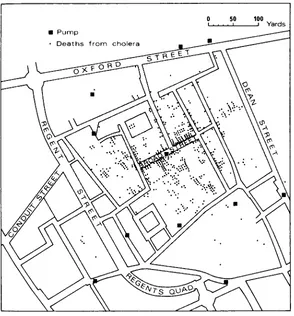
It was a situation which society could not tolerate for long. Even in the most cynical view, the more privileged members of society – the industrialists and merchants – were likely to suffer from it: less so than their workers, to be sure, but still the statistics showed that the risk was considerable. Yet the struggle for reform was a difficult one; it had to surmount at least three major hurdles. The first was the will to act; and this took some time to spread to a large section of the controlling interests who dominated Parliament and the local authorities. Until 1832, it must be remembered, Parliament was totally unrepresentative of the experience and the views of those in the industrial towns. The second was knowledge of how to act; and on many critical questions, such as the germ-borne causation of disease and its treatment, and above all the origin of cholera, medical experts were sadly ignored until after the turn of the century. (Cholera was first identified as a water-borne disease in 1854 by a London doctor, John Snow; in an early piece of spatial analysis (Figure 2.2) he proved that the outbreaks in a slum district of London were systematically associated with the water supply from a single pump. But it was not until some time after this that the mechanism was understood.) The third need was for effective administrative machinery, including finance, for instituting the
necessary controls and providing public services; and this, in an era of rampant
laissez-faire, was in many ways the hardest of all, involving as it did the reform of existing
and ineffectual local governments.
at their own expense; the Cross Acts, from 1875 onwards, allowed local authorities themselves to prepare improvement schemes for slum areas (Plate 2.1). The last of these Acts – the Public Health Act of 1875 – produced a long-overdue fundamental reform of local government in England and Wales, outside the boroughs: the country was divided into urban and rural sanitary districts, which would be supervised by a central government department already set up in 1871, the Local Government Board. The word ‘sanitary’ in their title amply indicates the original scope of these authorities; but soon they were incorporated in a comprehensive local government reform. Three Acts – the Municipal Corporations Act of 1882 and the Local Government Acts of 1888 and 1894 – gave new local government structures to the boroughs, the counties (plus new county boroughs or large towns) and county districts. This system survived almost unchanged until the major reform of English local government carried through by the Act of 1972. These local authorities, but above all the boroughs, increasingly began to adopt model by-laws for the construction of new housing from the 1870s onwards. By-law housing, as it came to be known, can readily be recognized in any large British city. It tends to occur in a wide ring around the slums of the earlier period (1830–70), most of which were swept away in the great assault on the slums between 1955 and 1970. Drably func-tional, it consists of uniform terraces or rows of two-storey housing in the local building material (brick in most parts of the country, stone on the upland borders in Lancashire and the West Riding). The streets have a uniform minimum width to guarantee a modicum of air and light; each house originally had a separate external lavatory, with access to a back alley running parallel to the street. (This was necessary for the emptying of earth closets; for even in the 1870s it was impossible to provide for water-borne clear-ance of waste from many of these houses. It was also thought desirable for clearclear-ance of solid refuse.) So originally these houses had neither inside lavatory nor inside bath – indeed, no fixed bath at all. They represented a housing problem in the 1960s and 1970s; but since they were built according to some minimal standards, most have been upgraded to reasonable modern standards without the need for demolition. And the areas The origins: 1800–1940 • 17
in which they were concentrated were at the same time often environmentally improved, enhancing their basic qualities of good neighbourliness and thus making them into rather good living environments for a new generation of owner-occupiers. But a generation later, at the turn of the century, some of these areas – especially in northern cities – were being abandoned, as owners found newer and more desirable housing elsewhere. Commonly, even with the more generous standards of street width which were required, by-law housing was built at net densities of about 50 houses to the acre (124/hectare). (The term ‘net density’, often used in this book, means density of housing or people on the actual housing area, including local streets; it does not include associ-ated open space, public buildings, or industry.) Given the large families of three or four children prevailing, this could mean densities of 250 people to the acre (620/hectare) or more. In London densities of over 400 to the acre (1,000/hectare) persisted in places as late as the Second World War. Today, with smaller households, these densities are a memory.
The phenomenon of urban spread
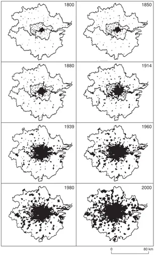
But by and large, the period after 1870 marks a significant change in the development of British cities – and, as far as can be seen from international studies by the economist Colin Clark, in other countries’ cities too. In fact, the trend is quite marked for London after the 1861 census. Up to that time, as we noted earlier, densities were actually rising within a radius of about 3 miles (4.8 km) from the centre of British cities – the radius within which people could walk to their work within about an hour, there being no effec-tive public or private transport of any kind for most of the population. If we look at a town like Preston (Plate 2.2), which had changed little in the hundred years or so between the time when most of the buildings were erected and the time of the photograph (about 1935), we should realize that most of the people living in these gardenless houses, without public parks, nevertheless could walk to open fields within about twenty minutes. (This was as true in 1935 as in 1835.) And since the cotton mills – then, the chief and almost the sole source of work for many – were scattered fairly evenly across the town, journeys to work on foot were quite extraordinarily short: an average mill hand could walk to and from work four times a day, coming home for a midday meal, in rather less time than the average modern commuter spends on his or her outward morning journey. Even the biggest European city, London, grew relatively little in area as it doubled in population from 1 to 2 million people between 1801 and 1851.
But then, between about 1870 and 1914, virtually all British cities rapidly acquired a cheap and efficient public transport system – first (in the 1870s and 1880s) in the form of horse trams and buses, then (at about the turn of the century) of electric trams, and lastly (just before the First World War) in the form of motor buses. In very large cities like London there were also commuter trains. The early railways had neglected the possi-bilities of suburban traffic, even in London, but most of them awoke to the possipossi-bilities after 1860; and one, the Great Eastern, serving north-east London, was compelled by Parliament to run cheap trains for workmen, allowing them to live in suburbs as distant as Edmonton and Leytonstone. London even had a steam-operated underground railway, the world’s first, by 1863; its first electric tube railway opened in 1890 and its first elec-trified suburban lines in 1905–9.
had not increased to much more than 3 miles (4.8 km), with higher densities in the inner areas. Then the city began to spread in all directions, but particularly to the south and north-east – as seen in the map for 1880 and, even more clearly, for 1914. This last represents the apogee of what can fairly be called the early public transport city. The steam trains gave fairly easy and rapid access to middle-class commuters (and, in east London, the working class too) at distances up to 15 miles (24 km) from the centre. But they accelerated and decelerated poorly; stops tended to be widely spaced; and feeder services, in the form of horse buses or trams, were poorly developed, or slow. The result is a typically tentacular form of growth, with development taking the form of blobs (or beads on a string, to change the metaphor) around each station.
Between the two world wars the whole process of suburban growth and decentraliza-tion began to speed up; in doing so it changed its form. The forces behind the suburban movement during those years were partly economic, partly social, partly technological. Economic forces in the world outside – world depression between 1929 and about 1934, a general depression in the prices of primary products – meant that both labour for construction and building materials were cheap. Social changes, too, were produced by economic development: more and more workers were becoming white-collar employees in offices or shops or other non-factory occupations, enjoying regular salaries which allowed them to borrow money on credit, and regarding themselves as members of an enlarging middle class. In large numbers, these people began to aspire to buy a house The origins: 1800–1940 • 19
1850 1800
1914 1880
1960 1939
2000 1980
80 km 0
of their own with the aid of a mortgage. Lastly, and perhaps most fundamentally, further developments in transport technology extended the effective commuting range: electric trains in London, motor buses elsewhere, allowed the effective area of the city to extend up to four or five times the previous limits.
Such growth was particularly well marked in London. In 1914 London had a popu-lation of about 61⁄
2million; by 1939, 81⁄2million. Yet in that period the capital’s
built-up area extended about three times. The underground railways before 1914 had barely extended beyond the existing developed area; but after 1918 they began to colonize new territory, extending quickly above ground on to previously undeveloped areas. The result was as predicted: a vast flood of speculative building, cheaply built for sale. Plate 2.3 shows the result around just one station: Edgware in Middlesex, some 12 miles (19 km) from central London, in 1926 – two years after the line was opened – and 1948 – a quarter of a century later.
The precise impact of this sort of development upon the urban structure can be well seen by comparing the maps of London in 1914 and 1939 respectively in Figure 2.3. London in 1914, as we have already noted, had the characteristically tentacular shape associated with the early public transport city – the city of the steam train and the horse bus. By 1939 it had assumed a completely different shape: growth was much more even in any direction, producing a roughly circular city with a radius about 12 to 15 miles (19 to 24 km) from the centre. The basic reason for this was a change in the technology of transportation. First, electric trains were more efficient carriers than the steam trains had been: accelerating and decelerating rapidly, they could serve more frequently spaced stations. Second, and even more importantly, the motor bus allowed a fairly rapid urban transport service to penetrate in any direction from these stations, along existing roads, without the need for elaborate capital investment on the part of the operator; it there-fore served as a highly efficient feeder service. These changes altered the pattern of accessibility within the urban area. The isochrones (lines of equal accessibility to the centre, in terms of time) were in 1914 very irregular; they fingered out a long way along the railway lines. By 1939 they had become more even and circular (or concentric) in form; and the development of the urban area followed accordingly. This form we can call typical of the later public transport city; it was not at all a creation of the private car, since in London by 1939 only about one family in ten owned one.
The same process was repeated around the provincial cities too, though on a smaller scale, and dependent on the tram or bus rather than the train. In some of the bigger cities – Manchester, Liverpool and Leeds – the local authorities themselves contributed to the process. They rehoused many thousands of slum-dwellers and other people in need of public housing by developing new estates of single-family homes – generally at distances from 4 to 7 miles (7–11 km) from the city centre, in the case of the biggest cities, and connected to it by rapid, frequent and cheap public transport. Like the private housing, this was cheaply built (and, unlike most of the private housing, it was aided by central government subsidy as the result of a 1919 Housing Act). It was also of a standard never before reached in public housing: equipped with basic facilities like bathrooms, and with generous private garden space around. These authorities built fairly faithfully according to the recommendations of an influential official report, the Tudor Walters Report, which had been published at the end of the First World War in 1918; it had recommended development of single-family homes at about 12 per net residential acre (30/hectare), or about one-quarter the density of the old by-law housing.
This also was the density of much of the private housing developed around London and other big cities; many private estates were built at even lower densities: 10 or 8 or even 6 houses to the acre (15–24/hectare). For the general feeling was that more spacious housing standards were a healthy reaction to the cramped terraces of the
Plate 2.3Edgware, north-west London: (a) 1926; (b) 1948, showing the impact of the extension of the underground railway (station in centre of pictures) on suburban development. Typical are the uniform rows of semi-detached housing, built at about 12 dwellings to the acre (30/hectare), with generous gardens. Better transportation allowed the city to spread.
(a)
nineteenth-century industrial town; the bus and the electric train had liberated the manual workers in their rented council houses and the white-collar workers in their mortgaged semi-detached houses alike. And because the improved transportation made so much land potentially developable, the price of land was low. Indeed, it is clear from later research that land prices and house prices, which are always so closely related, reached a low point in relation to income in the 1930s that has never been equalled before or since (Figure 2.4). It was actually easier for the average clerical or skilled manual worker to buy a house in the 1930s than it is in the more affluent Britain of seventy years later.
The reaction against sprawl
A minority of thinking people, however, were alarmed at the result. They included both town planners, who by then existed as a profession – the Town Planning Institute had been incorporated in 1914 – and rural conservationists. They were concerned at the fact that the development was uncontrolled by any sort of effective planning. Though Acts of Parliament had provided for local authorities to make town planning schemes for their areas – in 1909, in 1925 and then, most decisively, in 1932 – basically these Acts gave them no power to stop development altogether where such development was not in the public interest; developers could build almost wherever they liked, provided they followed the general lines of the local town planning scheme. And this, the planners and conservationists argued, had two bad effects.
First, development was using up rural land – the great majority of it agricultural land – at an unprecedented rate. By the mid-1930s, as subsequent research showed, some 60,000 acres (24,000 hectares) each year (out of 37 million acres (15 million hectares) in all) were being taken from agriculture in England and Wales for all forms of urban development. Because the development was completely uncontrolled, it was no respecter of the quality of agricultural land: the suburban spread of London, for instance, took much of the finest market gardening land in all England, on the gravel terrace-lands west of the capital (ironically, later on, Heathrow Airport took much of the rest) (Plate 2.4). The result, critics argued, was a major loss of home food production – a loss Britain could ill afford in times of war. And in the late 1930s, with war threatening, this seemed an important argument.
Second, the critics argued that the effect on townspeople was equally bad. Homes were being decentralized at greater and greater distances from the city centre, but jobs were not being decentralized nearly as rapidly. In London and in some of the bigger
Figure 2.4 A house-agent’s advertisement of the early 1930s. At this time house prices, aided by cheap labour and materials, were probably cheaper in relation to white-collar salaries than ever before or since. Commuting on the new electric lines round London was easy. There was a striking contrast with the poverty in the depressed industrial areas of the north.
increasingly insufferable burden on their inhabitants. And as new arterial roads were built to relieve traffic congestion on the old radial arteries out of the city, so these in turn were lined by ribbon development of new housing, compromising their function and reducing their efficiency. Ribbon development was partially controlled by an Act of 1935, but the real answer to the problem – motorways for through traffic, with limited access, of the kind already being opened in Italy and Germany – was not introduced to Britain until the Special Roads Act of 1949.
Thus a small, but powerful and vocal, movement built up to limit urban growth through positive planning. Essentially, it represented a working coalition between people interested in town planning – some, but not all of them, professional planners – and rural preservationists, who had been instrumental in organizing the Council for the Protection of Rural England (CPRE) in 1925. One strong figure spanned both camps and united them: Patrick Abercrombie, Professor of Planning in the University of London and founder of the CPRE. Though they were persuasive, they might not have been so effective if they had not been joined by a third group: the representatives of the depressed industrial areas of northern England, south Wales and central Scotland. We shall see in Chapter 4 how this happened. But meanwhile, we need to retrace our steps in time, to look at some of the most important ideas circulating among urban planners, and others interested in the subject, at this time.
Further reading
A standard textbook of modern economic and social history will provide indispensable background. Good examples include: E.J. Hobsbawm, The Pelican Economic History of
Britain, vol. 3: Industry and Empire(Harmondsworth: Penguin, 1970); and P. Mathias,
The First Industrial Nation: An Economic History of Britain 1700–1914 (London:
Methuen, 1969; paperback edition available). Roy Porter, London: A Social History
(London: Hamish Hamilton, 1994), and Michael Hebbert, London: More by Accident
than Design (Chichester: Wiley, 1998), contain excellent expositions of London’s
inter-war development.
These texts should be supplemented by W. Smith, A Historical Introduction to the
Economic Geography of Great Britain (London: Bell, 1968), which emphasizes the
geo-graphical impact of economic change, and then by W.G. Hoskins, The Making of the
English Landscape (Sevenoaks: Hodder & Stoughton, 1988), which discusses the impact
on the landscape.
On the earlier history of town planning, see W. Ashworth, The Genesis of Modern
British Town Planning (London: Routledge & Kegan Paul, 1954), and Leonardo
Benevolo, The Origins of Modern Town Planning (London: Routledge & Kegan Paul, 1967). These should be supplemented by Colin and Rose Bell, City Fathers
(Harmondsworth: Penguin, 1972), which gives an indispensable picture of early town planning experiments; and by Gordon E. Cherry, Cities and Plans: The Shaping of Urban
Britain in the Nineteenth and Twentieth Centuries (London: Edward Arnold, 1988).
On the interwar development, useful sources are S.E. Rasmussen, London the
Unique City (London: Cape, 1937), A.A. Jackson, Semi-detached London: Suburban
Developments Life and Transport, 1900–39, 2nd edition (Didcot: Wild Swan
Publications, 1991), and M. Swenarton, Homes Fit for Heroes (London: Heinemann, 1981). Peter Hall, Cities of Tomorrow (Oxford: Blackwell, 1988) is a comprehensive history of planning in this period.
The seers: pioneer thinkers
in urban planning, from
1880 to 1945
The whole of Chapter 2 has concentrated on the evolution of what can be called, broadly, the urban problem in Britain from the Industrial Revolution of the late eighteenth century to the outbreak of the Second World War. We have looked at the facts of urban devel-opment and at the attempts – often faltering and not very effective ones – on the part of central and local administration to deal with some of the resulting problems. This was the world of practical men grappling with practical matters. But no less important, during this time, were the writings and the influence of thinkers about the urban problem. Often their writings and their lectures reached only a tiny minority of sympathetic people. To practical men of the time, much of what they asserted would seem utopian, even cranky. Yet in sum, and in retrospect, the influence of all of them has been liter-ally incalculable; furthermore, it still continues.
This delay in the recognition and acceptance of their ideas is very important. Some of these ideas were more or less fully developed by the end of the nineteenth century, and a large part were known to the interested public by the end of the First World War. Yet with the exception of some small-scale experiments up to 1939, nearly all the influence on practical policy and design has come since 1945. One obvious peril in this is that no matter how topical and how appropriate these thinkers were in analysing the problems of their own age, their remedies might be at least partially outdated by the time they came to be taken seriously. We shall need to judge for ourselves how serious this has been.
It is useful to divide the thinkers into two groups: the Anglo-American group and the continental European group. The basis of the distinction here is more than one of conve-nience. Basically, the background of the two groups of thinkers has been quite different. We have already seen in Chapter 2 that in England and Wales (Scotland in this respect has been rather more like the European continent), cities began to spread out after about 1860: first the middle class and then (especially with the growth of public housing after the First World War) the working class began to move out of the congested inner rings of cities into single-family homes with individual gardens, built at densities of 10 or 12 houses to the acre (25–30/hectare). Exactly the same process occurred, from about the same time, in most American cities, though in some cases the process was delayed by the great wave of arrivals of national groups (such as Italians, Greeks, Russians, Poles, and Jews from Russia and Poland) between 1880 and 1910; they crowded together in ethnic ghettos in the inner areas of cities like New York, Boston and Chicago, and took some time to join the general outward movement. Nevertheless, by the 1920s and 1930s there was a rapid growth of single-family housing around all American cities, served by public transport and then, increasingly, by the private car. This was a tradition which, by and large, writers and thinkers in both Britain and the United States accepted as the starting point.