COMMUNITY-BASED PLANNING AND DESIGN COMPUTATION:
TOWARDS SUSTAINABLE URBAN SPATIAL DEVELOPMENT
Bauni Hamid
Department of Architecture, Faculty of Engineering University of North Sumatra, Medan
Abstract. This paper discusses potential of implementing computation in planning and design process as an integrated part of an urban development program. The main issue of computation, which is explored more detailed here is about its role in facilitating communication among various participants involved within urban development setting. Possibility of involving local people is more opened especially by utilizing the power of computation in visualizing whole project through multiple representations. Digital model has been empowered by interactivity and comprehensiveness of related information in text format. All format of information should be bundled within an integrated information system, which is developed based on GIS. Sustainability as keyword for the success of this system can be achieved through integrating its operation, system development and updating mechanism with academic works through collaboration with local university.
Keyword: community, computation, collaborative design, information system, GIS, urban development, sustainable
1. Introduction
Complicated problems around urban development issues are progressively diverging side by side with the more parties that characterize them. Certainly those issues need comprehensive and knowledge-based solution in order to balance its negative impacts. One of the most important problems that need to be anticipated is that of socialization of urban development program. This usually brings the issue about people’s resistance against program implementation. It might be understood since this party who will have direct implication of the physical development. Ironically, they almost never involved with the project implementation plan. This fact is usually happened on the project belonging to revitalization program, which means it develops on a settled neighborhood. Furthermore we could see clearly impacts of ineffective program along with its disorder operation and maintenance. Administrative
mechanism and information system are some of basic problems and significant constraints in improving the situation at once. Local government seems to be lost of control in managing the urban physical development. We need a real and practical solution rather than ideal concepts, which tend to be slogan but still abstract in implementation. In anticipating this issue the idea of community computing should be considered as alternative to bridge the existing information gap.
2. Information Strategy for Community
One significant aspect that characterizes a city is its rapid development. On the other hand local government usually failed to anticipate the dynamic of urban development. Its progressive movement is faster than what has been projected on early phases, and sometimes it has deviated from the anticipated planning. The deviation itself might be happened because of some aspects (Beauregard, 1996; Klosterman, 1996):
a.
The plan cannot reflect the most up to date situation, as its referred data is incomplete. Consequently government should arrange plan accurately in order to have a successful implication.b.
There is usually found weaknesses in controlling the implementation of urban development program, since local government hasn’t had adequate expertise to conduct an ideal controlling process. Supplying experts is not a simple task. Local government should have collaboration with local universities to handle this aspect. Following this step an independent institution should be made to run the urban development controlling process.c.
Rapid changes on the society itself should be realized as unavoidable facts. Consequently a plan should be continuously revised to anticipate the changes. In this case the rule of computer has been considered as main technological alternatives that may facilitate whole process in anticipating continuous changes.By using computer we can compile data, as it might be needed. And it can be collected from any sources including from community. People will have more opportunities to participate in data input process or even to utilize it.
Computer has given more expectation to create balance between development program and dynamics of people as urban community. Urban spatial planning and design is a sustainable process generated by various involved parties, various interests and a mechanism of negotiation, which is existed as result of the process. Hence computation of planning and design has a big potential to utilize the complicated problems that has characterized an urban development issues (Gross et al., 1997).
By using computer we may evaluate data and process it to be information. The information will be of use for any kind of purposes such as for local government, which needs it as basis for decision-making process. The information may be disseminated through any kind of electronic media, and specifically for digital information the Internet is very resourceful. These steps may also take any other kind of strategy such as using special column on local newspaper, which specifically publishes discussion on urban development issues. In a more sophisticated manner computer has also capability to perform simulation or prediction digitally. Changes occurred on an urban element for instance, may be tested or evaluated regarding its implication on whole urban system (Muhammadi, 2001).
Apart from its abundant positive implication, further implementation of computer as means for communication and information should be criticized. This is to consider local situation in Indonesia as a developing country. Even accessibility for conventional media of communication and information is still limited within several groups of people. If it is forced to be implemented it will lead to situation where segregation between the have and the have not in the context of information accessibility implies more factual. The ideal plan for socializing urban planning and development program through the Information Technology (IT) application will take an affect in the form of polarization among the community (Castells, 1999). Furthermore, after the negative tendency could be minimized, another critical question should be addressed. With various parties becoming the target of information on urban development some other questions could arise. Which information is really needed by each party? And how computer can identify the variety of participants?
3. Planning and Design Computation and Potential of Digital Visualization
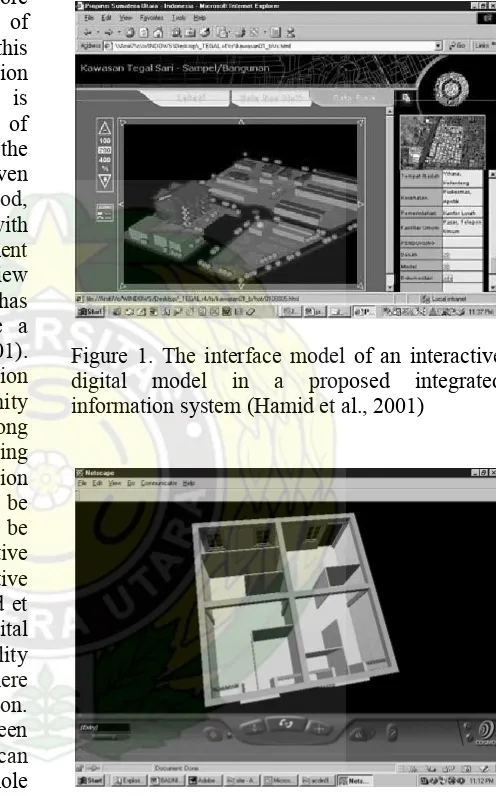
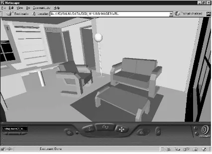
Visualization is one of the essential strategies in socializing planning and design phases concerning physical changes of a particular built environment. Design computation, or CAD (Computer Aided Design) in a more familiar terminology, is one of the more and more familiar tools for the implementation of visualization process. In its early stages this method is effective in bridging visual perception gap of a plan of a physical project. This is supported by the most recent development of digital modeling by CAD that enables the process to create a real simulation, and even tends to be exaggerated. In the next period, rational thinking of each person involved with urban development process or built-environment resettlement has stimulated a more critical view towards digital visualization method. This has the most effect among people who have a relatively higher education (Holmgren, 2001). Therefore it is recommended when visualization by computer will take effect in a community projects, people participation should be among the project implementation plan. By utilizing this strategy a more adaptable visual perception among the involved participants can be expected. One technical issue that should be considered is the utilization of interactive modeling that will be a more communicative alternative. An interface prototype by Hamid et al. (2001), which utilized interactive digital modeling by using VRML (Virtual Reality Modeling Language), has indicated that there has still been potential of digital visualization. The power of the digital model has been enhanced through attaching function that can enable viewers to explore model. Whole development process, from the large scale neighborhood revitalization context to the smallest one such as housing unit renovation, can be visually explored interactively through integrating 3D model produced with CAD application program with VRML model. This includes exploring revitalization process of the neighborhood interactively through digital model in a proposed integrated information system (Figure 1), customizing various alternatives of housing unit renovation through an interactive digital model developed with VRML (Figure 2), until exploring alternatives of interior arrangement of a renovated housing unit model in real time basis through VRML model
(Figure 3). This method has also been equipped with function for displaying related non-visual information by attaching hyperlinks to the model. The simplest method of displaying the interface so far is by using web-based presentation format.
Figure 1. The interface model of an interactive digital model in a proposed integrated information system (Hamid et al., 2001)
Figure 3. An interactive VRML model displaying a function where viewers can explore alternatives of interior arrangement of a renovated housing unit model in real time (Hamid et al., 2001)
The extension of the ability of each model is very dependent on level of competency in utilizing modeling application program. Building digital model doesn’t only mean digital drafting or drawing which essentially isn’t different from works produced by draftsman manually. Competency in CAD program is very much needed in representing complicated planning and design problems (Rosenman and Gero, 1997; Murty et al., 1999). The issue will be easily understood if all actions taken in planning and design are viewed as integrated parts in a process, not just an end product that is judged by final presentation. Complexity of planning and design problems mostly occurred on early process, where compilation and integration of basic information are executed. Information regarding administrative and technical aspects will be frequently found here. It is in this point that CAD can be utilized further not only as drafting tools, but able to perform its maximum capacity as analysis tool. Urban and environmental planning issues such as ecological or economical factors that have been beyond the scope of CAD works until recently, can be involved within digital analysis of a particular physical plan (Medjdoub and Yannou, 2000; Donath et al., 2002).
Complex model is a character of required model in representing complexity of urban physical problems. Integration of non-visual information within CAD model is a determinant factor to have a successful modeling project. Complexity
in urban planning and development cannot only be represented by visualization through digital model of the subjected revitalized area. The dynamics of information exploration in line with changes in urban planning and development needs more than visualization in the context of computation works. It needs multiple representations (Dave and Bishop, 2000). Geographic Information System (GIS) is an example of a dynamic information system, which is based on multiple representations principles. The integration of CAD into GIS is basically a basis for building and developing an integrated urban development information system.
Above all visualization should always be placed as foundation for communication aspects in representing most of urban problems. Mitchell (1995) has argued that visualization through using physical elements that has been familiar to targeted people as symbols of information in databases will be effective in the context of building sustainable information system.
4. Proposed Integrated Information System 4.1 A GIS-based Model
In the beginning of 21st century, researches in the area of the implementation of information and communication technology for community or public interests have been developing more conducive and adaptable system with local needs. While on the early periods information system available in public computation facility has a character as one-way information, on its progress it has developed as more interactive information system. By using GIS-based program the information system could be utilized in order to enable it in identifying local people needs (Ceccato and Snickars, 2000). The collected information isn’t only that of related with spatial planning matters. Socio-economic data or SEDB (Social Economic Database) of urban population is included as databases for the integrated information system in GIS format (Nicolson, 1998). The included aspects could be summarized as following:
a.
Facilities and services, including: education, health, childcare, emergency service, religious facility, recreational facility, and public transportation.c.
Population, including: population character, population projectiond.
Site and residential, including: number of dwellings, age and type of dwelling, available allocation, potential site for housing development, projection of housing needs in the future.Exploration of the development of GIS-based urban spatial and regional analysis has involved with more detailed information and having three dimensional performance representing urban elements and its implication, such as: specification of dwellings in a particular area and its related energy analysis (Holtier et al., 2000). People participation as part of attempts in increasing data quality, such as the information regarding their views and assessment of their environmental neighborhood, has been able to be accommodated through the use of Internet (Ceccato and Snickars, 2000). Therefore the idea of involving local people in the practice of making planning and implementing urban development program that is facilitated by IT is not merely theoretical anymore. The use of Internet, or strategy in supplying the IT’s ware that is affordable to people, or at least group of people, is one of some significant aspects to be explored further in implementing community participation. This should be following up in order to have a reliable representative and communal data.
Urban development planning and design, which is essentially a sequence of decision-making process, has been made more accommodative by GIS program. The large number of people involved in an urban development project that brings various interests and needs of information has placed GIS as important tool for decision-making – Design Decision Support (Batara et al., 2002). On this area, potential of GIS in exploring the tasks will be much more maximal by integrating it with CAD. This is to be done for enhancing its capability to perform multiple representations. The integration should also go beyond CAD by including the most recent communication medias, such as: the Internet, multimedia applications, etc.
4.2 Principles of Community-based Integrated Information System
The development of GIS has indicated a phenomenon of its separation with the development of spatial planning issues and the development of the IT as well. Ironically the GIS itself is essentially originated and developed by the supports of dynamics of both issues. In this case, concept of integration as a whole system should be carefully examined in line with the development of GIS as planning process aid tool. The complexity of issues in planning process needs a particular spatial analysis system that can include all related aspects. During last two years researches on GIS-based topics have been actively executed as anticipation of more and more complicated planning problems. System such as Planning Support System (PSS) has been identified as a model of more flexible and comprehensive GIS-based spatial analysis. It may facilitates wide range of spatial analysis from a small scale dynamic planning analysis, such as housing planning case (Donath and González, 2001) to a much more complicated issues such as the dynamics of urban planning itself, which requires a more adaptable and powerful IT tools (Geertman, 2002).
The implementation of hypermedia in collaborative urban planning and design should examine some factors that may influence quality of collaborative process and its resulted product. Shiffer (1995a) has explained there are at least three significant factors: information organization system covering documents that form databases, analysis tools and computation tools; facilities for accommodating and integrating multimedia aspects, such as: digital map, graphic aspects, audio and/or video aspects; and representation methods to enable maximum exploration of descriptive capability of each communication mode.
On a further research by Li and Yeh (2000), this multiple representation aspects have been developed through integration of what is called as Cellular Automata (CA) with GIS. Principally this method has opened the opportunity for integrating data not evolved through GIS program in order to hove extended flexibility in data formatting. Another important aspect is sustainability, which leads to an issue of how to integrate data updating methods with the system. While in the context of a developing country this application method is still long to be implemented widely, at least it offers an alternative to think research further about sustainability method of the integrated information system in local context.
5. The Urgency of Community Information Center
An urban information system will be useless without easy accessibility, particularly to bridge the information gap among the community. Therefore the system needs a method of accessing the information that can support a fair dissemination among the local people. An idea of developing local information center for local people who were always put aside in urban development socialization should be considered intensively in a framework of implementing fair dissemination of information.
As a model, local information center has had progressive attention in the end of the 1990’s. Essentially this facility isn’t far different from Internet café or Information Technology kiosks that have been familiar enough in most of Indonesian big cities. We will agree with this view if we look at their available devices or
tools and their function as a collective information access provider. But for a more strategic function as information provider or supplier, they aren’t function well or even nothing yet at all. In developed country itself, for instance in the United States, where level of information accessibility through Internet from each household is relatively higher than any other country in the world, it still needs a system of collective information access which is known as community computing program (Beamish, 1999). This program has accelerated dissemination of public information especially to low-income groups. In general, information system within public computing facility displays public information with local content, which is very urgent to be addressed to whole city inhabitants. In line with that function visualization in the information system use urban element symbols that have been familiar to local people as one of its power as digital communication media (Shaw and Shaw, 1999).
In a context of developing country, such as in Indonesia, computer wares are still considered expensive. It will be more contradictory if targeted functions of this machine are those of urban marginal people who clearly never thought the urgency of having it. Developing local information center for people needs critical thought in order to be able to manage wisely whole existing potential within people themselves or supports from concerned participants. The involvement of private sectors in giving contribution to provide adequate needs of computing facility should be considered as one potential resources. The strategy has been proved effective in solving the problems, in several cases within local communities in American metropolitans (Terry, 1999), and should be a precedence to be implemented in Indonesia. There are quite a number of large-scale national and multinational companies that use computer in large quantity and periodically upgrade those equipments. This is a very prospective opportunity that should be followed up in order to create a mechanism of developing community information centers.
urban development information system, the centers are projected to be data input nodes. Strategic managerial aspects are critical enough in operating such facility as these information centers, which are generally non-profit oriented. In their research on architectural education, Ozersay and Szalapaj (1999) have concluded that there is a room for academics involvement in managing the problems. It should be reminded to those academics that they have to make community works as part of their responsibility. All higher education institution in the world should have this kind of program to be considered an ideal university. A small case has been implemented in a local context in the city of Medan. An alternative of urban revitalization program has been utilized digitally through involvement of students (Hamid et al., 2001). A prototype of a system that may sustain the program by keeping updated the resulted model is currently under progress (Figure 4). This is underutilized by integrating all works with course works of computation courses conducted at Department of Architecture University of North Sumatra (Hamid, 2002).
Figure 4. A model of updating and maintenance mechanism in a proposed sustainable integrated information system (Hamid, 2002)
6. Conclusion
A model of computation in urban planning and design can be implemented through integrated information system, in which GIS has a role as basis for databases development. Equal accessibility of the available information on the system among whole participants in the implementation of urban development program is a significant factor to have a successful model. Local people should be given the most attention in designing the access system. Community information center can be considered as an ideal model to facilitate the accessibility of this group. Sustainability of this program including updating information and developing digital model databases can be executed by integrating the program with academic program within participating university which have related academic program, for instance: architecture or urban planning.
Acknowledgement
The author would like to mention following names for giving contribution in enriching substantial ideas of this paper: Ir. Tavip K. Mustafa for his input on the implementation and significant role of dynamics system in facilitating urban spatial development program; Devin Defriza, ST who has developed a prototype of integrated information system in which discussion about information system in this paper referred to
References
Batara, A., Dave, B. and Bishop, I. (2002) Design Decision Support through Translation between Multiple Representations of Spatial Data, in Proceedings of DDSS2002 – 6th International Conference on Design and Decision Support Systems in Architecture and Urban Planning, The Netherlands, Ellecom.
Beamish, A. (1999) Approaches to Community Computing: Bringing Technology to Low-Income Groups, in Donald A. Schön, Bish Sanyal, and William J. Mitchell (ed.), High Technology and Low-Income Groups, Cambridge, MIT Press, pp. 349-368.
Government
DATA
CIC = Community Information Center
UDIC = Urban Development Information Center
Academic Institution
Input and Feedback
M h i
Academic works instruction
Beauregard, R.A. (1996) Between Modernity and Postmodernity: The Ambiguous Position of U.S. Planning, in S. Campbell and S.S. Fainstein (ed.) Readings in Planning Theory, Oxford, Blackwell Publishers Ltd., pp. 213-233. Castells, M. (1999) The Informational City is a
Dual City: Can it be Reversed?, in Donald A. Schön, Bish Sanyal, and William J. Mitchell (ed.), High Technology and Low-Income Groups, Cambridge, MIT Press, pp. 25-41. Ceccato, V.A. and Snickars F. (2000) Adapting
GIS Technology to the Needs of Local Planning, in Environment and Planning B: Planning and Design, vol. 27, no. 6, pp. 923-937.
Dave, B and Bishop, I.D. (2000) Multiple Representations for Diverse Perspectives: Collaboration in Urban Design, in Proceedings of SDH2000 – 9th International Symposium on Spatial Data Handling, Beijing, August 10-12, 2000.
Dokonal, W. (2001) A Working Session on 3-D City Modeling, in Proceeding of the 19th Conference on Education in Computer Aided Architectural Design in Europe, Helsinki, August 29-31, 2001, pp. 417-422.
Donath, D. and González, L.F. (2001) Integrated Planning Support System for Low-Income Housing, in Dumont, G.G. (ed.), in SIGRADI 2001, Sociedad Iberoamericana de Gráfica Digital, Fifth International Conference on Digital Media in Design, Ediciones Universidas del Bio-Bio, 2001, pp. 113-116.
Donath, D., Lömker, T.M. and Richter, K., (2002) Plausibility in the Planning Process – Reason and Confidence in the Computer-Aided Design and Planning of Buildings, in Proceedings of ACADIA 2002 Conference, Los Angeles, USA, October 2002.
Geertman, S. (2002) Participatory Planning and GIS: a PSS to Bridge the Gap, in Environment and Planning B: Planning and Design, vol. 29, no. 1, pp. 21-35.
Gross, M., Parker, L. and Elliot, A. (1997) MUD: Exploring Trade-Offs in Urban Design, in R. Junge (ed.), CAAD Futures 1997, Netherlands, Kluwer Academic Publishers, pp. 373-387.
Hamid, B. et al. (2001) Sistem Informasi Terpadu Proyek Revitalisasi Kawasan Kota, Laporan Akhir Program Semi-QUE III Fakultas Teknik USU, Proyek Peningkatan Manajemen Pendidikan Tinggi (P2MPT), Ditjen Dikti, Depdiknas.
Hamid, B. (2002) The Role of Academia in Promoting and Sustaining Implementation of Information Technology in Urban Spatial Design and Management, in Proceeding of the 3rd International Seminar on Sustainable Environmental Architecture, 9-10 Maret 2002, Yogyakarta, Indonesia.
Holmgren, S., Rüdiger, B. and Tournay, B. (2001) The 3D-City Model – A New Space, in Proceeding of the 19th Conference on Education in Computer Aided Architectural Design in Europe, Helsinki, August 29-31, 2001, pp. 430-435.
Holtier, S., Steadman, J.P. and Smith, M.G.
(2000) Three-Dimensional Representation of Urban Built Form in a
GIS, in Environment and Planning B: Planning and Design, vol. 27, no. 1, pp. 51-72.
Li, X. and Yeh, A. G. (2000) Modelling SustainableUrban Development by the Integration of Constrained Cellular Automata and GIS, in International Journal of Geographical Information Science, vol. 14, no. 2, pp. 131-152. Maher, M.L., .Cicognani, A. and Simoff, S.
(1997) An Experimental Study of Computer Mediated Collaborative Design, in International Journal of Design Computing, vol. 1.
Medjdoub, B. and Yannou, B. (2000) Separating Topology and Geometry in Space Planning, in Computer-Aided Design, vol. 32, no. 1, pp. 39-61.
Muhammadi dkk (2001) Analisis Sistem Dinamis, Lingkungan Hidup, Sosial, Ekonomi, Manajemen, Jakarta, UMJ Press.
Murty, P., Chase, S. and Nappa, J. (1999) Evaluating the Complexity of CAD Models in Education and Practice, in CAADRIA 1999’ Proceedings of The Fourth Conference on Computer Aided Architectural Design Research in Asia, Shanghai, 5-7 May 1999.
Nicolson, K. (1998) Planning for People: Integrating Social GIS Data in Urban Planning, in GIS Asia Pacific, August/September, 1998, pp. 20-24. Ozersay, F. and Szalapaj, P. (1999), Theorising
a Sustainable Computer Aided Architectural Education Model, in Proceeding of the 17th Conference on Education in Computer Aided Architectural Design in Europe: Architectural Computing: From Turing to 2000, CAAD Research Unit, University of Liverpool, September 15-17, 1999.
Rosenman, M.A. and Gero, J.S. (1997) Collaborative CAD Modelling in Multidisciplinary Design Domains, in M.L. Maher, J.S. Gero and F. Sudweeks, Formal Aspects of Collaborative CAD, Key Centre of Design Computing, University of Sydney, Sydney, Australia, pp.387-404.
Shaw, A. and Shaw, M. (1999) Social Empowerment through Community Networks, in Donald A. Schön, Bish Sanyal, and William J. Mitchell (ed.), High Technology and Low-Income Groups, Cambridge, MIT Press, pp. 315-335.
Shiffer, M.J. (1995a) Environmental Review with Hypermedia Systems, in Environment and Planning B: Planning and Design, vol. 22, 1995a, pp. 359-372.
Shiffer, M.J. (1995b) Interactive Multimedia Planning Support: Moving from Stand-Alone Systems to the World Wide Web, in Environment and Planning: Planning and Design, vol. 22, pp. 649-664. Terry, S. (1999) Across the Great Divide, in Fast