Improving incomes of local people
through the sustainable harvesting of
timber
Findings from the Community-based production forest project
Improving incomes of local people through the sustainable harvesting of timber - Findings from the Community-based production forest project in Keo Seima, Cambodia
RECOFTC - The Center for People and Forests
Copyright © RECOFTC November 2015
Bangkok, Thailand
All photos courtesy of RECOFTC
Reproduction of this publication for educational or other non-commercial purposes is authorized without prior written permission from the copyright holders provided the source is fully acknowledged. Reproduction of this publication for resale or other commercial purposes is prohibited without written permission of the copyright holder.
This publication has been generously funded by the Ministry for Foreign Affairs of Finland. The views expressed in this publication are those of the authors and do not necessarily reflect the views of RECOFTC and our donor organizations.
For more information about RECOFTC’s ForInfo project,
Improving incomes of local people through the
sustainable harvesting of timber
Acknowledgments
Table of contents
INTRODUCTION
Project overview and partners involved
Project rationale and ForInfo project involvement Summary of project activities
Community-based production forestry management plan (CBPF-MP) Trial harvest proposal
FOREST INVENTORIES
Tables
Table 1. Comparison of different forest inventory methodologies Table 2. FA official equation to estimate standing timber Table 3. Comparison between PHI and forest inventory Table 4. Results of destructive sampling
Table 5. Comparison of photogrammetric analysis with timber equations Table 6. Annual volume increment for EF for a model in Lao PDR Table 7. Average prices of timber in Phnom Penh
Table 8. Breakdown of harvesting costs Table 9. Analysis of carbon pools
Table 10. Summary of carbon market options
Figures
Figure 1. Map of the CBPF area (showing the original potential area) Figure 2. New proposed boundary for the CBPF
Figure 3. K-tree plot
Acronyms
AHT Appropriate Harvesting Methods CBPF Community-Based Production Forest
CBPF-MP Community-Based Production Forest Management Plan
CF Community Forest
DBH Diameter at Breast Height (or 1.30 m)
DF Deciduous Forest
DHR Diameter-Height Relationship ELC Economic Land Concession
EF Evergreen Forest
FA Forestry Administration
ForInfo ForInfo: Livelihood Improvement Through Generation and Ownership of Forest Information by Local People in Products and Services Markets project
IGES Institute for Global Environmental Strategies MAFF Ministry of Agriculture, Forestry and Fisheries NFP National Forestry Programme
NTFP Non-timber forest product RIL Reduced Impact Logging
RECOFTC RECOFTC – The Center for People and Forests SPF Seima Protection Forest
Summary
The CBPF Keo Seima project began operating in 2006 in the buffer area of the Seima Protection Forest (SPF) in northeast Cambodia. It is a joint activity of WCS, the FA and the local communities in the area. Other organizations, namely RECOFTC, the Institute for Global Environmental Strategies (IGES) and the Rainforest Alliance also contributed significantly. The project’s aims were to implement sustainable forest management in the buffer zone of a significant protected area and to improve the income levels of local people through the sustainable harvesting of timber in areas directly operated by their communities. The project takes as an assumption that this approach will likely prevent the conversion of forests into agricultural tracts, and thus will also fulfill the conservation objectives of the SPF.
Many activities were carried out in in accord with the national community forestry legal framework, ranging from community organizing and management body election to the preparation of a community forest management plan. An additional activity, a trial harvest, was proposed to the Cambodian government, with the objective of testing, on a small scale, the feasibility of timber production, determining the training needs of stakeholders and beginning to develop the capacities of the local people.
Introduction
Project overview and partners
The Community-based Production Forestry (CBPF) Keo Seima project operated in the buffer area of the Seima Protection Forest (SPF), which is located in northeast Cambodia. The development phases started in early 2006. In 2010, the project was incorporated into the National Forestry Program of Cambodia, receiving a green light for the full implementation of the model. The project was implemented as a joint activity of the Forestry Administration (FA), the Wildlife Conservation Society (WCS) and the local communities of the area. RECOFTC – The Center for People and Forests joined as a partner at the end of 2010 and the Rainforest Alliance joined in 2013. Part of the project’s funding came from RECOFTC and the Institute for Global Environmental Strategies (IGES).
Project rationale and ForInfo project involvement
The CBPF Keo Seima project’s aim was to implement sustainable forest management (SFM) in the buffer zone of a significant protected area by creating community-based production forest (CBPF) in the area. The main objective was to improve the incomes of local people through the sustainable harvesting of timber, which would also prevent the conversion of forests into agricultural land, thereby fulfilling the conservation objectives of the SPF.
RECOFTC is currently implementing a four-year project, “ForInfo: Livelihood Improvement Through Generation and Ownership of Forest Information by Local People in Products and Services Markets”, which is funded by Finland’s Ministry of Foreign Affairs. The project links several sites in the Lower Mekong countries (Cambodia, Lao PDR, Thailand and Viet Nam) to enable them to exchange, adapt and improve the best practices used by local people and communities in the generation of forest-related information about how they secure and maximize the benefits that they derive from forest resources.
Cambodia has one of the highest levels of forest cover in Southeast Asia. According to the forest cover assessment carried out by the Forestry Administration (FA) of the Cambodian Ministry of Agriculture, Forestry and Fisheries (MAFF) in 2010, the country was covered by around 10.36 million hectares of forest representing approximately 57 percent of the total land area.1 But while the percentage of land area
covered by forest is relatively high, the same study shows a steady deforestation rate of approximately 0.5 percent per year over the last decade, which is why Cambodia has been classified as a REDD+2
“high forest cover, high deforestation” country. To reduce the country’s high rate of deforestation, the Cambodian government is supporting community forestry by setting a goal of allocating 2 000 000 hectares of forest to communities as community forest by 2030,3 and is pushing to reach this goal with
the help of many aid organizations and international donors.
The CBPF Keo Seima project was therefore a perfect fit for the ForInfo project’s rationale: helping local communities accessing the timber market in Cambodia in a sustainable way and delivering both socio-economic and environmental benefits. The local timber market is mostly dominated either by legal sources, which are, however, unsustainable, such as forest clearings for Economic Land Concessions (ELCs), or by illegal sources, such as illegal loggings by companies. Precise estimates of the total timber harvested in the country are unavailable due to the shady nature of many timber operations, but timber harvesting is commonly understood to be one of the largest economic activities in the country. Newspapers and human rights watchdogs are frequently reporting on conflicts due to ELCs displacing local people by harvesting timber outside their declared areas or due to local officers being involved in the illegal trading of luxury timber. Production and harvesting of timber by community forests would be a first step towards a more sustainable and equitable timber market in Cambodia.
1 FA 2011, “Forestry Administration Annual Report,” Phnom Penh, Cambodia. 2 UN-REDD 2011, “Cambodia National UN-REDD National Programme Document,”
URL: www.unredd.net/index.php?option=com_docman&task=doc_view&gid=7388 [Accessed 19/09/2014]. Phnom Penh, Cambodia.
Many examples show that community-run timber enterprises are successful in both improving the livelihoods of local people and in sustaining forest resources. The Rainforest Alliance has facilitated many such enterprises in the Peten Region of the Maya Biosphere Reserves of Guatemala. Research has shown that the forest concession areas under community management have lower rates of deforestation than neighboring conservation areas that are under strict government control.4,5 Moreover, study in Cambodia
showed that community forests are more successful when established in good value forests with existing forest-dependent communities,6 which was the case for the SPF.
Summary of project activities
This CBPF Keo Seima project, a pilot project, was a major groundbreaking activity for Southeast Asia as no commercial timber harvesting has ever been carried out by a community forest within the region. According to the standard Cambodian national framework for community forestry, the project first needed to secure the land rights of the area for the communities involved through a community forest agreement signed with the Cambodian government. The next step was to facilitate the preparation of a community forest management plan (CFMP). As an additional activity, a small trial harvest was planned to be carried out at the same time the CFMP was being prepared. This activity should be planned, because even if local communities are widely harvesting timber for customary uses, the real financial, social and technical feasibility of a community-led commercial-scale operation must also be verified through the trial harvest tool. Technical and financial assistance is then provided until local capacity is developed and the community enterprise is able to operate independently. A trial harvest provides valuable information on these needs.
The possibility of entering the carbon credit market was also explored. A separate project jointly managed by the FA and WCS was already underway in the Core Area of the SPF. Its aim was to sell credits under the voluntary carbon market standards. Experiences and lessons learned could easily be transferred between the projects. Full protection measures were enforced inside the Core Area and no exploitation of timber resources were allowed. The objective of the Keo Seima CBPF was to develop a methodology that could be implemented in tandem with commercial harvesting. The methodology generated was expected to provide additional, significant profits related to timber sales while also covering the extra costs generated for its preparation.
4 Radachowsky J., H. Ramos V.H., McNab R., Baur E.H, Kazakov N., 2012. “Forest concessions in the Maya Biosphere Reserve, Guatemala:
A decade later.” Forest Ecology and Management, Vol. 268, 18–28. Amsterdam, Netherlands.
5 Bray, D. B., E. Duran, V. H. Ramos, J.-F. Mas, A. Velazquez, R. B. McNab, D. Barry, and Radachowsky J., 2008. “Tropical deforestation,
community forests, and protected areas in the Maya Forest.” Ecology and Society 13(2): 56. [online] URL: http://www.ecologyandsociety. org/vol13/iss2/art56/.
6 Lambrick F.H., Brown N.D., Lawrence A., and Bebber D.P., 2014. “Effectiveness of Community Forestry in Prey Long Forest, Cambodia.”
Overview of site
History
The Keo Seima CBPF area is located in the buffer area of the SPF, which is a Permanent Forest Estate under the jurisdiction of the FA. Indigenous Bunong villages have been present in the area at or near their current locations for many decades, and in some cases, centuries. These villages reserve the legal right to claim certain areas in the SPF, such as residential land and farmland, by authority of community land titles.7
Although the Khmer Rouge regime removed the local people from the area in the early 1970s, families gradually returned 10-20 years later when the area became safe to inhabit once again.8 During this period,
the SPF area experienced significant logging of high-value species, a problem which continued after it was placed under the Samling International logging concession in 1994. These logging activities harmed the local communities, especially through the loss of resin trees. In 2000, a nationwide logging concession moratorium was put in place and Samling’s operations ceased. In 2002, much of the concession was declared as the Seima Biodiversity Conservation Area by virtue of a ministerial decree, and the area began to also benefit from a new conservation project. In 2009, the Council of Ministers upgraded the legal status of the entire reserve to “Protection Forest.” The location of the CBPF Keo Seima project was then given “Buffer Protection Forest” status, which allows human activities to continue for as long as they are consistent with the conservation goals of the area.9
Site characteristics
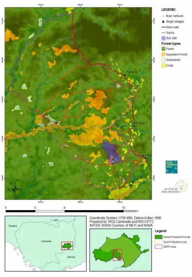
The CBPF Keo Seima project site is situated in Mondulkiri Province in northeast Cambodia close to the country’s border with Viet Nam (Figure 1). The total area of the project site covers around 9 660 hectares (ha), mostly of logged evergreen and semi-evergreen forest (6 475 ha) with a high percentage of trees from the genus Lagerstroemia (local name: Sralao). This species is considered to be an indicator of past disturbances since it grows mainly in denuded areas and its growth in mature forests is limited to large openings.10 The timber can obtain good market prices (around US$ 400/m3 for rough boards used mainly
for flooring) but not as high-value as other commercial species. The trunk often has a twisted shape with large buttresses and is frequently hollow near the bottom (sometimes up to a considerable trunk height). Other species present in various percentages are: Beng (Afzelia xylocarpa), Chambark (unidentified),
Chhoeuteal (Dipterocarpus alatus), Choor chung (Shorea vulgaris), Kakah (Sindora cochinchinensis),
Kampingreach (Sandoricum indicum), Koki (Hopea odorata), Koulen (unidentified), Neang Noun
(Dalbergia bariensis) and Phdiek (Anisoptera costata).
Around 1 050 ha of mixed, dry, deciduous forest cover is dominated by Chhlik (Terminalia alata), Khlong (Dipterocarpus tuberculatus), Phchek (Shorea obtusa), Raing phnom (Shorea siamensis), Sokram (Xylia dolabriformis) and Trach (unidentified). The CBPF Keo Seima project site also includes smaller areas of wetland, natural grassland and riparian vegetation, which are important wildlife habitats. The area is generally flat or comprised of gently rolling hills with elevation ranging from 100 to 200 meters (m) above sea level.
The CBPF Keo Seima project site lies close to the Southern Economic Corridor of the Greater Mekong Sub-region, a natural economic area bound together by the Mekong River, which covering 2.6 million square
7 Evans T, Thannarak C, Mesa H, Trey E, Mohns B, de Bruyn T, Bianchi S, and Dedinas K, 2011, “Action learning for Community Carbon
Accounting in Seima Protection Forest, Cambodia,” Wildlife Conservation Society, Forestry Administration and RECOFTC, Phnom Penh, Cambodia.
8 Pollard E H B, and Evans T, 2008, “A Survey of communities in and around the Seima Biodiversity Conservation area in 2008,” Wildlife
Conservation Society. Phnom Penh, Cambodia.
9 Ibid, 7.
10 Blanc L, Maury-Lechon G, and Pascal J-P, 2000, “Structure, floristic composition and natural regeneration in the forests of Cat Tien
kilometers and a combined population of around 326 million.11 It is widely recognized that grassroots
mobilization is vital to establish the Corridor both fairly and successfully, and both the public and private sectors, including local communities and small businesses, must actively participate in its development.12
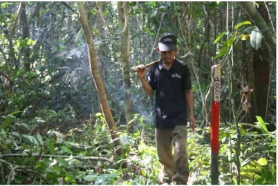
Patch of young Sralao trees.
Beneficiaries of the project
Three villages were actively involved since the beginning of the project: Pu Char, Ou Chra and Pu Kong. Each has a majority population of indigenous Bunong, totaling 750 persons comprising 158 households. Each household joined the Keo Seima CBPF and around 45 percent of the inhabitants are subscribing members. The great majority of these people follow a mixed livelihood strategy based on farming and collecting liquid resin from wild dipterocarp trees. Rainfed lowland rice is the predominant farming system with some partly fixed and partly rotational upland agriculture. Livelihood surveys consistently show that resin tapping is of crucial importance; it is conducted by more than 80 percent of families and adds up to 30-50 percent of the total livelihood value for many of them. Cash crops like cassava have also been introduced to the area. The area’s poverty rate is high and literacy rate is very low.
Several clearings in the forest for new “chamkar” (local name for cash crop farms) have also been observed. Residents of villages around the site use the area for the collection of many forest products as well as for spiritual reasons. Resin trees are found throughout the area and are owned by individual families. People fish extensively in the rivers and pools inside the site. A wide diversity of non-timber forest products (NTFPs) is also collected for subsistence use and to sell. The villages also recognize certain areas of the site as spirit forest.13
11 Asia Development Bank, “Overview of the Greater Mekong Subregion,” http://www.adb.org/countries/gms/overview [Accessed:
18/10/14].
12 Wiemer C, 2009, “Economic Corridors for the Greater Mekong Subregion,” Background Brief No. 479., East Asia Institute. 13 Evans T, Thannarak C, Mesa H, Trey E, Mohns B, de Bruyn T, Bianchi S, and Dedinas K, 2011, “Action learning for Community Carbon
Community forestry process
Steps for community forest recognition
WCS facilitators have been intensively engaging with the local communities in the CBPF Keo Seima project area for many years. After introducing the project and reaching a consensus, they facilitated all the necessary procedures to acquire legal recognition in accordance with the Cambodian National Forestry Programme (NFP). The required steps were as follows:
Step 0: Identification of potential area Step 1: Community forest establishment Step 2: Information gathering
Step 3: Establishment of the community forest management committee (CFMC) structure Step 4: Preparation of CFMC by-laws and recognition by the Commune Council
Step 5: Demarcation of community forest boundary and mapping Step 6: Preparation of community forest regulations
Step 7: Preparation and approval of the community forest agreement
Once step 7 is reached, all of the previously prepared documents are sent to the FA for final approval. If all the documents are considered correct, the community forest agreement is signed both by the FA and the local communities. The community forest Agreement provides the local communities with the management rights to the forest area for the next 15 years. The FA will approve renewal of the agreement after this period only if the community forest’s activities are positively reviewed.
The CBPF Keo Seima project area communities completed the administrative steps 1 to 6 with the guidance of WCS facilitators. All the management subcommittees at the village level and one joint management committee were elected, their by-laws prepared and the CBPF regulations were discussed with all the members. Unfortunately, however, major problems arose in identifying the potential area (Step 0), which resulted in lengthy delays to all other steps.
When the Keo Seima CBPF initiated activities, the FA classified the project area as Production Forest. Commercial timber harvesting carried out based on SFM principles were permitted at the time. Over the course of the project, new regulations were issued and the area became Protection Forest, which means only traditional use of forest resources is allowed including in areas inside the buffer zone. This made the FA very reluctant in approving a project involving commercial timber harvesting.
At the same time and in the same area, an ELC was also established, which overlapped with a large portion of the CBPF site, especially where the most promising forest stands were located. This development was a major threat to the project as well as a contradiction of the laws applied to the communities, as described above. Following the establishment of the ELC, the communities wrote a common letter bearing the signatures of a large number of the CBPF members complaining about the ELC taking their land. An agreement was then reached with the government, but it involved reducing the CBPF potential area from the 12 000 ha identified by stakeholders and the FA at the beginning of the project (the border displayed in Figure 1) to the revised project area of 9 660 ha (Figure 2).
Community meeting held by WCS facilitators.
Community-based production forestry management plan (CBPF-MP)
After a community forest is officially recognized, the planning and implementation of management activities can begin with the following steps:
Step 8: Preparation of community forest management plan Step 9: Enterprise development
Step 10: Implementation of the community forest management plan Step 11: Monitoring and evaluation
During the implementation of the CBPF Keo Seima project, it was agreed with the FA that the management planning process should start before reaching the official community forest agreement. This is common practice in Cambodia and has been applied by the FA in other cases14 to speed up the lengthy process of
community forest establishment.
Two zones were identified in the CBPF area to be used for training implementation. One makes up 264 ha in evergreen and semi-evergreen forest (EF) and another, 69 ha in deciduous forest (DF). These zones were used as locations to test inventory methods and the capacities of the local communities. Due to both financial and time constraints, it was originally envisioned that a small community-based production forestry management plan (CBPF-MP) could be initially prepared for those zones and expanded to the rest of the project area when more resources became available. The forest inventories carried out for the CBPF-MP in the EF and the information they provided are discussed in detail in the next chapter. A draft management plan was eventually prepared and discussed with the CBPF members. Preparation work for a trial harvest then became the dominant discussion topic. The CBPF-MP was thus put on standby in order to incorporate the lessons gained in the pilot harvest.
14 Similar to the UNDP-GEF-funded and RECOFTC-implemented Strengthening Sustainable Forest Management and Bio-Energy Markets
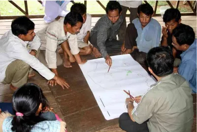
Community members engaged in a participatory mapping activity.
Trial harvest proposal
The original feasibility study15 and subsequent analysis carried out by the CBFP Keo Seima project team
demonstrated the high market potential of the area’s forest. A good standing timber stock of commercial species that could gain good prices on the market (see the chapters below for more details) is present in the CBPF area. However, several technical and legal constraints were also identified:
• The local communities have experience in felling and processing timber, but the current timber flow process used by the communities to harvest trees for customary uses is neither time- nor money-efficient for application in full-scale operations. In addition, safety measures are lacking. • The present Forestry Law forbids the primary processing of logs in the forest.
• The communities do not have the capability to engage in several key logging activities, such as the skidding of whole round logs out of the forest. Although local forest contractors with trucks or tractors can be hired, the following conditions may arise: a) contractor prices are extremely high, effectively swindling communities (as much as US$ 85/m3 has previously been charged by local
contracts only to transport timber from the forest to the village); b) the local communities do not have experience in working with selective logging operations and Reduced Impact Logging (RIL) techniques; and, c) CBPF members, fearing misconduct and subsequent removal of community forest rights, would rather not have external companies operating in their forest.
The trial harvest was envisioned to test out, on a small scale, some of the key activities that would be included in the management plan, such as annual-operation planning, harvesting techniques, sales and benefit sharing. This testing was suitable for a site where large operations are foreseen for the future but community capacity remains low and methods are still in development. The main objectives of the trial harvest were:
• Deliver capacity development, through action learning methods, on the technical aspects of timber harvesting to CBPF members;
• Provide an initial source of direct income to the CBPF in order to build community commitment and help fund future activities, such as the patrols, demarcation and forest-inventory keeping; • Determine the accuracy of the allowable cut calculations and cost estimates for use in financial
modeling;
• Begin building links with market operators and the private sector; • Test various approaches to forest harvesting;
• Evaluate the capacities of community stakeholders and government counterparts and identify their training needs;
• Assess levels of harvest damage to improve knowledge on carbon emissions; • Analyze operational and logging costs;
• Establish administrative procedures for enterprise management; and, • Understand procedures for legal compliance.
Communities under the leadership of the respective elected CBPF management committee (CBPF-MC) conducted full trial harvest activities e.g. forest inventory, carbon emission assessment, financial analysis of operational and logging costs, etc. with technical support from the FA, WCS, RECOFTC, and RA. An official request was made to the FA to move forward with the preparation and implementation of a CBPF harvesting plan, which the FA approved. Since Cambodia’s community forestry regulations do not cover in detail timber harvesting for commercial purposes in Cambodia, the FA required the forest concession system manuals – on which they have more practical knowledge – to serve as the basis for the preparation of the CBPF harvesting plan. The CBPF team followed the manual’s requirements, but as extensively discussed in this document, this system will prove difficult to apply under community conditions.
15 Blackett H, 2008, “A study of the Cambodia timber trade: Market analysis for the commercial community forestry project.” Wildlife
Forest inventories
Analysis of the community forestry regulations for the management
plan
In order to write the CBPF-MP, the current community forestry regulations in Cambodia require a general forest inventory with a three percent sampling intensity for EF. Plots must be laid-out using a systematic design. Their dimensions are 100 m x 50 m where trees more than 30 cm DBH are measured by recording their species, DBH and crown height. Nesting inside the main plot is a smaller plot measuring 50 m x 50 m for medium trees, where all individuals with 10-29 cm DBH are recorded (only species and DBH). Regeneration and NTFPs are measured in a 5m x 5m plot. The area is to be inventoried at the beginning of the community forest agreement and the resulting data used for the next 15 years of planning.
Considering the 6 475 ha of EF present in the Keo Seima CBPF, 380 plots were required to reach a three percent sampling intensity (190 ha). According to personal communications with RECOFTC’s Cambodia Country Program staff involved in many of these inventories, on average, only one plot per team is possible during a day’s work, which includes travel time, setting plot boundaries and collecting information. Considering that such a team is composed of eight to ten community members, it is impossible – without even yet considering the financial burden of this activity – for the communities to mobilize the human resources required to complete the work within a limited amount of time. The following solutions were suggested to simplify the technical requirements and speed up the process without reducing the accuracy of results:
1) Partitioning the area of the CFMP and progressively scaling up (as already suggested starting in the 264 ha test area previously identified);
2) Building Diameter-Height Relationship (DHR) instead of measuring the height of all trees more than 30 cm DBH; and,
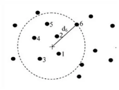
3) Implementing a different plot layout, specifically the k-tree plot.
During the CFMP forest inventory, the above solutions were tested and produced the following results: 1) Partitioning the area into smaller zones was accepted by the FA in principle, but because the
CBPF-MP for the 264 ha was not officially submitted to the FA, it was not thoroughly tested.
2) The DBH-height relationship produced results comparable to full height measurements but with large savings in time requirements.
3) The results of k-tree plots are discussed in detail in the following sections.
Description of the k-tree method
Figure 3. K-tree plot
Uncorrected K-tree sampling designs have an inherent bias by overestimating the plot volume since the last tree is always located on the plot’s perimeter.17 The degree of bias depends on the pattern spacing
of the trees, which varies by site. Various methods for partially correcting this bias are suggested in the literature on the subject, but none are universally effective. In this case, the project team decided to record the distance and DBH for every seventh tree. The bias was then corrected using an average radius between the sixth and seventh trees.18 Given the expected sampling efficiency of the method – and the
fact that it is recommended by many authors in cases where a small bias is considered acceptable – the project team decided to conduct a trial. To comply with the community forestry regulations, two different circular plots were laid out for big trees (DBH more than 30 cm) and small trees (DBH between 10 cm and 29 cm). Regeneration and NTFP were then measured in a fixed 5 m-radius subplot.
Comparison of methodologies
During 2010, in the same area (190 ha of well stocked EF), both k-tree and community forestry regulations methodologies were tested. Twelve standard rectangular plots and 60 k-tree plots were required to reach the three percent sampling size required in both systems. The required number of k-tree plots was estimated after several tests in the forest indicated the average plot size. The final results of the inventories are shown in Table 1.
Table 1. Comparison of the community forestry guidelines and k-tree methodologies.
Parameter Community forestry
guidelines
Six-tree method
Number of plots 12 60
Average plot size (ha), trees ≥30 cm 0.50 0.14
Sample fraction for trees ≥30 cm 3.2% 4.4%
Survey time (person/hour/ha) 3.0 2.3
Survey costs ($/ha) 4 3
Stem count (trees/ha) 394 336
Basal area (m2/ha) 16.8 24.4
Timber volume (m3/ha) 123.2 179.4
17 Magnussen, S, Kleinn, C and Picard, N, 2008, “Two new density estimators for distance sampling,” European Journal of Forest
Research, Vol. 127, pp. 213–224.
18 Kleinn, C and Vilcko, F, 2006, “A new empirical approach for estimation in k-tree sampling,” Forest Ecology and Management, Vol.
The k-tree methodology led to the best results in terms of time efficiency. Even if the number of plots were five times more and resulted in a higher sampling density due to the larger than expected average area, the method’s simplicity of execution meant a savings of around 24 percent in terms of total time required, compared to the time needed when using the community forestry guidelines. This translates to considerable savings on inventory costs where field labor is one of the most expensive budget lines. It also means a better level of engagement from communities since they can complete the work faster with less turnover. It is important to remember that the relative survey cost per ha may seem small, particularly when compared to the potential value of the timber harvestable, but the main problem for a community enterprise is to pay that sum up front and mobilize all its human resources in time.
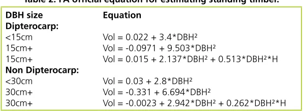
To estimate timber volume, the official FA equations were applied in both cases, as shown in Table 2.19 Height (H) as used in all equations refers to commercial height. This data was recorded in both
methodologies (either directly or using DBH-Height regressions) but some confusion arose between operators regarding the definition. Teams may have measured the point of the trunk where it reached a minimum 20 cm diameter as stated in the community forestry regulations, regardless of the tree’s real quality. However, in the Forest Concession manual where the equations are described, commercial height refers to the general height covering the area of the trunk that can be utilized. To avoid discrepancies, the project team used the equation limited to the use of DBH.
Table 2. FA official equation for estimating standing timber. DBH size
Vol = 0.015 + 2.137*DBH² + 0.513*DBH²*H
Vol = 0.03 + 2.8*DBH² Vol = -0.331 + 6.694*DBH²
Vol = -0.0023 + 2.942*DBH² + 0.262*DBH²*H
The main differences between the two methodologies were in the estimated total Basal Area and in timber volume figures. More big trees were measured in the k-tree plots, which the project team believes is due to a minority of small, scattered, highly stocked Sralao stands that were not detected in the community forestry guidelines-based sample, while the k-tree plots were more accurately surveyed in the forest. (Big Sralao trees are indeed often seen clumped together in small patches.) Together with the reduced cost of in inventory taking, this led the team to consider the six-tree method as the better of the two methods. Further analysis on this point is discussed in the sections below.
19 Department of Forestry and Wildlife, 2003. “Forest systems research and modeling handbook,” Document 3, Regional Volume Table.
CBPF member learns how to measure tree height (Makino Yamanoshita).
Pre-harvest inventory
For the CBPF harvesting plan, a pre-harvest inventory (PHI) was required from the FA so to determine the precise timber volume in the coupe, to calculate the sustainable harvestable quota and to plot the location of all trees in order to plan detailed operations. The PHI is a full inventory of all trees in a designated harvesting coupe. The trial harvest coupe proposed to the FA was 1 km x 0.6 km (60 ha) and 12 parallel strips had to be laid out every 50 m, each strip being 1 km long. Poles were planted at the center of the strip every 25 m and the vegetation – undergrowth, climbers and vines – cleared when necessary. Other poles were planted on both sides at a distance of 25 m from the center of the line to mark the boundaries of each strip. Compasses and the traditional three-pole method were used to assure straight and parallel lines. In six strips, additional four plots each were deployed to measure small trees (DBH 5 cm to 14 cm, plots size 10 x 25 m) and medium trees (DBH 15 cm to 29 cm, plot size 10 x 50 m). For trees more than 30 cm in DBH, the parameters measured were: species, DBH, commercial height,20 quality and location
(expressed in X and Y meters, estimated from the center and the beginning of the strip). All of the trees were tagged with metal plates to ensure proper identification. For the other trees in the rectangular plots (from DBH 5 cm to 29 cm) the parameters were: species, DBH, crown height and quality.
This activity was very time consuming, which was partly due to the inexperience of the participants in conducting such an inventory. Before beginning the inventory taking, the project team planned that each single team would layout their strips and simultaneously measure the trees these strips contained. A small sub-team would advance to the front preparing the strips while the second sub-team would follow by collecting the data. The project team found this system impossible to use after the first trial due to difficult conditions prevalent in the area that included small patches of impenetrable forest, inadequate worker inexperience and strips laid out that were not parallel to each other. After a discussion with the communities, it was decided to change methods and use a two-step process: 1) all teams working together to layout the strips; then, 2) all teams conducting data collection activities. In this way, the strips were more carefully laid-out and adjacent teams could help each other to proceed parallel. The achieved a very good layout of the strips but at the cost of consuming a large amount of time with most of it spent cutting vines and climbers.
Laying out PHI strips.
Data collection proceeded with fewer problems. Several community members had already acquired experience in previous general inventories. Particular attention was given in measuring the precise diameter of buttressed trees (carried out at 4 m above the ground using an optical wedge) and the commercial heights of valuable species. External experts in species identification joined the teams in assigning Cambodian and scientific names to all the trees (community members sometimes know only the local Bhnong names). Teams were asked to visually select the most promising commercial trees (candidate trees) directly from the field where a good evaluation of tree quality, harvesting potential and potential logging difficulties due to location could be performed better in the field. It was suggested that during the succeeding data processing and tree selection, priority should be given to the identified candidate trees.
The results of the PHI, shown in Table 3, are compared to the other two systems tested during the general forest inventory. The comparison is based only on the plots of the general forest inventory carried out inside the trial harvest area.
Table 3. Comparison of PHI, community forestry guidelines and k-tree forest inventory methods.
Parameter PHI Community forestry
guidelines
Six-tree method
Number of plots n/a 3 14
Sample fraction for trees ≥30 cm 100% 2.5% 3%
Survey time (person/day/ha) 12.9 -
-Stem count (trees/ha) 597 399 321
Basal area (m2/ha) 22.1 22.1 25.4
The same set of FA equations was used to estimate the volume. Commercial height was used as an additional parameter for trees more than 30 cm DBH in the PHI approach, giving rise to a slightly different methodology. The PHI results more closely resemble the community forestry guidelines system with a difference of only of 0.6 m3/ha compared to the k-tree plots, which overestimate the volume by as much
as 38 m3/ha. This is due principally to a large difference in the number of big trees found using the
different methods.
The survey time required was extremely high at around 13 persons/day/ha. Considering the food, travel costs and the expensive daily spending allowances to be paid to FA officers supervising the work of communities, the fieldwork total cost ranges from US$ 120/ha to US$ 150/ha. Community members also received a daily salary since teams were camping in the forest and working full time for several days at a time instead of taking care of primary livelihood activities.
Discussion on the preciseness of inventories
The large difference between the results of the k-tree plots in the test coupe and the PHI was surprising. Possible explanations could be found in the difficult character of the forest, human error and inconsistencies between methodologies. It is possible that the measurers have included more big trees than small ones in the k-tree survey, unconsciously moving towards them when they should otherwise have not been included. Errors like this are common during forest inventories, especially if the data collectors were not aware of the importance of statistical precision or simply because they were working in a complex forest environment. In addition, the DBH of big trees could have been affected heavily by the presence of buttresses. In both cases, it was suggested to measure the diameter at a standard height of 4 m using an optical wedge. In the PHI approach, this technique was always used for every buttressed tree but the project team is not sure if it was implemented for all trees inventoried in the k-tree plots. In the latter case, methodology may have been less strict in application and the data collectors may sometimes have measured diameter at a height less than 4 m, thus getting a larger measurement.
Additional experimental research
Research was carried out during the project’s lifetime to verify the precision of the FA equations in estimating timber volume. Two different means were used: destructive sampling and photogrammetric analysis. The former is the most common method for such studies because it is highly precise in calculating timber volume and biomass; however, it is expensive and generally applicable only for small samples. The latter is a new technique, possibly cheaper and applicable to larger samples, and it was tested to verify its accuracy and applicability.
Destructive sampling
Table 4. Results of destructive sampling.
The volume estimated from the FA equation, based only on diameter, is lower than the real one, with a total cumulative error of 65 percent. The project team expects the results of the CFMP inventory to be extremely conservative. When commercial height was included in the prediction, the total error decreased to 39 percent. This will reduce the errors during the pre-harvest inventory when a more detailed estimation is needed. However, the number is still a large discrepancy that could lead to serious problems when calculating the allowable cut and planning harvesting operations.
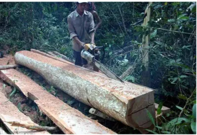
Processing on the felling site.
on the ground (which would be lower) to study the discrepancies from inventory results and actual commercial timber produced. It is clear that a proper system to identify hollow trees during the PHI should be applied, together with the identification of new possible innovative products that could reduce the waste materials. An example of the latter is shown in the photo below.
Hollow tree stumps as small coffee tables, Thailand
Photogrammetric analysis
For this approach, sample trees were chosen non-randomly inside or outside the CBPF area. Choice of trees were based on the following criteria:
• Tree originally grew in a forest environment (in forest now or in recently deforested area); • Tree is accessible at the base;
• Tree can be viewed and photographed clearly from two directions; and,
• Tree is within the same general area, forest type and altitudinal belt as the CBPF area.
Figure 4. Photogrammetric analysis.
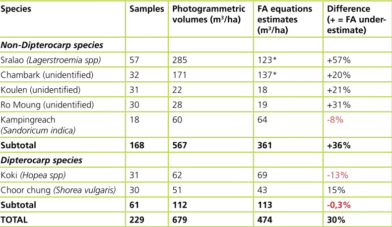
Using this technique, 229 trees were analyzed. Commercial volume was calculated as the portion of the trunk starting at 30 cm from the bottom (for trees less than 80 cm DBH) or 3 m (for trees more than 80 cm DBH, to address the problem of buttresses, rotten heart wood and expected cracks when felling the tree), and up to where it reaches a 20 cm diameter. The commercial volume was then compared with the volume estimated by standard FA equations for Dipterocarp species and for non-Dipterocarps. The comparisons between the two estimations are presented in Table 5.
Table 5. Comparison of photogrammetric analysis with timber equations.
Species Samples Photogrammetric
Sralao (Lagerstroemia spp) 57 285 123* +57%
Chambark (unidentified) 32 171 137* +20%
Koulen (unidentified) 31 22 18 +21%
Ro Moung (unidentified) 30 28 19 +31%
Kampingreach
Choor chung (Shorea vulgaris) 30 51 43 15%
Subtotal 61 112 113 -0,3%
TOTAL 229 679 474 30%
61 trees were analyzed for the Dipterocarp species. Their cumulative volume calculated from photos and the volume estimated using FA equations is almost identical. On the contrary, for 168 non-Dipterocarp species trees, the accumulated result using FA estimations is 36 percent less than the photogrammetric volume, with the highest error for Lagerstroemia.
Volume increment analysis
Preliminary studies carried out by the FA show that the volume increment per year for EF, sampling only trees with more than 30 cm DBH, is around 1.2 m3/ha (when less than 20 of such trees are present per
hectare) to 2.2 m3/ha (more than 20 trees/ha DBH > 30 cm).21 The study was carried only on a limited
set of samples and time intervals and it was suggested by the authors that the method be refined and improved in the future. A more recent study in Cambodia22 resulted in an annual increment of 2.4 m3/ha
(previously logged EF) and 0.7 m3/ha (unlogged EF), again using only trees more than 30 cm DBH. Even
if the categories are not exactly coincident, the trend seems to be inverted compared to the previous data (less big trees are expected in a previously logged forest). A proposed revision of the manual for the CFMP process (still unpublished pending approval by the FA) suggests using growth data sourced from neighboring Lao PDR23 as indicated in Table 6. Those figures take into consideration all trees and include
losses from mortality.
Table 6. Annual volume increment for EF for a model from Lao PDR.
Annual net stand growth at different stand densities (m3/ha)
Stand volume 70 80 90 100 110 120 130 140 150 160
Net stand growth 3.07 3.14 3.16 3.14 3.08 2.98 2.85 2.71 2.54 2.37
The project team was concerned that there will not be enough volume increment to sustain the repetition of operations during a 30-year cycle and so the team tried to refine the data above by measuring the ring growth of the Sralao trees that were destructively sampled in the previous activity. Unfortunately, the sample size was too small and technical difficulties arose due to the irregular shape and presence of hollows, which made measurements problematic. Preliminary results showed an annual DBH increment of 0.4-0.5 cm/year. If such growth is applied to the forest inventory data of the CBPF, the resulting volume increment is comparable to the one indicated in Table 6. Those results were deemed inconclusive and more work is needed on this aspect.
Another concern is based not only on regeneration in terms of volume but in terms of commercial species. This is a concern shared for other tropical forests subjected to selective harvesting where the risk to deplete the forest of valuable species must be considered when planning silvicultural operations.
21 Department of Forestry and Wildlife, 2003. “Forest systems research and modeling handbook,” Document 3, Regional Volume Table.
Phnom Penh, Cambodia.
22 Kao D., Mizoue N., and Yoshida S., 2011. “Cambodia’s cut,” ITTO Tropical Forest Update, 21/1.
23 Pukkala T., 2005. “Growth Models for the indigenous forests and trees in Savannakhet, Lao PDR.” Sustainable Forestry and Rural
Harvesting plan
Preparation of the harvesting plan
After completing the PHI, all the raw data was submitted to the FA for processing. The FA then carried out the tree selection process and indicated that the total allowable cut was around 21 m3/ha (from 4.7
trees/ha). However, the FA included many non-commercial trees in its selection. This problem was partly due to misunderstandings with the field teams. After again analyzing the data and reducing the selection to include only the best commercial trees, around 14-15 m3/ha of standing timber were expected to be
harvested from 2-3 trees/ha. Due to the low recovery rate of Lagerstroemia, which was the main target of operations, the harvested marketable volume was expected to be around 4-5 m3/ha. Big exemplars of
other commercial tree species were mainly left to act as future mother trees.
Another problem that arose was a lack of instruction by the FA. The selection process criteria were not shared with the project team and silvicultural considerations were not analyzed in depth. As discussed above, Lagerstroemia is the main forest species in the project area. The market potential of this tree is good and may sustain commercial operations on its own. However, it has many problems related to the quality of its trunk. The forest management question to be discussed between the FA and communities should have been: Should Sralao be maintained in the forest or should the forest structure be modified towards a new species composition?
Due to its ability to regenerate only in large gaps, the two main answers by community members would have been: 1) to open medium-large gaps, expecting new abundant Lagerstroemia regeneration; or 2) to harvest distant trees, opening smaller gaps, hoping that other more valuable commercial species will regenerate. The FA was pushing to carry out enrichment planting in the opened gaps after harvesting operations so the second option would have been favored by such an operation. The tree selections made by the FA provided some degree of freedom in implementing both those options in different parts of the coupe, allowing future monitoring of the different treatments.
The harvesting plan produced was mainly focused on PHI data analysis. Indications on how to carry out the actual harvesting operation were only general due to the fact that it was not yet clear how the community forest members could actually carry them out. There were, moreover, only general referrals to the Cambodian Code of Practice for Forestry, stating that damage to soil and watercourses should be avoided during the operations. As explained above, processing on the felling site to produce boards is not allowed. If necessary, the trunk can be divided into smaller round logs with the correct tagging applied. This is required by the FA to put in place a proper control mechanism that applies through the whole chain of custody, thus preventing illegal logging and commercialization of trees that were not selected. Once logs reach the second landing and are measured by FA officers, they can be brought to the sawmill and processed. According to provisions of the Forestry Law, sawmills can be set up 5 km outside forest boundaries.
Appropriate harvesting technology (AHT)
“Appropriate technology” has been defined by FAO24 as fulfilling two essential criteria: 1) it must
be sustainable; and 2) it must be locally accepted and adapted. Sustainability implies that whatever technology is added to a system to improve efficiency should be locally available or can be produced locally. Sustainability also refers to the possible damage to the environment.
Given the limitations that have so far been revealed, AHT options that could be implemented by the community forest members were investigated by the project team. The team’s designed plan was to repair a tractor that the FA confiscated from illegal loggers during its patrolling activities. The tractor was equipped with a winch that could be used to skid the logs from the felling site so they could be brought to the main extraction routes. Logging arches, welded by local workshops, would be attached to the tractor
24 Jurvélius, M, 1997, “Labor-intensive harvesting of tree plantations in the southern Philippines, FAO: http://www.fao.org/docrep/
to help in transporting logs from the main extraction route to the second log landing area. According to standard procedures for RIL, extraction routes should be identified, properly selected and marked before the start of operations. Since the main marketable products for Sralao are floorboards at least 3-5 m long, no feasible option was found to skid round logs of that dimension. All the local transportation options usually available to the communities – ox-cart, motorcycle or hand tractor – were considered but none proved suitable or cost efficient.
Due to the limited amount of timber to be processed during the first trial and the type of products selected (rough boards around 15 cm x 25 cm x 3-5 m), an Alaskan chainsaw was purchased to mill the logs. An agreement was made with the FA that allowed a temporary processing site to be set up close to the coupe and not 5 km outside forest boundaries.
Capacity development
Capacity development activities were still deemed necessary even if the identified AHT were better adapted to match local expertise. After preliminary observations, training on safety measures and directional felling were prioritized. Loggers from the local communities have expertise on felling but they are lacking in matters concerning safety and they do not worry much about harvesting damages because they consider trees to be a free resource. These problems become increasingly important when working with difficult species like Sralao. International trainers were then contacted and a joint training together with the FA was scheduled before the trial harvest. Personal safety equipment was purchased from specialized companies abroad. More training needs were identified for the use of the tractor and the project team tapped the expertise of regional operators. It is important to note that the community forest members were aware of the difficulties in carrying out all the operations by themselves. Nonetheless, they were also not confident about contracting out harvesting to external operators and giving them access to the forest without retaining control. Thus, even if it would be more difficult, the project team and the communities agreed to train the community forest members in all forest harvesting operations.
Analysis of harvesting operations
Analysis of PHI costs
Considering the figures of timber recovered after harvesting and processing discussed above (4-5 m3/ha),
and the totals costs of the PHI (US $120/ha - US $150/ha for the PHI), the final impact on timber price is around US$ 30/m3 - US$ 50/m3. This is an extremely high figure. A review of related literature on PHI costs
revealed many less expensive results. In the Amazon, a cost of less than US$ 13/ha has been reported (the work included clearing cutting lines, removing vines, carrying out the tree inventory and selection).25
A case study in Gabon gave a figure of US$ 12/ha (a pre-felling inventory where only trees more than 70 cm DBH were measured and one team of five people could complete 12.5 ha/day).26 A similarly expensive
estimate of US$ 30/ha was found for a pre-felling inventory in Malaysia.27
Estimation of harvesting costs
A preliminary study28 estimated the cost for delivering sawn timber to the project site using the traditional
harvesting system at around US$ 110/m3. This procedure involves processing the log into boards at
the felling site and transporting them using ox-cart. From the project site to Phnom Penh, using small local trucks to reach the national road where the timber can then be loaded onto bigger trucks, the transportation cost was estimated at US$ 87/m3. The total production cost was calculated to be US$ 197/
m3. In 2013, the study was revised by the project team using the same methodology and the resulting cost
25 Pokorny B., and Steinbrenner M., 2005. “Collaborative monitoring of production and costs of timber harvest operations in the
Brazilian Amazon.” Ecology and Society 10(1): 3.
26 Medjibe V P and Putz, F E, 2012, “Cost comparisons of reduced-impact and conventional logging in the tropics,” Journal of Forest
Economics, Vol. 18, pp. 242–256.
was found to be slightly higher at US$ 212/m3. The data of the original study is still valid and certifies the
economic feasibility of harvesting operations that have Phnom Penh as the final point of sale. The market prices at Phnom Penh would ensure a profit that covers the payment either of informal fees or legal royalties. However, the main problems of this assessment are: the suggested timber flow is not allowed by the Forestry Law; and even if it would be, with a productivity of 0.8-1 m3/day per logging team just
to process the boards, a full-scale harvesting operation would require too much time to be completed.
The project team studied operational costs for the newly planned procedures but the main constraint was in estimating the use of the tractor sourced from the community. Even if the expensive leasing rate of local contractors is applied, the cost to deliver timber to Phnom Penh was estimated at US$ 214/ m3, which is a similar rate to traditional methods though far more efficient in terms of time and human
resources required. This estimate was expected to decrease when real data about costs and productivity using tractor is available.
Timber prices and royalties
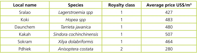
The average prices for main timber species present in the Keo Seima CBPF are listed in Table 7. The products considered are rough boards of various sizes depending on the species: from 5 cm x 15 cm to 12 cm x 25 cm wide and at least 3-5 m long.
Table 7. Average prices of timber in Phnom Penh.
Local name Species Royalty class Average price US$/m3
Sralao Lagerstroemia spp 1 427
The royalties that must be paid to the Cambodian government are based on the commercial classification of each species (US$ 82/m3 for Commercial Class 1). These are measured not on the final product but on
the round logs before processing when these logs reach the second landing. With no processing waste at all, the royalties for Sralao would correspond to 20 percent of the market price. Considering that 1 m3 of
round log can produce 0.6-0.7 m3 of final product, the weight of the royalties on the market price already
increases by 30 percent. Since previous observations of the recovery rate were based on the processing of standing trunk timber to boards, the precise rate from round logs to boards should have been better investigated during the trial harvest.
Cost-benefit analysis of harvesting
Table 8. Breakdown of harvesting costs.
PHI costs Harvesting
costs
Administrative costs
Royalties Market
price
Profit
Sralao, 1 m3 US$ 40 US$ 214 US$ 26 US$ 126 US$ 427 US$ 21
Considering the entire EF area and a 30-year cycle, around 160 ha per year could be harvested (excluding areas such as degraded forest patches, buffers around rivers, biodiversity areas and spiritual forests). Assuming the previously described harvesting quota (using a conservative figure of 4 m3/ha of recovered
timber) and the profit stated above, the CBPF harvesting activities, when carried out at full scale, have a potential income of US$ 13 400/year with royalties paid versus US$94 000/year without royalties. For the trial harvest, a possible income of US$ 6 000 was estimated. It is important to note that the CBPF members would carry out most of the work: inventories, administration and at least some if not all of the timber flow steps. As described above, this could be a problem in terms of human resource availability. However, the work could also be an important extra source of employment for local people and would constitute the majority of local salaries.
Benefit sharing
Carbon market
Carbon inventory
At the time of the general forest inventory, the project team assessed biomass in line with the Verified Carbon Standard (VCS) methodologies.29 The decision to combine the two surveys was particularly
cost-efficient since the requirements for the estimation of the two variables (timber and carbon) were overlapping for the most part, as shown in Table 9. For living trees, the biomass was calculated using allometric equations from the relevant literature.30 Biomass of saplings and bamboo were estimated using
data from the adjacent FA/WCS project in the Core Area of the SPF. The only additional field work necessary was to measure standing dead trees inside the same plots and to carry out a 50 m transect to estimate the lying deadwood.
Lying dead wood yes no 19.3 yes
Saplings yes yes 0.9 no
Bamboo yes yes 0.0 no
After calculations were made, only living trees and lying dead wood provided significant results. The exclusion of dead wood provides a conservative estimate of timber and it simplifies operations without incurring relevant losses in carbon credits.
Feasibility of carbon market
Evans (2013)31 has discussed the options available for CBPF communities in entering the voluntary carbon
credit market while at the same time running the harvesting operations previously described. The procedure involves defining business-as-usual scenarios (baseline), the effect of the project implementation and an estimation of the difference in carbon emissions between the two scenarios. If there is any reduction, that amount of carbon can be sold as credits to voluntary buyers.
For the Keo Seima CBPF, the baseline scenarios included deforestation of the CBPF area for agricultural expansion and illegal logging activities. The project team extrapolated the carbon content of the forest to cover the whole area based on the result of the previously described biomass survey. For the carbon project running in the Core Area of the SPF, the team prepared an empirical spatial model of deforestation based on current observations of deforestation events in the region. The team applied the same model to the CBPF. The team considered high and low levels of deforestation, low and high as different sub-scenarios.
29 See: http://www.v-c-s.org/
30 Chave, J, Andalo, C, Brown, S, Cairns, M A, Chambers, J Q, Eamus, D, Folster, H, Fromard, H, Higuchi, N, Kira, T, Lescure, J P, Nelson,
B W, Ogawa, H, Puig, H, Riera, B and Yamakura, T, 2005, “Tree allometry and improved estimation of carbon stocks and balance in tropical forests.” Oecologia, Vol. 145, pp 87-99.
31 Evans, T, 2013, “WCS report to IGES - Emissions Scenario Modeling for Seima Community-Based Production Forest,” WCS, Cambodia,
The project team scenarios also assumed how the implementation of the CBPF activities would drive the local communities to actively prevent future deforestation and degradation. A reduction of 50 percent for such activities was thus suggested (this figure is a common threshold used for studying the pre-feasibility of carbon-based projects). RIL or the harvesting of less timber than the maximum allowed by Cambodia’s Forestry Law were considered as another potential activity for reducing emissions against business-as-usual harvesting operations in the country.
The results are displayed in Table 10 and they indicate that the implementation of the Keo Seima CBPF will contribute in reducing carbon emissions mainly through the reduction of deforestation. The potential profit was large in the high deforestation sub-scenario and in this situation a carbon credit project could be implemented parallel to CBPF harvesting activities. However, in the low deforestation sub-scenarios, the profit was not significant and likely not enough to cover transaction costs entailed in entering the carbon credit market, such as implementation costs and requirements for community benefit sharing, cash flow and costs related to REDD validation and verification. The RIL modalities are not likely to cause a significant reduction of carbon emission from the business-as-usual scenario and thus do not provide a relevant additional source of income for the CBPF. Reducing the timber harvested significantly decreases carbon emissions in the low deforestation scenario, but the absolute value is still too low.
The project team thus concluded that the potential for the Keo Seima CBPF to join the carbon credit market exists but that it should be studied in more detail to verify which project scenario is able to cover expensive transaction costs and provide a significant source of additional income. Details that need more in-depth studies include: a better assessment of the carbon present in the forest; the deforestation scenario estimated with more accuracy; verification of economic aspects such as transaction costs and price of carbon credit; ownership of carbon revenues; and better clarification of benefit sharing.
Table 10. Summary of carbon market options.
Conclusion
The CBPF Keo Seima project in Cambodia has been trying to implement community-based harvesting operations on a commercial scale – a groundbreaking activity for Southeast Asia. Examples from other regions have shown that this project could deliver the two-fold objective of improving local livelihoods and sustaining forests. The national procedures for the establishment of a community forest were thus engaged together with a request for a trial harvest. Local communities prepared a harvesting plan, but it has not yet been approved or rejected by the Cambodian government. The feasibility of joining the voluntary carbon credit market was also assessed.
The main constraints for local communities to access the timber market in Cambodia are:
• A slow process for recognition of user rights with land conflicts;
• Large areas of well-stocked forest are necessary to ensure the sustainability of operations in the future;
• Difficulties in abiding with the technical requirements of existing forestry policies;
• Methodologies for CFMP preparation, harvesting-plan writing and timber-flow procedures are complicated and costly;
• Royalties are very high; they may be waived for community forests according to the Forestry Law, but the Cambodian government is not keen on this idea; and,
• The carbon credit market could be an additional source of profit under certain conditions.
The project team thus suggests to promote more projects across Cambodia based on the CBPF modality while taking into consideration the following improvements and issues:
• More areas with large and well-stocked forests must be allocated to communities. • Land conflicts with private companies should be solved fairly by the government.
• New technical procedures should be tested for CFMP preparation: introduction of the DBH-Height relationship, testing of smaller rectangular plots or of fixed circular plots (k-tree plots may be too complicated at this stage for local communities) and preparation with FA support of better species-specific volume equations.
• The system in use for forest concession could be considered for community forestry: it includes a low level intensity inventory at the general level to be used for the broader 15 years of planning and a more intense inventory only in the forest area that will be the target of activities in the next five years.
• For the PHI, the project team considers laying out the parallel strip as a necessary step of the work although it comes with a constraint: the impenetrability of the understorey. The constraint could be improved with the use of better tools, such as a range finder to mark a straight line or small chainsaw to cut climbers and vines thus improving efficiency, but these suggestions need to be verified. Another possible way to save time would be to raise the DBH threshold and find a better way of selecting the best candidate trees in the field.
• The harvest trial would have delivered valuable insights and one such activity should happen soon with support from the FA either in Keo Seima CBPF or another site. The project team has always been fully aware that the road to properly preparing communities to run such operations on their own is long and full of obstacles, which only provides further reason for these preparations to begin as soon as possible.
• Simplified timber flow procedures should be tested alongside the ones presently allowed by the FA to identify technical problems and solutions based on their comparisons.
• As a fundamental basis for the implementation of SFM relevant and together with better studies on the annual growth rates, stakeholders must study the silviculture requirements of Cambodian tree species.
• Royalties should be waived for CBPF since most of the income derived from harvesting will be used for the improvement of the socio-economic conditions of the communities.
Annex: List of previous
project reports
Blackett H, 2008, “A study of the Cambodia timber trade: Market analysis for the commercial community forestry project,” Wildlife Conservation Society and Forestry Administration, Phnom Penh, Cambodia.
Evans, T, Thannarak, C, Mesa H, Trey, E, Mohn, B, de Bruyn, T, Bianchi, S, and Dedinas, K, 2011, “Action learning for Community Carbon Accounting in Seima Protection Forest, Cambodia,” Wildlife Conservation Society, Forestry Administration and RECOFTC, Phnom Penh, Cambodia.
Evans, T, Thannarak, C, Mesa H, Trey, E, Mohn, B, de Bruyn, T, Bianchi, S, and Dedinas, K, 2012, “Action learning for Community Carbon Accounting in Seima Protection Forest, Cambodia: Final Report,” Wildlife Conservation Society, Forestry Administration and RECOFTC, Phnom Penh, Cambodia.
Evans, T, 2013, “WCS report to IGES - Emissions Scenario Modelling for Seima Community-Based Production Forest,” WCS, Cambodia, Phnom Penh.
RECOFTC’s mission is to enhance capacities for stronger rights, improved governance and fairer benefits for local people in sustainable forested landscapes in the Asia and the Pacific region.
RECOFTC holds a unique and important place in the world of forestry. It is the only interna-tional not-for-profit organization that special-izes in capacity development for community forestry. RECOFTC engages in strategic net-works and effective partnerships with govern-ments, nongovernmental organizations, civil society, the private sector, local people and re-search and educational institutes throughout the Asia-Pacific region and beyond. With over 25 years of international experience and a dy-namic approach to capacity development – in-volving research and analysis, demonstration sites and training products – RECOFTC delivers innovative solutions for people and forests.
RECOFTC – The Center for People and Forests
P.O. Box 1111 Kasetsart Post Office Bangkok 10903, Thailand Tel (66-2) 940-5700 Fax (66-2) 561-4880 [email protected] www.recoftc.org