MORPHOLOGICAL ASPECTS ON SPRING
APPEARANCE AT GIRIMULYO
AND ITS SURROUNDING AREA, WEST PROGO
Ev. Budiadi, T. Listyani R.A. & Cahyo Utomo Putro
Geological Engineering, Sekolah Tinggi Teknologi Nasional YogyakartaBabarsari Street No.1 Depok, Sleman, D.I.Yogyakarta, Indonesia [email protected]
Abstrak
Salah satu aspek yang dapat mengontrol pemunculan airtanah adalah geomorfologi daerah setempat. Penelitian tentang mataair dilakukan melalui survei geologi airtanah secara langsung di lapangan dengan penekanan pada aspek geomorfologi. Tujuan penelitian adalah untuk mengetahui kontrol geomorfologi di daerah penelitian terhadap pemunculan mataair. Lokasi penelitian adalah daerah Girimulyo dan sekitarnya, khususnya yang termasuk dalam Kubah Kulon Progo, yang termasuk dalam Kecamatan Girimulyo, Kabupaten Kulon Progo. Penelitian ini dilakukan dengan metode survei geomorfologi dengan melakukan pendataan bentang alam yang meliputi lereng, elevasi dan karakteristik mataair secara langsung di lapangan. Hasil survei menunjukkan bahwa beberapa mataair merupakan mataair depresi dimana pemunculannya dikontrol oleh morfologi/topografi, sebagai contoh yaitu mataair Semurup dan Njuboh. Beberapa mataair kontak juga dijumpai di daerah penelitian, dimana mataair jenis ini tidak selalu dikontrol oleh morfologi daerah setempat, walaupun kadang-kadang berada di suatu lereng yang cukup terjal. Dengan demikian, hubungan lereng dan elevasi tidak selalu signifikan terhadap pemunculan mataair.
Kata kunci: geomorfologi, mataair, tekuk lereng
Abstract
One of geological aspects which control on spring appearance may be local geomorphology. Research on springs is done through groundwater geological surveys directly in the field with emphasis on geomorphological aspects. The purpose of this research is to know the geomorphological control to spring appearance in the research area. The research location is Girimulyo and surrounding areas, especially those included in the West Progo Dome, which is included in Girimulyo District, West Progo Regency. This research was conducted by geomorphological survey method by performing landscape data collection which includes slope, elevation and spring characteristics directly in the field. Survey results show that some springs are depression springs where their appearance is
The hilly areas of West Progo are part of the South Serayu Mountain physiography dome in the central depression zone [1]. Dome physiography is known as an area that has a landscape with a fairly coarse relief with steep to very steep slope, strong dissected topography with relatively hard and compact rocks. The geologic structure is quite intensive developing in this area. The landscape and drainage look under varying conditions, at both high and low terrain. The various stream conditions will be examined in this study. The potential for water is also of particular concern in this study considering many areas in West Progo which include hard water areas.
The research primarily wants to know the relationship between local geomorphology and spring occurrence. Geomorphological aspects will become very important for the community so that they can understand the local water conditions. Surface and subsurface flows (if any) are also an important study for the community so that they can independently meet the water needs that are essential to everyday life.
for example because of quite sharp of the break of slope is to cut the flow of local groundwater. This study needs to be developed by looking at the characteristics of each water found in Girimulyo area.
The areas studied is included in Girimulyo District, West Progo Regency (Figure 1). This district has several villages, including Banjarsari, Jatimulyo, Gerbosari, Kebonharjo, Ngargosari, Pagerharjo. Astronomically, Girimulyo area is located at the coordinates 07⁰40 '10 " - 07⁰47'43" latitude and 110⁰2'20.4"- 110⁰8'10.56'' longitude located in the west of Yogyakarta Province.
Figure 1. Location of research area shown in topographic map. 2. Methods
Geomorphological survey was conducted in the field by geologic description, especially at the locations of the springs. Hydrogeological surveys were carried out using standard geological equipment (hammer, compass, loupe) and equipped with an water gauge (meter, bucket, and stopwatch). Observations were made on the morphology as well as the springs and aquifer conditions in the studied area. Elevation, slope, petrophysic of aquifer and spring discharge data were analyzed to see the morphological association with the occurrence of springs in the study area.
3. Geological of Girimulyo Area
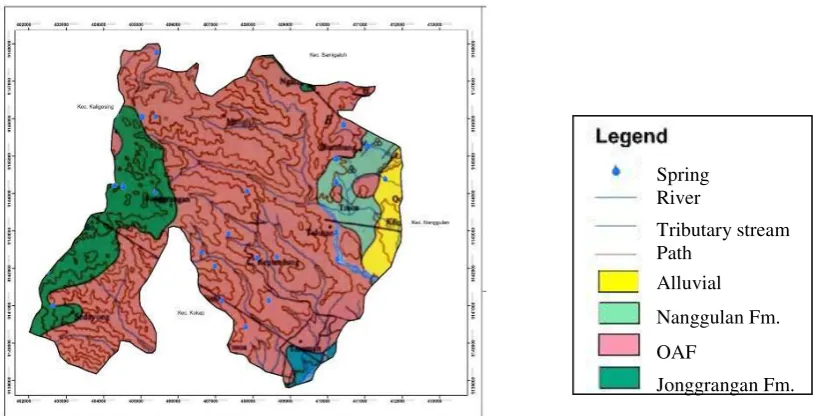
The geology of the research area is largely composed by Tertiary rocks that are part of the West Progo Hills stratigraphy. The rocks included in the West Progo Hills stratigraphy exposed in the study area are Nanggulan, Old Andesite and Jonggrangan Formations [2] (Figure 2).
Figure 2. Geological map of research area [2].
Spring River
Tributary stream Path
Alluvial Nanggulan Fm. OAF
Nanggulan Formation revealed in the research area include claystone, sandstone and marl. Claystone seems to be grayish brown, clastic texture, layered or massive, which is composed by clay mineral composition with some siliciclastic impurity minerals such as opaque minerals. Sandy sandstone shows clastic texture, fine - medium grain sizes, layered or laminated structures, with plagioclase, quartz, opaque minerals, sometimes containing mollusk fossils compositions. Marl is found in several places with the appearance of yellowish brown color, clastic texture, layered - laminate structure, with plagioclase, opaque minerals, and carbonate minerals compositions (Fig. 3).
.
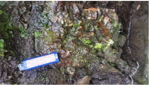
Figure 3. Claystone of Nanggulan Formation found at Ngroto spring.
Jonggrangan Formation is composed of limestone and carbonate sandstones. The carbonate sandstones show the weathered color of brown, the brightest color of bright gray, clastic texture, bedded structure (N210°E), medium sand grain size, with lithic and mollusc shell composition. The uncovered limestone consists of reef (non-clastic) limestone as well as a clastic limestone that is often structurally coated. The limestone exhibits a brown - brownish gray colored, non-clastic texture, massive structure, with carbonate composition (Fig. 4). Many rocks from Jonggrangan Formation have become soil with blackish brown color.
Figure 4. One of the features of Jonggrangan limestone found at Jarakan, Kebonharjo.
The Old Andesite Formation is composed by andesite breccia. Andesite breccia is generally dark brown, epiclastic or pyroclastic structure. Weathered andesite fragments have dark brown color, or gray fresh colors, pyroclastic texture, massive structure, composed by pyroxene, biotite, plagioclase, feldspar, a few quartz. Andesite breccia matrix is in the form of dark gray sand. Some rock outcrops have weathered and turned into soil.
surrounding areas. The condition of lithology as a whole experiences a moderate to high degree of weathering. High levels of weathering are found in andesite breccia, tuff breccia, and reef limestone units, while moderate weathering rates are mainly found in andesite intrusion units.
The Old Andesite Formation composed by breccias with fragments of andesite, lapilli tuff, tuff, lapilli breccia, agglomerate, lava flows and volcanic sandstone, with Oligocene-Miocene age. While the Jonggrangan Formation is lied unconformably on the Old Andesite Formation. This formation is Miocene. The lithology of this formation consists of conglomerates, sandy marl, tuffaceous marl, limestone with bedded structures and coral limestone with intercalation of lignite.
4. Result and Discussion
4.1. Morphology
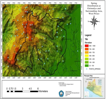
The morphology of the research area is largely a rough relief area, forming a fairly steep until very steep hill, especially in the middle to west of the research area. The eastern region is relatively more sloping, with undulating to rolling morphologies. There are some springs distribute in the research area (Fig. 5).
Figure 5. Springs distribution map at Girimulyo and surrounding area.
The district of Girimulyo and its suburbs can be divided into 3 units [3], [4]. Genetically these geomorphological units can generally be divided into denudational structural and karst geomorphological units.
Spring Distribution at Girimulyo and Surrounding Area,
4.1.1. Rolling – Hilly Karst Unit
This unit is located on the southeast with an area of 4.6 km2 or 19.1% of the entire study area. The location of this unit is located in Jatimulyo Village, on west side is bordered by Kalilu Hamlet and east by Beteng Hamlet. The northern boundary is limited by the Sibolong Hamlet and the southern boundary is limited by the Ngesong Hamlet. This unit has a slope of 15o - 20o with a large slope value that is affected by the topography of each different region. The height varies to 123 m, between 616 m and 739 m elevations.
4.1.2. Steeply Slope Karst Cone Unit
This unit is composed of a steeply sloped karst cone with a relatively pointed tip, located in the central and northern regions of this unit with an area of 0.6 km2 or 2.9% of the entire study area. The location of this unit is located on Mt. Ngesong, Mt. Krengseng, Mt. Sibolong and Mt. Kedung. This unit has a 30o-50o slope with a large slope value that is affected by the topography of each slightly different area. The existing high difference reaches 162.5 m, between the elevation of 650 m and 812.5 m.
4.1.3. Denudational Structural Hilly Unit
This unit is composed of structural hills of medium to steep slopes that extend to the middle and east of this unit with an area of 10.8 km2 or 50.9% of the entire study area. The location of this unit to the west is bordered by Banyunganti Village, north by Seblereng Hamlet, east by Karanggede Village and south by Tanggulangin. This unit has an average slope of 15º-50º.
The hills of West Progo are dominated by high enough hills with high dissected topography. The steep hills that exist in the research area are generally built by volcanic rocks from the Old Andesite Formation with high resistance. Limestone with lower resistance is sometimes encountered as a thin layer that covers over the rocks of the Andesite Andesite Formation.
Some of the valleys that are slightly flat to undulating are found in a relatively small area between the hills in the West Progo Hills. In the river valleys or small grooves, sometimes encountered seepage of the springs despite small debris.
Areas that have a moderate or slightly steep slope generally form a rolling morphology on the hillsides. Locally there are also occasional steep slopes in the valley on either side of the river. The river flow develops as a result of erosion of rill, gully, ravine to form river at downstream / lowland area. 4.2. Spring Condition
The formation of a spring is a thing to be known in order to evaluate the quantity, quality and continuity of the flow of water coming out of the spring. Groundwater flow systems and hydrogeological systems in a spring show the genesis of springs, thus both of them are very influential on the condition of the spring. Classification of springs is grouped according to their various characteristics as well as in the process of their formation or genesis, so that in nature there are various names in the existing springs, depending on the basis of grouping [5].
Figure 4 shows the location of the waters found in the study area. There are more than 20 springs in the study area included in Girimulyo Subdistrict. In this research, there are some examples, 5 (five) springs that have big enough discharge (> 1 liter / second), i.e. Ngolo, Gopas, Njuboh, Salamrejo and Semurup springs.
The condition of the springs can not be separated from the hydrogeological characteristics of the research area. The study area is included in the hydrogeological map of Pekalongan Sheet [5] (Figure 6). According to the map, the study area has the characteristics of rare groundwater areas and areas with low productivity aquifers. Areas with less productive aquifers are usually only beneficial to the surrounding community whose location is adjacent to the springs. The area of the hydrogeological unit is mainly supported by both the andesite breccia and the limestone aquifer.
4.2.1. Ngolo Spring
Figure 6. Hydrogeological map of Girimulyo [5].
From the side of the constituent rocks, Ngolo spring is included in the category of fractured spring whose groundwater comes out of rocks exposed to geologic structures such as joints and cracks (Fig. 7). On the other hand, based on the cause of the occurrence (genesis) of the spring, the Ngolo spring falls into the category of gravitational springs or contact type. Named contact because of the existence of this spring itself formed due to the contact of the rock with the difference permeability, between the Jonggrangan limestone and andesite breccia of Old Andesite Formation.
Figure 7. Ngolo spring at Jatimulyo Village, Girimulyo District. 4.2.2. Gopas Spring
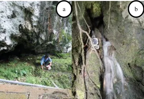
In line with Ngolo spring, the spring appears due to two lithologies with different permeability, between the andesite breccia (impermeable) and limestone (permeable). While from the petrophysical side of the aquifer, it is known as a tubular spring (cave spring), because this spring out of the fractures from limestone solution.
Figure 8. Reef limestone found at surroundings of spring (a). Cracks or holes as dissolved outlet of springs (b).
4.2.3. Njuboh Spring
Based on information of local residents, Njuboh spring is a spring that has the better quality in West Progo Regency. Quantity discharge of the spring is relatively small, but its continuity is relatively good so that by the surrounding community with the help of NGO, it has built a good water drainage installation. Njuboh spring flows throughout the season, but there is fluctuation in discharge at the turn of the season. The aquifer of this spring is sedimentary rocks of sandstone, so it is a type of porous aquifer spring.
The genesis of this spring is the gravitational springs of depression. Because the spring is relatively located in the bend of the slope (break of slope) so that the existence of these springs formed due to groundwater table cutting by topography. This type of spring is very unstable; the quantity and quality of the groundwater emitted depends heavily on the circumstances surrounding it, especially its dependence on precipitation and the ease of contamination by human activities. Depression spring generally has a short groundwater flow path and a relatively young water age, and is classified as a local groundwater flow system [6].
4.2.4. Salamrejo Spring
One more bigger spring and by the people also empowered for their needs is the Salamrejo spring that has considerable discharge (5 liters / sec). According to the explanation from the community, this spring was formerly a dead banyan tree root, and there are several sources of fractures that join into the river. This springs discharge is also relatively volatile at the turn of the season, but still drains enough water for the needs of the surrounding community.
The genesis of these springs is related to the recrust of acyclic roots from the tree roots that penetrate the local aquifer, and may not occur from a artesis or confined aquifer. Petrophysic aquifer of spring is a limestone of the local Jonggrangan Formation, with a visible structure of lapies morphology of dissolving carbonate rocks.
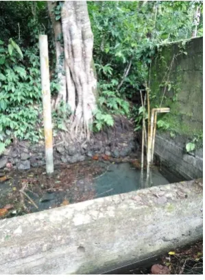
4.2.5. Semurup Spring
The existence of this spring is relatively easy to find because it is right on the edge of the road (Figure 9). This type of spring is a fractured spring, where the fractures formed are not due to geological structures, but rather because of biological factors. That is the presence of banyan trees whose roots infiltrate the aquifer rocks so that the fractures form. Apart from that, the environmental factor, especially the existence of trees is commonly known to support the balance of the hydrological cycle.
In terms of genesis, Semurup spring is classified into gravitational type depression springs. Depression springs are classified as local springs because their quality and quantity is strongly influenced
by rainfall and the surrounding environment. Generally this type of spring is very volatile because of its nature is also a shallow groundwater.
Figure 9. Semurup spring.
Table 2 shows the watershed condition described above with the description of the discharge. The classification of the discharge is based on the Meinzer classification (1923) in [7].
Table 2. Springs in research area and their discharge rate class.
No Spring Discharge Rate (l/s) Meinzer Class Health Ministry Class (2002)
1 Ngolo 10.3 IV High
2 Gopas 4.5 V Medium
3 Njuboh 1 V Small
4 Salamrejo 5 V Medium
5 Semurup 3.12 V Medium
4.3. Morphological Control on Spring
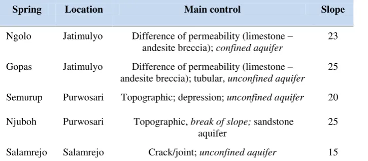
The springs in the study area are generally gravitational type. The type of springs are contact or depression springs (Table 3).
Table 3. Spring types in research area.
Spring Location Aquifer Spring Type
Ngolo Jatimulyo Reef limestone of Jonggrangan Fm. Gravity, contact Gopas Jatimulyo Reef limestone of Jonggrangan Fm. Gravity, contact Semurup Purwosari Andesite breccia of Old Andesite
Fm.
Gravity, contact
Njuboh Purwosari Reef limestone of Jonggrangan Fm. Gravity, contact Salamrejo Salamrejo Andesite breccia of Old Andesite
Fm.
Several springs found in the research area are supported by morphological aspects of break of slope. The existence of cutting groundwater flow by topography generally produces depression type springs. Several topographically controlled springs can be seen in Table 4, such as Semurup and Njuboh springs.
Some springs are controlled by the topography of slopes thus the appearance of these springs are related to the morphology of the local area, for example Ngolo and Gopas springs. However, depression springs are not always controlled by steep slopes. Some springs in the study area are contact springs that are not related to the morphology of the area. The steep slopes at where the emergence of the springs are not necessarily the main genetic factors of these springs. Contact springs may arise from the aquifer, either confined or free.
Several springs in the study area were controlled by the topography of the slope. These springs appear to be controlled by local morphology. In addition, there are some springs that are contact spring. Contact springs are generally unrelated to morphology. Therefore, local topographic controls apply to some springs. The contact springs are generally controlled by different types of rocks or because of the difference in permeability between the soil and rocks. AT some areas, geomorphological aspects usually control on springs occurrence, there is no exception even in geothermal area [8].
Table 4. Geological control of spring occurrence in research area.
Spring Location Main control Slope
Ngolo Jatimulyo Difference of permeability (limestone – andesite breccia); confined aquifer
23
Gopas Jatimulyo Difference of permeability (limestone – andesite breccia); tubular, unconfined aquifer
25
Semurup Purwosari Topographic; depression; unconfined aquifer 20 Njuboh Purwosari Topographic, break of slope; sandstone
aquifer
25
Salamrejo Salamrejo Crack/joint; unconfined aquifer 15
5. Conclusion
The morphology of the research area generally has a coarse relief, with the landscape of steep to very steep cliffs. There is still gently sloping morphology that can be found in the east. The springs appear on the slopes with break of slopes morphology or at the foot of the hill. In addition, springs can also be found around the river flow. Some springs controlled by slope topography and associated with morphology. Some springs develop as depression springs, which occur as a result of groundwater cutting by topography. Usually this spring formed at the bottom of the quite steep cliff. Some springs are contact springs, showing no relation to morphology, though occasionally appearing on steep slopes. Rocks usually control the occurrence of springs caused by different permeabilities. Contact spring is not always affected by topography. Therefore, the slope and elevation relationships are not necessarily significant to the appearance of the springs.
Reference
[1] Van Bemmelen, R.W., 1949, The Geology of Indonesia, Vol. 1A, Martinus Nijhoff, The Hague, Netherland.
[3] Van Zuidam , R.A. and Van Zuidam F.I.- Cancelado, 1979, Terrain Analysis an Classification using Aerial Photographs, Textbook VII-6, ITC, Netherland.
[4] Van Zuidam, R.A., 1983, Guide to Geomorphologic Aerial Photographic Interpretation & Mapping, Section of Geology and Geomorphology, ITC, Enschede, The Netherlands.
[5] Effendi, A.T., 1985, Hydrogeological Map of Pekalongan Sheet, Scale 1 : 250.000, Geological Environmental Directorate, Bandung.
[6] Hendrayana, H., 2013, Basics of Hydrogeology, Geological Engineering Department, Faculty of Engineering, Gadjah Mada University, Yogyakarta.
[7] Kresic N. & Stevanovic Z., 2010, Groundwater Hydrology of Springs. Engineering, Theory, Management, and Sustainability, Elsevier Inc., USA.
![Figure 6. Hydrogeological map of Girimulyo [5].](https://thumb-ap.123doks.com/thumbv2/123dok/2330348.1634340/6.595.205.381.486.618/figure-hydrogeological-map-of-girimulyo.webp)