i
Approval Date: 2013-01-18 Posted Date: 2012-12-07 Publication Date: 2013-03-26
Reference number of this document: OGC 12-097
OGC URI: http://www.opengis.net/def/doc-type/per/OWS-9-bulk-data-transfer-gml
Category: Public Engineering Report
Editor(s): Jeff Harrison
OGC
®OWS-9 Engineering Report - SSI - Bulk Data Transfer
(GML Streaming)
Copyright © 2013 Open Geospatial Consortium.
To obtain additional rights of use, visit http://www.opengeospatial.org/legal/.
Warning
This document is not an OGC Standard. This document is an OGC Public
Engineering Report created as a deliverable in an OGC Interoperability Initiative and is not an official position of the OGC membership. It is distributed for review and comment. It is subject to change without notice and may not be referred to as an OGC Standard. Further, any OGC Engineering Report should not be referenced as required or mandatory technology in procurements.
Document type: OGC® Engineering Report
Document subtype: NA
Document stage: Approved for public release
ii Copyright © 2013 Open Geospatial Consortium
Abstract
This document provides a description of the Bulk Data Transfer investigations related to Geography Markup Language (GML) streaming and feature data transportation
implemented in the OGC OWS-9 test bed.
This document extends the concept of Bulk Data Transfer to the dissemination of large payloads consisting of geospatial data sets and/or collections of data sets between machines that are connected via a network.
This document also describes the delivery of large payloads consisting of geospatial data sets and/or collections of data sets to SpatiaLite/SQLite to store the data for use by mobile applications.
Keywords
ogcdoc, ows9, ows-9, bulk data transfer, gml
What is OGC Web Services 9 (OWS-9)?
OWS-9 builds on the outcomes of prior OGC interoperability initiatives and is organized around the following threads:
- Aviation: Develop and demonstrate the use of the Aeronautical Information Exchange Model (AIXM) and the Weather Exchange Model (WXXM) in an OGC Web Services environment, focusing on support for several Single European Sky ATM Research (SESAR) project requirements as well as FAA (US Federal Aviation Administration) Aeronautical Information Management (AIM) and Aircraft Access to SWIM (System Wide Information Management) (AAtS) requirements.
- Cross-Community Interoperability (CCI): Build on the CCI work accomplished in OWS–8 by increasing interoperability within communities sharing geospatial data, focusing on semantic mediation, query results delivery, data provenance and quality and Single Point of Entry Global Gazetteer.
- Security and Services Interoperability (SSI): Investigate 5 main activities: Security Management, OGC Geography Markup Language (GML) Encoding Standard
Application Schema UGAS (UML to GML Application Schema) Updates, Web Services Façade, Reference Architecture Profiling, and Bulk Data Transfer.
iii - Compliance & Interoperability Testing & Evaluation (CITE): Develop a suite of compliance test scripts for testing and validation of products with interfaces
implementing the following OGC standards: Web Map Service (WMS) 1.3 Interface Standard, Web Feature Service (WFS) 2.0 Interface Standard, Geography Markup Language (GML) 3.2.1 Encoding Standard, OWS Context 1.0 (candidate encoding standard), Sensor Web Enablement (SWE) standards, Web Coverage Service for Earth Observation (WCS-EO) 1.0 Interface Standard, and TEAM (Test, Evaluation, And Measurement) Engine Capabilities.
iv Copyright © 2013 Open Geospatial Consortium
License Agreement
Permission is hereby granted by the Open Geospatial Consortium, ("Licensor"), free of charge and subject to the terms set forth below, to any person obtaining a copy of this Intellectual Property and any associated documentation, to deal in the Intellectual Property without restriction (except as set forth below), including without limitation the rights to implement, use, copy, modify, merge, publish, distribute, and/or sublicense copies of the Intellectual Property, and to permit persons to whom the Intellectual Property is furnished to do so, provided that all copyright notices on the intellectual property are retained intact and that each person to whom the Intellectual Property is furnished agrees to the terms of this Agreement.
If you modify the Intellectual Property, all copies of the modified Intellectual Property must include, in addition to the above copyright notice, a notice that the Intellectual Property includes modifications that have not been approved or adopted by LICENSOR.
THIS LICENSE IS A COPYRIGHT LICENSE ONLY, AND DOES NOT CONVEY ANY RIGHTS UNDER ANY PATENTS THAT MAY BE IN FORCE ANYWHERE IN THE WORLD.
THE INTELLECTUAL PROPERTY IS PROVIDED "AS IS", WITHOUT WARRANTY OF ANY KIND, EXPRESS OR IMPLIED, INCLUDING BUT NOT LIMITED TO THE WARRANTIES OF MERCHANTABILITY, FITNESS FOR A PARTICULAR PURPOSE, AND NONINFRINGEMENT OF THIRD PARTY RIGHTS. THE COPYRIGHT HOLDER OR HOLDERS INCLUDED IN THIS NOTICE DO NOT WARRANT THAT THE FUNCTIONS CONTAINED IN THE INTELLECTUAL PROPERTY WILL MEET YOUR REQUIREMENTS OR THAT THE OPERATION OF THE INTELLECTUAL PROPERTY WILL BE
UNINTERRUPTED OR ERROR FREE. ANY USE OF THE INTELLECTUAL PROPERTY SHALL BE MADE ENTIRELY AT THE USER’S OWN RISK. IN NO EVENT SHALL THE COPYRIGHT HOLDER OR ANY CONTRIBUTOR OF
INTELLECTUAL PROPERTY RIGHTS TO THE INTELLECTUAL PROPERTY BE LIABLE FOR ANY CLAIM, OR ANY DIRECT, SPECIAL, INDIRECT OR CONSEQUENTIAL DAMAGES, OR ANY DAMAGES WHATSOEVER RESULTING FROM ANY ALLEGED INFRINGEMENT OR ANY LOSS OF USE, DATA OR PROFITS, WHETHER IN AN ACTION OF CONTRACT, NEGLIGENCE OR UNDER ANY OTHER LEGAL THEORY, ARISING OUT OF OR IN CONNECTION WITH THE IMPLEMENTATION, USE, COMMERCIALIZATION OR PERFORMANCE OF THIS INTELLECTUAL PROPERTY.
This license is effective until terminated. You may terminate it at any time by destroying the Intellectual Property together with all copies in any form. The license will also terminate if you fail to comply with any term or condition of this Agreement. Except as provided in the following sentence, no such termination of this license shall require the termination of any third party end-user sublicense to the Intellectual Property which is in force as of the date of notice of such termination. In addition, should the Intellectual Property, or the operation of the Intellectual Property, infringe, or in LICENSOR’s sole opinion be likely to infringe, any patent, copyright, trademark or other right of a third party, you agree that LICENSOR, in its sole discretion, may terminate this license without any compensation or liability to you, your licensees or any other party. You agree upon termination of any kind to destroy or cause to be destroyed the Intellectual Property together with all copies in any form, whether held by you or by any third party.
Except as contained in this notice, the name of LICENSOR or of any other holder of a copyright in all or part of the Intellectual Property shall not be used in advertising or otherwise to promote the sale, use or other dealings in this Intellectual Property without prior written authorization of LICENSOR or such copyright holder. LICENSOR is and shall at all times be the sole entity that may authorize you or any third party to use certification marks, trademarks or other special designations to indicate compliance with any LICENSOR standards or specifications.
This Agreement is governed by the laws of the Commonwealth of Massachusetts. The application to this Agreement of the United Nations Convention on Contracts for the International Sale of Goods is hereby expressly excluded. In the event any provision of this Agreement shall be deemed unenforceable, void or invalid, such provision shall be modified so as to make it valid and enforceable, and as so modified the entire Agreement shall remain in full force and effect. No decision, action or inaction by LICENSOR shall be construed to be a waiver of any rights or remedies available to it.
v
Contents
Page1 Introduction ... 7
1.1 Scope ... 7
1.2 Document contributor contact points ... 8
1.3 Revision history ... 8
1.4 Future work ... 8
1.5 Forward ... 9
2 References ... 9
3 Terms and definitions ... 9
4 Conventions ... 11
4.1 Abbreviated terms ... 11
4.2 UML notation ... 12
5 Bulk Data Transfer using Streaming ... 12
6 Basic Workflow for Streaming GML ... 13
7 Testing the Basic Workflow for Streaming GML ... 14
7.1 Service Description Handling ... 16
7.2 Data Access Testing ... 16
7.3 Testing Access with OGC Mobile Client Applications ... 20
7.4 Transaction Handling in the Basic Workflow for Streaming GML ... 21
7.5 Other Client Applications ... 21
8 SQLite/SpatiaLite Workflow for GML Streaming ... 22
8.1 SQLite/SpatiaLite and GeoPackage Overview ... 23
8.2 Creating GeoPackage from WFS ... 24
8.3 Using GeoPackage for Connected/Disconnected Mobile Apps ... 27
6 Copyright © 2013 Open Geospatial Consortium
Figures
PageFigure 1 – Basic operation sequence for GML retrieval using streaming from WFS ... 14
Figure 2 – OSM test data over Haiti as GML in Gaia ... 16
Figure 3 - GML streaming to the Gaia application during testing ... 18
Figure 4 - GML Streaming to a Field User on The Carbon Project Android app ... 20
Figure 5 - GML Streaming accessed by Lockheed Martin application ... 22
Figure 6 - Creating a GeoPackage from Streaming GML ... 25
Figure 7 - GeoPackage mobile app on Android ... 28
7 Copyright © 2013 Open Geospatial Consortium
OGC
®OWS-9 Engineering Report - SSI - Bulk Data Transfer
(GML Streaming)
1 Introduction
1.1 Scope
This document provides a description of the Bulk Data Transfer investigations related to Geography Markup Language (GML) streaming and feature data transportation
implemented in the OGC OWS-9 test bed.
This document builds on work conducted in the OGC OWS-8 test bed, where methods for distributing geospatial data sets and/or collections of data sets between machines that may or may not be connected via a network were developed. This approach defined a container format that is ZIP compressed and contains feature data, feature schema and topology encoded using GML and metadata encoded using ISO19115.
This document extends the concept of Bulk Data Transfer to the dissemination of large payloads consisting of geospatial data sets and/or collections of data sets between machines that are connected via a network. Specifically, the approach investigated is designed for scenarios where a geospatial data producer wants to write large amounts of GML data directly (either synchronously or asynchronously) to a stream which can be read by a client application. Streaming services described in this document currently implement the OGC Web Feature Service (WFS) standard with digital data payload format as GML.
Geospatial data sets and/or collections of geospatial data sets described in this document are geographic features. A feature is an abstraction of real world phenomena. A
geographic feature is a feature associated with a location relative to the Earth, and a digital representation of the real world encoded as a GML document.
8 Spatial SQL capabilities. SQLite is a software library that implements a self-contained, serverless, transactional SQL database engine. SpatiaLite implementations described in this document implement the draft GeoPackage specification. GeoPackage is an open, non-proprietary, platform-independent GeoPackage container for distribution and direct use of all kinds of geospatial data.
1.2 Document contributor contact points
All questions regarding this document should be directed to the editor or the contributors:
Name Organization
Jeff Harrison The Carbon Project Mark Mattson The Carbon Project Adam Lloyd Lockheed Martin
1.3 Revision history
Date Release Editor Primary clauses modified
Description 2012-12-05 0.0.1 Harrison All New draft document
2012-12-07 0.0.5 Harrison All Draft document was edited throughout with contributions from Messrs. Mattson and Lloyd
1.4 Future work
Improvements in this document are desirable to assess additional methods to disseminate large geospatial data sets and/or collections of data sets between machines
9 Copyright © 2013 Open Geospatial Consortium
API enhancements to provide low latency access to real-time streams of rapidly updated feature data may also be investigated. Such implementations may include a streaming client able to access pushed messages without polling a service endpoint. In addition, the use of W3C Server-Sent Events may be investigated.
1.5 Forward
Attention is drawn to the possibility that some of the elements of this document may be the subject of patent rights. The Open Geospatial Consortium shall not be held
responsible for identifying any or all such patent rights.
Recipients of this document are requested to submit, with their comments, notification of any relevant patent claims or other intellectual property rights of which they may be aware that might be infringed by any implementation of the standard set forth in this document, and to provide supporting documentation.
2 References
The following documents are referenced in this document. For dated references, subsequent amendments to, or revisions of, any of these publications do not apply. For undated references, the latest edition of the normative document referred to applies.
OGC 09-025r1, OpenGIS Web Feature Service 2.0 Interface Standard (also ISO 19142)
OGC 09-026r1, OpenGIS Filter Encoding 2.0 Encoding Standard
OGC 10-100r3, Geography Markup Language (GML) simple features profile
OGC 06-121r3, OGC® Web Services Common Standard
OGC 12-128r1 GeoPackage Implementation Specification (Draft)
3 Terms and definitions
10
Attribute - 〈〈XML〉〉 name-value pair contained in an element
[ISO 19136:2007, definition 4.1.3]
Client application - software component that can invoke an operation from a server
[ISO 19128:2005, definition 4.1]
Coordinate - one of a sequence of n numbers designating the position of a point in n -dimensional space
[ISO 19111:2007, definition 4.5]
Coordinate reference system - coordinate system that is related to an object by a datum [ISO 19111:2007, definition 4.8]
Coordinate system - set of mathematical rules for specifying how coordinates are to be assigned to points
[ISO 19111:2007, definition 4.10]
Element - 〈XML〉 basic information item of an XML document containing child elements, attributes and character data
[ISO 19136:2007, definition 4.1.23]
Feature - abstraction of real world phenomena [ISO 19101:2002, definition 4.11]
NOTE: A feature can occur as a type or an instance. It is intended that the term “feature type” or “feature instance” be used when only one is meant.
Filter capabilities XML - metadata, encoded in XML that describes which predicates
defined in this International Standard a system implements
Filter expression - predicate expressionencoded using XML
Interface - named set of operations that characterize the behavior of an entity [ISO 19119:2005, definition 4.2]
Namespace - 〈XML〉 collection of names, identified by a URI reference which are used in XML documents as element names and attribute names [W3C XML Namespaces]
Operation - specification of a transformation or query that an object may be called to execute
11 Copyright © 2013 Open Geospatial Consortium
Property - facet or attribute of an object referenced by a name
Request - invocation of an operation by a client
[ISO 19128:2005, definition 4.10]
Response - result of an operation returned from a server to a client
[ISO 19128:2005, definition 4.11]
Service - distinct part of the functionality that is provided by an entity through interfaces
[ISO 19119:2005, definition 4.1]
Server - particular instance of a service
[ISO 19128:2005, definition 4.12]
Uniform Resource Identifier URI - unique identifier for a resource, structured in conformance with IETF RFC 2396
[ISO 19136:2007, definition 4.1.65]
4 Conventions
4.1 Abbreviated terms
API Application Program Interface
COTS Commercial off The Shelf
CRS Coordinate Reference System
ER Engineering Report
FES Filter Encoding Standard
GML Geography Markup Language
GMLSF Simple Feature Geography Markup Language
HTTP Hypertext Transfer Protocol
KVP Keyword-Value Pair
MIME Multipurpose Internet Mail Extensions
12
TDS Topographic Data Store
UML Unified Modeling Language
WFS Web Feature Service
XML Extensible Markup Language
4.2 UML notation
Most diagrams that appear in this standard are presented using the Unified Modeling Language (UML) static structure diagram, as described in Subclause 5.2 of [OGC 06-121r3].
5 Bulk Data Transfer using Streaming
OGC Web Services (OWS), including GML services such as the OGC Web Feature Service, define interfaces for data access and update operations using HTTP as the distributed computing platform. Clients interact with OWS by submitting Requests and getting Responses from Services. However, underlying this approach there may be limitations for Services and Clients. As an example, a WFS implementation may construct FeatureCollection responses by buffering them into memory, and the size will depend on the system configuration and memory allocated. In other words, there may be a limit on the size of returned data since the entire content of a message is present in memory before it is sent. While this is a good strategy for many scenarios, large
messages, such as GML data set for an entire country, could exhaust a system's resources.
In OWS-9 integration and testing strategy to deal with such large payloads was
streaming. This strategy acknowledges that while messages, especially those expressed in XML (GML), are traditionally thought of as being relatively compact data packages, a message might be multiple gigabytes in size and resemble a continuous data stream more than a data package. In fact, implementers of services that deliver GML have seen this behavior many times in ‘real world’ work implementing OGC-based systems. Therefore this thread of OWS-9 investigated methods for requesting data transferred in a ‘streaming mode’ instead of a ‘buffered mode’.
13 Copyright © 2013 Open Geospatial Consortium
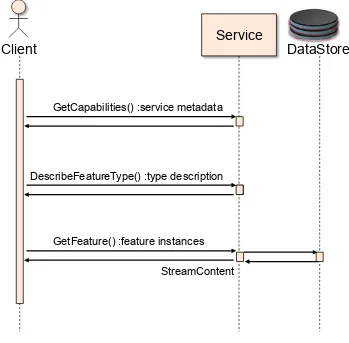
6 Basic Workflow for Streaming GML
The streaming approach may be used in WFS serving a set of features encoded as GML. As part of this project a cloud-based WFS was established by The Carbon Project to support testing this ‘FeatureSource’ workflow. Figure 1 and the following descriptions illustrate the sequence of operation calls to obtain GML as streamed data from a datastore across the WFS interface.
1. A client application would request a capabilities document from the WFS supporting streaming. Such a document contains a description of the operations that the WFS supports and a list of the feature types that the service offers. 2. A client application (optionally) makes a request to a web feature service for the
definition of one or more of the feature types that the WFS supporting streaming can service using the DescribeFeatureType operation.
3. Based on the definition of the FeatureType the client application generates a request as specified in the OGC WFS interface. The WFS is invoked to read and service the request
4. A response document containing zero or more features is generated by writing directly (either synchronously or asynchronously) to a stream on the server implementation software. The stream is read by a client application.
The streaming approach used in OWS-9 for Bulk Data Transfer was implemented as a server-side design choice. This approach has the advantage of increasing the performance of GML delivery while requiring no modifications to existing client applications since the required functionality is ‘wrapped’ in a WFS interface.. This design choice was selected to provide lower the bar for implementation of higher performance architectures to deliver large amounts of GML to requesting client applications.
14 In this workflow the BBOX Spatial Operator was calculated as each record is read in. This was done because the BBOX isn't known at first – so as the features get streamed out, the BBOX gets built. The result of this approach is that the BBOX appears after the features in the result set. Typically, it is before the features in a GML document.
Service
Client
GetCapabilities() :service metadata
DescribeFeatureType() :type description
GetFeature() :feature instances
DataStore
StreamContent
Figure 1 – Basic operation sequence for GML retrieval using streaming from WFS
The streaming approach used in OWS-9 for Bulk Data Transfer was tested in multiple client application configurations as described in the following sections.
7 Testing the Basic Workflow for Streaming GML
15 Copyright © 2013 Open Geospatial Consortium
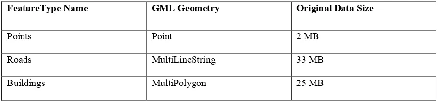
Dominican Republic on the Microsoft Azure Cloud. OpenStreetMap data representing the following features was obtained as Shapefiles, FeatureTypes were created and data was imported into the test service on the Microsoft Azure Cloud:
Table 1 – OpenStreetMap test data for GML Streaming
FeatureType Name GML Geometry Original Data Size
Points Point 2 MB
Roads MultiLineString 33 MB
Buildings MultiPolygon 25 MB
16
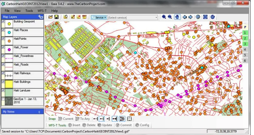
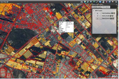
Figure 2 – OSM test data over Haiti as GML in Gaia
Haiti and the Dominican Republic were selected for testing due to the requirements of OWS-9 scenarios. OSM data is available for most of the world and other areas in the United States and Africa have also been loaded on the streaming GML services. The Streaming GML approach also supports other feature data models including, for example, the Topographic Data Store (TDS) Content Specification.
7.1 Service Description Handling
Once deployed, service description as Capabilities and DescribeFeature operations were tested.
7.2 Data Access Testing
Feature access using GetFeature operations were tested with Gaia, mobile applications on Android and other applications developed using ESRI Flex.
17 Copyright © 2013 Open Geospatial Consortium
<?xml version="1.0" encoding="utf-8"?><GetFeature
handle="" ><Query typeName="cp:HaitiPoints" srsName="EPSG:4326"
><ogc:Filter><ogc:Within><ogc:PropertyName>shape</ogc:PropertyName><gml
A sample query text for a feature request on GML MultiLineString features is provided below:
handle="" ><Query typeName="cp:Haiti_Roads" srsName="EPSG:4326"
18 A sample query text for a feature request on GML MultiPolygon features is provided below:
<?xml version="1.0" encoding="utf-8"?><GetFeature xmlns="http://www.opengis.net/wfs"
xmlns:cp="http://thecarbonproject.com" xmlns:ogc="http://www.opengis.net/ogc"
xmlns:xsi="http://www.w3.org/2001/XMLSchema-instance"
xmlns:gml="http://www.opengis.net/gml" service="WFS" version="1.1.0" outputFormat="text/xml; subtype=gml/3.1.1" maxFeatures="50000"
handle="" ><Query typeName="cp:Haiti_Buildings" srsName="EPSG:4326" ><ogc:Filter><ogc:Within><ogc:PropertyName>shape</ogc:PropertyName><gml :Envelope srsName="EPSG:4326"
xmlns:gml="http://www.opengis.net/gml"><gml:lowerCorner>-72.3692407366058 18.5340953146098</gml:lowerCorner><gml:upperCorner>-72.2358722981114
18.5966590713815</gml:upperCorner></gml:Envelope></ogc:Within></ogc:Fil ter></Query></GetFeature>
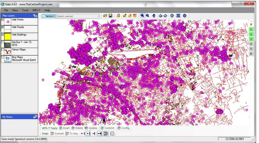
Test queries were run with BBOX parameters that covered large and larger geographic regions and increasing MaxFeatures, resulting in increasing volumes of GML streaming to the Gaia application as shown in the figure below.
19 Copyright © 2013 Open Geospatial Consortium
Since applications such as Gaia include functions for both accessing and rendering GML data simultaneously (as shown in Figures 2 and 3) performance metrics were obtained for data access only by using test applications from The Carbon Project that request and retrieve the data, but do not render it.
The following GML FeatureTypes were included in the testing, each FeatureType represented the total amount of OSM data (as GML) available for over Haiti and the Dominican Republic -
Haiti Points
Haiti Roads
Haiti Buildings
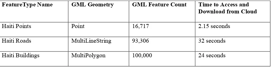
The maxFeatures property on the request sequence was set to 100,000 features for each FeatureType. The timestamp indicated in Table 2 below is the time it took to make the request and parse it into usable objects without rendering. All times listed are the averages calculated by making multiple requests for streaming GML.
Table 2 - Metrics on accessing test data using GML streaming
FeatureType Name GML Geometry GML Feature Count Time to Access and Download from Cloud
Haiti Points Point 16,717 2.15 seconds
Haiti Roads MultiLineString 93,306 32 seconds
Haiti Buildings MultiPolygon 100,000 24 seconds
Both the Haiti Buildings and Haiti Points FeatureType had four properties each
(including Geometry). The Haiti Roads FeatureType had had seven properties (including Geometry). The GML data was deployed on WFS on the Microsoft Azure Cloud
20 client was a two year old commodity desktop system running Microsoft Windows
software.
Additional performance metrics were obtained for data access by GML streaming using test applications from The Carbon Project that request and retrieve the data, and insert the data into a SpatiaLite database as described in Section 8 below.
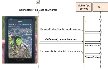
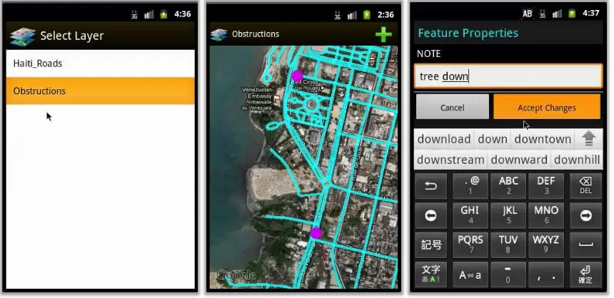
7.3 Testing Access with OGC Mobile Client Applications
Data access with GML Streaming was also tested on a Mobile app for Android operating system. In this test the WFS with Streaming GML was registered on the CarbonCloud Sync application service. Mobile users were then able to communicate with a
CarbonCloud Sync application service via OGC WFS operations and access features across an open standard WFS interface suitable for mobile users.
For example, the figure below shows the app accessing GML test data for the Haiti Buildings feature type.
Mobile App Service Connected Field User on Android
DescribeFeatureType() :type description
GetFeature() :feature instances
StreamContent
WFS
Transaction() :InsertUpdateDeletefeatures
StreamContent
21 Copyright © 2013 Open Geospatial Consortium
7.4 Transaction Handling in the Basic Workflow for Streaming GML
While the basic workflow supports reading features from the service, WFS may also support the ability to perform data update operations via Transactions operations. The Web Feature Service Transactional (WFS-T) standard defines a set of operations that include insert, delete, and update of features. In most cases the changes will be published and be available to other end-users of the services. Transaction operations were tested with obtained Point, MultiLineString and MultiPolygon GML data and the mobile application.
7.5 Other Client Applications
Streaming GML access was tested on a Silverlight web application developed by
Lockheed Martin utilizing the ESRI ArcGIS API and custom built client libraries (Figure 5). This application allows the user to navigate the map, search for GIS data (i.e. ArcGIS services, WFS, WMS, WMTS, KML, and GeoRSS) and then combine data from
22
Figure 5 - GML Streaming accessed by Lockheed Martin application
In addition, Streaming GML access was successfully tested on the ESRI ArcGIS 10.0 desktop. Access required the setting of a number of parameters in the desktop
application, however, once set GML data access was seamless.
8 SQLite/SpatiaLite Workflow for GML Streaming
23 Copyright © 2013 Open Geospatial Consortium
This section describes how the OWS-9 effort assessed, developed and tested the delivery of large payloads consisting of geospatial data sets and/or collections of data sets to SpatiaLite to store the data for use by mobile applications using GML.
8.1 SQLite/SpatiaLite and GeoPackage Overview
SpatiaLite is an open source library that extends the SQLite core to support Spatial SQL capabilities. SQLite is a software library that implements a self-contained, serverless, transactional SQL database engine. SpatiaLite implementations described in this document use the draft GeoPackage specification.
The draft OpenGIS® GeoPackage Implementation Specification defines a GeoPackage as
a self-contained, single-file, cross-platform, serverless, transactional, open source RDBMS data container with table definitions, relational integrity constraints, an SQL API exposed via a “C” CLI and JDBC, and an XML manifest that together act as an exchange and direct-use format for multiple types of geospatial data, especially on mobile / hand held devices in disconnected or limited network connected environments.
Direct use requirements include the ability to access and update data in a “native” format without intermediate format translations in an environment (e.g. through an API) that guarantees data model and data set integrity and identical access and update results in response to identical requests from different client applications. Specifically, a
GeoPackage can contain multiple vector feature types, rasters from various sources, and multiple tile matrix pyramids. A GeoPackage supports storage of rasters and tiles in multiple specified image file formats. Tiles are expected to be georectified or
orthorectified view-space images, while rasters could also be raw “as collected” images. An individual GPKG may contain one, some or all of these types of geospatial data. The GeoPackage API provides Simple Features SQL access to vector features and geometries, and additional SQL functions on Rasters, Tiles, and their descriptive metadata. The GeoPackage API supports implementation of data content management and integrity constraints via SQL triggers.
24
8.2 Creating GeoPackage from WFS
The streaming approach may be used to create GeoPackages from WFS serving a set of features encoded as GML. As part of this project a ‘GeoPackage Manager’ was
developed to access the cloud-based WFS established by The Carbon Project and support testing this workflow.
Figure 6 and the following descriptions illustrate the sequence of operation calls to initialize a GeoPackage, create feature tables in SQLite, obtain GML as streamed data from a datastore across the WFS interface and populate the GeoPackage.
1. A GeoPackage Manager component initializes a GeoPackage on SQLite.
2. A GeoPackage Manager requests a capabilities document from the WFS.
3. A GeoPackage Manager component creates feature tables in GeoPackage.
4. A GeoPackage Manager component imports GML into GeoPackage.
Based on this workflow the OWS-9 GeoPackage Manager component implemented by The Carbon Project provided the ability to initialize a GeoPackage on SQLite from a Streaming GML source implementing the OGC Web Feature Service interface, and load Streaming GML data into it.
25 Copyright © 2013 Open Geospatial Consortium
GeoPackage Manager
StreamGMLContent WFS
GetCapabilities() :servicemetadata
ImportData :GetFeature() :feature instance CreateFeatureTable
InitializeGeoPackage
Figure 6 - Creating a GeoPackage from Streaming GML using The Carbon Project GeoPackage Manager component
26 <cp:Field xmlns:cp="
[[http://www.thecarbonproject.com/][http://www.thecarbonproject.com]]"> <cp:Name>shape</cp:Name>
<cp:Title>shape</cp:Title> <cp:Description/>
<cp:FieldType>Point</cp:FieldType> <cp:IsRequired>False</cp:IsRequired> </cp:Field>
<cp:Field xmlns:cp="
[[http://www.thecarbonproject.com/][http://www.thecarbonproject.com]]"> <cp:Name>osm_id</cp:Name>
<cp:Title>osm_id</cp:Title> <cp:Description/>
<cp:FieldType>Integer</cp:FieldType> <cp:IsRequired>False</cp:IsRequired> </cp:Field>
<cp:Field xmlns:cp="
[[http://www.thecarbonproject.com/][http://www.thecarbonproject.com]]"> <cp:Name>timestamp</cp:Name>
<cp:Title>timestamp</cp:Title> <cp:Description/>
<cp:FieldType>String</cp:FieldType> <cp:MaxLength>20</cp:MaxLength> <cp:IsRequired>False</cp:IsRequired> </cp:Field>
<cp:Field xmlns:cp="
[[http://www.thecarbonproject.com/][http://www.thecarbonproject.com]]"> <cp:Name>name</cp:Name>
<cp:Title>name</cp:Title> <cp:Description/>
<cp:FieldType>String</cp:FieldType> <cp:MaxLength>48</cp:MaxLength> <cp:IsRequired>False</cp:IsRequired> </cp:Field>
<cp:Field xmlns:cp="
[[http://www.thecarbonproject.com/][http://www.thecarbonproject.com]]"> <cp:Name>type</cp:Name>
<cp:Title>type</cp:Title> <cp:Description/>
27 Copyright © 2013 Open Geospatial Consortium
</cp:Fields>
</cp:CarbonMetadata>
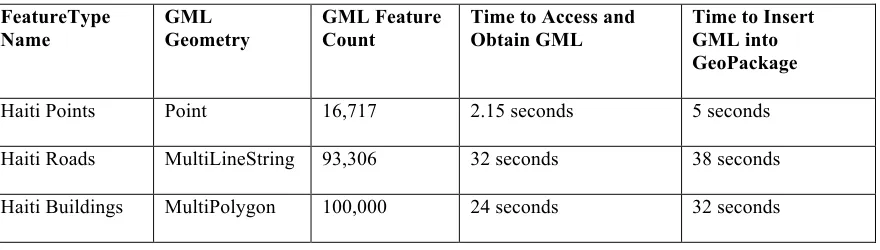
The GeoPackage Manager component was also leveraged to obtain additional
performance metrics for data access by GML streaming to request and retrieve the data, and insert the data into a SpatiaLite database, as shown in the last column of the table below. Both the Haiti Buildings and Haiti Points FeatureType had four properties each (including Geometry). The Haiti Roads FeatureType had had seven properties (including Geometry).
Performance metrics on the time to insert the obtained GML data into a SpatiaLite database are shown in the table below:
Table 3 - Time to insert GML into SQLite/GeoPackage for use on Mobile devices FeatureType
Time to Access and Obtain GML
Time to Insert GML into GeoPackage
Haiti Points Point 16,717 2.15 seconds 5 seconds
Haiti Roads MultiLineString 93,306 32 seconds 38 seconds
Haiti Buildings MultiPolygon 100,000 24 seconds 32 seconds
8.3 Using GeoPackage for Connected/Disconnected Mobile Apps
28
Figure 7 - GeoPackage mobile app on Android
In this Integration Experiment, data in the GeoPackage created from Streaming GML feature data sources described in Section 7 was transferred to an Android mobile application from The Carbon Project. Once the GeoPackage was loaded this mobile application provided the capability to access feature data from the GeoPackage, Pan, Zoom, Select Layers, access data, and edit (Inert, Update, Delete) Feature Geometries and Properties.
For this project The Carbon Project’s mobile application made Transactions against the SQLite/SpatiaLite and the Streaming GML services (exposed as WFS). In this approach, the features and changes are applied to the main table in GeoPackage. Transactions are captured in a separate table, so the application knows what has changed. As a sync occurs, the transaction table gets emptied and may be sent to a GeoSynchronization service or the WFS. In this approach, transactions are stored as the feature type id, feature id, operation and XML in a new table. The XML is WFS Transactions XML. When a sync is performed, a WFS:Transaction is created containing all the
Inserts/Updates/Deletes in the table, and then sent. The table is emptied if the
29 Copyright © 2013 Open Geospatial Consortium
GeoPackageTransaction GeoPackage
Manager
StreamGMLContent WFS | App Service
GetCapabilities() :servicemetadata
ImportData :GetFeature() :feature instance CreateFeatureTable
InitializeGeoPackage
SendGeoPackage Disconnected/Connected
Mobile App User
AccessGeoPackage
Transaction() :InsertUpdateDeletefeatures
Figure 8 – Sequence Diagram for GeoPackage creation from Streaming GML, and use on mobile application
9 Recommendations
Key recommendations for future work include
30
Transactions into GeoPackage.
GeoSynchronization with Streaming GML and GeoPackages.
Of particular utility to the dissemination of large payloads consisting of geospatial data sets and/or collections of data sets between machines connected via a network is OGC Change Request (CR) 132, OGC Document 11-004. This CR recommends ‘Adding resolution parameters to GetFeatureRequest to support visualization clients’ using Web Feature Service (WFS) Implementation Specification 2.0. The scope of this CR covers the addition of three optional parameters to the GetFeature request. The parameters are called: resolution, resolutionX and resolutionY. In this approach, you either specify resolution OR resolutionX/resolutionY. If you specify resolution this implies this means that the resolution in the X and Y directions is that same. Otherwise you can set the X and Y resolution independently. The resolution parameters may be used to generalize geometry suitable for the specified resolution. This means that non-visible segments are removed or it may even mean not displaying anything if you are zoomed too far out.