past, present, and the future
Handoko Adi Susanto, Suraji, Mutsunori Tokeshi
Coastal Ecosystems
, 2015, vol 2, 21-41
Management of coral reef ecosystems in Indonesia:
past, present, and the future
Handoko Adi Susanto1
, Suraji2
, Mutsunori Tokeshi3
1
Rare Indonesia, Jl. Gunung Gede 1 No.6 Bogor, West Java 16151, Indonesia 2
Directorate of Conservation and MarineBiodiversity, Ministry of Marine Affairs and Fisheries, Indonesia 3
Amakusa Marine Biological Laboratory - Kyushu University, Reihoku-Amakusa, Kumamoto 863-2507, Japan Corresponding author: HA Susanto, e-mail: [email protected]
Abstract
Spanning an area of highest marine biodiversity in the tropical western Pacific known as
the Coral Triangle, Indonesian archipelago has an extensive coral reef coverage with well
over 500 coral species having been recorded. There is no doubt that coastal and marine
resources, mostly in the form of coral reef ecosystems, have contributed signiicantly to the
economic development of the country. Recognizing the importance of marine conservation
for sustainable utilization of resources and environments, Indonesian government has
committed itself to establishing and effectively managing marine protected areas (MPAs)
covering 200,000 km
2by 2020. There has been a tremendous growth in MPAs in Indonesia:
from only 54,198 km
2in 2003, the total protected area tripled to 164,511 km
2as of July
2015. Of those MPAs established, 30% are managed by the Ministry of Environment and
Forestry, 35% by the Ministry of Marine Affairs and Fisheries, and the remaining 35% by
local governments. The varied capacities, foci and funding of these institutions generate
complexity and inefficiency in resource use, which could undermine the effectiveness of
MPAs. The immediate tasks have been identiied, e.g. attaining the MPA target to protect an
additional 35,500 km
2of coastal areas, as well as managing the existing ones in eficient and
sustainable manners. This paper details the status of Indonesian MPAs from historical and
current policy-based perspectives, together with consideration of challenges that lie ahead
for improved MPA management towards the future.
Keywords
: Coral Triangle, coral reef management, marine protected areas, management
effectiveness
Background
Located between 6°08’ N - 11°15’ S in latitude and between 94°45’ E - 141°05’ E in longitude, Indonesia is the largest archipelago state in the world, with 17,504 islands and the total coastline of 95,181 km. Indonesia’s area of national jurisdiction is about 7.73 million km2, consisting of 1.93 million km2 land area, 2.8 million km2 of archipelagic waters, 0.3 million km2 of territorial seas and 2.7 million km2 of Exclusive Economic Zones (EEZ).
The coastal zones represent a highly productive ecosystem that serves as an important base for the country’s economic growth. Over 55% of the national isheries harvest comes from capture isheries in coastal areas. Some of the richest areas of biodiversity are found in the coastal zones of the country, including coral reefs, mangrove swamps, seagrass beds, lagoons, and estuaries (Dahuri 2003). Indonesia’s coastal zones are home to 2,500 species of mollusks, 2,000 species of crustaceans, 6 species of sea turtles, 30 species of marine mammals, and over 2,000 species of ish, and more than 500 species (>70 genera) of hard corals.
Forming part of the Coral Triangle, an area of great marine biodiversity in tropical western Pacific, coral reef
areas of Indonesia constitute the second largest coral reef in the world after the Great Barrier Reef in Australia (Nontji 2002). In Indonesia, economic beneits from the coral reefs through marine tourism are estimated at US$1,000,000 km-2 year-1 (UNEP 2006).
The Maximum Sustainable Yield of Indonesian marine capture fisheries is about 6.5 million tones, and potential production from mariculture is about 42 million tons per year (MMAF 2013). Approximately 75% of Indonesian cities and 80% of industrial facilities are located in coastal areas. Of about 60 oil and gas basins in the country, 70% are in the sea. Indonesia is also predicted to have a reserve of about 9.1 billion barrels oil and gas. In addition, there are many other forms of economic generation including marine transport services, maritime industry, marine tourism, exploitation of alternative industrial and medicinal materials, etc.
Indonesian marine biodiversity encompasses genetic, species and ecosystem components with multi-faceted benefits including economic, social, cultural, and aesthetic aspects. Understanding the value of biodiversity and its beneits thus necessitates the development of management strategies in accordance with sustainable development principles. Marine biological resources such as coral reefs,
seagrass beds and mangroves with a variety of fish and other organisms possess the potential of economic and environmental services‡
that are highly beneficial to the economy of coastal communities (Dahuri 2003).
From socio-economic perspectives, most people in Indonesia largely depend on coastal and marine resources. However, the abundance of these resources has still not significantly improved the welfare of people especially in remote coastal areas and small islands. Currently, coastal communities are characterised by poverty, low education levels, low health quality, no or little access to the capital, and are often powerless to resolve problems. In Indonesia, as a developing country, poverty and low levels of understanding of the environment are often regarded as justification for the dependence of coastal communities on marine resources in destructive and unsustainable manners. Marine Protected Areas (MPA) can be used as one of the effective ways of coastal and marine resource management, in particular by protecting ecologically-significant areas as sanctuaries for reef-associated organisms (Salm et al. 2000). These will provide refuges for species targeted for fisheries and contribute to increasing fisheries resources and productivity in surrounding areas (Claudet et al. 2006). In addition, MPAs can also support sustainable tourism
which would in turn strengthen the economy of coastal communities (Plates 1-5).
Coral Reefs in Indonesia
Coral reefs are massive structures made of calcium carbonate (CaCO3) produced by living organisms, that
harbor a wide variety of plants and animals (McAllister et al. 1994; Hinrichsen 1997). Coral reefs are one of the most productive ecosystems in the world, rivaling rain forests in their richness of life (Birkeland 1997). They are also natural recorders of past climate and environmental variation (Birkeland 1997; Nontji 2002).
Indonesian coral reefs cover 32,000 km2 or about 18% of world coral reef area (Ministry of Forestry and MMAF 2010); of these, around 25,000 km2 of coral reefs have been mapped by the Agency for Geospatial Information (Badan Informasi Geospasial ~ BIG). Coral reefs in Indonesia are typically classified into four types, namely fringing reefs, patch reefs, barrier reefs and atolls, of which the largest proportion among Indonesian coral reefs is fringing reefs. The atoll of Takabonerate, South Sulawesi, constitutes the third biggest atoll in the world. Coral species that dominate
Figure 1: Number of coral species found around Indonesia
(modiied from KLH 2008 and Mustika et al. 2013).
in nearly all coral reefs of Indonesia are Acropora spp,
Montipora spp and Porites spp. The number of species found in Indonesia to date is 590 belonging to 82 genera (Veron 2001). Figure 1 shows coral diversity in different regions of Indonesia.
However, coral reefs in Indonesia are at a constant risk of degradation. A long-term monitoring from 1993 to 2012, encompassing more than 1000 stations in 78 areas, indicated that as of the end of 2012, only 5.3 % of coral reefs in Indonesia were in excellent condition, 27.2% in good condition, 37.3% in fair condition and 30.5% in poor condition (Table 1). Evaluation of coral reefs from 2000 to 2012 indicated that there was no drastic change over
these thirteen years (Fig. 2). There was a slight decline in the proportion of reefs in the excellent category, from 6.9% in 2000 to 5.3% in 2012, while those in good and fair categories showed a slight increase (good: 25.3% to 27.1%, fair: 33.1% to 37.3%).
History of coastal management and conservation in Indonesia: before 2000
The history of coastal management and conservation in Indonesia goes back to the time before Dutch occupation. Traditionally, Indonesians utilised natural resources in their
Region No. of sites No. of stations condition (%)
excellent good fair poor
Western 36 504 5.4 29.6 34.3 30.8
Central 27 308 5.5 29.6 44.8 20.8
Eastern 15 321 5.0 21.2 34.6 39.3
Total 78 1133 5.3 27.2 37.3 30.5
surrounding areas in controlled and sustainable manners. There is indeed substantial evidence of sustainable resource use in local societies, as exemplified by the existence of resource-management systems such as ‘Panglima laot’ in Aceh, ‘Lubuk larangan’ in Sumatra, ‘Kelong’ in Batam, ‘Mane’e’ in North Sulawesi, ‘Sasi’ in Maluku and Papua, ‘Awig-awig’ in Lombok, ‘Bapongko’ in Central Sulawesi, and ‘Ola nua’ in East Nusa Tenggara.
Mulyana and Dermawan (2008) noted that, during Dutch occupation, conservation movement began in 1714 when Chastelein donated 6 ha of land in the Banten region to serve as nature reserve. Thereafter, in 1889 Cibodas was oficially declared by the Director of Bogor Botanical Garden as the irst nature reserve for the purpose of preserving the forest as well as its associated flora and fauna. In 1913, the Netherland Indies Society for the Protection of Nature, under the leadership of Dr. S.H. Koorders, proposed 12 conservation areas, namely Krakatau island, Papandayan Mountain, Ujung Kulon, Gunung Bromo, Nusa Barung, Alas Purwo and Ijen crater together with its plateau and some sites in Banten area. Notably for marine conservation in Indonesian waters, the state gazette No. 396 was issued in 1920 with the aim of protecting fisheries resources and banning isheries that used toxic materials, anesthetics and explosives. Subsequent to this, the state gazette No. 167 of 1941 dealt with the administration of nature and wildlife reserves.
From the time up to the Japanese occupation, and twenty years after independence, Indonesia inherited the
conservation measures taken by the Netherland Indies government. Further, there was a conservation policy adopted by the government during Japanese occupation (Satria et al. 2006). Some significant development thereafter includes the undertaking of marine research through ‘Baruna’ and ‘Cenderawasih’ operations and the introduction of Wawasan Nusantara concept* by Juanda Declaration of 13 December 1957 which was reinforced by Law UU No. 4 of 1960.
In 1971 the Directorate of Nature Conservation and Wildlife Management was established under the Ministry of Agriculture as an indication of the government’s seriousness towards nature conservation activities. In 1973 Indonesia also ratiied CITES (Convention on International Trade in Endangered Species of Wild Flora and Fauna), which was confirmed by the Presidential Decree No. 43 of 1978. During the period 1974-1983, the Indonesian government obtained assistance from FAO to manage its National Park Development Program. Within the time span, the government inaugurated 10 new National Parks and the Ministry of Forestry and State Ministry for Supervision of Development and Environment, now known as the State Ministry for Environment (Mulyana and Dermawan 2008). An important action taken by the Directorate General of Forest Protection and Nature Conservation (PHPA), Ministry of Forestry in 1984, was to publicise the “National Marine Protected Area System” in collaboration with WWF and FAO. This publication, called the ‘Marine Conservation Data Atlas’, containing the frameworks for various activities of
Figure 2: Coral reef conditions in Indonesia from 2000 to 2012 (adapted from COREMAP 2014).
2000
2002
2004
2006
2008
2010
2012
Propor
*In 1957, Indonesian government announced the policy of 'Wawasan Nusantara' (Unity/Archipelagic Outlook) to emphasize the country’s unity as
marine protection, the basis for selection and determination as well as prioritised areas for the development of marine protected areas (Huffard et al. 2012). The system was to follow up on the government’s commitment to international moves of expanding conservation areas in marine spheres. The values of marine resources in national development have begun to be recognized since the publication of the State Policy Guidelines (GBHN) 1998. In the document it was explained that the coastal zones, the ocean, watershed and the air must be managed with due regard to the environments and their natural resources. Indeed, by 1997 more than 26,000 km2 were incorporated into 24 conservation areas, among which six were in the form of national parks, namely Kepulauan Seribu, Karimunjawa, Teluk Cenderawasih, Bunaken, Wakatobi, and Takabonerate (Mulyana and Dermawan 2008).
Conservation of biological resources was legally supported by the ratification of Law No. 5 of 1990 that governs all aspects for protection, preservation and utilization of biological resources and their ecosystems. According to this regulation, conservation is administered by protection of life supporting, preservation of diverse fauna and flora and its ecosystem, and sustainable utilization of biological natural resources and its ecosystem. This law also shifted the paradigm of conservation that merely focused on area
Islands’, which was later changed to the ‘Directorate for Area and Fish species Conservation’ (known as Dit. KKJI) and more recently to the ‘Directorate of Conservation and Marine Biodiversity’ (Direktorat Konservasi dan Keanekaragaman Hayati Laut ~ KKHL). Initially, Dit. KKJI developed the concepts of conservation and provided guidelines to improve the management of MPAs. At the same time, the directorate facilitated regional conservation effort by developing the “Local Marine Protected Areas”, i.e. the MPAs initiated and managed by district and provincial governments. Recently there have been many initiatives from district and provincial governments to develop local MPAs to enhance conservation areas in line with the policy of sustainable isheries resource management.
Law no. 31 of 2004 on isheries with its amendment (Law no. 45 of 2009) concerned fishery resource management and conservation. This law stipulated the right of the Minister of Marine Affairs and Fisheries to implement management measures to control fishing activities. These include: (i) specifying fishing methods or gear; (ii) determining the maximum sustainable yield (MSY) or total allowable catch (TAC) for domestic and foreign ishery; (iii) specifying ishing and aquaculture activities; (iv) disallowing activities such
conservation to the conservation of ecosystems, species and genetics.
In 1998, Government released regulation No. 68/1998 to clarify the criteria and type of conservation areas. Based on this regulation, conservation areas were divided into two categories, namely the ‘Nature Reserve Area’ and the ‘Nature Conservation Area’. The Nature Reserve Area consists of nature reserves and wildlife reserves, while the Nature Conservation Area consists of national parks, grand forest parks and nature recreational parks.
Historical path on coastal management and conservation in Indonesia: after 2000
Coastal and marine resources received greater attention with the establishment of the Department of Marine Exploration and Fishery in 1999, which subsequently changed to Department of Marine Affairs and Fisheries and more recently upgraded as “Ministry of Marine Affairs and Fisheries” (MMAF). In order to handle activities relating to coastal and marine conservation, the Ministry established the Directorate for Conservation and Marine National Park (Direktorat Konservasi dan Taman Nasional Laut ~ KTNL) under the ‘Directorate General of Marine, Coasts, and Small
Reef in Derawan, East Kalimantan (photo: HA Susanto)
km2), the Nature Recreational Park (Taman Wisata Alam: TWA) of Kepulauan Kapoposang (500 km), the TWA of Gili Indah (25.94 km2), the TWA of Kepulauan Padaido (1,830 km2), the CA of Taman Laut Banda (25 km2), and the TWA Pulau Pieh (399 km2). The new nomenclatures of eight MPAs handed over were: the Marine Nature Reserve (SAP) of Kepulauan Aru bagian Tenggara; the SAP of Kepulauan Raja Ampat; the SAP of Kepulauan Waigeo sebelah Barat; the Marine Recreational Park (Taman Wisata Perairan: TWP) of Kepulauan Kapoposang; the TWP of Gili Ayer, Gili Meno, and Gili Trawangan; the TWP of Kepulauan Padaido; the TWP of Laut Banda; and the TWP of Pulau Pieh.
In order to implement integrated and sustainable coastal and marine resource management measures in general and the MPA management in particular, the Ministry of Marine Affairs and Fisheries established the ‘Technical Implementing Units’ in several regions. In March 2008, the Agency for the National Marine Protected Area (BKKPN) Kupang and the Agency for the Coastal and Marine Resource Management (BPSPL) Padang were established. Subsequently, these were followed in November 2008 by the establishment of the Agency for the Coastal and Marine
Resource Management (LPSPL) Sorong, the BPSPLs of Denpasar, Makassar, and Pontianak. In January 2009 the Agency for the National Marine Protected Area (LKKPN) Pekanbaru was established, followed a year later by the LPSPL of Serang. The main duties of BKKPN/LKKPN are to undertake management, utilization and supervision of national marine areas for conservation of isheries resources and environments in accordance with applicable laws and regulations, while the main duties of BPSPL/LPSPL are to implement the management (i.e. protection, conservation and sustainable utilization) of coastal/ marine/small islands resources (Susanto 2011).
In May 2009, the country hosted a major international meeting, the World Ocean Conference (WOC), where basic and applied research as well as case studies on costal and marine resource management were presented. This event also served as a forum for discussion, communication and sharing of experiences among the world’s marine experts. On that occasion, the Minister of Marine Affairs and Fisheries and the Governor of East Nusa Tenggara (NTT) declared Savu Sea as a Marine National Park (Taman Nasional Perairan: TNP). The Savu Sea TNP covers an area of
35,000 km2 and administratively exists in 10 regencies/cities within the Province of NTT (East Nusa Tenggara). The Savu Sea TNP was enacted by decree No. 5/Kepmen-KP/2014 with a management plan and zonation installed for the period 2014-2034, based on ministerial decree No. 6/ Kepmen-KP/2014.
Simultaneously with the WOC 2009, Indonesia also emphasized its commitment to develop MPAs up to 200,000 km2 by 2020. The commitment was supported by the neighboring countries within the Coral Triangle including Malaysia, the Philippines, Solomon Islands, Papua New Guinea and Timor Leste, and a commitment of funding support from the USA and Australia. The commitment was also followed up by various activities that could support the development and management of MPAs, one of which is the preparation of the National Plan of Action (NPoA) and the Regional Plan of Action (RPoA), the latter forming the basis of the former including the objectives and targets to be achieved. There are ive goals in the RPoA:
Goal 1: Priority Seascapes designated and effectively managed
Goal 2: Ecosystem Approach to Management of Fisheries (EAFM) and other marine resources fully applied, Goal 3: Marine Protected Areas (MPAs) established and
effectively managed
Goal 4: Climate Change adaptation measures achieved Goal 5: Threatened species status improved
Legal basis of MPA management in Indonesia
Legal arrangements are vital for facilitating sustainable management of coastal and marine resources, while curving environmental pollution and harmful fishing activities. Indonesia has a complex, hierarchical legal system: there are seven levels of laws: 1) basic constitution, 2) General Peoples Assembly decrees, 3) Laws and Acts; 4) Government Regulations substituting Laws/Acts, 5) government regulations, 6) Presidential decrees; 7) regional government regulations/ministerial decrees.
The following is a digest of legal instruments concerned with planning and management of MPAs in Indonesia:
• Law No. 5 of 1990 regarding the Conservation of Biological Resources and their Ecosystem.
Kupang East Nusa Tenggara (photo: HA Susanto)
Air, Seribu Islands (photo: M Tokeshi)
Plate
3
species diversity and their ecosystems, and the sustainable use of biological resources and their ecosystems; (ii) sustainable, harmonious, and balanced use of biological resources; and (iii) the development of human capacity and quality of life. The protection of life-support systems implies safeguarding the ecological processes that are vital for the survival of living organisms and for enhancing human well-being and the quality of life.
• Law No. 31 of 2004 as amended by Law No. 45 of 2009 regarding Fisheries.
This is the legal basis for fisheries management in Indonesia. Enacted on 6 October 2004, it replaced the former Fisheries Act (No. 9 of 1985), and then was revised again by the Law No. 45 of 2009. This concerns a wide range of fishery-related issues including management, entrepreneurship, statistic and information systems, taxes, research and development, capacity-building programs, local ishers empowerment, and surveillance. The Fisheries Law prohibits the use of illegal fishing methods and equipment that pollute and degrade fisheries and ecosystems with maximum penalties of six years in prison and a ine of up to Rp. 1.2 billion (c. US$100,000).
• Law No.27 of 2007 as amended by Law No.1 of 2014 regarding Management of Coastal Zones and Small Islands.
This aims to protect, conserve, rehabilitate and utilize the resources of coastal zones and small islands in a sustainable manner. Small islands and coastal areas can be used for conservation, training and education, research and development, mariculture, marine tourism, cattle farming, organic agriculture and other isheries and marine industry (Article 23). This law regulates conservation activities in order to guarantee the sustainability of coastal and small island ecosystems, to protect habitats and migration routes of fish and other marine biota, and to protect traditional cultural sites (Article 28). This law also stipulates the obligation of local governments to develop a set of planning documents including strategic planning, management planning, marine spatial planning or zoning, and action planning.
• Law No. 32 of 2004 as amended by Law No. 23 of 2014 regarding Regional Government
This law grants authority to provincial governments for
Plate
4
managing their own natural resources, including the conservation and management of coastal resources. Article 27.2 grants to the Provinces jurisdiction over Indonesia’s territorial sea which extends up to 12 nautical miles from the archipelagic baseline. Furthermore, central government has authority to establish special areas within provincial and district areas for national reasons including free trade area, forest reserve, marine park, nature reserve, and cultural reserve. The new Law (No.23 of 2014) disannulled the authority of district or city governments on managing coastal waters.
• Law No. 32 of 2009 regarding Protection and Management of Environment
The aim of this law is to create environmentally sustainable development through planning policies and rational exploitation, development, maintenance, restoration, supervision and control. The Environmental Management Law is a comprehensive law with regard to environmental management in Indonesia. It adopts a holistic approach based on the archipelagic concept of the essential unity of the living space of Indonesians which covers land, air space and sea under Indonesian sovereignty (Article 3).
• Law No. 32 of 2014, the “Ocean Act (Marine Affairs)”
This act describes the coverage, jurisdiction and governance of seas and marine resource utilization, including energy and mineral resources, non-conventional resources, marine ecotourism, marine transportation, marine infrastructures, research and technology, data and information systems. The Ocean Act regulates marine spatial planning in internal and archipelagic waters within the Exclusive Economic Zones (EEZ). Marine spatial plans provide bases for the implementation of development programs following the blue economy principles to achieve sustainable ocean management. The Ocean Act also regulates the protection of marine biodiversity, including conservation in the high seas.
• Government Regulation No. 68 of 1998 as amended by No. 28 of 2011 regarding Management of Nature Reserve Area and Nature Conservation Area
This defines categories of protected areas: 1) ‘nature reserve’ is a specific area on land or in water which has a function as an area for biodiversity preservation of plants and animals and ecosystems; 2) ‘wildlife reserve’
is an area that, because of its nature, has specific plants, animals and their ecosystems that need to be conserved; 3) ‘national park’ is a nature preservation area on land and/ or in waters which consists of original ecosystems of plants animals that are managed by zonation system and used for research, education, tourism and recreation; 4) ‘grand forest park’ is a nature preservation area on land and/or in waters intended for the collection of origin or non-origin plants and animals that are used for research, education, tourism and recreation; and 5) ‘nature recreational park’ is a nature preservation area on land and/or waters intended for tourism and recreation. This regulation also encourages MPA managers to involve local community in managing the areas.
• Government Regulation No. 60 of 2007 regarding Fisheries Resources Conservation
The regulation is a derivative of the Fisheries Law and explains general provisions, conservation of ish resources, the utilization of fish resources, education and training in fisheries’ resource conservation, community development, oversight of ish resource conservation, sanctions, and other provisions. This regulation also deines separate governing authorities for management (MMAF) and scientiic research/ information (LIPI) of ish resources. The general types of MPA and zoning systems are also explained.
It is stated that ‘Marine Protected Area (MPA)’ refers to a marine water area, which is protected and managed through a zoning system, to achieve sustainable management of fish resources and ecosystems. The zoning system itself is deined with four categories: core zone, utilization zone, sustainable isheries zone, and other zones. MPA consists of Marine National Park, Marine Nature Tourism Park, Marine Wildlife Reserve, and Fisheries Reserve.
• Ministerial Regulation KP No. Per.17/Men/2008 regarding Conservation Area in the Coastal Zones and Small Islands.
This describes general provisions, conservation area categories, establishment processes of conservation area in the coastal zone and small islands, management authority for conservation area, patterns and procedures for management, licensing and financing, transitional provisions and other provisions.
• Ministerial Regulation KP No. Per.02/Men/2009 regarding Procedure for Designation and Enactment a Marine Protected Area
designation of MPA, arrangement of MPA boundaries, and transitional provisions.
• Ministerial Regulation KP No. Per.35/Men/2013 regarding the Procedures for the Designation of Fish Species Protection
This describes general provisions, criteria for the protection status of ish species, types of ish species protection status, procedures for designation of ish species protection status, changes in fish species protection status, and transitional provisions.
• Ministerial Regulation KP No. Per.04/Men/2010 regarding the use of fishes including their genetical resources.
This regulation describes general provisions, protection and utilization of ish species and their genetical resources, determination of quotas, permits for the use of fishes, ishery levies, supervision and control, sanctions and other provisions.
• Ministerial Regulation KP No. Per.30/Men/2010 regarding management and zoning plans of marine conservation areas.
This ministerial decree provides guidance concerning the development of management plans and zoning of MPAs. Zoning consisting of a core zone [minimum 2% of the total area], utilization zone, sustainable isheries zone and other zone) could not be separated from a management plan. A ‘Management plan and Zoning’ is to be prepared by a MPA management unit which should be established after the designation of a MPA. The regulation also emphasizes community involvement during management plan and zoning development processes.. A management plan should cover a period of 20 years with detailed strategies and programs separately identiied for every ive-year term.
Recent policy changes concerning marine protected areas in Indonesia
Based on Law no. 31 of 2004 and its amendment (Law No.
45 of 2009) and Government Regulation No. 60 of 2007 on fisheries resource conservation, the country introduced a new regime for the planning and management of marine protected areas (MPA). Government regulation No.60 of 2007 deined Marine Protected Area (MPA) as a marine area protected and managed through a zoning system, to achieve sustainable use of fisheries resources and environments. Under the new policies and regulations, the zoning system consists of four zones developed within a MPA, namely: core zones, sustainable isheries zones, tourism-use zones, and other zones. The zoning of MPA’s is shifting to multi-purpose zones by providing areas for sustainable fisheries and tourism activities, which were not previously emphasized. This has also enabled the planning and management of MPAs to be initiated by local governments through decentralized natural resource management policies. Local governments have full authority to manage their MPAs under guidance from the Ministry of Marine Affairs and Fisheries. This is in line with the mandate of Law No. 32 of
2004 on Regional Government, which noted that provincial governments have authority to manage marine waters up to 12 nautical mile and district governments up to one-third of the provincial’s authority. The zoning plan of a MPA should also take into account existing activities and input from local people, especially with respect to ishing grounds, traditional rights, and other customary laws. However, the new Law No. 23 of 2014 regarding Local Government only grants provincial government to manage coastal resources within 12 nautical miles of coast.
After the establishment of the Ministry of Marine Affairs and Fisheries (MMAF) by the government of Abdurahman Wahid in 1999, all the coastal and marine management activities were placed under the MMAF authority. The establishment of the MMAF meant major changes in governmental administrative system in Indonesia. For example, the management of marine fisheries, which had previously been under the Ministry of Agriculture, was transferred to the MMAF control. MMAF has responsibility
for the management of coastal and marine resources including conservation aspects. The Ministry of Forestry also transferred the management authority of some national MPAs to MMAF. Moreover, the article 78A of Law No.1/2014 mandates that all MPAs be under MMAF.
However, Indonesian bureaucracy is more complicated than it appears. In practice, at least, nine line departments, three state ministries, one coordinating ministry, four non-departmental government agencies and one inter-ministerial council are involved in coastal management at the national level.
The MMAF has been facing significant challenges in implementing new policies as mandated through fisheries laws and conservation regulations. Conservation programs in the past were based on centralistic policies without effective application towards sustainable utilization of resources. In addition, lack of participation during MPA designation processes led to low positive responses from local communities to support the conservation programs. Hurdles have been high: it is necessary to improve knowledge and understanding of new paradigms, increase
community involvement in the processes, and disseminate experiences from other sites (concerning the benefit of maintaining MPAs).
There are three legal institutions that have a mandate for managing MPAs: the Ministry of Marine Affairs and Fisheries, the Ministry of Environment and Forestry and the Local Government. With the current management system, redundancies have occurred in terms of authority, resource allocation and policies with accompanying conflicts of interest which tend to impact on management efficiency. As a result, the goal of MPA management for community benefits has not been achieved. In addition, management of local MPAs still requires technical assistance from the Ministerial level (which technically has responsibility to manage MPAs. However, with the enactment of Law No. 1 of 2014, discussion of the status of all local MPAs are under way (as of January 2015). Since districts no longer have authority over marine waters, those district-based MPAs might be elevated to the province-level MPAs or even national-level MPAs.
The development target of 100,000 km2 of MPAs was
2015 2016 2017 2018 2019
Additional MPA area (km2) 5,000 6,000 8,000 9,000 9,000
Effective Management 17 MPAs 28 MPAs 30 MPAs 33 MPAs 35 MPAs
declared in 2006 by the then Minister of Marine Affair and Fisheries, Prof. Dr. Rokhmin Dahuri before the officials of several countries. The commitment was then affirmed by the President Susilo Bambang Yudhoyono before the hearing of the meeting of CBD parties in March 2006 in Brazil who declared that Indonesia has a target to develop MPAs of 100,000 km2 by 2010 and double that by 2020. Further, in the plan of the Ministry of Marine Affair and Fisheries, it was stated that to achieve 200,000 km2 by 2020, the MPA areas were targeted to have reached 155,000 km2 in 2014, so that within the subsequent 6 years a minimum of 45,000 km2 new MPAs could be added. In reality, as of December 2014, a total of 164,511 km2 of MPAs has already been established in Indonesia (see GIS-based data: http// kkji.kp3k.kkp.go.id). Annual targets toward 200,000 km2 of MPAs by 2020 were given in the roadmap of the Directorate of Marine Conservation and Biodiversity 2015–2019 (Table 2).
Furthermore, given the fact that Indonesia has a territorial marine area of 3.1 million km2, the 2020 target would only achieve conservation of 6.5% of the total marine area. In contrast, the commitment made in the CBD 10 meeting in Nagoya expected Indonesia to achieve MPA coverage of 10% of the territorial marine area. This means that the country should designate 310,000 km2 of MPAs within its
territorial waters. In connection with this commitment, the Indonesian government has not issued its oficial statement regarding the timing of its achievement (Susanto 2011).
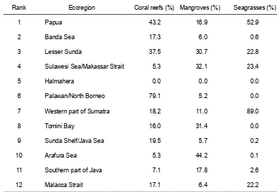
Areas prioritised for MPA development have been identiied by Huffard et al. (2012), based on three ecological criteria: (a) irreplaceability, which includes the level of endemism, taxonomic uniqueness, the existence of rare species associated with diverse habitats including coral reefs, seagrasses and mangroves; (b) vulnerability to changes and natural disturbances, and (c) habitat’s representation within the planning area. Consequently, 12 bio-ecoregions have been recognized, ranging from the 1st rank (Papua as the highest conservation priority) to the 12th (the Strait of Malacca as the lowest conservation priority). Figure 3 shows the ranking of 12 bio-ecoregions in Indonesia.
Current status of marine protected areas in Indonesia
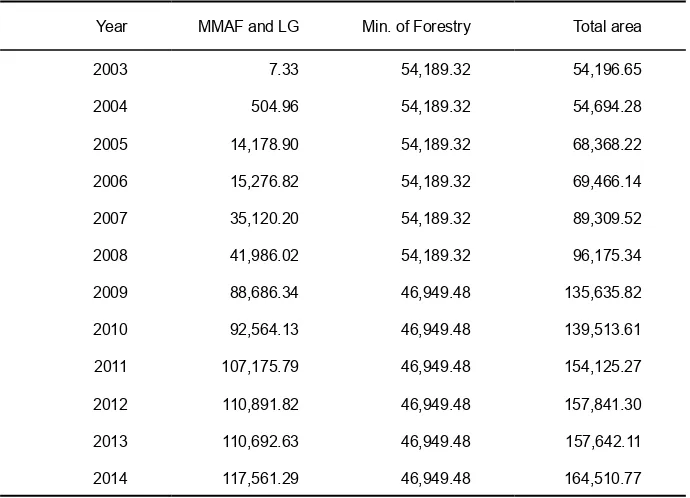
Indonesian MPAs have increased significantly since 2003 (Table 3). In 2003 total new MPAs amounted to only 54,200 km2 and most of these were initiated by the Ministry of Forestry (MoF), with 7.33 km2 MPAs (i.e. less than 1%) being the initiatives of MMAF. By the end of 2014, however,
Figure 3: The 12 bio-ecoregions ranking for marine biodiversity conservation in Indonesia
Year MMAF and LG Min. of Forestry Total area
2003 7.33 54,189.32 54,196.65
2004 504.96 54,189.32 54,694.28
2005 14,178.90 54,189.32 68,368.22
2006 15,276.82 54,189.32 69,466.14
2007 35,120.20 54,189.32 89,309.52
2008 41,986.02 54,189.32 96,175.34
2009 88,686.34 46,949.48 135,635.82
2010 92,564.13 46,949.48 139,513.61
2011 107,175.79 46,949.48 154,125.27
2012 110,891.82 46,949.48 157,841.30
2013 110,692.63 46,949.48 157,642.11
2014 117,561.29 46,949.48 164,510.77
Table 3. MPA development in Indonesia in 2003-2013 (in km2)
Category number area (km2)
Managed by MoF
1 National Parks 7 40,435.41
2 Nature Recreational Parks 14 4,912.48
3 Wildlife Reserves 5 56.78
4 Nature Reserves 6 1,544.80
total 32 46,949.48
Managed by MMAF and Local Government
1 Marine National Parks 1 33,553.53
2 Marine Wildlife Reserves 3 4,456.30
3 Marine Recreational Parks 6 15,410.40
4 Local MPAs 103 64,141.06
total 113 117,561.29
Total 145 164,510.77
Source: Directorate of Conservation and Marine Biodiversity, 2014.
Rank Ecoregion Coral reefs (%) Mangroves (%) Seagrasses (%)
1 Papua 43.2 16.9 52.9
2 Banda Sea 17.3 6.0 0.6
3 Lesser Sunda 37.5 30.7 22.8
4 Sulawesi Sea/Makassar Strait 5.3 32.1 23.4
5 Halmahera 0.0 0.0 0.0
6 Palawan/North Borneo 79.1 5.2 0.0
7 Western part of Sumatra 18.2 11.0 89.0
8 Tomini Bay 16.0 31.4 0.0
9 Sunda Shelf/Java Sea 19.5 5.7 0.2
10 Arafura Sea 5.3 44.2 0.1
11 Southern part of Java 7.1 17.8 2.6
12 Malacca Strait 17.1 6.4 22.2
Table 5. Proportions of marine habitats protected in 12 ecoregions.
Source: Ministry of Forestry and Ministry of Marine Affair and Fisheries. 2010.
MPAs under the MMAF and local governments reached 118,000 km2 or about 70% of the total MPAs.
In 2012-2013, 19 new district-MPAs were established in Indonesia. However, the total size of MPAs slightly decreased from 157,800 to 157,600 km2 due to a signiicant change in the Berau MPA, East Kalimantan. The local government of Berau had formally changed the size of their MPA from 12,700 km2 (Regulation of Bupati Berau No. 31 of 2005) to 2,852.66 km2 only (Decree of Bupati Berau No. 516 of 2013). However, there was a signiicant increase of District-MPAs during 2013-2014.
Table 4 gives the breakdown of different types of protected areas under national and local authorities. The total area does not include fisheries reserves and Marine Sanctuaries (Daerah Perlindungan Laut, DPL) at the village level; they existed in the regions of North Sulawesi, Lampung Bay and areas of COREMAP (Coral reef Rehabilitation and Management Project) II locations. Apparently, the MMAF and regional governments are currently obliged to manage a total of 117,561 km2 throughout Indonesian archipelagoes. According to the 2010 analysis of marine habitats (the Ministry of Forestry and MMAF 2010), coral reefs covered
an area of 32,900 km2, mangrove forests 34,500 km2 and seagrass areas 17,600 km2. Of these, currently Indonesia has protected 22.7% of coral reefs (7471 km2), 22.0% of mangrove forests (7584 km2), and 17.0% of seagrass areas (3049 km2). The extent of protection in each ecoregion is shown in Table 5, which indicates that the development of marine protected areas in different eco-regional has not yet met the targets, particularly in the Halmahera ecoregion where there is as yet no protective measure implemented for marine habitats*.
Bohnsack et al. (2000) argued that protecting approximately 20-30% of coral reef areas would generate a positive impact on enhancing the sustainability of coral reef ecosystems. PISCO (2002) indicated that the optimum benefit from marine protected areas management through spill-over and larvae production would obtain with the protection of 20-30% of all crucial habitats. After passing the 20-30% mark, marine protected areas will become very wide and in consequence isheries production may decrease due to a reduction in ishing areas.
Management and its assessment of Marine Protected Areas in Indonesia
A recent rapid review shows that almost all MPAs in Southeast Asia are rated as being ineffective (Burke et al. 2011). with only 2% effective and 29% partially effective. Moreover, White et al. (2014) noted that only few of those MPAs show positive impacts on fish stocks and coral reef condition. It is estimated that less than 15% of Indonesia’s MPAs are functionally meeting their management objectives (UNEP-WCMC 2008). While the size of MPAs in Indonesia has reached the government target of 2014, operational management of those MPAs still fall far short of the target. There is a need for more effort to improve and rationalize management so that local communities can benefit from different activities.
An effective management of marine protected areas is the key target for MPA development. Under the current policy, management of a MPA is to be carried out by a team (‘management unit’) based on the MPA Management Plan and Zoning. The management plan consists of a 20 year
long-term plan, a 5 year mid-term plan, and an annual plan (action plan). A management plan needs to contain the vision and mission of MPA management, objectives and targets of management, as well as MPA management strategy. The MPA management strategy is to include the elements of (1) institutional strengthening, (2) area-resources management strengthening, and (3) social, economic and cultural strengthening. Details regarding the preparation of the plan for the MPA management and zoning are contained in the Regulation of Minister of Marine Affairs and Fisheries No. 30 of 2010.
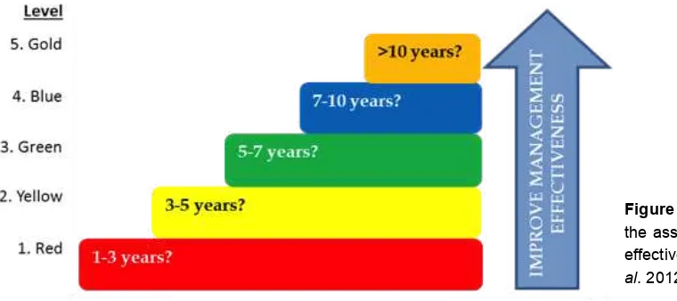
The Ministry of Marine Affairs and Fisheries has c o m p l e t e d a n d l e g a l i z e d a n M PA M a n a g e m e n t Effectiveness protocol (called “E-MPA”) as a standard for assessing MPA management status and performance. This assesses the effectiveness level of various aspects, including area management, ecological, socio-economic, cultural and governance, dividing into ive levels (Fig. 4):
1. Level-1 (Red): MPA is initiated, when baseline data are completed and a designation decree is released;
2. Level-2 (Yellow): MPA is established, when a management unit is established, a management plan is drafted, infrastructures development is started, and government budget is allocated;
3. Level-3 (Green): MPA is managed minimally, when management plan and zoning are legalized and start to be implemented, SOPs are developed, and infrastructures and equipment completed;
4. Level-4 (Blue): MPA is managed optimally, when MPA boundaries are legalized, management strategies on institutional strengthening, area/resources
management, and activities supporting socio-economic-culture conditions are implemented;
5. Level-5 (Gold): MPA is managed sustainably, when the measured impact of MPA is positive, and a sustainable financial strategy is developed and ready to be implemented.
Assessment of the MPA management effectiveness refers to the stage of development as outlined in the Ministerial regulations No. PER. 02/MEN/2009 on the Procedures for Determination of MPA and No. PER. 30/MEN/2010 on the
Figure 4. Building block principle for
Management Plan and Zoning of MPA. Based on these, the development and management of a MPA should proceed with completion of all required conditions in one stage before moving on to the next. The principle is commonly called a ‘building block principle’, as it requires all important and fundamental activities at one stage to be completed before ascending to the next management level.
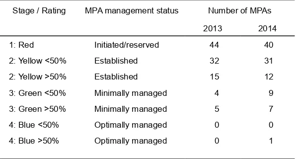
Results from E-MPA assessment exercises in 2013 and 2014 indicate that most of MPAs in Indonesia are still at the initiation stage (Table 6), having been just established and/ or being at the irst stage of developing management plans including zoning and management units.
Further effort to expand marine protected areas should include identification of candidates for new MPAs, with priorities given to outermost border regions and small islands that are prone to disintegration. Establishment of new MPAs in Indonesia’s outer islands could serve many
purposes, including national security and accelerating the development of local economies while eliminating illegal ishing and over-exploitation of resources.
Towards new paradigms of MPA management
Promotion of rational management of marine protected areas is linked to the following strategies: (1) protecting the environment through various conservation programs, (2) transforming the MPAs into an economic driver through marine ecotourism, sustainable isheries and self-sustaining financing, and (3) management of protected areas in a form of social responsibility that provides beneit to society. Thus, a new paradigm of MPA management under the MMAF is not just about protection and preservation. It
underscores the importance of MPA ‘utilization’ to benefit the society. Forms of utilization permissible in such areas include fisheries and aquaculture, travel/tourism, research and development, and other economic activities that are compatible with conservation principles. A point to note is that such utilization remains limited and priorities should be given to the sustainability of available resources.
A large number of stakeholders involved with different interests and roles in the management of MPAs necessitates a collaborative management (co-management) model that takes into account the uniqueness of each region and local contexts. This model should focus on the management level, not on the ownership of management authority. Collaborative management model is expected also to be in line with the co-management terms developed by IUCN
Stage / Rating MPA management status Number of MPAs
2013 2014
1: Red Initiated/reserved 44 40
2: Yellow <50% Established 32 31
2: Yellow >50% Established 15 12
3: Green <50% Minimally managed 4 9
3: Green >50% Minimally managed 5 7
4: Blue <50% Optimally managed 0 0
4: Blue >50% Optimally managed 0 1
Table 6. Results of E-MPA assessment in 2013/2014 (Dermawan et al. 2014)
(1996) where the government, local communities, NGOs and other stakeholders form an effective partnership for management. Understanding co-management with the same essence is defined by the World Bank (1999) as the share of responsibilities, rights and duties among key stakeholders, particularly local communities and governments.
district-based MPAs. As a follow up, Minister of the MMAF signed on June 2015 the Ministerial Regulation No. 21/ Permen-KP/2015 on partnership for MPA management. In order to promote sustainable financing for the management of MPAs, the MMAF established a multi-stakeholders working group in 2011. Members of the working group came from the MMAF, Ministry of Finance, Bappenas-Development and Planning Agency, the Ministry of Forestry, the Ministry of Environment, and international and local NGOs. The working group assessed inancial gaps in managing MPAs across Indonesia. This assessment was based on previous studies on the costs of MPA management and its minimum requirement as cited in the MMAF decree and current practices on the ground. In addition, the working group has been finalizing the development of a financing vehicle at national level in managing MPAs. This vehicle allows the involvement of stakeholders such as private sectors, the public, and donor agencies to provide resources to support MPA management. The working group inalized the design of the Trust Fund for Marine Conservation, its organizational structure and standard operating procedures. At the site level, MMAF promotes the establishment of
institutions and financing mechanisms to manage MPAs and the strengthening of local government’s management capacities. These include identifying new funding sources, e.g. local taxes, fees from visitors and cooperation with oil and gas companies which operate around MPA sites. These may lead to the implementation of public-service agency system as a local inancing vehicle.
Future prospects
There are a number of points that should be taken into consideration for further planning and development of management strategies concerning marine coastal environments in Indonesia:
• A participatory approach is needed in the development of an MPA. MPA development programs need community participation or public consultation as a key element in the approach. Public participation ensures that the local community has the opportunity to participate fully
from preparation processes to monitoring and evaluation stages. When they have a voice in the design process of an MPA including the formation of rules, then they will strongly support the next steps of management. In addition, broad participation also can more effectively resolve conlicting points of views among stakeholders. • Creating public trust in community-engagement as early as possible since the beginning of a program. The public will then be well informed of program objectives and more encouraged to participate. This can facilitate MPA establishment and effective MPA management.
• Recognizing local communities as partners in all activities and obtaining their viewpoints which can be integrated into program management. Such co-management or partnership is considered the best solution for smooth running and implementation of management programmes.
• Local wisdom/experiences in the management of marine resources which already exist in some communities
need to be appreciated and strengthened. Such local management systems are most eficient in the long-term. • Private sectors should be encouraged to participate in the planning and management of MPA. Many private sectors are potentially capable of furnishing financial assistance within CSR (Corporate Social Responsibility) programs.
• The success of an MPA cannot be separated from fund availability, as the planning and management of an MPA requires funding which should be considered as prior investment for bringing benefits to local communities in the future.
References
Birkeland C (ed) (1997) Life and Death of Coral Reefs. Chapman and Hall, London. 525 pp.
Bohnsack JA, Causey B, Crosby MP, Griffis RB, Hixon MA, Hourigan TF, Koltes KH, Maragos JE, Simons A and Tilmant JT (2000) A rationale for minimum 20-30% no-take protection. Proceeding of the 9th International Coral reef Symposium. 23-27 October 2000. Bali, Indonesia.
Burke L, Reytar K, Spalding K, and Perry A (2011). Reef at Risk: revisited. World Resource Institute. Washington DC, USA. 116 pp.
COREMAP [Coral Reef Rehabilitation and Management Project] (2014) Website: coremap.or.id
Claudet J, Pelletier D, Jouvenel JY, Bachet F dan Galzin R (2006) Assessing The Effects Of Marine Protected Area (MPA) On a Reef Fish assemblage In a Northwestern Mediterranean Marine Reserve : Identifying Community-Based Indicators. Perancis. Biological Conservation 130: 349-369.
Dahuri R (2003) Keanekaragaman Hayati Laut: Aset Pembangunan Berkelanjutan Indonesia. PT. Gramedia Pustaka Utama, Jakarta. 412 pp. (in Indonesian). Dermawan A, Suraji, Soemodinoto A, Sutraman and Susanto HA
(2014) Management Effectiveness of Marine Protected Areas in Indonesia: Progress and Present Status. World Park Congress, Sydney.
Dit. KKJI [Directorate for Area and Fish Species Conservation of the Ministry of Marine Affairs and Fisheries] (2012) Technical Guidelines for Evaluating the Management Effectiveness of Aquatic Coasts and Small Islands Conservation Areas (E-KKP3K). Jakarta. 61 pp.
Dit. KKJI (2014) Website: kkji.kp3k.kkp.go.id
Hinrichsen D (1997) Coral reef in crisis: An overview of these vanishing ecosystems. the problems that plague them. and the means for saving them. Bioscience 47 (9): 554-55
Hufard CL, Erdmann MV & Gunawan TRP (eds) (2012) G e o g r a p h i c P r i o r i t i e s f o r M a r i n e B i o d i v e r s i t y Conservation in Indonesia. Ministry of Marine Affairs and Fisheries and Marine Protected Areas Governance Program. Jakarta. 118 pp.
INCC CTI-CFF [Indonesia National Coordinating Committee Coral Triangle Initiative on Coral Reefs, Fisheries and Food Security] (2012) The State of the Coral Triangle in Indonesia. Jakarta. 189 pp.
Kelleher G (1999) Guidelines for Marine Protected Areas. Best Practice Protected Area Guidelines Series No. 3. Gland. Switzerland. International Union for Conservation of Nature (IUCN): and Cardiff, Wales, UK. Cardiff University.
Kementerian Kehutanan dan Kementerian Kelautan dan Perikanan [Ministry of Forestry and Ministry of Marine Affairs and Fisheries] (2010) Analisis Kesenjangan Keterwakilan Ekologis Kawasan Konservasi di Indonesia (A Gap Analysis of Ecological Conservation Representativeness in Indonesia). Kementerian Kehutanan dan Kementerian Kelautan dan Perikanan, Jakarta. (in Indonesian).
KLH [State Ministry of Environment] (2008) Status Lingkungan Hidup Indonesia 2008. Jakarta. (in Indonesian).
McAllister DE, Schueler FW, Roberts CM & Hawkins JP (1994) Mapping and GIS analysis of the global distribution of coral reef fishes on an equal-area grid. In: Mapping the Diversity of Nature (edited by R.I. Miller). Chapman and Hall, London.
McLeod E, Salm R, Green A & Almany J (2008) Designing marine protected area networks to address the impacts of climate change. Frontiers in Ecology and the Environment, 7:362-370.
Mulyana Y & Dermawan A (2008) Konservasi Kawasan P e r a i r a n I n d o n e s i a b a g i M a s a D e p a n D u n i a (Indonesian Marine Protected Areas for Future World). Direktorat Konservasi Kawasan dan Jenis Ikan. Kementerian Kelautan dan Perikanan (Directorate of Conservation for Area and Fish Species. Ministry of Marine Affairs and Fisheries), Jakarta. (in Indonesian) Mustika, P. L., Gunawan, T. & Erdmann, M. V. (eds) (2013) A
Marine Rapid Assessment (MRAP) of the Anambas Islands Marine Tourism Park, 3-31 May 2012, Ministry of Marine Affairs and Fisheries, Indonesian Institute of Science (LIPI), the Government of Anambas Regency, The Nature Conservancy, Conservation International Indonesia, Denpasar. 143 pp.
Nontji A (2002) Coral reefs of Indonesia: past. present and future. Proceeding 9th International Coral Reef Symposium (Bali, Indonesia, 23-27 October 2002) 1, 17-27.
PISCO [Partnership for the Interdisciplinary Study of Coastal Oceans] (2002) The Science of marine reserves. www. piscoweb.org.
Salm R, Clark JR & Siirila E (2000) Marine and Coastal Protected Areas: A guide for planners and managers. 3rd edition. IUCN. Gland. Switzerland.
Satria A, Sano M & Shima H (2006) Politics of marine conservation area in Indonesia: from centralized to a decentralized system. Int.J. Environment and Sustainable Development. Vol.5 No. 3: 240 - 261. Suharsono (2009) Overview of the successful of coral reef
management and coral condition in Indonesia. Paper presented at the International Symposium on Ocean Science, Technology and Policy. World Ocean Conference. May 11-15 2009. Manado, Indonesia. Suraji, Basuki R, Soemodinoto A & Susanto HA (2012) Menuju
Pengelolaan Efektif Kawasan Konservasi Perairan di Indonesia: Metode Evaluasi Efektivitas Kawasan Konservasi Perairan. Pesisir dan Pulau-pulau Kecil (E-KKP3K). Proceding Konferensi Nasional Pengelolaan Pesisir. Laut. dan Pulau-pulau Kecil. Oktober 22-24. 2012. Mataram. Indonesia. (in Indonesian).
Susanto HA (2011) Progres Pengembangan Sistem Kawasan Konservasi Perairan Indonesia : A Consultancy Report. Kerjasama Kementerian Kelautan dan Perikanan dengan Coral Triangle Support Partnership (CTSP), Jakarta. (in Indonesian).
Published: 25 December 2015
United Nations Environment Program (UNEP) and World Conservation Monitoring Centre (WCMC). (2008) Establishing National and Regional Networks of MPAs— A Review of Progress with Lessons Learned. UNEP and WCMC, draft report, 106 p.
Veron JEN (2001) Interpretation of the biogeographic classiication. Report to the Nature Conservancy. 10 pp + map.