Submitted in Partial Fulfilment
International Master Program
Graduate
(In Collaboration between Sriwijaya
FACULTY OF TEAC
SRIWIJAYA
A THESIS
Fulfilment of the Requirements for the Degree
Master of Science (M.Sc)
in
Program on Mathematics Education (IMPoME)
Graduate School Sriwijaya University
Sriwijaya University and Utrecht University)
By:
Elika Kurniadi
NIM. 20112812002
Universiteit Utrecht
TEACHER TRAINING AND EDUCATION
SRIWIJAYA UNIVERSITY
JUNE 2013
Degree of
(IMPoME)
1
Most people frequently face spatial problems in their daily life. Spatial forms can be represented in pictures or diagrams which are useful for communicating ideas. A picture is a kind of representation of spatial ideas such as a geometrical drawing, maps, plans, etc. Young children have many spatial experiences with their environment, especially through the sense of sight and touch (Dickson, 1984). The spatial experience starts before the development of language. Spatial matters are involved in learning and teaching mathematics as a representation of the real world. Lowrie (2010) suggested that students need spatial ability that allows them to consider all the elements of a task, including specific features of a graph and the surrounding text, when solving a mathematical task.
Clarke (2003) stated that maps are the main source of spatial information and spatial ability which is required to decode maps because of the spatial relation among visual elements. Many tools and instructional devices can help children to develop and organize their own thinking in map understanding. A map is such a kind of representation in graphic form. Therefore, a map can be a bridge between the real world and abstract world. In addition, it might help children to understand the other graphs in mathematics and science. Liben (2008) asserted that students in elementary school have a basic understanding of maps.
spatial ability. For instance, persons with better spatial visualization can interpret map content properly. Moreover, persons with better spatial orientation are able to compare map content to the surrounding environment (Rusch, 2008). However, according to the result of Diezman & Lowrie’s study (2007) reported that 10-13 year old children have difficulty to understand the information in maps. Therefore, it is necessary to bring the students in the class into the map reading activities
Likewise, many educators do not give attention to map understanding and sometimes high jump to an abstract level in mapmaking and map reading. Drawing is a process that allows children to figure out the representation emotionally in their thinking (Sobel, 1998). Children can start the reading and writing process by telling stories, drawing a picture of the story, and writing the story in their own words. It is important for children to draw in the beginning of the process of mapmaking.
4 2.1 Spatial Ability
A Spatial ability is an ability that consist of declarative and perceptual forms of
knowledge to transform, manipulate, combine and operate information presented
in a visual, diagrammatic or symbolic form (Lohman, et al, 1987; Hegarty &
Kozhevnikov, 1999). Spatial ability can be used in particular representation and
reasoning include diagrams, drawings, maps, and models. The three important
elements of spatial ability are concept of space, tools of representation, and
process of reasoning (National Research Council, 2006, p.12-13).
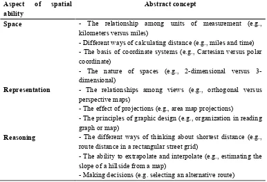
Table 2.1
A general description of spatial ability Aspect of spatial
ability
Abstract concept
Space - The relationship among units of measurement (e.g., kilometers versus miles)
- Different ways of calculating distance (e.g., miles and time) - The basis of coordinate systems (e.g., Cartesian versus polar coordinate)
- The nature of spaces (e.g., 2-dimensional versus 3-dimensional)
Representation - The relationships among views (e.g., orthogonal versus perspective maps)
- The effect of projections (e.g., area map projections)
- The principles of graphic design (e.g., organization in reading graph or map)
Reasoning - The different ways of thinking about shortest distance (e.g., route distance in a rectangular street grid)
- The ability to extrapolate and interpolate (e.g., estimating the slope of a hillside from a map)
Grattoni (2007) found that students’ practice spatial abilities would improve
their math ability. Although, that study was in small participant, the finding is
similar to another study (Hegarty & Kozhevnikov, 1999) that showed spatial
representation could promote problem solving success. It seems that spatial skills
play an important role in solving certain kinds of mathematical problem solving.
For example, the problem from calculus and geometry often explore the relation
between time and area.
Lowrie (2010) suggest that students need to get spatial ability that allow them
to consider all the elements of a task, including specific features of a graphic and
the surrounding text, when solving mathematical task. Elementary students’
spatial thinking improves more over the school year (Newcombe, 2010). A recent
meta-analysis showed substantial improvements in spatial skill from wide variety
of interventions, including academic coursework, task-specific practice, and
playing computer games that need spatial thinking. Clarke (2003) stated that maps
are the main source of spatial information and spatial ability is required to decode
maps because of the spatial relation among visual elements. Therefore, the present
study has intention to develop children’s spatial ability through learning by using
a map.
2.2 The Development of Spatial Ability
Piaget and Inhelder (1967) defined three stages in the development of spatial
ability: (1) Preoperational stage is started from egocentric children to locate
understand limited topological spatial relationships. (2) Concrete operational stage
occurs between seven to nine years old. They develop a cognitive map with a
fixed frame that allows them to imagine and orient their body. Children also
develop more complex understanding about external frame of topological relation
such as left/right. (3) Formal operational stage is begun around 11 years old.
Children develop an understanding of Euclidian spatial relation such as estimating
distance.
Particularly, the present study is related to the map understanding which is
closely to the spatial orientation. Therefore, we also focus on the developmental
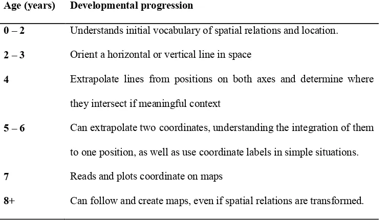
progression in spatial orientation (Clements & Sarama, 2009):
Table 2.2
The developmental progression in spatial orientation Age (years) Developmental progression
0 – 2 Understands initial vocabulary of spatial relations and location.
2 – 3 Orient a horizontal or vertical line in space
4 Extrapolate lines from positions on both axes and determine where
they intersect if meaningful context
5 – 6 Can extrapolate two coordinates, understanding the integration of them
to one position, as well as use coordinate labels in simple situations.
7 Reads and plots coordinate on maps
The participant of the research is that second graders in primary school. It
means that we focus on the concrete operational stage in spatial ability. In
designing activity in the classroom, we consider the developmental progression at
7 to 8 years old.
The better approach for mapping experience is in visual, kinesthetic, and
emotional. However, many educators do not attention with those and sometimes
do high jump to abstract level in mapmaking and map reading. Children start the
reading and writing process by telling stories, drawing a picture of story, and
writing the story in their own words. It is important for children to draw in the
beginning process in mapmaking. Drawing is a process that allows children to
figure out the representation emotionally in their thinking. Children’s map
represents their experience of beauty, secrecy, adventure and comfort. The
development of emotional bonds and cognitive skill needs to go hand in
appropriate approach. The progression of children’s mapmaking is microcosm of
cognitive development in elementary school (Sobel, 1998). Considering the
development cognitive of children in every level age and phase thinking, it
addresses about the phase of children thinking for each two level age, from five
until twelve ages. Each phase of thinking is related to some appropriate context of
map for each level age children. For instance, five and six year old children are
familiar with context related to their home and neighborhood. Asking first graders
2.3 Map Understanding
In general, maps are visual representation/graphic data where information is
encoded through the spatial location of fixed position marks (Mackinlay, 1999). It
is necessary to deal with understanding the map. Wiegand (2006) stated five types
of fundamental knowledge to well understand a map:
a) Understanding that map represent space
b) Understanding the alignment and perspective of the map
c) Understanding scale
d) Understanding symbols and texts
e) Using maps to find the way
The representation of mathematical ideas, concepts, and relationship in
graphical form is common in mathematics. Graphic include graph, maps,
diagrams, hierarchies and network. Liben (2008) stated that students in
elementary have basic understanding about map. Developing this understanding is
notable to increase the ability in reading maps properly because according to the
result of Diezman&Lowrie’s study (2007) is that 10-13 year old has difficulty
with the information in maps to understand it. In the last five years, Diezman and
Lowrie have explored how students interpret the mathematical graphic including
maps with their own structure and spatial arrangement.
The model of map understanding is in line with how our brain arranges
knowledge and spatial process. Many tools and instructional devices can help
such a kind of representation in graphic form. Therefore, a map can be a bridge
between the real world and abstract world and help children to prepare
understanding the other graphs in mathematics and science. Based on cognitive
perspective, an increased emphasis on map understanding will enhance the
objective of greater mathematical and scientific literacy.
2.4 Spatial skills and maps for children
In the classroom, teaching and learning are limited and fail to connect map skills
with other curriculum areas, including mathematics. Most students do not have
ability and understanding to use map even. Moreover, many of young children get
difficulty and misunderstanding about space that is conflict between sensory
concrete and abstract frames of reference. Therefore, Clement (2009) suggested
that it is important to guide children to:
a. Develop abilities to build relationship among objects in space.
b. Extend the size of that space
c. Link primary and secondary meaning and uses of spatial information
d. Develop mental rotation abilities
e. Go beyond map skills to engage in actual use of maps in local environment
f. Develop an understanding of the mathematics of maps.
Children need to learn about model and maps including incidental and planned
experience such as frequent discussion about spatial relation, finding a missing
object, and finding the way back home. Teacher should provide instruction on
generating four mathematical question (Clements & Sarama, 2009): (1) Which
way (direction), (2) How far (distance), (3) Where (location), (4) What objects
(identification). Children must learn about mapping process and more
sophisticated ideas of direction and location. In addition, they should develop
navigation ideas, such as left, right, front, back, etc. Then, they might represent
these ideas in simple route maps within the classroom.
Therefore, a specific experience with map can help students to get more
understanding about map. For instance, the present study will encourage children
to work with model animals to build maps of the zoo with these models. Children
might use cut out shapes of animals, trees, and sandbox in the playground and lay
them out on a felt board as a simple map. These are good starting situation.
Models and maps should eventually move beyond simple iconic picture and
challenge children to connect the abstract and sensory-concrete meanings of maps
symbols. Introducing such situation can evoke geometric correspondences.
Realistic Mathematics Education in geometry makes extensive use of interesting
spatial and map tasks (Gravemeijer, 1990), but unfortunately, research on the
effects of this specific strand is lacking.
2.5 Realistic Mathematic Education (RME)
RME is the domain specific instruction theory that offers a framework for
interpreting students’ activity in learning mathematics (Gravemeijer, 1994).
According Freudenthal’s view, two important points in learning mathematics are
mathematics realistic, the teachers should consider to the mathematizing which is
a process to interpret, organize, and construct meaning of situation with
mathematical modeling. The mathematizing involves the spatial relationship
(Gravemeijer, 1994). The present study considers the spatial aspect in
mathematics through a learning map. We design Hypothetical Learning Trajectory
(HLT) for supporting students’ development of map understanding particularly
spatial ability aspect. The design influenced by five characteristic of RME
(Treffers, 1987, cited in Zulkardi, 2002) as described follow:
a. Use of contextual problem
The real and meaningful context is important thing for students as a
starting point for learning process. In this design, the context of map
provides students to develop their spatial ability. The problem about map
allows students to realize what are they doing and generate some
questions, wonder, and critical thinking, such as why and what if.
b. Use of Model
This design used a map as a representation of model between the real
worlds to the abstract world. Map is kind of geometric model in
mathematics.
c. Use of students’ contribution
The series of instructional activity consider the opportunity to students in
contributing their own informal problem solving strategies. The activity of
map reading offers the students to use their previous experience about
d. Interactivity
Students’ interaction enhances justification agreement and reflection on
the work (Gravemeijer, 1994). During the learning process, students will
be encouraged in classroom discussion, such as gallery poster session will
prompt students to discuss the map that their produce in mapmaking
activity as a part of the design.
e. Intertwining of learning strands
Map skills as the topic of the design is related to the spatial aspects in
mathematics closely to build geometric building visualization. In addition,
this topic also intertwine with geography lesson particularly map reading.
It shows that the connection to other subjects is more meaningful in real
world.
2.5 Map reading in Indonesian curriculum
The topic of map activity in Indonesian curriculum is firstly introduced as a part
of social subject for elementary students. The table below describes topic of map
for grade 1 in Indonesia curriculum (Depdiknas, 2006).
Table 2.3
Map topic in Indonesia curriculum The second Semester of Grade 1
Standard Competence Basic Competence
2. Describe the neighborhood 2.1 Tell the important experience around
2.2 Describe the position of the
neighbourhood.
It is not common in Indonesia to learn about map activity as a part of teaching
and learning mathematics in the school. It shows less emphasis to consider the
map understanding as a part of spatial ability aspect in mathematics classroom.
Therefore, the present study would like to focus on the process of how students
understand the maps to support the development of spatial ability in mathematics
classroom.
2.6 Present study
In the previous study of Shintia’s thesis, it considers about spatial ability
especially spatial visualization. That study provided some activities that are in line
Pendidikan Matematika Realistik Indonesia (PMRI). The study found that spatial
visualization task can support students spatial structuring in learning volume
measurement. The present study is also related to the spatial ability, we provide
the activity of map which is following the characteristic of PMRI. The activity of
map is such learning process by using maps to support the development of spatial
ability. The hypothesis of this study is that the activities of map can help children
to develop their spatial ability. Related to the hypothesis, the researcher
The research question is focused on the role of the map activities in supporting
children’s learning. The study investigated the influence of the instructional
sequence of map activity on the development of students’ spatial ability. The
components of the instructional setting can contribute to supportive map activity.
The analysis is emphasized to a better understanding of the complexity of such an
instructional setting and its influence on the development of students’ spatial
15 3.1 Research approach
The purpose of the present study is to contribute the local instruction theory of
spatial ability particularly map reading. The study focuses on the general research
question: How can map activities support the development of spatial ability?The
activity of map is such learning process by using maps to support the development
of spatial ability. This implies that the researchers need to design an instructional
sequence of map activity and research how the design supports students to reach
particular end goals. Therefore, the approach of present study used design
research because it considers design as a crucial part of the research. The main
reason of use design research is to develop Hypothetical Learning Trajectory
(HLT) together with instructional material and to contribute the local domain
theory of Realistic Mathematic Education (RME) especially in spatial aspects.
The main result of design research is not a design that works, but the reason why,
how, and to what extent it works. Therefore, a design research is evaluated as an
innovation and improvisation that are useful in educational practice because it is
grounding in experience and developing in practice to generate empirically
3.2 Data collection
3.2.1 Preparation phase
In this phase, the researcher collected some various data to get some information
as a starting point of the research. The data of preparation phase is described as
following:
a. Classroom observation
The researcher observed the class experiment before doing the teaching
experiment. The purpose of classroom observation is to know :(a) the
culture of classroom, (b) teacher’s and students’ activity, and (c) the
interaction between teacher and students during teaching and learning
process. The researcher took video recording and field notes during
classroom observation. The classroom observation will be guided by the
list topic in scheme of observation (appendix 1).
b. Interview with the teacher
Interview with the teacher was conducted after the classroom observation.
The aim of interview is to know the teaching and learning process from the
teacher’s perspective and to clarify the data of classroom observation. The
interview will be guided by the list topic in scheme of interview (appendix
2). Furthermore, the interview was recorded in audio recording and be
backed up by making field notes.
3.2.2 Preliminary teaching experiment (first cycle)
The first cycle of design was conducted in small group consist of 5 students grade
teaching and learning process was recorded in the video recording. In addition, the
researcher collected the written work of student and conduct mini interview to
know the response of students’ thinking about the content of the design.
Therefore, the purpose of the first cycle is as a pilot study to test the conjectures
and improve the design and also as a discussion with the teacher who will
implement the design in the second cycle.
3.2.3 Teaching experiment (second cycle)
The second cycle of the design was held in one class of grade 2 in Indonesia
elementary school. The teacher implemented the revision of design according the
result in the first cycle (appendix 3). In this phase, the researcher has two focus
group consists of 2 students who are in the middle level of achievement. During
the teaching and learning process, the researcher collected the data of video
recording by using one static camera that focus on the work of focus group and
one dynamic camera that record classroom activities. Some interesting fragments
of video were chosen to be transcribed and analysed in retrospective analysis. The
researcher also took field notes for teaching and learning process. In addition, the
written works of students were collected to know students’ thinking during the
teaching and learning process. Field notes and copies of students’ written work are
additional data sources.
3.2.4 Pre-test and Post-test
- Pre-test
To assess the pre-knowledge of the students’ thinking and achievement
participant of pre-test is all of student in the teaching experiment class and
students worked individually. In the pre-test, there are some problems
related to map understanding and spatial ability as a topic of the research.
- Post-test
Similarly, the post-test was given to students of teaching experiment class
to know the students’ achievement after teaching experiment phase.
Students solved some problems about map understanding and spatial
ability.
3.2.5 Validity and reliability
The validity and the reliability from the result of the research can be
considered as the quality of the research. In this research, the validity and
reliability were regarded from the two ways which are internal and
external:
a. Internal validity is mostly related to the quality of data collection. In
this issue, the present study considers about the various data such as
interview, observation, and video recording which lead to the data
triangulation. The validity of finding can be checked by using different
source of information. For instance, considering the type of data, the
researcher makes efforts to corroborate the interview data with the
other sources of information, such as observation and field notes that
b. External validity refers to generalizability of the result from the
specific contexts to other contexts. An important way to do so is by
framing issues in more general.
c. Internal reliability refers to the reliability within a research. We
consider the data from video recording to improve the internal
reliability. The selective fragment of video recording will account to
the reasonableness and argumentative power of inferences and
assertions.
d. External reliability refers to the track ability. The research must be
clear in such a way the reader can track the learning process and
reconstruct the study.
3.3 Data analysis
3.3.1 Preparation phase
a. Classroom observation and interview with teacher
The selected fragment of the data classroom observation and teacher
interview was transcribed and analyzed. Observation and interview criteria
are analyzed to find out the description about classroom culture between
students’ and teacher’s interaction each other’s. These observation criteria
are defined in terms of both verbal and nonverbal behaviors. Therefore, the
result of those analyses will be used to get the insight into the context
b. Pre-test
In analyzing the result of pre-test, the focus is on the strategy that students
use to solve the problem about map in the written test. The analysis will be
done in quantitative and qualitative analysis. The students’ solution to
each of the problem were investigated and identified as a particular level
of students’ spatial ability. The results of pre-test takes account into a
starting point of students’ thinking in HLT and contribute to insight of a
developmental trajectory for students’ spatial ability.
3.3.2 Preliminary teaching experiment (first cycle)
During preliminary teaching experiment in small group, the selected
fragment from video recording and interview with students was
transcribed and analyzed to consider the content of HLT. The reflection
after the preliminary teaching experiment led to adapting the conjectures
and the teaching sequence, which became the starting point for a teaching
experiment in the second cycle. This cyclic process aimed both at
empirically grounded answers to hypothesis concerning the research
question and at a conjectures local instruction theory. Changes in HLT are
purposed to create optimal condition in the second cycle. In addition, the
pre-test and post-test that is given in the first cycle were analyzed to know
students’ thinking and achievement in quantitative and qualitative
analysis. Therefore, the results of first cycle were used to revise the HLT
since it shapes the idea about activities, the level of students and the
3.3.3 Teaching experiment (second cycle)
The data collection during the teaching experiments varied. The researcher
collected students’ work, field notes, and video recording of every lesson.
The researcher analyzed the data of pre-test and post-test in the second
cycle. Moreover, some interesting students’ work was selected to figure
out how students solve the problem and to be used for testing the
conjectures in HLT. The field notes are written up into lesson reports
which identify the important episodes from classroom discussion to the
particular students in the learning process of all lessons. In addition, the
researcher watched the video registrations of each lesson and transcribed
the transcript of the interesting fragment video. It is used to describe the
group discussion or the classroom discussion and to analyze the students’
contribution. The results of the analysis were regarded to draw the
conclusions, to answer the research question and to revise the HLT.
3.3.4 Post-test
The researcher need to analyze the result of pre-test to investigate what
extent students had reached the learning goal after the teaching
experiment. The result of post-test was analyzed in quantitative and
qualitative analysis. The researcher will compare the result between the
3.3.5 Validity and reliability
During retrospective analysis phase, the researcher discussed with
supervisors. The discussion can support the validity and reliability of the
data analysis.
a. Internal validity: the different source of data which is data
triangulation was used in data analysis. During the analysis, the
researcher tested conjectures that are generated at specific episode
from different data material such as fields’ notes, tests, and students’
works.
b. External validity concerns to the results of HLT on generalizability of
the conclusion presented in such a way that other researcher can adjust
them to their own local settings.
c. Internal reliability refers to the discussion with others to interpret the
data and draw the conclusions.
d. External reliability emphasis on the track ability. The teaching
experiments and data analysis were guided by the conjectures of HLT.
The researcher describe this process systematically in such a way it
offered other researchers the possibility to replicate the learning
process and draw the same conclusion through the cycles of teaching
23
A HLT is a framework of learning activity that consists of learning goal, starting
point, mathematical learning, and conjecture of students’ thinking. In this chapter,
we elaborated HLT that involve 5 activities in a learning sequence of map
understanding related to the spatial thinking particularly spatial orientation.
Spatial orientation is one of the main component of spatial ability that allows
children to learn about orientating themselves, to take different perspective, to
describe routes, to understand the shape/figure and realize the spatial relationship
between objects (van Nes & de Lange, 2007).These activity emphasize the three
mathematical question that is related to the map problem (Clements & Samara,
2009) are (1) Which way? (direction), (2) Where? (location), and (3)What
objects? (Identification). The development of the children’s thinking is started
from map reading to map making followed by communication in using a map.
Therefore, the first activity is about map reading of school map and the last
activity is map making from a miniature zoo.
4.1 Lesson 1 : Read a school map
Learning goal
Students understand their own school map
map.
Starting point
Students recognize the shape square as a room on the map.
Students realize position of their class on the map.
Classroom culture
1. Teacher asks students to raise their hand if students want to ask question.
2. Teacher encourages students to tell their opinion.
3. Teacher will raise her hand as a sign to silent.
4. Students should work in team work.
Description activity
This activity offers the experience of map reading for students to do activity by
using a school map to find the certain room on it. Students should realize the
position of the room on the map and follow the path. Also, this activity provide
opportunity for students to understand the symbol or pictorial figure on the map
1. Introduce the school map and tell the problem
go from Kelas II to UKS (School health program) room for taking the first aid
box. They will find that room based on the given map.
Students’ conjecture
Students will use a school map to find UKS room.
They will work in group of 4 to discuss about what they understand and
interpret the map. For example, where is their position on the map? Or the
meaning of pictorial figures on the map.
Later, they will discuss about the way to go UKS room.
A few groups might have different way to find the way of UKS room.
2. Teacher generates the discussion about:
a. Is it easy to find UKS room?
b. How do students understand about the map?
c. How do students find the UKS room?
d. What are the rooms that they pass during the way to UKS?
3. Teacher compares which group is the fastest and the slowest group that find
UKS room.
4. The fastest and the slowest group talk their experience by using a map.
Students’ conjecture
Students can read a map easily because they recognize the position of the
object in the map to the real condition.
Students who can read a map easily will follow the path in the map to find
Students have difficulty to realize the position in the starting point.
Students get lost when they follow the school map to find the room.
5. Closing the lesson
Teacher reflects the lesson by asking some questions:
What do we learn?
What is the important to learn about read a map?
What is your strategy to read a map easily?
4.2 Lesson 2 : Left Versus Right
Learning goal
Students understand about the term of orientation, such as forward, go
back, left and right.
Students are able to distinguish between left and right.
Students can find the position of certain object by using orientation term.
Starting point
Students have already heard about the term of orientation.
Students have already known the position of objects.
Description activity
In the previous activity, students have already experience outside about finding
the room. They realize the position of the rooms in the school map. In this
term of orientation. Therefore, this activity encourage student to realize about the
orientation.
Before discuss about classroom map, students have a little experience to move
their body by simple instruction of orientation.
1. Classroom experience
In the beginning activity, teacher asks students about the term of
orientation:
Have you ever heard about go forward/go back/turn the left/turn
the right?
Can you give me the example of direction sentence of certain
object?
Where does student A sit?
In this activity, students do it outside the class. Students have experience by
moving their body according the instruction from the teacher, such as:
a. Turn the left
b. Turn the right
c. Go forward 3 steps
d. Go back 2 steps
This activity be held for all students in the class during 5 minutes.
Students’ conjecture:
1. Some students move correctly based on the instruction, especially go
Teacher’s Action
Teacher tells the students who have difficulty to follow their friend’s
movement in turning the left or right.
2. Classroom discussion
There is a classroom discussion after they have experience on moving their
body. Topic discussion:
1. Why can some students not distinguish between left and right?
2. How do students distinguish between left and right?
3. Can you tell your way to do it?
Student’s conjecture:
a. Some students consider their hand as the sign, such as right hand to
write, so another hand is left hand.
b. Use the position of object, such as a watch is on the left hand side.
3. Work about classroom map in group
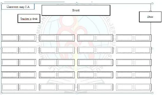
Teacher said that she needs students’ help to make a classroom map to
Figure 4.2Classroom map
4. After they finish work on classroom map, teacher asks students to look the
classroom map that they have done and realize the position of some
students, here are some question about students’ position on the classroom
map such as
a. Who does sit on the right of student A?
b. Who does sit on the left of student B?
c. Who does sit behind of student C?
d. Who does sit in front of student D?
e. Who does sit on the two steps to the right of student E?
f. Who does sit on the three steps to the left of student F?
g. Who does sit on the two steps to the forward of the student G?
h. Who does sit on the two steps behind of student H?
i. Who does sit on the three steps to the right and two steps forward of
Students answer in the paper A4 for each question and show the answer. It
can generate the classroom discussion whether students answer correctly
or not about how they answer the question according to the instruction on
the question.
5. Closing the lesson
Teacher reflects the lesson by asking some questions:
What do we learn?
What is the important to learn about directional term such as left,
right, forward, and go back?
What is your strategy to distinguish left side and right side?
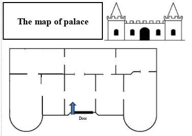
4.3 Lesson 3 : The map of palace
Learning goal
Students get better understanding about direction.
Students learn about simple navigation.
Starting point
Student are able to use and distinguish the left and the right side.
Description activity:
In the previous activity, students have already learned and about the term of
puppet to help them follow the direction.
Story: The king will tell you the room of palace. However, there is a blank map
and you have to fill the name of the room. By using the puppet, you will enter the
palace and give the name of the room on the map.
Figure 4.3The map of palace
1. Students play a navigational game. In this game, teacher gives
direction for the students to fill the name of the room on the map
of palace
Door
Figure 4.4. The instruction
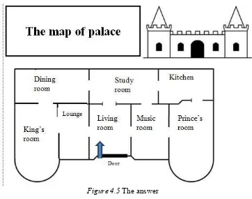
2. Students put their map of the palace on the white board.
The Answer:
Figure 4.5 The answer
3. Students look the others’ map and find the differences. Then,
teacher can generate classroom discussion:
Is there a different map?
Why is it different?
4. Classroom discussion
Students’ conjecture:
a. There is a different map because students write the name of
the room in the wrong place. It is caused of wrong
orientation (i.e. left and right).
b. It must be consistent with the direction.
c. It must be in the same direction view.
Teacher’s action:
Teacher asks about the possibility to have a such condition:
(Lounge is in the left of living room).
Lounge Living
room
Lounge
4.4 Lesson 4 : The Puzzle of Map
Learning goal
Students get better understanding about identification.
Students make a simple route in finding the way.
Starting point
Description activity:
In the previous activity, students are able to understand the direction by using the
orientation term. For this activity, students identify the object by realizing the
position of animal whether it is on the left or right side. Students use such a
puppet for help them to imagine the real situation in the previous activity, but in
this activity, students do not use puppet, so they have to keep hold the left side
and the right side of the turtle.
In the beginning of activity, students work on the puzzle. They have a little
discussion about how to arrange the puzzle. Indeed, students need to identify the
pieces of puzzle in arranging the puzzle.
1. Teacher tells the story about the sea world.
2. Teacher introduce the problem
The first problem: What are the sea animal on the puzzle?
3. Students must arrange the puzzle to answer the first problem.
4. After students answer question about the animals on the puzzle. Teacher
asks students How they arrange and finish the puzzle.
Students’ conjecture:
a. Students do it by trial and error.
b. Students consider imperfect picture on the edge for the each part of the
puzzle.
c. Students find the corner part of the whole puzzle to start the arranging
of puzzle.
5. Next, Teacher tells the story of the turtle on the puzzle.
The second problem:Help the turtle to find his friends?
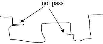
6. Students work in the group to draw the route of the turtle.
Students’ response:
a. Students make the way that is only passed by the turtle
Figure 4.7 Students’ response 1
b. Students make all the bend of the way although it is not passed by the
turtle
not pass
7. Students write the name of the animals that is met by turtle during his way
to find his friend. It will encourage students to consider about the other
objects on the path and put them in the proper location.
Figure 4.9Students’ response 3
8. Students will determine the position of the other animal according to the
left and right side of the turtle. Based on the second and third activity,
students are able to recognize the position of the certain object through
considering the left and right side.
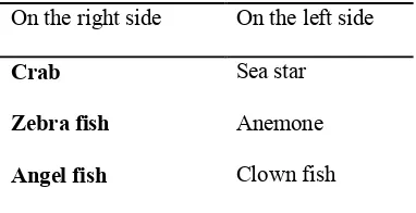
Students’ conjecture:
a. Students will answer correctly
On the left side On the right side
Crab Sea star
Zebra fish Anemone
Angel fish Clown fish
b. Students will answer in reverse way which is incorrect answer.
On the right side On the left side
4.5 Lesson 5 : The zoo map
Learning goal
Students realize the position of the objects.
Students can communicate and give the direction to find certain
object
Students make a simple map
Starting point
Students understand about orientation and direction.
Description activity:
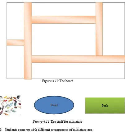
In the beginning of activity, students will create the miniature zoo. This zoo be
used as a representation of the place that will be explored .In the previous activity,
students have ability about orientation and direction. In this activity, students are
encouraged to communicate the idea of orientation and direction through guiding
their friend in finding the way of animal in the zoo.
1. Teacher asks students to have a role play as an owner of the new zoo.
Students will make a good arrangement of some animals, pond, and parks
in the zoo.
2. Students work in group. Students arrange the miniature of the zoo on the
Figure 4.10 The board
Figure 4.11 The stuff for miniature
3. Students come up with different arrangement of miniature zoo.
4. Students can explore their miniature zoo.
Students’ conjecture:
Students explain the arrangement of their own zoo.
Students can start to illustrate the position of the animals from the
gate of zoo. For example, the position of tiger is on the right side of
lion
Students use the direction and orientation knowledge from the
previous lesson to figure out the position of the objects. It means
that students have to communicate by giving the correct direction.
5. The miniature of zoo is a kind of representation 3-dimensional place. Next,
students deal with 2-dimensional place.
6. Students take the animals and other stuffs from the board and just write
down those things on the board. For instance,
Figure 4.12Students’ answer
7. Next, teacher tells to the students that as an owner of the zoo, they have to
make a map for the visitors in the zoo. Students will make a simple map of
their zoo on the worksheet.
8. Students explain their map to other friend (as the visitor) who has different
arrangement. Students should communicate their map clearly. Tiger
Cow
Park
Horse
Pond
Gate
Lion
CHAPTER V
TESTING HLT
In this chapter, we analyzed the whole data that were collected from preparation phase until teaching experiment. The teaching experiment in the first and second cycle was accomplished in Madrasah Ibtidaiyah Negeri 2 Model Palembang. To investigate and explain students’ thinking about the map activities in supporting the development of spatial ability, the hypothetical learning trajectory is used as a guideline in the retrospective analysis. Thereafter, the analysis process is focused in detail with attention to research question and how the design works.
5.1 Analysis of the teaching experiment for the first cycle
In this phase, the researcher worked with 5 students as participants who have different level thinking in mathematics. They are the high achiever students (Bagus and Bima), the average students (Farhan) , and the low achiever students (Fadli and Farraz ). The response of students in the first cycle of teaching experiment would give us feedback to improve the hypothetical learning trajectory for teaching experiment in the second cycle.
5.1.1 Pre Test
of 4 questions meanwhile the oral test is only one question about students’ communication which is asking students to tell their own map to other friends.
For the first question in the written test, it is purposed to know how student can memorize the position and location of the object from the certain map (Figure 5.1). However, some students are not patient to open the next page, and start to answer the question or open again the previous page to see the location object so it seemed that they do not memorize the position and location of the object while it is the purpose of this question. Therefore, all of students could answer the question correctly. The result of this question could not use to be analyzed in understanding the prior knowledge of students about memorizing the location of object.
Figure 5.1. The first question of pre test
Figure 5.2. The second question of pre test
Some of students use their hand to answer the question. They attempted to compare between the figure of the hand and their hand directly. The result shows that some students can answer it correctly and only a few of them cannot distinguish that picture whether it is left or right hand.
The purpose of the third question is to know how students determine the location of particular object after it moves according to the direction. For the last sub question about description of an object, all of students did not have an idea and misunderstanding about that question so the students cannot answer properly. In addition, some of students could not get the right perspective of the object in the question. Therefore, this question should be revised. It is necessary to put the perspective sign in this question.
instance, students draw shop, office, or trees. The purpose of the question in this part is not only asking students to make a simple map but also students have to communicate their map to their friend. They attempted to give the direction and shown the map to their friend. Only Bagus and Farhan can communicate their map fluently. It seems that other students still struggle to give direction and communicate their map for others.
Table 5.1
The result of the pre test in the first cycle
No Name Question
Number 1 Number 2 Number 3
1 2 3 1 2 3 4 5 6 1 2 3 4
1. Farhan - -
2. Bima - - - - -
3. Fadil - - -
-4. Farrraz - - - - - -
5. Bagus
is about direction. The result show that some students still did mistake even one or two sub-question.
5.1.2 Activity 1: The school map
The main purpose of the first activity in this lesson sequence is to provide an experience in reading a school map. According to the initial HLT in the chapter 4, there is a problem about finding the UKS (School health program) room and taking the first aid box there. The school map is given as a tool to find out that room. However, in the pilot experiment, the UKS room is near to students’ class. It seems that students do not need a map to find it because they have already known the position of UKS. Then, the researcher changed the problem into finding a star in a certain place and students have to read a map to know the location of the star.
In addition, related to another mathematical question on the map about what object (identification), students could explain the pictorial figure on the map, such as rectangle as a representation of the class. Understanding the pictorial figure and location of the objects on the map leads students to generate the different way in finding the star (Figure 5.3.) since they can realize the meaning of those figure on the map.
Figure 5.3Student draws the different route
The ability to identify object in reading a map is important because it is helpful for interpreting the map correctly. Students in low grade have this kind of ability. The following transcript showed it.
1 Researcher : How do you find the star? Can you tell me the route?
2 3
4 Researcher : How many ways do you find to get the star?
5 Fadil : Two ways
6 Researcher : are you sure?
7 Fadil : Yes, this is another ways (Show the route)
8 Researcher : Why do you take this way?
9 10
Fadil : Hmm, because I know that there is a path between those
rooms and we can walk there.
Transcript 1.
When student gave the direction (line 2 & 3), students attempted to orient their body and explain the meaning of the line which is representation of the route to find the hidden object. Besides, it shows that student realized the path as an object between those rooms (line 9). Moreover, they recognized the location of objects there. Hence, students can understand and read a map to find a star. Furthermore, they could find the different way to find the star (line 7). However, considering the group discussion in this small group, students are still less discussion with their pair. Students tend to work individually. The role of teacher to encourage student in group work and discussion is important.
5.1.3 Activity 2 : Left versus Right
distinguish between left and right. Then, the researcher asked students who moved properly based on the direction.
1 Researcher : How do you move correctly?
2 Farhan : Um, Just turn the left and right
3 Researcher : What do you mean?
4 5
Farhan : I see my hand, if it is turn the left, I look at my left hand and if I turn the right, I look at my right hand
Transcript 2
This strategy to distinguish is suitable with the conjecture in HLT. Students use their hand which one is left and right hand in order to follow the instruction in moving their body (line 4 and 5). On the other hand, the other students could not tell the different way to know the left and right side. This activity could leads students to be able in understanding the direction such as turn the left and right.
After they had an experience and insight about left and right side, the researcher gave the classroom map. According to the HLT, students have to write
down the name of their classmate in the blank classroom map. The aim of giving the blank classroom map is to stimulate students and to realize the basic idea of the position. Nevertheless, that activity could be not accomplished because the researcher only involved 5 students and undertook the lesson in the library. Therefore, it is not relevant with the situation and condition of the small group in the first cycle. Then, the researcher just gave the classroom map that is not a blank classroom.
in the classroom map. Subsequently, the questions are about the new position of the object after it moves based on the given direction. All of students have no difficulty to answer this question about students’ position in the classroom map. Students looked the position of the students on the classroom map and used their finger to point out the position of the objet. Likewise, to follow the given direction, students still used their finger to deal with it. This finding shows that the students has already known about the position and its moving which is related to the fundamental knowledge in spatial orientation. Spatial orientation considers the point of view to know and determine the position of the object.
5.1.4 Activity 3 : The map of palace
In the previous activity, students have already learned to distinguish left and right side. The next activity is that student played a simple navigational game. In this activity, students worked in a group consisting of 2 students. They were asked to fill the name of room on the map palace based on the instruction. Almost students could answer it correctly. It seems that the students did not face the difficulty to play this navigational game since the students have already deal with the direction in the prior activity. It shows that there is continuity among activities.
At the end of activity, the researcher asked two students to tell again and explain about the room in the map of palace by using their own sentence. By using their own sentence, students required the understanding to navigate the position of object in every step they take in explaining the room on the map of
1 2
Researcher : can anyone tell again about the position of the room in the map palace?
3 Fadil : I can
4 Researcher : Yes, let’s go. The king enter the palace then ..
5 6 7 8
Fadil :The king enter the palace, go straight forward, it is a living room, turn the left is lounge, and left again is king’s room. In front of king’s room, there is a dining room, then turn, it is study room.
9 Farhan : Turn the left or turn the right?
10 11 12
Fadil : Turn the right, it is study room. Turn the right of study room, there is a kitchen. The right side of living room is music room and princess’ room.
Transcript 3.
The transcript above shows that Fadil is able to describe the position of the room by using the direction term, for instance turn the left and right (line 5 to 8). The navigational game provides the opportunity for students to enhance the basic ability in spatial orientation since students will be able to orient spatially with respect to a given object or scene. Students could realize their position Therefore, students still require more opportunity to improve and support the development of spatial ability based on the level age.
5.1.5 Activity 4 : The puzzle of map
The lesson was started by playing the puzzle of the turtle. The purpose of puzzle game is to engage students in identifying the piece of puzzle and arranging them become a proper picture. However, in actual learning of pilot experiment,
piece to get the complete figure. The fastest student who could finish the puzzle needs 15 minutes. Whereas the researcher conjectured that the maximum time to do it is only 10 minutes.
After they finished the task of puzzle, students need to find and draw the way of turtle’s problem. The aimed of this problem is to stimulate and to consider the aspect of mathematical questions in solving the problem about the map which are what object (identification), which way (direction), and where (location). Students were asked about the way to find his friend based on the given map. It can prompt students to consider about direction. Two of three groups could answer properly, but one group just wrote all the way in the map. These responses are suitable in students’ response of our HLT. Next, students had to deal with the question about locating the object in students’ drawing that is fit to the correct location on the given map. Entire groups have already recognized the location of object from the given map.
Identification object is accomplished through the question about what object that turtle meet during his journey and make a group of animal based on the position whether it is on the left or right side. Students required the orientation during the turtle’s route to classify the position of object. Likewise, they need to keep the point of perspective.
1 Researcher : Can you tell me the route?
2 3 4
Farhan : go straight, turn the left, go straight, turn the left,
go straight, turn the right, go straight. Turn the right, turn the left, and turn the left
From the students’ explanation, it seems that student has already known the route and could give the appropriate direction. Farhan imagined the movement of turtle along the route. This ability is necessary to build the mental imagery and orientation of students. The mental imagery and orientation refers to anything and everything that happens inside when students are thinking, considering and reflecting the orientation from the given map.
5.1.6 Activity 5 : The zoo map
The last activity of the learning sequence is intended to know students understanding about arrangement the location of object and make a simple map from that arrangement. The context for this activity is about making your own zoo. Students were given a large paper as a board of zoo and some miniature of animal and pond, Students put that stuff on the board of zoo. After that, students played giving the direction to reach the position of animal. They give the direction from the gate to the animal cage. The knowledge of direction and orientation that they have gotten from the previous activity is encouraged to be used for this game.
At the end of the ac down the name of animal zoo map on another paper animal on the board zoo.
5.1.7 Post Test
The post test was given learning sequence. The question Overall, the result shows
test. For the first question,
end of the activity, students took the miniature animal and just w of animal on the board zoo. Later, students are asked to m another paper (Figure 5.4). That zoo map shows the arrangement
rd zoo.
Figure 5.4. Zoo map
memorize the location of object from the given map. Similarly, for the second and third question, students have already could distinguish the left and right side. Nevertheless, the response student for the question of making a map from the house to school is not good. They said that they have already made the map before so they did not make a map better than before.
5.2 Conclusion for the preliminary experiment (first cycle)
From the implementation of the design in the small group, the researcher did reflection and concluded for each activity as follow:
1. Activity 1 : The school map
In this activity, the problem is about taking the aid box in healthy room by looking in the school map. However, this room is easy to find. The
purpose of the first activity is to give the experience for students by
solving the problem related to the school map so students can read and understand the school map. Therefore, it is necessary to change the problem in this activity. Based on the discussion between teacher and researcher, we would ask students to find some stars that are spread out in the school. Students will be given a map that shows the location of the stars.
2. Activity 2 : Left versus Right
to distinguish left and right side. They have difficulty to communicate their reason so teacher should encourage students through scaffolding question in order to say their thinking. Therefore, the teacher should encourage students to tell their thinking.
3. Activity 3 : The map of palace
In the previous activity, students have already known about direction, such as left and right side. Therefore, there is no problem with the third activity. Students can follow the simple navigation to fill the name of room in the palace according to the instruction.
4. Activity 4 : The puzzle of map
Puzzle is one of the games that support the spatial ability. However, puzzle is not necessary to this learning sequence because it wastes the time so students do not have enough time to discuss the goal of this activity that is identifying the object and making a simple route. Therefore, the researcher will not use puzzle for this activity in the teaching experiment.
5. Activity 5 : The zoo map
6. Pre test and Post test
In this cycle, the researcher intended to give the same question between pre and post test. However, students give the response that is not good when they did the post test. It is caused by their mind set that they have already worked with the same question in the pre test. Therefore, the researcher need to change the question but it still has similar purpose for each question.
Some of the activities in the learning sequence should be revised by considering the response of the student in the pilot experiment. In addition, the question between pre test and post test should be different even though it still has same
purpose for the each question.
5.3 The refined Hypothetical Learning Trajectory
5.3.1 Activity 1 : Read a school map
Learning goal
Students understand their own school map
Students can read their school map
Students can realize the position of others room according to the school
map. Starting point
Students recognize the shape square as a room on the map.
Description activity
This activity is aimed as the experience of map reading for students to do activity by using a school map to find some stars in the some certain location in the school. Students should realize the position of the room on the map and follow the path. Likewise, this activity provide opportunity for students to understand the symbol or pictorial figure on the map
1. Introduce the school map and tell the problem
Figure 5.5The school map
Students’ conjecture:
Students will use a school map to find 7 stars.
They will work in group of 4 to discuss about what they understand and
interpret the map. For example, where is their position on the map? Or the meaning of pictorial figures on the map.
Students will understand and interpret the map by realizing the position of
the classroom and the star.
Later, they will discuss about the way to find the star.
A few groups might have different way to find the way of the star.
2. Teacher will generate the discussion about: a. Is it easy to find the star?
b. How do students understand about the map? c. How do students find the star?
d. What are the rooms that they pass during the way to first star that they get?
3. Teacher will compare which group is the fastest and the slowest group that collect the star.
4. The fastest and slowest group will talk their experience by using a map.
Students’ conjecture:
Students can read a map easily because they recognize the position of the
object in the map to the real condition.
Students who can read a map easily will follow the path in the map to find
Students understand the pictorial figures on the map.
Students have difficulty to realize the position in the starting point.
Students get lost when they follow the school map to find the room.
5. Closing the lesson
Teacher reflects the lesson by asking some questions: What do we learn?
What is the important to learn about read a map?
What is your strategy to read a map easily?
5.3.2 Activity 2 : Left Versus Right
Learning goal
Students understand about the term of orientation, such as forward, go
back, left and right.
Students are able to distinguish between left and right.
Students can find the position of certain object by using orientation term.
Starting point
Students have already heard about the term of orientation.
Students have already known the position of objects.
In the previous activity, students have already experience outside about finding the star. They realized the position of the rooms in the school map. In this activity, students know the position of their friend according the classroom map. Also, they find the position of students sitting based on the instruction that using term of orientation. Therefore, this activity will encourage student to realize about the orientation.
Before discuss about classroom map, students will have a little experience to move their body by simple instruction of orientation.
a. Classroom experience
In the beginning activity, teacher will ask students about the term of orientation: Have you ever heard about go forward/go back/turn the left/turn
the right?
Can you give me the example of direction sentence of certain
object?
Show me your right hand?
In this activity, students will do it outside the class. Students will have experience by moving their body according the instruction from the teacher, such as:
a. Turn the left b. Turn the right
c. Go forward 3 steps d. Go back 2 steps
Students’ conjecture:
1. Some students will move correctly based on the instruction, especially go forward and go back.
2. Some students will have difficulty to turn the left and the right.
Teacher’s Action
Teacher tells the students who have difficulty to follow their friend’s movement in turning the left or right.
b. Classroom discussion
There will be a classroom discussion after they have experience on moving their body. Topic discussion:
1. Why can some students not distinguish between left and right? 2. How do students distinguish between left and right?
3. Can you tell your way to do it?
Student’s conjecture:
a. Some students consider their hand as the sign, such as right hand to write, so another hand is left hand.
b. Use the position of object, such as a watch is on the left hand side.
c. Work about classroom map in group