1
Department of Soil Science Faculty of Agriculture Sriwijaya University
Kampus Unsri Inderalaya Jalan Palembang-Prabumulih Km 32
Ogan Ilir Sumatera Selatan
* e-mail: [email protected]ABSTRACT
The peat swamp reclamation was done by drainage process that possible to get serious environmental impacts on peat land ecosystems. This drainage process often affects to the environmental degradation that increase carbon emissions. The key to the success of agricultural cultivation in peat lands is how farmers are able to control water table in the root zone. The depth of water table is ideal for food crops in zones of 20-30 cm below the soil surface. The study aims to determine the effect of water table control to the reduction of carbon emissions and to increase the potential for cropping intensity. The study was conducted in the Delta Berbak reclaimed tidal areas of Tanjung Jabung Timur Jambi Province Indonesia. Data collection was conducted from May to October 2012. Control of water table in tertiary block was done by tertiary gate operation. Results showed that water table was rise from an average of -46.53 cm to -22.7 cm below the soil surface. This means that the control of water table by the tertiary gate operations are able to make the land can be potentially cultivated of food crops and can reduce CO2 emissions of 41.7 tones / ha / year to 20.5 tones CO2 / ha / year that is able to reduce
50% of the total emissions carbon. Under tertiary gate operation the Water table depth can be maintained at 20-30 cm below soil surface so that the soil surface still moisture and could prevent fire hazard.
KEYWORDS
peat, carbon emission, fire preventation, water table management
INTRODUCTION
2
Figure 1. Map of East Tanjung Jabung.
Reclamation tidal lowland in Jambi province has opened approximately 211 000 ha. Tanjung Jabung Timur was One potential area and declared as a food storage area of Jambi. However, within the last 10 years there is a change function where most of the land turned into plantations. However the development of tropical peat land for agriculture and plantations requires radical changes in the vegetation cover (i.e. replacement of forest by crop plants) and permanent drainage. These changes reduce or, in most cases, remove the carbon sink capacity of the peat land system by (a) lowering of the peat water table which ensures continuous aerobic decomposition of organic matter, increased peat temperature, and hence enhanced aerobic heterotrophic respiration and higher peat surface CO2
emissions for much if not all of the year (Delft Hydraulics, 2009; Hooijer, Haasnoot, van der Vat and Vernimmen, 2008; Jauhiainen, in review) and (b) greatly reducing or stopping carbon inputs to the peat from biomass. As a consequence, the peat swamp ecosystem switches from a net carbon sink to a net carbon source (i.e., peat accumulation is replaced by peat degradation) with large CO2 losses from
enhanced aerobic peat decomposition (Delft Hydraulics, 2006; Hooijer et al., 2010, 2011; Jauhiainen et al., in review, 2008).
If oxidized conditions (low water table) are present in the upper peat profile, decomposition of this organic matter (carbon) and some of the surface peat proceeds along aerobic pathways by heterotrophic bacteria and fungi, which release CO2 to the atmosphere. If the water table is at or above
the peat surface, then aerobic peat decomposition is in practice prevented and decomposition of deposited organic matter takes place at a reduced rate through anaerobic pathways by methanogenic heterotrophic bacteria, resulting in the release of CH4.
As groundwater lowering and peat subsidence are closely linked to each other (Renger et al. 2002; Nir Naveh and Uri Shamir 2004 and Dawson et al. 2010). It is often advocated that proper water management practices need to be put in place in order to control subsidence. Most peats shrink when dried. These water management guidelines aim to raise groundwater levels so that peat shrinkage can be reversed when peat soils are re-wetted. This method is presumably workable only if peat soil water content does not fall below threshold value at which irreversible drying occurs. Another advantage of high groundwater levels is its high capacity to prevent fires occurrences. When fires occur, subsidence rate is greatly accelerated and often result in the release in high amounts of carbon dioxide (CO2). In
Southeast Asia, for instance Indonesia, large tracts of peatlands has been cleared to develop Area
3
agriculture and often the cheap traditional burning method is preferred (Wösten et al. 2008 and Page et al. 2009). Groundwater lowering would also lead to an increase in peat soil mineralization which results in the release in CO2 and methane (CH4). The production of CO2 and CH4 apparently show
high elevated levels at greater depths when groundwater levels are continuously lowered at deeper depths. This does imply higher subsidence effects will occur when groundwater levels are further lowered (Blodau and Moore 2003). Past studies have concluded that the lower the groundwater levels, the higher the subsidence rates will be (Svadkovsky 1939; Wösten et al. 1997; Kvaerner and Snilsberg 2008).
In accordance with the above potential and problem, it is necessary concrete steps from the government for land conversion process can be controlled and environmental damage can be avoided. In addition to impact on food security, environmental change from food agriculture to plantation conditions could result in a reduction of excess groundwater impact on the peatland (subsidence), and also vulnerable to the dangers of fire. On the other hand evaporation and Nitrogen Oxide methane gas that will contribute to the greenhouse effect. Therefore the study of water management in tertiary block in Farm Agriculture unit is required.
METHODOLOGY
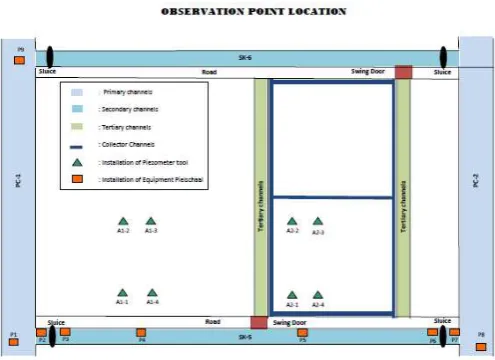
The study was conducted at reclaimed tidal lowland area of delta Berbak Tanjung Jabung Jambi Province. The representative area is consisted of one tertiary block within one secondary block for each sampling locations. The areas for field study of water management were at tertiary PC1-2 in secondary block SK 5-6 of Rantau Makmur Village. The field study period was starting at June 2012 and evaluated of the water table monitoring up to February 2015. We also conducted the daily water table monitoring in rice field and in the canal. The observation point can be seen in Figure 2.
The activity stages are consisted of preliminary survey to determine demo plot location, satellite image analysis to develop the digital network map, soil survey, hydrology installation monitoring, tertiary canal improvement, tertiary gate repairing, water table monitoring, data analysis, and reporting.
Figure 2. Observation point location in Plot A Rantau Makmur
4
To find the need of agricultural input found by farmer discussion group, and also do the meeting for developing farmer group in tertiary level.
Secondary Data Collecting. Secondary data should be collected in this stage which will be conducted at institutions or units that have data related to this study. Secondary data that is expected to be gained is inventarization of swamp reclamation area that has been developed at Tanjung Jabung Timur, especially at Rantau Rasau area. This data is consisted of numbers of developed scheme, area of each scheme, channel length and others. Moreover, agroeconomic activities within the study area, road network and institutional system are also required in this stage.
Primary Data Collecting. Primary data collecting will be conducted by using direct field survey at one tertiary blocks and hydrology monitoring is conducted at two tertiary blocks (conttroled and uncontrolled area) which are choosen previously rice fild and oil palm.
Hydrology Data Monitoring : Hydrology data is collected by water surface measurement within channel using Pielschaal at secondary blocks of A, and tertiary blok. Ground water table was monitored in 12 ha at controlled ( tertiary gate) and uncontrolled area.
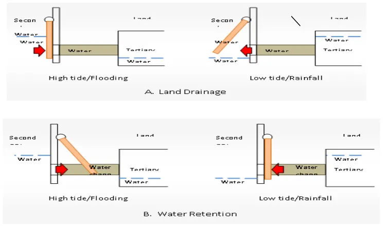
Operational System of Water Gate. Water gate operation in short is totally controlled by water energy that flow in chanels/water channels. Hydrostatics pressure of water as results of elevation differences in water surface is used to open and to close valve gate leaf. Position of gate leaf is depend on land condition that provide water for crops.
Land Draining option. Valve gate position is face to secondary channel (Figure 3). Water level in secondary channel is higher than that of tertiary channel during high tide/flooding. Therefore, water will push valve gates into the water channel walls and water channel will be closed whereas water is stop flowing. Higher water level condition on land/tertiary channel during low tide/rainfall will push valve gates in open condition so that water flow freely out of the land which results in dry condition of land.
Source: Imanudin et al., (2011).
Figure 3. Operational Sketch of Valve Gates
5
that water will push valve gate in open position and water will freely flow into tertiary channel/land. Higher water level in tertiary channel/land than that of secondary channel during low tide made water to push valve gate into close position and into water channel walls so that water can not flow into outside direction. This condition produce water retention in land.
Data Analisis. To calculate the CO2 Emission the emphiracal study was used. Accoding to Hooijer et al. (2006) had reviewed literatures and showed that for drainage depth in the range of 30 cm to 120 cm, emission will increase with magnitude of 0.91 ton CO2 per hectare per year for
each increase of 1 cm drainage depth.
RESULT AND DISCUSSIN
General Description of Area Study
Planting area for rice farm enterprise is about 0.5 to 1.0 ha. This activity is usually conducted in September. Land tillage is done by harrowing and is followed by planting of local rice variety with seeds dose of about 20 kg/ha. Fertilizing is rarely done by farmers. The general pest is wild pig. Prevention of wild pig pest is done by hunting. Harvesting is done manually by using sickle, threshed, dried by using solar energy and then stored within warehouse. Rice crop is currently not the main commodity because it had low productivity. Rice production per hectare in average was lower than 3 tons harvest dry hulled rice (GKP). This low production is due to water condition which is not freely flow into and out of the land.
The characteristic of soil is dominated by organic soil (peat). Peat layer was at 55 cm up to more than 1 meter with sapric maturity level and colour of 2,5 YR 2/0. Water table depth was in the range of 20 cm to more than 120 cm. The reduced iron layer in the form of phyrite was also identified in this area with heterogeneous depth, but it is usually located at depth of more than 65 cm from soil surface. Land use at A plot was dominated by palm oil, bushes, rice and rubber. Some palm oil and rubber plants had age of more than 5 years. The study of flooding type showed that study area is belong to B land typology in which high tide water potential can flood the land only during wet season and cannot flood the land during dry season. The probable planting pattern is rice-second crops.
On farm water management should be adjusted to peat characteristics and crop types. Construction of micro drainage channel having depth of 10 - 50 cm is needed for growth of several food crops in peat land. Paddy field rice crop in peat land only need the ditch having depth of 10-30 cm. Drainage functions are to discharge the excess water, to provide unsaturated condition for roots respiration of crops and to leach some of organic acids. The shorter the interval/distance of inter-ditch drainage, the higher is crop yield. Although drainage is important for crop growth, but deeper drainage channel will accelerate subsidence rate and peat decomposition.
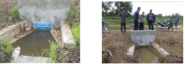
Results of field observation at study areas showed that water management network at macro level was relatively good, but the existing water gates are no longer operated by farmers. The primary channel is called as PC that consisted of PC-1 and PC-2. PC-1 is in condition of on-going rehabilitation on its walls. Secondary channel is called as SK that consisted of SK-5 and SK-6. SK-6 had already been rehabilitated, whereas SK-5 had not been rehabilitated. There was no tertiary channel at this study area. Farmers had made channels by themselves which was used as inter-land border and probably as tertiary channel. The dimension of these channels were irregular which results in impeded water flow from the land and water condition was not suitable for rice crop cultivation.
6
gates is shorter screw bar so that gates are still in hanging condition and not properly closed during the gate closing operation.
Figure 4. Condition of water level control structures at tertiary channel.
Water Table Evaluation in Tertiary Block (Rice Field)
Operation of tertiary water gate had been tested in this field trial. Water gate is operated as drainage during the wet season up to shift season and subsequently is operated as supply prior to dry season period. The change of gate function is merely conducted by moving the gate. Water gate is put in front side (downstream of secondary channel) for drainage function and it is put in rear side (toward tertiary channel) for supply function. Figure 5 showed water gate function as supply in which high tide water can flow into tertiary channel, but water can be held automatically during low tide water.
Figure 5. Operation of tertiary water gate as supply (holding water during low tide period)
Secondary channel water gate is operated when water is needed by land to fulfill crops water requirement or water is needed by community members for their household needs. Water gate is operated to hold water for community members which utilize water in channel for bathing, washing and household needs. However, water gate is not operated if community members had already have bathrooms and water can be collected simply by using pump during high tide water period. Farmers will not operate the secondary channel water gates without certain objective. Water availability in secondary channel is very important to maintain soil water balance at land plot in order not to drop quickly.
7
flooded directly by tide water, but condition of porous and crumb soil results in moist soil surface and even the flooded soil near the channel.
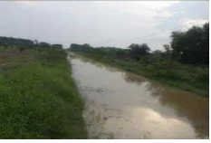
Figure 6. Secondary canal during high tide
Tertiary channel collector channel
Figure 7 . Trial for opening tertiary gate to deliver water from secondary canal (tide irrigation)
Drainage Option. Water management objective is to drain excess water due to rainfall and to prevent inflow of tide water into tertiary channel. Therefore, tertiary channel has function as maximum temporary storage (collector) of surface runoff from tertiary block and as drainage during low tide water period. This operation is very important at initial stage of wet season where farmers are conducting seed broadcast activity. Land condition should be dry (moist soil without flooding) because flooded condition will results in seed wash out by flowing water. Condition of tertiary gate location can be seen in Figure 8. This figure showed that land was not in flooded condition and ready to be dibbled (direct rice planting). Most farmers usually practice no-tillage system.
Figure 8. Tertiary gate installed at outside (tide water can not enter) with water management objective is maximum drainage.
8
Effect of Water Table For Increasing The Cropping Intensity
Previous cropping pattern is rice that grown only in the period of December to March. After improving the water system and tertiary gate operation, the depth of the water table in dry condition can be maintained at 20-30 cm below soil surface (see Figure 8). While before operating the tertiary gate the water table was found in the critical level -100 cm below soil surface. It is dangerous depth, because water capillary rise was not sufficient to become soil moisture in the top of root zone. The crop get stress water and finally no cultivated in this period. The plan for water management at tertiary level as follow as
Rice Crop (November-February period)
Water gates operation in this period is mostly in ahead position as drainage mean. Water availability in land is mostly from rainfall and water depth in land was maintained at 5-10 cm. This condition can prevent flooding occurrence and provide land condition similar to that of irrigated rice field. Recommended water gate operation can be seen in Table 1. Secondary gate was operated in open condition which facilitate free inflow and outflow of water. Rainfall is currently very rare with no observed flooding potential so far.
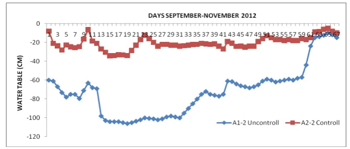
By operating the hydraulic structure in tertiary and secondary canal water table dynamics showed that study area had potential in term of sufficient water availability (Figure 9), so that planting pattern of rice-rice-corn or at least two times planting of rice-second crops can be conducted. Other benefits were consisted of relatively good quality of water and no indication of salt water intrusion despite relatively long dry season.
Table 1. Operational schedule of tertiary water gates for rice crop cultivation during First Planting Season (November-February)
9
Figure 9. Water table fluctuation in the area study
Effect of water Table Control to reduce CO2 Emission and Fire prevention
Hooijer et al. (2006) had reviewed literatures and showed that for drainage depth in the range of 30 cm to 120 cm, emission will increase with magnitude of 0.91 ton CO2 per hectare per year for each
increase of 1 cm drainage depth. If drainage of oil palm plant is assumed to be 60 cm depth in average, then yearly emission was about 54.6 ton CO2 per hectare by using this relationship.
However, emission values are highly vary based on some studies.
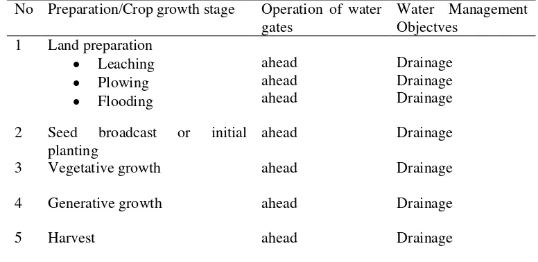
In term of the above condition, field trial at A plot is relatively successful in which water gate operation at tertiary level can significantly increase water table height. During dry period (August-September), land having no water gate showed significant decrease in depth up to 80-100 cm below soil surface, whereas land having tertiary water gate showed water table depth at 30-50 cm below soil surface (Figure 10). Water table depth can be maintained at 30 cm below soil surface by support from secondary water gate. Literatures study showed that 1 cm drawdown of water table depth will results in carbon losses with magnitude of 0.9 ton/ha/year. If water management at tertiary block is capable to increase water table height with magnitude of 50 cm, then it can replenish the carbon storage quantity of 0.9 x 50 cm or similar to 45 ton/ha/year. Therefore, water management is key factor for the sustainability of peat land conservation.
All of tidal swamp reclamation areas having peat depth more than 50 cm should be equipped with water gates in the future. One unit of water gate requires budget with magnitude of 15 million rupiahs. One tertiary block has size of 500 x 240 m or about 12 ha. Therefore, two units of water gate (budget of 30 million rupiahs) are required to control water table depth for land area of 10 to 12 ha. Water table surface during wet season is near soil surface so that carbon emission can be neglected. Emission is occurred prior to dry season. It is assumed that emission process is occurred for six months. If water table height can be increase with magnitude of 20 cm, then it will create carbon absorption equal to 20 x 0.9 = 18 ton/ha/year. If emission is occurred only for 6 months period, then carbon absorption for this period was 9 ton/ha/year.
10
Figure 10. Water table fluctuation in farm plot A between control and uncontrol treatments from May to September 2012.
Secondary gate operation should be functioned as supply starting from July to September (dry period). Trial results (Table 2) showed that water holding in secondary channel at 100 cm depth (maximum depth that can be maintained due to leakage) had increased water surface in tertiary channel at 40 cm depth. This condition can changed the previous soil water status at – 60 cm depth (higher than critical number) into – 30 cm below soil surface. As a consequence, critical number was exceeded so that peat land is free from firing risk and soil water content at root zone of plant was at field capacity condition which facilitate crop cultivation. In addition, soil subsidence and pyrite oxidation can be prevented in this condition.
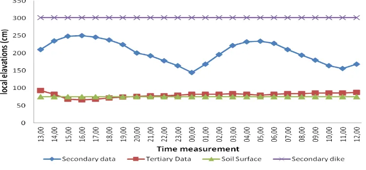
Table 2 showed the significant effect of tertiary water gate availability on land, i.e. water holding in secondary channel can increased water surface at tertiary channel and soil water. However, the increase of water table depth was not exceed the critical point for land without tertiary water gate. Soil water was still located at -45 cm depth. This condition requires tertiary water gate in addition to recorded. The first observation was started at 13:00 pm. From the observation shows that the water level in the secondary canal is maximum at high tide not to overflow the levee. Conditions of water level fluctuations in tertiary canals showed that when water entered or maximum tide, the water level is higher than ground level (soil surface). This means that the land can be irrigated with tide irrigation system.
11
through irrigation tide can raise the water level in the tertiary channel until 80 cm level, and this affects the ground water level rises to near soil surface (-2 cm) below the soil surface..
Figure 11. 24-hour observation of water level in the secondary, tertiary channel and groundwater table.
Figure 12. Water table fluctuation as a result of water retention in the groove at a height of 70-80 cm tertiary in 2014
CONCLUSION
Some approaches that can be used for peat land conservation are : (i) Overcoming the peat forest and peat land firing, (ii) replanting by using high carbon absorber crops (trees vegetation), (iii) controlling of water table level, (iv) utilizing the abandoned underbrush land, (v) Enforcement of regulations and supervision related to the use and management of peat land, and (vi) incentive provision in peat conservation.
Analysis of supply potential showed that high tide water from channel entered into the land only during wet season and was not enter into the land during the dry season. This condition showed that the land can be classified into B land hydro topography class. The potential planting pattern is rice-corn.
12
already reentered into the land at the same time. Therefore, water gates construction at tertiary channel was important.
Developing of water gate (Flap gate fiberglass) in combination with culvert is working properly in controlling water levels. Gate operation is very simple and is able to automatically open and close when the supply and retain water. The area has potentially get water supply from tide irrigation, and finally the cropping intensity can increase double.
By tertiary gate operation during cultivation period, water table possible to maintain at 15- 25 cm below soil surface. It means that maintaining water table was cause good effect to reduce CO2
emission. In the pilot study, increasing 30 cm water table depth will reducing the CO2 emission
about 27 ton/ha/year.
Operating secondary gate require mutual agreement of residents living in a block secondary, because there are lot of interests. Therefore, in the future The farmer organizations (water user associations) is needed to develop for constructing operating agreements together.
References
Blodau, C. and T.R. Moore 2003. Experimental response of peatland carbon dynamics to a water table fluctuation. Aquatic Sciences 65: 47-62. Bubier, J.L., G.
Jauhiainen, J., Limin, S., Silvennoinen, H., and Vasander, H.: Carbon dioxide and methane fluxes in drainage affected tropical peatbefore and after hydrological restoration, Ecology, 89, 3503– 3514, 2008.
Hooijer, A. 2005, Hydrology of tropical wetland forests: recent research results from Sarawakpeatswamps. In: M. Bonell and L.A. Bruijnzeel (eds), in FORESTS-WATER-PEOPLE IN THEHUMID TROPICS, 2003, Cambridge University Press,
Hooijer, A., Silvius, M., Wosten, H., and Page, S.: PEAT-CO2, ¨Assessment of CO2 emissions from drained peatlands in SE Asia, Delft Hydraulics report Q3943/2006, 36p, http://peat-co2. deltares.nl, 2006.
Imanudin, M.S, Susanto, Bakri. 2011. Peningkatan Jaringan Tata Air Untuk Mendukung Percepatan Waktu Tanam Dilahan Rawa Pasang Surut Delta Telang II Kabupaten Banyuasin Sumatera Selatan. Makalah pada Seminar Nasional PERTETA, Bandung 6-8 Desember 2011.
Kværner, J., Snilsberg, P., 2008. The Romeriksporten railway tunnel—Drainage effects on peatlands in the lake Northern Puttjern area. Eng. Geol. 101, 75-88.
Naveh, N. and Shamir, U 2004. Managing Groundwater Levels in an Agricultural Area with Peat Soils. J. Water Resources Pann. Manage/ 130 (3), 243-254. Technical paper.
Renger JJ, Hartman KN, Tsuchimoto Y, Yokoi M, Nakanishi S, Hensch TK (2002) Experience-dependent plasticity without long-term depression by type 2 metabotropic glutamate receptors in developing visualcortex. Proc Natl Acad Sci USA 99:1041–1046.