Copyright © 2007-2009 SANY Consortium Page 1 of 233
Date: 2009-10-02
Reference number of this document: OGC 09-132r1
Version:3 (Rev 3.1)
Category: OGC® Discussion Paper
Editor: Thomas Usländer (Ed.)
Specification of the Sensor Service Architecture
(SensorSA)
Copyright notice
See Copyright statement on next page
To obtain additional rights of use, visit http://www.opengeospatial.org/legal/.
Warning
This document is not an OGC Standard. It is distributed for review and comment. It is subject to change without notice and may not be referred to as an OGC Standard.
Recipients of this document are invited to submit, with their comments, notification of any relevant patent rights of which they are aware and to provide supporting documentation.
Copyright © 2009, SANY Consortium
The SANY Consortium (http://www.sany-ip.eu/partners) grants third parties the right to use and distribute all or parts of this document, provided that the SANY project and the document are properly referenced.
THIS DOCUMENT IS PROVIDED BY THE COPYRIGHT HOLDERS AND
CONTRIBUTORS „AS IS‟ AND ANY EXPRESS OR IMPLIED WARRANTIES,
INCLUDING, BUT NOT LIMITED TO, THE IMPLIED WARRANTIES OF MERCHANTABILITY AND FITNESS FOR A PARTICULAR PURPOSE ARE
DISCLAIMED. IN NO EVENT SHALL THE COPYRIGHT OWNER OR CONTRIBUTORS BE LIABLE FOR ANY DIRECT, INDIRECT, INCIDENTAL, SPECIAL, EXEMPLARY, OR CONSEQUENTIAL DAMAGES (INCLUDING, BUT NOT LIMITED TO, PROCUREMENT OF SUBSTITUTE GOODS OR SERVICES; LOSS OF USE, DATA, OR PROFITS; OR BUSINESS INTERRUPTION) HOWEVER CAUSED AND ON ANY THEORY OF
LIABILITY, WHETHER IN CONTRACT, STRICT LIABILITY, OR TORT (INCLUDING NEGLIGENCE OR OTHERWISE) ARISING IN ANY WAY OUT OF THE USE OF THIS DOCUMENT, EVEN IF ADVISED OF THE POSSIBILITY OF SUCH DAMAGE.
Preamble to the "Specification of the Sensor Service Architecture
(SensorSA)"
This document specifies the Sensor Service Architecture (SensorSA) of the European Integrated Project FP6-033564 Sensors Anywhere (SANY).
The SensorSA follows the design principles of service-oriented architectures (SOA) with a particular focus on the access, the discovery, the management and the processing of information provided by sensors and sensor networks. As such, it contains sensor-specific services and information models, however, in order to provide a higher-level, functionally and semantically richer interface to environmental information and decision-support systems it also abstracts from the peculiarities of sensors and encompasses generic information processing functionality. The SensorSA foresees mechanisms to generate events and distribute them as notifications to interested consumers. This enables spontaneous distribution of information about changing configurations in underlying sensor networks. Furthermore, the SensorSA relates the basic concepts of a resource-oriented architectural style such as resources and their representations to the SOA concepts in order to gain flexibility in discovery tasks and the mapping to underlying mainstream Web service environments.
The foundation for the conceptual architectural work for SANY is the OGC Best Practices Document 07-097 which corresponds to the Reference Model for the ORCHESTRA Architecture (RM-OA) as well as the architecture, the service and the information model specifications of the OGC Sensor Web Enablement (SWE) initiative.
Copyright © 2007-2009 SANY Consortium Page 1 of 233
Priority IST 2.5.12
Information Society Technologies
Integrated Project
Contract No.: 033564
Project Deliverable D2.3.4
Specification of the Sensor Service Architecture V3
Document Version 3.1 (29/09/2009) OGC 09-132r1
Document Control Page
Title Specification of the Sensor Service Architecture
Version 3 (Document Version 3.1)
Creator Fraunhofer IITB
Editor Thomas Usländer
Description Specification of a generic service-oriented architecture
integrating the access to, the management and the processing of sensor-related information based upon the emerging standards of the Open geospatial Consortium (OGC), and resulting from the requirements analysis of diverse application domains such as maritime risk
management, observation of geo-hazards and monitoring of air quality.
Last modified by Fraunhofer IITB (Ed.) based upon input from SP2 team
Rights Copyright “SANY Consortium”.
During the drafting process, access is generally limited to the SANY Partners.
Audience internal
public restricted,
Review status Draft
WP Manager accepted SP Manager accepted MB quality controlled Co-ordinator accepted
Where applicable: Accepted by the GA Accepted by the GA as public document
Action requested to be revised by Partners involved in the preparation of
the Project Deliverable
to be revised by all SANY Partners for approval of the WP Manager for approval of the SP Manager for approval of the Quality Manager for approval of the Project Co-ordinator for approval of the General Assembly
Revision history
Revision Date Modified by Comments
0.1 11/05/2007 TUS Initial draft structure 0.2 03/07/2007 TUS Inclusion of partners’ input 0.3 20/07/2007 TUS Result of SP2 meeting
18.-20.07.07 Sasbachwalden 0.5 13/09/2007 TUS comments of partners included 0.6 15/10/2007 TUS Results of SP2 meeting
11-12.10.07 Karlsruhe
0.7 17/10/2007 TUS comments of partners included 0.8 05/11/2007 RDE MB level QA review
1.0 09/11/2007 TUS resolution of QA comments 1.1 20/03/2008 TUS Working draft for D2.3.2
1.2 30/06/2008 TUS partner contributions integrated, consolidated and harmonised
1.41 06/08/2008 FHa Co-ordinator accepted 2.0 24/09/2008 TUS and SP2
team
Preparation of v2 (D2.3.3) 2.1 23/01/2009 TUS and SP2
team
Input to SP2 meeting Jan. 2009 and result of discussion 2.1 02/04/2009 TUS Inclusion of comments and
contributions for the final draft 3.0 08/06/2009 TUS Extended structure for D2.3.4 3.0 08/07/2009 TUS Contributions of SP2 partners EIG,
OGCE, SPB and Fraunhofer IITB 3.0 10/07/2009 TUS and SP2
team
Contribution of AIT and result of SP2 meeting, 9-10 July 209
Table of Contents
1. Executive Summary ... 12
2. Introduction ... 13
2.1. Purpose of this document ... 13
2.2. Intended Audience ... 14
2.3. Abbreviations and acronyms ... 15
2.4. Glossary ... 16
2.4.1 General Remark ... 16
2.4.2 Terms and Definitions ... 16
3. Architectural Framework ... 26
4. Enterprise Viewpoint ... 28
4.1. Architectural Requirements ... 28
4.1.1 Rigorous Definition and Use of Concepts and Standards ... 28
4.1.2 Loosely Coupled Components ... 28
4.1.3 Technology Independence ... 28
4.1.4 Evolutionary Development - Design for Change ... 29
4.1.5 Component Architecture Independence ... 29
4.1.6 Generic Infrastructure ... 29
4.2. Relationship to the ORCHESTRA Architecture ... 29
4.3. Requirements of GMES ... 30
4.4. Requirements of GEOSS ... 36
4.5. Requirements of Sensor Networks ... 39
4.6. User Requirements ... 42
4.6.1 Overview ... 42
4.6.2 Sensor Network ... 43
4.6.3 Data and Information ... 43
4.6.4 Data Quality ... 44
4.6.5 Security ... 44
4.6.6 Processing and Fusion ... 45
4.6.7 Events, Alerts and Alarms ... 46
4.6.8 Decision Support ... 47
4.6.9 User Management ... 47
5. Sensor Model ... 48
5.1. Overview ... 48
5.2. Technology Viewpoint of a Sensor ... 48
5.2.1 Simple Form of a Sensor ... 49
5.2.2 Complex form of a Sensor ... 50
5.2.3 Sensor System ... 51
5.3. Enterprise Viewpoint of a Sensor ... 52
5.4. Engineering Viewpoint of a Sensor ... 52
5.6. Information Viewpoint of a Sensor ... 56
6. Major Concepts of the Sensor Service Architecture ... 57
6.1. Overview ... 57
6.5. Resources and their Identification ... 74
6.5.1 Resources ... 74
6.5.2 URN Namespace for SANY Resources ... 75
6.5.3 Naming principles ... 76
6.7.2 Data and Service Integration ... 88
6.7.3 Interpretation ... 88
6.7.4 Discovery ... 89
6.7.5 Monitoring ... 89
6.7.6 Authentication and Authorisation ... 89
6.7.7 Quality control and management ... 90
6.8. Security ... 92
6.8.1 Introduction ... 92
6.8.2 Access Control ... 93
6.8.3 Access Control Tasks ... 95
6.8.4 Access Control Service Architecture ... 98
6.9. Conceptual Building blocks for “Plug-and-Measure” ... 99
7. Information Viewpoint ... 101
7.1. Overview ... 101
7.2. Information Model for Observations & Measurements (O&M) ... 101
7.3. Information Model of the Sensor Observation Service ... 102
7.4. Access Control Information Model... 106
7.4.1 Model for Subject Related Information ... 106
7.4.3 Groups ... 107
7.4.4 Roles ... 108
7.4.5 Policies ... 109
7.4.6 Assertion and Policy Encoding ... 109
7.5. Event Information Model ... 113
7.6. Resource Model ... 117
7.6.1 Introduction ... 117
7.6.2 ROA Concepts ... 117
7.6.3 Relationship between Resources, Services and Features ... 122
7.7. Meta-information Schema for Discovery ... 123
7.7.1 Overview ... 123
7.7.2 Generic Meta-information Sections ... 126
7.7.3 Meta-information Sections Related to Observation Discovery ... 130
8. Service Viewpoint ... 136
8.1. Overview ... 136
8.2. Services of the OGC Sensor Web Enablement ... 136
8.2.1 Overview ... 136
8.3.3 Identity Management and Authentication Service ... 145
8.3.4 Policy Management and Authorisation Service ... 147
8.3.5 Policy Enforcement Service ... 149
8.4. Services of the Mediation, Processing and Application Domain ... 150
8.4.1 Catalogue Service ... 151
8.4.2 Processing Service ... 155
8.4.3 Map and Diagram Service ... 156
8.5. Event Based Interaction Services... 159
8.5.1 Interfaces of WS-Base Notification Specification ... 160
8.5.2 Interfaces of WS-Brokered Notification Specification ... 162
9. Technology Viewpoint ... 164
9.1. Properties of a Service Platform ... 164
9.2. The SensorSA Service Platform ... 165
9.2.1 Specification of the SensorSA W3C Web Services Platform ... 167
9.2.2 Specification of the SensorSA OGC Web Services Platform ... 168
9.2.3 Specification of the SensorSA RESTful Web Services Platform ... 170
9.3. Specification of Further Platform Properties ... 171
9.3.2 Agreement on Data Formats and Application Schemas ... 172
10.2.3 Typical resource discovery policies ... 174
10.2.4 Harvesting of SOS Capabilities ... 178
10.2.5 Event-based Harvesting ... 181
10.2.6 SOS Resource Model ... 182
10.3. Policies for Sensor and Service Monitoring ... 186
10.4. Policies for Sensor Planning ... 188
10.5. Policies for Access Control ... 189
10.5.1 Patterns for Non Intrusive Access Control ... 189
10.5.2 Patterns for Access Control in Service Chains ... 191
10.5.3 Patterns for Access Control in a Multi-Protocol Environment ... 195
10.5.4 Usage of SAML ... 195
10.5.5 Usage of XACML ... 198
10.6. Processing of Quality Information ... 201
10.6.1 Attachment of quality information ... 201
10.6.2 Multi-level measurement chains ... 202
10.6.3 Visualisation of Uncertainty Information ... 203
10.6.4 Unit conversion ... 204
10.7. Handling of large data sets ... 204
10.7.1 Accessing large data blocks ... 204
10.7.2 Accessing small pieces of a large data set ... 205
10.8. Cascading Sensor Observation Services ... 206
10.8.1 Data flow optimization ... 206
10.8.2 Providing alternative views to data ... 206
10.8.3 Data (pre-)processing ... 207
10.8.4 Multi-level sensor data storage ... 207
10.8.5 Caching of data ... 208
10.8.6 Event-based interaction in cascaded scenarios ... 209
10.9. Processing and Fusion Support ... 210
10.9.1 Processing Chains ... 210
10.9.2 Uncertainty Handling in Processing Chains ... 214
10.9.3 Combining Earth Observation and In-situ data... 215
10.10. Integration of Mobile Sensors ... 217
10.11. Event Handling ... 218
10.11.1 Definition and Subscription of Events ... 219
10.11.2 Generation and Dispatching of Alerts ... 220
10.12. Plug-and-measure Support ... 221
10.12.2 Sensor recognition and connection establishment ... 223
10.12.3 Sensor Adapters ... 223
10.12.4 Sensor Access through Service Interfaces ... 224
10.12.5 Publish plug-and-measure related information ... 224
11. References ... 225
11.1. Normative references ... 225
11.2. Documents and Books ... 226
Index of Figures
Figure 2-1: Scope of the Architectural Work in SANY ... 13Figure 4-1: Major GMES Components ... 31
Figure 4-2: Basic Conceptual Representation of GMES ... 34
Figure 4-3: Ground Segment Program Board Vision GMES ... 35
Figure 4-4: GEOSS Architecture – Engineering Viewpoint (GEOSS AIP CFP, 2008) ... 38
Figure 4-5: GEOSS Interoperability Process (from GEOSS CAIR, 2007) ... 39
Figure 5-1: Sensor and actuator model (derived from (Ricker/Havens, 2005)) ... 48
Figure 5-2: Model of a simple form of a Sensor ... 49
Figure 5-3: Model of a complex form of a Sensor ... 51
Figure 5-4: Model of a Sensor System ... 52
Figure 5-5: Sensors connected to a Communication Network (here: Internet node) ... 53
Figure 5-6: Service Viewpoint of a Sensor (internal perspective) ... 54
Figure 5-7: Sensor Networks and Sensor Service Networks ... 55
Figure 6-1: Functional Domains of the SensorSA ... 58
Figure 6-2: Communication paths between the user and the sensor ... 59
Figure 6-3: Taxonomy of Interaction Models (Muehl/Fiege/Pietzuch, 2006) ... 60
Figure 6-4: Event generation verbosity levels of type binary (upper row) and nominal (lower row) ... 67
Figure 6-5: Event Processing Role Model ... 70
Figure 6-6: Event Processing Interaction Models ... 71
Figure 6-7: Event Processing Chain ... 72
Figure 6-8: Event Processing Interfaces ... 73
Figure 6-9: Naming requirements for resources ... 77
Figure 6-10: Management Space in the Sensor Service Architecture ... 79
Figure 6-11: Publish-Find-Bind Pattern ... 83
Figure 6-12: Abstract Access Control Pattern ... 95
Figure 6-13: Abstract Access Control- Pattern and Access Control Tasks ... 96
Figure 7-1: Information Model Observation &Measurement from OGC 07-022 ... 102
Figure 7-2: Information Model of the Sensor Observation Service ... 105
Figure 7-3: Profiles and Identities ... 107
Figure 7-4: Groups are special Identities ... 108
Figure 7-5: AttributeValue extension point of XACML ... 112
Figure 7-6: AttributeDesignatorType extension point of XACML ... 112
Figure 7-7: AttributeSelectorType extension point of XACML ... 112
Figure 7-9: Event model dependencies on packages from the ISO 19100 Harmonized model .. 114
Figure 7-10: Event model package structure ... 114
Figure 7-11: Event type and specializations ... 115
Figure 7-12: Resource Model ... 118
Figure 7-13: Model of the Uniform Interface ... 121
Figure 7-14: Services, features and resources and possible relationships ... 122
Figure 7-15: Meta-information resource types ... 124
Figure 7-16: Dependencies between Resource Types ... 126
Figure 7-17: Defined Meta-information Sections ... 127
Figure 7-18: Table of Contents Section ... 127
Figure 7-19: Core Meta-information Elements ... 128
Figure 7-20: Common Meta-information Elements ... 129
Figure 7-21: Feature of Interest Section ... 130
Figure 7-22: Procedure Section ... 131
Figure 7-23: Observed Property Section ... 131
Figure 7-24: SensorML Section ... 132
Figure 7-25: Example Section describing Specific Capabilities of a Service ... 132
Figure 7-26: Example Section including original OGC SOS Capabilities ... 133
Figure 7-27: Sensor Network Section ... 133
Figure 7-28: Service Description Section ... 134
Figure 7-29: Data Description Section ... 135
Figure 8-1: Overview about the Sensor Alert Service (Simonis, 2006) ... 141
Figure 9-1: Structure of the SensorSA Service Platform ... 165
Figure 10-1: Discovery of Observations ... 176
Figure 10-2: Discovery of Procedures ... 178
Figure 10-3: Creation and publication of INSPIRE and SANY related meta-information ... 180
Figure 10-4: Event-based Harvesting - Registration Phase ... 181
Figure 10-5: Event-based Harvesting - Operational Phase ... 182
Figure 10-6: Resource types for the access to sensor observations ... 184
Figure 10-7: Resource type network for the access to sensor observations ... 185
Figure 10-8: Example Representations of the SOS Resource Type “Observation Collection” .. 186
Figure 10-9: Monitoring SOS ... 187
Figure 10-10: Non Intrusive “compatible” Approach ... 190
Figure 10-11: Security Information in the SOAP Header ... 191
Figure 10-12: All elements accept identities (ID) from one IdP ... 192
Figure 10-13: All elements accept identities from different IdPs ... 193
Figure 10-14: All elements accept identities from one IdP (SC ID = service chain ID) ... 193
Figure 10-15: Access Control for HTTP based WMS & SOS ... 195
Figure 10-16: Example of a Subject NameID ... 196
Figure 10-17: Example of a Subject Confirmation ... 196
Figure 10-18: Example of an Authentication Statement ... 197
Figure 10-19: Example of an AttributeStatement ... 197
Figure 10-20: SAML in relation to the Access Control Pattern ... 198
Figure 10-21: Example of an SOS Policy ... 199
Figure 10-22: Example of an Authorisation Request for an SOS ... 200
Figure 10-23: UncertML blockin a getObservations result ... 202
Figure 10-24: Example for a multi-level measurement chain in an SOS ... 203
Figure 10-25: Multi-level sensor data storage ... 208
Figure 10-27: Processing Chain as an Instance of a Processing Service ... 212
Figure 10-28: Reception of Notifications by Processing Chain Instance ... 214
Figure 10-29: Combining Earth Observation and In-situ Data ... 215
Figure 10-30: Event handling using OGC Sensor Alert Services ... 219
Figure 10-31: Clients subscribe to sensor-defined event types ... 219
Figure 10-32: Clients define events based on observation offerings by sensors or SAS respectively ... 220
Figure 10-33: SAS defines event types based on various incoming data sets. Clients subscribe to those events ... 220
Figure 10-34: Event detection and alert dispatching at sensor ... 220
Figure 10-35: Event detection and alert dispatching by SAS ... 221
Figure 10-36: Event detection at the sensor level with conversion of alerts at SAS ... 221
Figure 10-37: Plug-and-measure Component Interaction ... 222
Figure 10-38: Smart Sensor Adapter ... 224
Index of Tables
Table 3-1: Mapping of the RM-ODP Viewpoints to the SensorSA ... 27Table 4-1: Overview about Sensor Network Topologies ... 41
Table 6-1: Roles implemented by a related event ... 68
Table 6-2: Member Event - defined values of the role property in an EventEventRelationship .. 68
Table 6-3: Procedure Identifiers in different Sensor Network Topologies ... 78
Table 6-4: Management Aspects covered in the SensorSA ... 80
Table 6-5: Catalogue Types in a SensorSA ... 84
Table 8-1: Sensor Web Enablement Services ... 136
Table 8-2 : Description of the Sensor Observation Service ... 138
Table 8-3: Description of the Sensor Planning Service ... 140
Table 8-4: Description of the Sensor Alert Service ... 141
Table 8-5: Description of the Web Notification Service ... 143
Table 8-6: Access Control Services ... 144
Table 8-7: Description of the Profile Management Service ... 145
Table 8-8: Description of the Identity Management and Authentication Service... 147
Table 8-9: Description of the Policy Management and Authorisation Service ... 148
Table 8-10: Description of the Policy Enforcement Service ... 149
Table 8-11: Architecture Service applicable for a Sensor Service Network ... 151
Table 8-12: Description of the Catalogue Service ... 155
Table 8-13: Description of the Processing Service ... 156
Table 8-14: Description of the Map and Diagram Service ... 159
Table 8-15: Comparison between OASIS WS-Notification and the OGC Sensor Alert Service160 Table 8-16: Description of WS-BaseNotification Service ... 162
Table 8-17: Description of WS-BrokeredNotification Service ... 163
Table 9-1: Options for the SensorSA Service Platform ... 166
Table 9-2: Options for the SensorSA W3C Web Service Platform ... 167
Table 9-3: Options for the SensorSA OGC Web Service Platform ... 169
Table 9-4: Options for the SensorSA RESTful Web Service Platform ... 170
1.
Executive Summary
This document specifies the Sensor Service Architecture (SensorSA) of the European Integrated Project FP6-033564 Sensors Anywhere (SANY). In its present Version 3 it corresponds to the SANY deliverable D2.3.4.
The SensorSA belongs to the family of service-oriented architectures (SOA) but has a particular focus on the access, the management and the processing of information provided by sensors and sensor networks. As such, it contains sensor-specific services, however, in order to provide a higher-level, functionally and semantically richer interface to environmental risk management applications it also has to abstract from the peculiarities of sensors and to encompass generic information processing functionality. Thus, there is a sliding passage to the functionality of a generic service infrastructure. The SensorSA foresees mechanisms to generate events and distribute them as notifications to interested consumers. This enables spontaneous distribution of information about changing configurations in underlying sensor networks, e.g. the dynamic addition or removal of sensor devices, which is a pre-requisite for
the support of the “plug-and-measure” type of operation. Furthermore, the SensorSA relates the basic concepts of a resource-oriented architecture (ROA) such as resources and their representations to the SOA concepts in order to gain flexibility in discovery tasks and the mapping to underlying mainstream Web service environments.
The foundation for the conceptual architectural work for SANY has been taken from the OGC Best Practices Document 07-097 which corresponds to the Reference Model for the ORCHESTRA Architecture (RM-OA) as specified by the European Integrated Project FP6-511678 ORCHESTRA (Open Architecture and Spatial Data Infrastructure for Risk Management). The RM-OA provides a platform-neutral abstract specification of a geospatial service-oriented architecture that responds to the requirements of environmental risk management applications. It comprises generic architecture services and information models based on and extending existing specifications of the Open Geospatial Consortium (OGC).
The objective of the SensorSA is to motivate and specify the basic design decisions derived from user requirements and generic architectural principles. It is structured according to the viewpoints of the Reference Model for Open Distributed Processing (RM-ODP) as defined in ISO/IEC 10746-1:1998 (E). The RM-ODP viewpoints are interpreted in the context of an SOA in analogy to the interpretation of the RM-ODP in the RM-OA. The SensorSA provides the basic concepts, their interrelationships (conceptual models) and abstract specifications of implementation models, services and interfaces. By abstract it is meant that the specification is independent of the specifics of a particular service platform.
2.
Introduction
2.1. Purpose of this document
This document specifies the Sensor Service Architecture (SensorSA) of the SANY project. The SensorSA belongs to the family of service-oriented architectures (SOA) with additional support of event processing but has a particular focus on the access, management and processing of information provided by sensors and sensor networks. As such, it contains sensor-specific services. However, in order to provide a higher-level, functionally and semantically richer interface to environmental risk management applications it also has to abstract from the peculiarities of sensors and to encompass generic information processing functionality. Thus, there is a sliding passage to the functionality of a generic service infrastructure.
The service-oriented architecture specified by the European Integrated Project FP6-511678 ORCHESTRA1 (Open Architecture and Spatial Data Infrastructure for Risk Management) in its Reference Model for the ORCHESTRA Architecture (RM-OA, 2007) has been chosen as the foundation for the conceptual architectural work in the SANY project. A major cornerstone for a SANY application environment as part of an implementation architecture is the Service Support Environment (ESA SSE, 2007). SSE is currently mainly used in the domain of earth observation sensors.
The architectural work in the SANY project distinguishes between
- a platform-neutral specification (SensorSA), and
- an implementation specification for the SANY application projects (SANY Implementation Architecture).
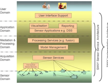
This approach is illustrated in Figure 2-1. The present document only specifies the conceptual SensorSA, which for simplicity is sometimes just called the SensorSA (SensorSA) or the SANY Architecture.
Figure 2-1: Scope of the Architectural Work in SANY
The objective of the SensorSA is to motivate and specify the basic design decisions derived from user requirements and generic architectural principles. It provides the basic concepts and their interrelationships (conceptual models) and abstract specifications. By abstract it is meant that the specification is independent of the specifics of a particular service platform. Such an abstract specification comprises service specifications, information models and interaction patterns between the major architectural components.
The specification of the SensorSA is structured according to the viewpoints of the Reference Model for Open Distributed Processing (RM-ODP) as defined in ISO/IEC 10746-1:1998 (E). The RM-ODP viewpoints are interpreted in the context of a service-oriented architecture (SOA) in analogy to the interpretation of the RM-ODP in the Reference Model for the ORCHESTRA Architecture (RM-OA, 2007).
After the illustration of the architectural design process in section 3, the specification of the business context and related requirements are described in section 4, “Enterprise
Viewpoint”. Section 5 provides the specification of the “Sensor Model” used in the
SensorSA. Further major concepts of the SensorSA are presented in section 6, followed by the core conceptual specification of the SensorSA, the specification of the Service and Information Viewpoints. Technological choices such as requirements and constraints about underlying Web service platforms are covered in the Technology Viewpoint in section 9. Engineering guidelines and recommendation how to use and compose the service and information models are covered in the Engineering Viewpoint in section 10.
Note 1: If concepts and models of the RM-OA are re-used without change, they are just referenced, sometimes accompanied by a short summary in order to enable a self-contained specification of the SANY Architecture. In cases where RM-OA concepts and models have been refined and even replaced for SANY purposes, they are specified in the present document, but using the style and the templates of the RM-OA. This approach ensures consistent editorial maintenance and review of both documents.
Note 2: The present version of the SensorSA continues and refines the work of the so-called ORCHESTRA Architecture Services (OA Services) with a focus on replacing the original Sensor Access Service as defined in the (RM-OA, 2007). In a subsequent version, this architecture specification intends to provide more application-oriented services, which are referred to in the RM-OA as ORCHESTRA Thematic Services. Then, the SensorSA will also define elements of an Application Architecture.
2.2. Intended Audience
2.3.
Abbreviations and acronyms
ADC Architecture and Data Committee (GEOSS) AS-MI Application Schema for Meta-information CAFÉ Clean Air for Europe
DG-INFSO Directorate General for Information Society (EC)
EC European Commission
ECMWF European Center for Medium range Weather Forecasting
EO Earth Observation
ESA European Space Agency
ESDI European Spatial Data Infrastructure
EU European Union
FOI Feature of Interest
FP6/7 6th/7th Framework Programme (EC)
GEOSS Global Earth Observation System of Systems GFM General Feature Model
GMES Global Monitoring for Environment and Security HMA Heterogeneous Missions Accessibility
ID Identifier
IETF Internet Engineering Task Force
INSPIRE Infrastructure for Spatial Information in the European Community
IdP Identity Provider
IS International Standard
ISO International Standardization Organisation IST Information Society Technology
JRC Joint Research Centre (EC) MIB Management Information Base
OASIS 1) Organization for the Advancement of Structured Information Standards
2) Open Advanced System for Disaster and Emergency Management (FP6 project)
OGC Open Geospatial Consortium
OMG Object Management Group
ORCHESTRA Open Architecture and Spatial Data Infrastructure for Risk Management (FP6 project)
O&M Observations and Measurement PDP Policy Decision Point
PEP Policy Enforcement Point PIP Policy Information Point
RDF Resource Description Framework
RM-OA Reference Model for the ORCHESTRA Architecture RM-ODP Reference Model for Open Distributed Processing SAML Security Assertion Markup Language
SANY Sensors Anywhere (FP6 project) SAS Sensor Alert Service
SDI Spatial Data Infrastructure SensorSA Sensor Service Architecture SensorML Sensor Model Language
SLD Styled Layer Descriptor
SN Sensor Network
SOA Service-oriented Architecture
SOA-RA (OASIS) Reference Architecture for Service Oriented Architecture SOA-RM (OASIS) Reference Model for Service Oriented Architecture SOS Sensor Observation Service
SPS Sensor Planning Service SSE Service Support Environment
SSL Secure Socket Layer
SSVN Sensor Service Network
SWE Sensor Web Enablement
UAA User Management, Authentication and Authorisation UDDI Universal Description, Discovery and Integration URI Uniform Resource Identifier
URN Uniform Resource Name
UTC Universal Coordinated Time
WADL Web Application Description Language W3C World Wide Web Consortium
WIN Wide information network for Risk Management integrated WNS Web Notification Service
XACML eXtensible Access Control Markup Language
2.4.
Glossary
2.4.1 General Remark
This document follows the ISO/IEC Directives, Part 2: Rules for the structure and drafting of
International Standards with respect to the usage of the word “shall”. The word “shall” (not “must”) is the verb form used to indicate a requirement to be strictly followed to conform to
this specification.
2.4.2 Terms and Definitions
Absolute Time (derived from ISO/IEC 18023:2006(E))
Provides 1) a means to specify an absolute time (UTC) for meta-information, and 2) a general-purpose mechanism for describing points in absolute (UTC) time.
Note: ISO/IEC 18023-1:2006 addresses the concepts, syntax and semantics for the representation and interchange of environmental data (SEDRIS). Its usage for the SensorSA as a definition and for the representation of time values is provisional. How the SEDRIS concepts go together with the ISO 19xxx series of standards will be determined. Thus, this definition may be subject to change in future versions.
Access control
Ability to enforce a policy that identifies permissible actions on a particular resource by a particular subject.
Process of gathering information about the usage of resources by subjects.
Ad hoc Sensor Network
Sensor network in which communication links and/or nodes are not continually available or
change dynamically. An ad hoc sensor network is often, but not necessarily, based on wireless communication between nodes with limited resources (energy supply, processing power). An ad hoc sensor network may include mobile sensors which belong to the network for a limited time or intermittently.
Alert
Synonym for notification.
Application (derived from http://www.opengeospatial.org/resources/?page=glossary)
Use of capabilities, including hardware, software and data, provided by an information system specific to the satisfaction of a set of user requirements in a given application domain.
Application Domain (OGC 07-097; RM-OA 2007)
Integrated set of problems, terms, information and tasks of a specific thematic domain that an application (e.g. an information system or a set of information systems) has to cope with.
Note: One example of an application domain is environmental risk management.
Application Schema (ISO 19109:2005)
Conceptual schema for data required by one or more applications.
Application Architecture (derived from OGC 07-097; RM-OA 2007)
Instantiation of a generic and open architecture (e.g. the ORCHESTRA Architecture) by inclusion of those thematic aspects that fulfil the purpose and objectives of a given
application. The concepts for such an application stem from a particular application domain
(e.g. a risk management application).
Architecture (of a system) (ISO/IEC 10746-2:1996)
Set of rules to define the structure of a system and the interrelationships between its parts.
Architecture Service (derived from OGC 07-097; RM-OA 2007)
Service that provides a generic, platform-neutral and application-domain independent functionality.
Assertion (SOA-RA, 2008)
An assertion is a proposition that is held to be true by a stakeholder. It is essentially a claim about the state of the world.
Note: In the context of SAML the term Assertion is used as a synonymous expression for
Ticket.
Authentication (SOA-RA, 2008)
Concerns the identity of the participants in an exchange. Authentication refers to the means by which one participant can be assured of the identity of other participants.
Concerns the legitimacy of the interaction. Authorization refers to the means by which an owner of a resource may be assured that the information and actions that are exchanged are either explicitly or implicitly approved.
Catalogue (derived from http://www.opengeospatial.org/resources/?page=glossary)
Collection of entries, each of which describes and points to a collection of resources. Catalogues include indexed listings of resource collections, their contents, their coverages, and of meta-information. A catalogue registers the existence, location, and description of resource collections held by an Information Community. Catalogues provide the capability to add, modify and delete entries. A minimum Catalogue will include the name for the resource collection and the locational handle that specifies where these data may be found. Each catalogue is unique to its Information Community.
Component (OGC 07-097; RM-OA 2007)
Hardware component (device) or Software Component.
Conceptual model (ISO 19109:2005(E); ISO 19101) Model that defines concepts of a universe of discourse.
Conceptual schema (ISO 19109:2005(E); ISO 19101) Formal description of a conceptual model.
Confidentiality (SOA-RA, 2008)
Concerns the protection of privacy of participants in their interactions. Confidentiality refers to the assurance that unauthorized entities are not able to read messages or parts of messages that are transmitted.
Credential
Information used as proof of Identity (e.g. a password).
Note: During an Authentication process, credentials are presented to an Identity Provider to obtain related identity information (Ticket).
Discovery (derived from W3C:
http://www.w3.org/TR/2004/NOTE-ws-gloss-20040211/#discovery)
Act of locating a machine-processable description of a resource that may have been previously unknown and that meets certain functional, informational or qualitative criteria. It involves matching a set of functional and other criteria with a set of resource descriptions.
End user (OGC 07-097; RM-OA 2007)
Members of agencies (e.g. civil or environmental protection agencies) or private companies that are involved in an application domain (e.g. risk management) and that use the
applications built by the system users.
Error (of a measurement)
Difference between the measured value and the (in general unknown) „true value‟ of the
measured property.
Anything that happens or is contemplated as happening at an instant or over an interval of time.
Event Object
Record of an action that occurred at an instant or over an interval of time.
Environment (Oxford Dictionary)
1: (noun) the surroundings or conditions in which a person, animal, or plant lives or operates. 2: (the environment) the natural world, especially as affected by human activity.
3: (computing) Overall structure within which a user, computer, or program operates.
Feature (OGC 07-097; RM-OA 2007; derived from ISO 19101)
Abstraction of a real world phenomenon (ISO 19101) perceived in the context of an
application.
Note: As in (RM-OA, 2007), the SANY understanding of a “real world” explicitly comprises
hypothetical worlds. Features may but need not contain geospatial properties. In this general sense, a feature corresponds to an “object” in analysis and design models.
Framework (http://www.opengeospatial.org/resources/?page=glossary)
An information architecture that comprises, in terms of software design, a reusable software template, or skeleton, from which key enabling and supporting services can be selected, configured and integrated with application code.
Generic (Service, Infrastructure…) (derived from OGC 07-097; RM-OA 2007)
Independent on the organisation structure and application domain, etc. For example, a service
is generic, if it is independent of the application domain. A service infrastructure is generic, if it is independent of the application domain and if it can adapt to different organisational structures at different sites, without programming (ideally).
Geospatial (http://www.opengeospatial.org/resources/?page=glossary)
Referring to a location relative to the Earth's surface. “Geospatial” is more precise in many
geographic information system contexts than "geographic," because geospatial information is often used in ways that do not involve a graphic representation, or map, of the information.
Identity (Dictionary, 2004)
Collective aspect of the set of characteristics by which a thing is definitively recognizable or known.
Note: In the SensorSA the term Identity refers to a concept that is used to recognise a subject. A subject may have several identities
Identity Provider
Entity that issues identity information and possibly acts as authentication authority
Implementation (http://www.opengeospatial.org/resources/?page=glossary)
Software package that conforms to a standard or specification. A specific instance of a more generally defined system.
Concerns the protection of information that is exchanged – either from unauthorized writing or inadvertent corruption. Integrity refers to the assurance that information that has been exchanged has not been altered.
Interface (ISO 19119:2005)
Named set of operations that characterize the behaviour of an entity.
The aggregation of operations in an interface, and the definition of interface, shall be for the purpose of software reusability. The specification of an interface shall include a static portion that includes definition of the operations. The specification of an interface shall include a dynamic portion that includes any restrictions on the order of invoking the operations.
Interoperability (ISO 19119:2005 or OGC; http://www.opengeospatial.org/resources/?page= glossary)
Capability to communicate, execute programs, or transfer data among various functional units in a manner that require the user to have little or no knowledge of the unique characteristics of those units (ISO 2382-1).
Loose coupling (W3C; http://www.w3.org/TR/2004/NOTE-ws-gloss-20040211/ #loosecoupling)
Coupling is the dependency between interacting systems. This dependency can be decomposed into real dependency and artificial dependency: Real dependency is the set of features or services that a system consumes from other systems. The real dependency always exists and cannot be reduced. Artificial dependency is the set of factors that a system has to comply with in order to consume the features or services provided by other systems. Typical artificial dependency factors are language dependency, platform dependency, API dependency, etc. Artificial dependency always exists, but it or its cost can be reduced. Loose coupling describes the configuration in which artificial dependency has been reduced to the minimum.
Meta-information (OGC 07-097; RM-OA 2007)
Descriptive informationabout resources in the universe of discourse. Its structure is given by a meta-information model depending on a particular purpose.
Note: A resource by itself does not necessarily need information. The need for meta-information arises from additional tasks or a particular purpose (like catalogue organisation), where many different resources (services and data objects) must be handled by common methods and therefore have to have/get common attributes and descriptions (like a location or the classification of a book in a library).
Meta-information model (OGC 07-097; RM-OA 2007) Implementation of a conceptual model for meta-information.
Non-repudiation (SOA-RA, 2008)
Notification
Message that transports one or more events. Depending on the form of the event, the notification may resemble the event that it transports.
Note: An alert is a notification. The terms notification and alert are used synonymously.
Observed Property (derived from OGC 07-022r1)
Identifier or description of the phenomenon for which the observation result provides an estimate of its value.
Observation (OGC 07-022)
Act of observing a property or phenomenon, with the goal of producing an estimate of the value of the property.
Open Architecture (OGC 07-097; RM-OA 2007)
Architecture whose specifications are published and made freely available to interested vendors and users with a view of widespread adoption of the architecture. An open architecture makes use of existing standards where appropriate and possible and otherwise contributes to the evolution of relevant new standards.
Operation (ISO 19119:2005; http://www.OpenGIS.org/docs/02-112.pdf)
Specification of a transformation or query that an object may be called to execute. An operation has a name and a list of parameters.
ORCHESTRA Architecture (OGC 07-097; RM-OA 2007)
Open architecture that comprises the combined generic and platform-neutral specification of the information and service viewpoint as part of the ORCHESTRA Reference Model.
ORCHESTRA Reference Model (http://www.eu-orchestra.org)
The ORCHESTRA Reference Model comprises a specification of all RM-ODP viewpoints for the open architecture for risk management.
Note: The ORCHESTRA Reference Model is specified in (RM-OA, 2007) and is the result of the European Integrated project ORCHESTRA. The relationship of the SANY Sensor Service Specification to the ORCHESTRA Reference Model is specified in section 6.1.
Phenomenon (OGC 07-022)
Concept that is a characteristic of one or more feature types, the value for which may be estimated by application of some procedure in an observation.
Plug-and-measure
Refers to the degree of capability to add a new sensor to a sensor network, register it in a
service network and access its observations through services in all functional domains of a
sensor service network without additional manual intervention.
Policy (derived from SOA-RM, 2006)
Representation of a constraint or condition on the use, deployment, or description of a
resource.
Describes the goal of the usage of the resources.
(Service) Platform (OGC 07-097; RM-OA 2007)
Set of infrastructural methods, technologies and rules that describe how to specify service
interfaces and related information and how to invoke services in a distributed system.
Examples for platforms are Web Services according to the W3C specifications including a GML profile for the representation of geographic information or a CORBA-based infrastructure with a UML profile according to the OMG specifications.
Principal See Identity
Profile
Information (set of attributes) describing a subject.
Reference Model (ISO Archiving Standards; http://ssdoo.gsfc.nasa.gov/ nost/isoas/us04/defn.html)
Framework for understanding significant relationships among the entities of some environment, and for the development of consistent standards or specifications supporting that environment. A reference model is based on a small number of unifying concepts and may be used as a basis for education and explaining standards to a non-specialist.
Representation (Richardson/Ruby 2007)
Comprises any useful information about the current state of a resource.
Resource (Richardson/Ruby 2007)
Anything that‟s important enough to be referenced as a thing itself.
Note: Applied to geospatial service-oriented architectures (derived from OGC 07-097; RM-OA 2007): Functions (possibly provided through services) or data objects (possibly modelled as features).
Security Domain
Set of resources protected in accordance with a common policy.
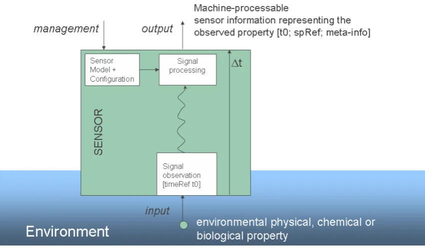
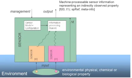
Sensor
Entity that provides information about an observed property at its output. A sensor uses a combination of physical, chemical or biological means in order to estimate the underlying
observed property. At the end of the measuring chain electronic devices produce signals to be processed.
Note: A more detailed discussion about simple and complex forms of a sensor as well as sensor systems, also in the context of environmental models, is given in section 5. Here a sensor model is presented according to several viewpoints.
Sensor Network
Collection of sensors and optional processing nodes, in which information on properties
observed by the sensors may be transferred and processed.
Sensor Service Architecture (SensorSA)
Open Architecture comprising a platform-neutral conceptual specification of the architectural components of a service network that includes the access to and the management of sensors,
sensor networks and sensor-related information. Sensor Service Network
Service network that is compliant to the SensorSA specification.
Sensor System
System whose components are sensors. A sensor system as a whole may itself be referred to as a sensor with an own management and sensor output interface. In addition, the components of a sensor system are individually addressable.
Service (ISO 19119:2005)
Distinct part of the functionality that is provided by an entity through interfaces.
Service Instance (derived from OGC 07-097; RM-OA 2007)
Executing manifestation of a software component that provides an external interface of a
service according to an implementation specification for a given platform.
Service Network (derived from OGC 07-097; RM-OA 2007)
Set of service instances that interact in order to serve the objectives of applications. The basic unit within a service network for the provision of functions are the service instances.
Session
Temporarily valid ticket
Signal
Any internal representation (i.e. internal to the sensor) of the observed property.
Software Component (derived from component definition of
http://www.opengeospatial.org/resources/?page=glossary)
Program unit that performs one or more functions and that communicates and interoperates with other components through common interfaces.
Spatial Context
Specification of a spatial location of an observed property determined by a combination of a point, a line, an area, a volume and/or a vector field.
Note: As an example for the combination of an area and a point, consider a sensor that is capable of recording an image of an area. It may deliver both a spatial context for the area (e.g. the polygon of the area) and/or for several points within that area (e.g. a grid laid upon the area).
Subject (OGC 07-097; RM-OA 2007)
Abstract representation of a user or a software component in an application.
Something of interest as a whole or as comprised of parts. Therefore a system may be referred to as an entity. A component of a system may itself be a system, in which case it may be called a subsystem.
Note: For modelling purposes, the concept of system is understood in its general, system-theoretic sense. The term "system" can refer to an information processing system but can also be applied more generally.
System User (OGC 07-097; RM-OA 2007)
Provider of services that are used for an application domain as well as IT architects, system developers, integrators and administrators that conceive, develop, deploy and run applications
for an application domain.
Temporal Context
Specification of the temporal reference of an observed property based on the absolute time. It can be a single point in time, a time sequence, a time period or a combination of these. In a sampling system for example several time periods and time points are needed to describe the time behaviour. However, a time point is already an abstraction which does not really exist. It means a very small time interval.
Thematic Service (derived from OGC 07-097; RM-OA 2007)
Service that provides an application domain-specific functionality built on top and by usage of
architecture services and/or other thematic services.
Ticket
Information issued by an identity provider to be used as proof of identity when accessing a
resource.
Uncertainty
Quantified description of the doubt about the measurement result.
Note: The error of a measurement may be small, even though the uncertainty is large.
Universe of discourse (ISO 19101)
View of the real or hypothetical world that includes everything of interest.
User (OGC 07-097; RM-OA 2007)
Human acting in the role of a system user or end user.
UTC - Coordinated Universal Time (ISO 19108:2004 (E))
Time scale maintained by the Bureau International des Poids et Mesures (International Bureau of Weights and Measures) and the International Earth Rotation Service (IERS) that forms the basis of a coordinated dissemination of standard frequencies and time signals (ITU-R Rec.TF.686-1 (1997))
Viewpoint (RM-ODP)
Web Service
Self-contained, self-describing, modular service that can be published, located, and invoked across the Web. A Web service performs functions, which can be anything from simple requests to complicated business processes. Once a Web service is deployed, other
applications (and other Web services) can discover and invoke the deployed service.
W3C Web Service (W3C,
http://www.w3.org/TR/2004/NOTE-ws-gloss-20040211/#webservice)
3.
Architectural Framework
Continuing the pattern established by the ORCHESTRA project (RM-OA, 2007), an approach based on the ISO Reference Model for Open Distributed Processing (ISO/IEC 10746-1:1998) has been selected for the design of the SensorSA. Since a sensor service network will have the characteristic of a loosely-coupled network of systems and services instead of a “distributed
processing system based on interacting objects” as presumed by RM-ODP, the RM-ODP concepts are not followed literally. The usage of RM-ODP for the design and documentation of a sensor service architecture is two-fold:
1. It is applied on a big scale to the structuring of ideas and the documentation of the SensorSA itself. A mapping of RM-ODP viewpoints to the needs of the SensorSA has been carried out and is summarised in Table 3-1:
- The second column of Table 3-1 provides the original definitions of the viewpoints as given in the OpenGIS® Reference Model using the terms of the OpenGIS® glossary.
- The third column of Table 3-1 indicates the mapping of the viewpoints to the SensorSA needs using the terms as defined in the SensorSA glossary (see section 2.3).
Note: In order to highlight the fact that, as in RM-OA (2007), the SensorSA deployment will have the nature of a loosely-coupled distributed system based on networked services rather than a distributed application based on computational
objects, the “computational viewpoint” is referred to as “service viewpoint” in the
SensorSA.
- The fourth column of Table 3-1 provides examples of what will be defined in the respective viewpoint.
2. It is applied on a small scale to the description of the sensor model in section 5. Here, the SensorSA understanding of a sensor is considered from the perspective of the five RM-ODP viewpoints. By this approach the multi-fold facets of the term sensor may be captured.
View-in terms of the system and the user requirements as
4.
Enterprise Viewpoint
4.1.
Architectural Requirements
The architectural and iterative design approach as described in (RM-OA, 2007) is taken as the basis for the specification of the SensorSA. The architectural principles that have guided the specification of the ORCHESTRA Architecture have been adapted and assessed specifically for service networks that include access to sensors and sensor-related information. The result is presented in the following sections.
4.1.1 Rigorous Definition and Use of Concepts and Standards
The SensorSA shall make rigorous use of proven concepts and standards in order to decrease dependence on vendor-specific solutions, help ensure the openness of a sensor service network and support the evolutionary development process of the SensorSA.
Note: The SensorSA relies on the standard series “OGC Sensor Web Enablement (SWE)” (Botts et al, 2006) as the starting point to refine the access and the management of sensor-related information.
4.1.2 Loosely Coupled Components
The components involved in a sensor service network shall be loosely coupled, where loose coupling implies the use of mediation to permit existing components to be interconnected without changes.
Note: In this stringency, this architectural principle is restricted to the acquisition, application and user domains of a sensor service network (see section 6.1) as its application in the sensor domain may not be possible due to the predominance of proprietary solutions. Furthermore, performance and dependability requirements may necessitate a sensor network with fixed communication relationships and tight coupling of the sensor components.
4.1.3 Technology Independence
The SensorSA shall be independent of technologies, their cycles and their changes as far as practically feasible. It must be possible to accommodate changes in technology (e.g. lifecycle of middleware technology) without changing the SensorSA itself. The SensorSA shall be independent of specific implementation technologies (e.g. middleware, programming language, operating system). In general and if possible, the SensorSA shall not be influenced by or deal with limitations of specific implementation technologies. However, the SensorSA shall be explicitly designed such that it may deal with technical limitations of specific implementation technologies in the sensor domain (see section 6.1).
4.1.4 Evolutionary Development - Design for Change
The SensorSA shall be designed to evolve, i.e. it shall be possible to develop and deploy the system in an evolutionary way. The SensorSA shall be able to cope with changes of user requirements, system requirements, organisational structures, information flows and information types in the source systems.
4.1.5 Component Architecture Independence
The SensorSA shall be designed such that a service network and source systems (i.e. existing information systems, sensors and sensor networks) are architecturally decoupled. This means that the SensorSA shall not impose any architectural patterns on source systems for the purpose of having them collaborate in a service network, and no source system shall impose architectural patterns on a SensorSA.
Note: This architectural principle relies on the RM-OA definition of a source system as
being a “container of unstructured, semi-structured or structured data and/or a provider of functions in terms of services. The source systems are of a very heterogeneous nature and contain information in a variety of types and formats”. In the context of a sensor service
network, a source system may also be a sensor or a sensor network to be integrated in a service network. Important here is that a source system is seen as a black box, i.e. no assumptions about its inner structure are made when designing a service network.
4.1.6 Generic Infrastructure
The SensorSA services shall be independent of the application domain. This means that the SensorSA services shall be designed in such a flexible and adaptable way that the SensorSA services can be used across different thematic domains and in different organisational contexts, and that the update of integrated components (e.g. sensors, applications, systems, ontologies) causes little or ideally no changes to the users of the SensorSA services.
4.2.
Relationship to the ORCHESTRA Architecture
The architectural heritage of the SensorSA is the ORCHESTRA Architecture specified in (RM-OA, 2007) as an “open architecture that comprises the combined generic and platform-neutral specification of the information and service viewpoint as part of the ORCHESTRA Reference Model” (RM-OA). Consequently, the SensorSA builds upon the components of the ORCHESTRA Architecture which comprise:
- Rules and guidance about how to specify information and service models in the context of international standards. In the RM-OA, these rules are formally specified in an ORCHESTRA Meta-model2 for information and for services.
2The ORCHESTRA Meta-model is an extension of the ISO/OGC-defined General Feature Model. It consists of
- Basic re-usable specification units for information models (e.g. pre-defined feature types3) and service models (e.g. re-usable interfaces).
- Textual and document templates that guide the specification of services.
- A series of textual descriptions and formal specifications of generic services (so-called ORCHESTRA Architecture Services or, in short, architecture services) that are application- and technology independent.
It is the objective of the SANY project to re-use and apply these components in the context of the SensorSA to the extent that they fulfil the requirements of building service networks4 based on sensor information and higher-level sensor information processing.
Thus, there are two cases:
1. The SensorSA contributes to the architectural level in the sense that it specifies new architectural concepts or new architecture services, or it refines existing architecture services.
2. The SensorSA specifies new application-oriented services (in the RM-OA categorised as ORCHESTRA Thematic Services or, in short, thematic services) that typically require the call of underlying architecture service operations. In this case the SensorSA defines a so-called ORCHESTRA Application Architecture5.
In both cases, the SensorSA uses the templates and the rules of the RM-OA in order to specify the refined and the new components.
4.3.
Requirements of GMES
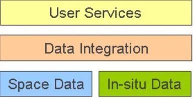
As illustrated in Figure 4-1 GMES consists of four major components:
- The space component providing earth observation satellite data.
3
In accordance with ISO and OGC, the RM-OA defines a feature as an “Abstraction of a real world
phenomenon” (ISO 19101). Note, however, that the ORCHESTRA understanding of a “real world” explicitly
comprises hypothetical worlds. Features may but need not contain geospatial properties.
4 In analogy to (RM-OA, 2007) a service network here is defined to be set of networked hardware components
and service instances that interact in order to serve the objectives of applications. Thus, the basic units within a service network for the provision of functions are the service instances, i.e. executing manifestations of software components that offer their functionality in terms of services.
5 The RM-OA defines an ORCHESTRA Application Architecture to
be an “instantiation of the ORCHESTRA Architecture by inclusion of those thematic aspects that fulfil the purpose and objectives of a given application.”
The concepts for such an application stem from a particular application domain (e.g. a risk management application).
- The in-situ component providing ground and airborne data as well as socio-economic data.
- The data integration and information management component providing access to and processing of the above space and in-situ data.
- The high level user services component allowing for monitoring of the various aspects of our environment.
Figure 4-1: Major GMES Components
The final report for the GMES initial period (GMES FR, 2004) provides the following key architectural requirements on pages 25-26:
―For GMES to become a success, the architecture needs to facilitate the integration of standalone data and information elements. It should allow to the selection and aggregation of information from heterogeneous sources and should provide the capability to translate data and information between the various sources in real time. This applies as much to the incorporation of socio-economic data and information, as well as products derived from the space and in situ observing networks.
GMES must therefore provide a structured framework for data integration and information management, i.e., a European shared information capacity. The following key architectural and user-oriented requirements will therefore drive the implementation of GMES:
- Openness, based on agreed open standards, facilitating seamless communication and interoperability, i.e. the ability of different devices or systems (usually from different vendors) to work together, as well as enabling user service autonomy;
- Federated architecture, enabling systems to grow and evolve;
- Simplicity of architecture (e.g. modularity of components), to break the complexity barrier, systems must be made easier to design, administer and use;
- Self-configuration, programmability, scalability (e.g. to handle various levels of operational load and external conditions);
- Dependability, i.e. the system's resilience to security threats or breakdown;
- Data security, protection of provider and user data against alteration, theft and misuse;
- Quality of service;
- Ubiquity of access, including global reach.‖
In a reflection paper on Data Integration and Information Management Capacity (GMES, 2005), prepared by DG-INFSO in close collaboration with ESA and JRC and IST Integrated Projects of the 6th Framework Programme, the following provisional and non-exhaustive list of functional requirements is given:
―1. Selection of information from heterogeneous sources a. Publishing
b. Discovery (data/information and services)
c. Catalogue (search, browse, etc.)
d. Tasking
e. Ordering
f. Access to data
g. Data/information Mining
2. Aggregation of information from heterogeneous sources
a. Data/information fusion
b. Map overlay
3. Translation of data and information between various sources in real time
a. Geo-referencing and re-projection
b. Feature translation
c. Semantic interoperability
d. Multilingual
e. Data formatting
f. Data generalisation
4. Others
a. User management and Security (including Terms and Conditions to access GMES Services)
b. Service level agreement
c. Quality (for metadata7, data and services)‖
7 As this text is cited from (GMES, 2005), the term “metadata” is used here whereas in the SANY Service
The same reflection paper suggests that the approach needed to create an efficient data
integration and information management component is to use a “system of systems” design as
explained below:
―The GMES information and services infrastructure goes well beyond a simple exchange of data. It addresses the need to integrate business and workflow processes which span across boundaries, be they political, administrative or thematic. It addresses the main issues of heterogeneity and fragmentation of the information: ―heterogeneity‖ meaning that the same information is often represented differently, ―fragmentation‖ meaning that needed information is spread over multiple locations.
The approach is to seamlessly integrate existing systems into a ―system of systems‖ perspective. System of systems is an emerging design and development method of complex systems build from large scale component systems. The subsystems that comprise the system of systems are generally built by different organisations, having different goals, are very often built to different quality standards, and are managed independently.
Reusing existing legacy systems in a dependable fashion without the need for extensive re-engineering is a key problem currently faced by industry. System of systems can be seen as new systems linking data, services and workflows to produce new data, new services together with metadata (information about the information products generated8).
This approach, which was a research topic in the last decade, is now becoming sufficiently mature. In the short term, robust system architectures will be developed and tested allowing the exchange of data and services that are well identified: This is the syntactic interoperability phase. In the longer term, we expect to achieve significant semantic interoperability, which will allow cross-system search for data and services. It could be dubbed the ―GMES Google‖ since it will work for data and services in the way web search engine works for web pages.
A number of non technical obstacles should however be addressed to eventually reduce the complexity of the implementation, such as trusted electronic billing principles between data providers and services providers to partly overcome the hurdles created by different data policies. Mechanism should also be agreed upon to manage access privilege across institutional borders in a practical, transparent and secure way.
This approach will allow sharing and efficient management of information that is consistent across organisations, borders and thematic domains such as from land use and mapping to risk management and security.‖
The suggested system of systems approach is still regarded today as the best approach as indicated in the following excerpt of the report of Joint Operability Workshop held in April 2007 (JOW, 2007):
―There was broad agreement that any proposed solution for a single information space for the environment must allow for multiple architectures and hence be a ―system of systems‖. Further comments on this topic included: