ADVANCED
MONITORING
SYSTEMS
FOR
LANDSLIDE
RISK
REDUCTION
IN
THE
'SIQ'
OF
PETRA
(JORDAN)
G. Delmonaco a, M. Brini b, G. Cesaro c, *
a ISPRA, Geological Survey of Italy and UNESCO Consultant,
Via Vitaliano Brancati 48 Rome, 00141 Italy - [email protected]
b EnvEve SA, Via Cantonale 18, Manno, CH-6928, SWITZERLAND - [email protected] c UNESCO Amman Office, 9 Yacoub Ammari Str., Abdoun, Amman 11181, Jordan - [email protected]
KEYWORDS: monitoring, geological conservation, rock fall, Internet of Things, Petra, UNESCO World Heritage Site
ABSTRACT:
The UNESCO World Heritage Site of Petra is characterized by a spectacular geo-archaeological landscape that lead to its inscription as World Heritage Site in 1985. Petra is also a fragile site facing a wide diversity of risks, ranging from those posed by environmental factors as well as those attributed to tourism. In recent years, hazardous natural phenomena were registered as increasingly impacting the site, and most specifically the 'Siq', a 1.2 km naturally formed gorge serving as the only tourist entrance to the archaeological park, posing a major threat to cultural heritage and visitors. These recent events have prompted UNESCO Amman Office, in cooperation with the national authorities, to develop a strategy towards prevention and mitigation of instability phenomena at the 'Siq' and, thus, further contribute to the management and conservation of the site through the implementation of the multi-year Italian funded "Siq Stability" project Actions have been primarily focusing on the analysis of the stability conditions of the 'Siq' slopes, the installation of an integrated monitoring system and the definition and implementation of mitigation measures against rock instability. This paper reports a detailed description of the integrated monitoring system installed paying particular attention on the wireless monitoring devices and the EASA applications, which proved to be some of the most successful systems implemented in the framework of the project. Some preliminary results regarding the data retrieved, policies applied and actions taken to ensure long-term sustainability and capacity development of the national authorities are also reported.
*Corresponding author
1. INTRODUCTION AND SCOPE OF WORK
1.1 The Petra Archaeological Park
The World Heritage Site of Petra lies in a large valley surrounded by mountain ranges. Its geology is dominated by Palaeozoic sandstone rocks that form most of the hand-carved Nabataean rock monuments of Petra. The 'Siq' is a 1.2 km naturally formed gorge in the sandstone rocks that represents the main entrance to the archaeological site. Because of the religious niches and water management features, the 'Siq', in its entirety, is considered a monument of religious and historic significance, considerably contributing to the Outstanding Universal Value of the site.
1.2 UNESCO Risk Prevention Strategies in Petra
Petra is also a very fragile site facing a wide diversity of risks, ranging from those posed by environmental factors, such as natural and geological hazards, as well as those attributed to tourism and the lack of adequate site management and emergency measures for tourist and monument safety. In recent years, natural phenomena, such as earthquakes, floods and landslides were registered as increasingly impacting the site, and most specifically the 'Siq' posing a major and permanent threat to cultural heritage and visitors.
Preserving Petra’s Outstanding Universal Value for which the site has been inscribed in the World Heritage List (UNESCO, 2016), is one of the corporate UNESCO priorities for culture actions in Jordan, in line with the UNESCO Strategy for Risk
Reduction at World Heritage properties (UNESCO, 2006). Since 2009, the UNESCO Office in Amman has supported the Petra Archaeological Park and the Department of Antiquities in assessing, managing and mitigating natural hazards in the 'Siq' with the final objective to develop a strategy towards prevention and mitigation of instability phenomena at the 'Siq' and, thus, further contribute to the management and conservation of the site. From 2009 to 2015, UNESCO engagements focused on addressing for the first time the impact of landslides phenomena in the 'Siq'. In 2009 a technical expertise in engineering geology was provided to the national authorities to support the consolidation of a fractured block in the 'Siq'.
Through the implementation of the projects "Rapid Risk Assessment" (2011) and "Siq Stability", Phase I (2009-2015) actions centered on the analysis of the stability conditions of the 'Siq' slopes based on a comprehensive site documentation, the installation of an integrated monitoring system and the definition of mitigation measures against rock instability (Delmonaco et al., 2015; Delmonaco et al., 2014; Delmonaco et al., 2013a; 2013b; 2013c).
levels of stakeholders on landslide and flash flood risk (Cesaro et al., 2017).
Monitoring of instability phenomena in the 'Siq' through the installation of an advanced integrated monitoring system -from remote to field- has represented one of the most innovative, successful and sustainable approaches of the project for the detection and control of deformation processes.
2. SLOPE PROCESSES AND INSTABILITY
2.1 The geological and geomorphological features of the 'Siq'
The 'Siq' of Petra is 1,2 km in length and 3 m to 15.70 m in width. It is formed by very steep slopes with variable height from the ground level, from few meters at the entrance to several tens of meters in some areas of the path. The ‘Siq’ is prevalently formed by the Disi and Umm Ishrin sandstone formations (Cambrian-Ordovician) with a typical rupestrian and massive forms (Bender, 1974). The majority of the rock monuments of Petra were almost entirely cut in the Umm Ishrin formation due to its good mechanical strength and facility to hand-carving (Amireh et al., 2001).
The geomorphology of the 'Siq' is the result of long and short-term factors such as tectonic uplift, erosion due to runoff, differential erosion and weathering of sandstone rocks. The mainly E-W orientation of the ‘Siq’ and its meandering course are a consequence of the intersection of numerous faults and master joints. Discontinuities in the 'Siq' rock slopes are represented by bedding (generally sub-horizontal), faults and master joints (mainly sub-vertical), other discontinuities (from vertical to medium slope angle) correlated with the geomorphological evolution of the ‘Siq’.
2.2 Slope instability conditions
According to local orientation, density and persistence of discontinuities, slope instability conditions can occur and can affect rock blocks with variable dimension depending on types and degree of structural control. The ‘Siq’ being one of the main channels of the Wadi Musa catchment, collects a series of lateral steep channels that convey superficial water during short and intense rainfall events.
Due to the above conditions, the ‘Siq’ of Petra presents a very diffuse hazard of rock slope failures and instability, mainly represented by the following phenomena:
a) fall of loose debris (very small blocks/stones) from the cliff edges and terraces caused by heavy rainfall and flash-floods; b) fall/toppling/sliding of small/medium and large size blocks along pre-existing discontinuities of the rock mass (Figure 1), due to progressive instability caused by climatic, geological and geomorphological factors (Delmonaco et al., 2014; 2013a; 2013b, 2013c).
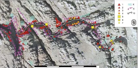
Figure 1. Landslide inventory map of the Petra area
Differently from debris fall, which is in Petra mostly caused by heavy rainfall and flash-floods, phenomena of rock detachment are characterized by a long-term evolution governed by various factors such as local lithology, geostructural setting, weathering, water circulation, climatic parameters, and human effects. Slope failures in rock masses outcropping in Petra generally occur along pre-existing discontinuities and their triggering is mostly associated with short-term factors depending mainly on climatic parameters (i.e. temperature/humidity changes) and seismicity factors (Delmonaco et al., 2014; 2013a; 2013b;2013c).
In the last decade, several landslide events, mostly rock falls and rock slides, with different magnitude (volumes from < 1 m3 to > 10 m3) have occurred in the 'Siq' (2009, 2015) and in the core area of the site (2009, 2010, 2016). A brief description of such events is summarized in Table 1.
Table 1. Inventory of recent landslide events in Petra.
In Wadi Musa, rainfall precipitation is characterized by an average yearly recurrence of 4-5 heavy rainfall events, from October to April, with high intensity and short duration that can cause removal and fall of loose debris from the upper slopes and outlets of secondary channels (Delmonaco et al, 2013c). The analysis of the rainfall data recorded in the meteorological station installed in June 2013 in the framework of the 'Siq' Stability Project, Phase I, reports a climatic scenario for the 'Siq' characterized by an increase of critical precipitation in terms of rainy days with high rainfall intensity as well as by heavy rainfall events that have occurred in late April-early May. The reasons of such anomalies can be correlated either to natural climate trends or, more probably, to climate change effects. Regardless of possible climatic change effects in Petra (Matouqa et al., 2013; Beck and Collet, 2011) and based on available meteorological records and recent rock failures inventory (although greatly incomplete), in the 'Siq' of Petra it is possible to estimate a yearly return time TR for debris fall as TR =4÷5 /yr whereas for rock slope failures (rock fall, rock slide) the return time can be assumed as TR =0.1÷ 0.2/yr (Delmonaco, 2016) as shown in Figure 2.
Figure 2. Relationship between magnitude and frequency of instability phenomena of rock slope failures (points) and debris
3. MONITORING FOR RISK PREVENTION
3.1 The integrated monitoring system
Considering the morphological setting and slope instability processes, during the Phase I of the "Siq Stability" project the following monitoring techniques have been proposed, designed, implemented and installed for the monitoring of
the 'Siq' slopes (Delmonaco et al., 2015).
Satellite SqueeSAR™ analysis with permanent scatters techniques, to evaluate potential regional deformation pattern of the site and possible 'Siq' border effects;
Automated crack-gauge network, with wireless connection, to monitor main cracks and isolated potentially unstable blocks, with a low environmental impact technology;
High resolution total station network measuring a prisms network, individual reflectorless points network and reflectorless grid network in the 'Siq' slopes, for monitoring slope/blocks deformation; Manual crack gauge network on 25 main
discontinuities.
Among all the systems implemented, the most coherent, accurate and robust results have been obtained through the automated crack-gauge network provided by EnvEve. Results achieved through the other systems led to questionable results on detection of slope deformation in the 'Siq'.
3.2 Direct Rock Block Monitoring with Wireless Network
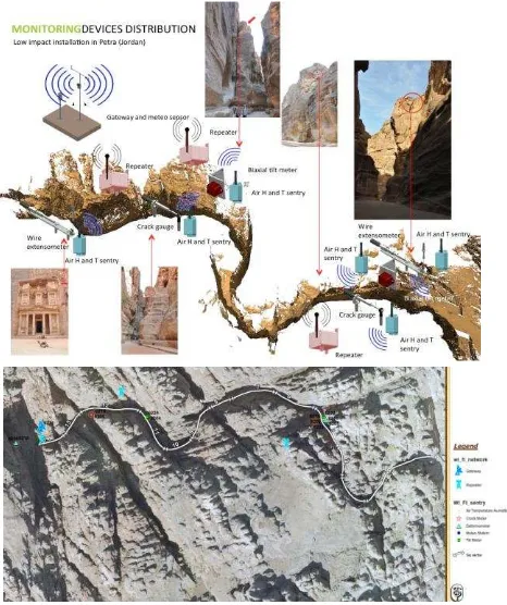
In order to measure with high precision and accuracy the rock blocks response to daily and seasonal displacement, a wireless monitoring system was installed in the 'Siq' in 2013 (Figure 3).
Figure 3. Distribution of the wireless monitoring devices
The EnvEve SA wireless monitoring system is composed of 2 wire deformometers, 2 crack deformometers and 2 tiltmeters, 6 air-temperature sensors, a meteorological station, with wireless technology sensors for on-time registration and transmission of data. Displacement of the main fractures, inclination of the blocks and meteorological parameters are the main data collected by the system. The general structure of the EnvEve wireless monitoring system is based on the following components: field devices constituted of wireless sentries measure the displacement (resolution 0.01 mm) and inclination (resolution 0.01°) values and send them via radio to a Short-Range Repeater (SSR); the SSR routes the sentries radio message to a Long-Range Repeater (LRR); the LLR adds rainfall, shielded temperature, humidity and wind direction and forwards all data to the main gateway located in the upper 'Siq'; the gateway collects and sends data to the main EnvEve server via GPRS.
Figure 4. Large unstable block located in sector 5 equipped with wire deformometer, tilt meter and air and humidity sensors.
The sensors are provided with 5-years long-life batteries and solar cells in order to assure a continuity in data recording in the event of a breakdown.The system was not originally designed to work as a near-time alarm or early warning system, but to assess rock displacement in the 'Siq' in connection with meteorological data.
3.3 The NaturAlert and EASA platforms
Besides the installation of the devices, storage, visualization and analysis of the data collected are managed through two different platforms, NaturAlert and EASA (EnvEve Advanced Software Analytics) developed during the implementation of the "Siq Stability" project.
The NaturAlert platform allows a predefined number of users (technical project team) to view, download and analyze the data through a web connection to the project main server. The data collected include crack deformation, slope angle variation, air temperature and humidity variation, rainfall and wind speed. The system is particularly useful to verify in real time the functionality of any device installed in the 'Siq' and detect any breakage.
of environmental phenomena. This advanced IoT analytics cloud solution complements the innovative approach applied as part of the UNESCO "Siq Stability" project allowing to extract information out of different data systems in a cooperative and efficient manner. Specifically, EASA allows a) hardware interoperability by receiving data from additional sources and devices; b) easier treatment of different data formats to deal with historical data import, connection to external servers for real time data exchange, data format conversion; c) advanced step by step supported data series processing to i.e. label and manage data series, clean configurable data series with real time view, data series consistency check; d) real time analytics engine to implement analytics formula without coding or software programming, e) real time data customs and view on results on dynamic data series to facilitate graphic interaction and share.
At the present stage of the project, a specific EASA APP is being developed to manually collect data directly in the field such as manual monitoring measurements and/or upload qualitative data related to the monitoring of landslide risk mitigation works conducted in the upper 'Siq' or additional environmental data. The APP can be used without internet connection and can automatically upload and synchronize the data collected with the EASA Cloud. The data are later converted into data series and can be easily compared with data collected from the sensors installed, thus extending the potential of the system and supporting the national authorities in the decision making process.
4. PRELIMINARY RESULTS
4.1 Rationale on causes of rock failures
Slope failures in rock masses that develop along pre-existing discontinuities may occur due to various environmentally induced mechanisms such as high magnitude earthquakes (Rodriguez et al., 1999; Yagoda-Biran et al., 2010; Hatzor, 2003), pore pressure build-up in rock joints (Iverson, 2000; Veveakis et al., 2007), and freezing and thawing of water in joints (Matsuoka, 2008; Murton et al., 2006; Williams, 1995). These suggested mechanisms fail to describe time-dependent, thermally controlled sliding along discontinuities or opening of tensile fractures which may ultimately culminate in slope failure.
Considering daily and seasonal temperature influences, several studies have evidenced extremely slow, creep-like, slope displacements due to cyclic temperature changes in long-term monitoring surveys (Vargas et al., 2013; Gisching et al., 2011; Mufundirwa et al., 2011; Gunzburger et al, 2005; Watson et al., 2004). Some of such studies were carried out for the preservation of cultural heritage sites around the world, for example in Slovakia (Vlcko et al., 2009), Japan (Greif et al, 2006) and Israel (Hatzor et al., 2002).
4.2 Blocks displacement vs thermal effects
In the case of the 'Siq' of Petra, data were collected from June 2013 up to date. However, since August 2016 the series is not entirely complete due to the partial malfunctioning of some of the devices, which were vandalized.
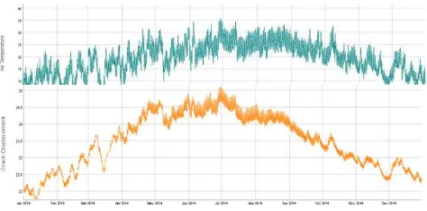
The data collection shows the correlation between temperature and joint displacement (Figure 5). Daily air temperature data of 2014 are compared with rock displacement measured by the sensor 6213 (crack meter of block sector 5-left slope) as example for analysis of displacement trend vs. temperature oscillation.
Figure 5. Air temperature trend (2015) vs. rock displacement trend measured at #6213.
The diagram shows a direct relationship between increase of T° and closure of the joint (ascending trend of displacement). The same trend has been already detected for displacements recorded with the manual crack gauge (manual monitoring) (Margottini and Spizzichino, 2015).
Monitoring data suggest that joint opening and closure are strongly correlated with air cooling and heating. This correlation implies that contraction and expansion of the rock on both sides of the crack manifests in joint opening and closure, as clearly indicated by the diagram of Figure 4. The inverse relationship between joint opening and air temperature for one annual cycle implies that the dominant factor affecting displacements of jointed sandstone material in the 'Siq' is thermo-elastic, the majority of which is recovered by the end of an annual loading cycle and resulting in null or slight permanent deformation.
According to the above and considering that recent inventoried landslides in Petra have occurred in early autumn and late spring time, when the daily temperature records show the highest difference between minimum and maximum data, a further analysis (semi-quantitative) was performed on the effect of daily temperature differences on the triggering of recent rock fall. The analysis was first focused on the rock fall occurred on the 28th May 2015 in the 'Siq' of Petra, sector 11. For this event, it is possible to reconstruct accurately the influence of temperature and humidity on the triggering of the rock fall.
Figure 6. Air temperature (upper diagram) and humidity (lower diagram) trends measured in May 2015. The orange area
corresponds to the time of the rock fall.
The daily temperature difference (28-29 May 2015) is around 14.8°, with a highest difference of 16.7° measured at 6am (29 May 2015);
This data is very high and will be further analyzed in the long-term;
The daily humidity difference (28-29 May 2015) is around 41% (from 9% to 60%);
This data is not anomalous considering that higher difference in daily humidity have been recorded in the 'Siq' of Petra since the beginning of climatic observations. In any case, the event was preceded by a quite dry period with low daily differences in humidity with the exception of 15 May and 21 May 2016, when rainfall occurred in Petra;
The analysis of available seismological data banks (i.e. EMSC-European Mediterranean Seismological Centre, USGS-United States Geological Survey) reports no significant earthquakes capable to trigger rock falls recorded between 25 May and 29 May 2015 in Jordan.
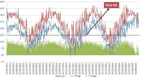
In order to get a wider overview of daily temperature fluctuation in the 'Siq' of Petra, an analysis of temperature data has been carried out since June 2013 up to end of October 2016. All available temperature data have been retrieved from NaturAlert system and transformed in excel format. The complete data set (around 145,000 records) of temperature measurements was restricted to daily maximum and minimum temperature (ca. 2,500 records) and plotted in a graph (Figure 7) reporting maximum temperature, minimum temperature and daily difference (T°).
Figure 7. Trend of air temperature in the 'Siq' of Petra from June 2013 to October 2016.
The above diagram shows that the rock fall event happened on the 28th May 2015 was preceded by the highest daily temperature fluctuation measured since the beginning of the observation (14.8°). The dotted line on 15° (T°) indicates a possible threshold of daily temperature difference that can promote rock failures in the 'Siq' of Petra.
The same analysis was extended also for the other landslides events, reported in Table 2, considering temperature records available for the area (e.g. 'Siq'-Treasury area, Udruh).
Table 2. Overview of displacement recorded by EnvEve SA sensors functioning in October 2016
The results are summarized in the following Table 3.
Table 3. Recent landslide events and possible triggering causes
5. CONCLUSIONS
This study reports on the essential role of monitoring for landslide risk prevention in the 'Siq' of Petra. Among the monitoring devices installed, the wireless system proved to be the most reliable, best performing and feasible system for monitoring rock deformation in the ‘Siq’ of Petra due to its accuracy and possibility to detect rock displacement, mostly if in connection to thermal effects. Additional studies on the data collected combined with a further development of the EASA software could lead to enhancing the potentials of the system. Although not initially designed to work as near-time alarm, the system could progressively lead to the identification of instability thresholds and improve its function as risk preventive measure in Petra. Future actions shall therefore focus on the possibilities of applying the wireless monitoring system also in other areas of the site while reducing its flaws.
Despite some of the challenges faced in the use of the system, as its vulnerability to vandalism and the complexity of installation in the unique geomorphic environment of the ‘Siq’, the implementation of this monitoring system can be regarded as a successful example of landslide risk preventive measure for the improved management of a World Heritage Site. Similar actions shall be then integrated in a management plan for the protection of the site for which is currently being elaborated by UNESCO Amman in cooperation with the national authorities.
ACKNOWLEDGEMENTS
This study has been conducted in the framework of the UNESCO, Italian funded, project "Siq Stability- Mitigation of Immediate Hazards in the Siq of Petra" (Phase II). A special acknowledgement is, thus, addressed to the Italian Agency for Cooperation and Development for having entrusted the UNESCO Amman Office with the implementation of such a strategic project at the Petra World Heritage Site.
continuously cooperation in the implementation of this pioneering project.
REFERENCES
Amireh, B.S., Schneider, W., Abed, A.M. 2001. Fluvial-shallow marine-glaciofluvial depositional environments of the Ordovician System in Jordan. J. Asian Earth Sci.,19, pp. 45–60.
Beck, M., Collet, L. (2011). Jordan and Climate Change. Effects, perceptions and adjustment measures in Jordan. Länderprogramm Jordanien. Konrad-Adenauer-Stiftung e.V., pp. 6. http://www.kas.de/jordanien/en/publications/22643/.
Bender, F. 1974. Geology of Jordan. Gebrueder Bornstraeger, Berlin, pp. 196.
Cesaro, G., Delmonaco, G., Khrisat B., Salis S. 2017. Geological Conservation through Risk Mitigation and Public Awareness at the Siq of Petra, Jordan. In: Sassa, K., Mikoš, M., Yin, Y. (eds), Advancing Culture of Living with Landslides, Vol. 1: The ISDR-ICL Sendai Partnerships 2015-2025. Springer, Heidelberg, ISBN 978-3-319-59469-9, pp. 511-517.
Delmonaco G. (2016). Final report on block dislodgement. Siq Stability Phase II, Technical Report, UNESCO Amman, pp. 100.
Delmonaco, G., Leoni, G., Margottini, C., Spizzichino, D. 2015. Implementation of advanced monitoring system network in the Siq of Petra (Jordan). In: G Lollino et al. (eds.), Engineering Geology for Society and Territory, Vol. 8, Springer Cham Heidelberg New York Dordrecht London, ISBN 978-3-319-09407-6, pp. 299-303.
Delmonaco, G., Margottini, C., Spizzichino, D. 2013a. Rock-Fall Hazard Assessment in the Siq of Petra, Jordan. In: Canuti P, Margottini C, Sassa K (eds.), Landslide Science and Practice, Vol. 6: Risk assessment, management and mitigation. Springer, Heidelberg, ISBN 978-3-632-31312-6, pp. 441-449.
Delmonaco, G., Margottini, C., Spizzichino, D. 2013b. Slope dynamics, monitoring and geological conservation of the Siq of Petra (Jordan). In: Bilotta E, Flora A, Lirer S, Viggiani C (eds.) Geotechnical Engineering for the Preservation of Monuments and Historic Sites. London, Taylor & Francis Group, ISBN: 978-1-138-00055-1, pp. 325-334.
Delmonaco, G., Margottini, C., Spizzichino, D., Dessì, B., Guerrieri, L., Iadanza, C., Leoni, G., Porfidia, B., Trigila, A. 2013c. Siq Stability Project, Activity 1 and 2. Intermediate report. Technical Report, UNESCO Amman, pp. 234.
Delmonaco, G., Margottini, C., Spizzichino, D., Khrisat, B. 2014. Rock slope potential failures in the Siq of Petra (Jordan). In: Sassa K, Canuti P and Yueping Y (eds.) Landslide Science for a Safer Geoenvironment, Targeted landslides. Vol. 3, Springer, ISBN 978-3-319-04995-3, pp. 341-347.
EMSC-European Mediterranean Seismological Centre. https://www.emsc-csem.org/Earthquake/world/. [Last accessed: 31.05.2017].
Gischig, V.S., Moore, J.R., Evans, K.F., Amann, F., Loew, S. 2011. Thermomechanical forcing of deep rock slope
deformation: 1. Conceptual study of a simplified slope. J Geophys. Res. Earth Surf., 116, F04010.
Greif, V., Sassa, K., Fukuoka, H. 2006. Failure mechanism in an extremely slow rock slide at Bitchu-Matsuyama castle site (Japan). Landslide, 3, pp. 22-38.
Gunzburger, Y., Merrien-Soukatchoff, V., Guglielmi, Y. 2005. Influence of daily surface temperature fluctuations on rock slope stability: case study of the Rochers de Valabres slope (France). Int. J. Rock Mech. Min. Sci., 42, pp. 331-349.
Haztor, Y.H., Talesnick, M., Tsesarsky, M. 2002. Continuous and discontinuous stability analysis of the bell-shaped caverns at Bet Guvrin, Israel. Int. J. Rock Mech. Min. Sci., 39, pp. 867-886.
Hatzor, Y.H. 2003. Keyblock stability in seismically active rock slopes – Snake Path cliff, Masada. J. Geotech. Geoenviron. Eng., 129, 697-710.
Iverson, R.M. 2000. Landslide triggering by rain infiltration. Water Resources Research, 36, pp. 1897-1910.
Margottini, C., Spizzichino, D. 2015. Final report on Artificial Neural Networks for weather forecasting. Journal of Taibah University for Science, 7, pp. 44–55.
Matsuoka, N. 2008. Frost weathering and rockwall erosion in the southeastern Swiss Alps: long-term (1994-2006) observations. Geomorphology, 99, pp. 353-368.
Mufundirwa, A., Fujii, Y., Kodama, J. 2011. Analysis of natural rock slope deformations under temperature variation: a case from a temperate region in Japan. Cold Reg. Sci. Tech., 65, pp. 488-500.
Murton, J.B., Peterson, R., Ozouf, J.C. 2006. Bedrock fracture by ice segregation in cold regions. Science, 314, pp. 1127-1129.
Rodriguez, C.E., Bommer, J.J., Chandler, R.J. 1999. Earthquake-induced landslides: 1980-1997. Soil Dynam. Earthq. Eng., 18, pp. 325-346.
Paolini, A., Vafadari, A, Cesaro, G., Santana Quintero, M., Van Balen, K., Vileikis, O., Fakhoury, L. 2012. Risk Management at Heritage Sites: a Case Study of the Petra World Heritage Site, Amman, UNESCO, ISBN 978-92-3-001073-7.
UNESCO, 2006. Issues related to the State of Conservation of World Heritage properties: Strategy for Reducing Risks from Disasters at World Heritage properties, adopted by the Committee at in 30th session. Vilnius (WHC-06/30, COM/7.2, p.1). http://whc.unesco.org/en/disaster-risk-reduction/#strategy [Last accessed: 31.05.2017].
USGS-United States Geological Survey.
https://earthquake.usgs.gov/earthquakes/. [Last accessed:
31.05.2017].
Vargas, J.E., Velloso, R., Chavez, I., Gusmão, I., Amaral, C. 2013. On the effect of thermally induced stresses in failures of some rock slopes in Rio de Janeiro, Brazil. Rock Mech. Rock Eng., 46, pp. 123-134.
Veveakis, E., Vardoulakis, I., Di Toro, G. 2007. Thermoporomechanics of creeping landslides: the 1963 Vajont slide, northern Italy. J. Geophys. Res. Earth Surf. 112, pp. 21.
Vlcko, J., Greif, V., Grof, V., Jezny, M., Petro, L., Brcek, M. 2009. Rock displacement and thermal expansion study at historic heritage sites in Slovakia. Environ. Geol., 58, pp. 1727-1740.
Watson, A.D., Moore, D.P., Stewart, T.W. 2004. Temperature influence on rock slope movements at Checkerboard Creek. In: Lacerda W, Ehrlich M, Fontoura SAB, Sayao AS (eds) Landslides: evaluation and stabilization. 9th Int. Symp. on Landslides. A.A. Balkema Publishers, Leiden, pp. 1293–1298.