Open Geospatial Consortium
Publication Date: 2014-01-22 Approval Data: 2013-12-05 Submission Date: 2013-09-01
Reference URL for this document: www.opengeospatial.net/doc/IS/owc-conceptual/1.0 Internal reference number of this OGC® document: 12-080r2
Version: 1.0 Category: OGC®Implementation Standard Editor(s): Roger Brackin, Pedro Gonçalves
OGC OWS Context Conceptual Model
Copyright notice
Copyright © 2014 Open Geospatial Consortium
To obtain additional rights of use, visit http://www.opengeospatial.org/legal/.
Warning
This document is an OGC Member approved international standard. This document is available on a royalty free, non-discriminatory basis. Recipients of this document are invited to submit, with their comments, notification of any relevant patent rights of which they are aware and to provide supporting documentation.
Document type: OGC® Implementation Standard Document subtype: Conceptual Model
distribute, and/or sublicense copies of the Intellectual Property, and to permit persons to whom the Intellectual Property is furnished to do so, provided that all copyright notices on the intellectual property are retained intact and that each person to whom the Intellectual Property is furnished agrees to the terms of this Agreement.
If you modify the Intellectual Property, all copies of the modified Intellectual Property must include, in addition to the above copyright notice, a notice that the Intellectual Property includes modifications that have not been approved or adopted by LICENSOR. THIS LICENSE IS A COPYRIGHT LICENSE ONLY, AND DOES NOT CONVEY ANY RIGHTS UNDER ANY PATENTS THAT MAY BE IN FORCE ANYWHERE IN THE WORLD.
THE INTELLECTUAL PROPERTY IS PROVIDED "AS IS", WITHOUT WARRANTY OF ANY KIND, EXPRESS OR IMPLIED, INCLUDING BUT NOT LIMITED TO THE WARRANTIES OF MERCHANTABILITY, FITNESS FOR A PARTICULAR PURPOSE, AND NONINFRINGEMENT OF THIRD PARTY RIGHTS. THE COPYRIGHT HOLDER OR HOLDERS INCLUDED IN THIS NOTICE DO NOT WARRANT THAT THE FUNCTIONS CONTAINED IN THE INTELLECTUAL PROPERTY WILL MEET YOUR REQUIREMENTS OR THAT THE OPERATION OF THE INTELLECTUAL PROPERTY WILL BE
UNINTERRUPTED OR ERROR FREE. ANY USE OF THE INTELLECTUAL PROPERTY SHALL BE MADE ENTIRELY AT THE USER’S OWN RISK. IN NO EVENT SHALL THE COPYRIGHT HOLDER OR ANY CONTRIBUTOR OF
OGC 12-080r2
2 Copyright © 2014 Open Geospatial Consortium
Contents
1. Scope ... 7
2. Conformance ... 7
3. References ... 7
4. Terms and Definitions ... 7
4.1 Common Operating Picture ... 8
4.2 Context Document ... 8
4.3 Resource ... 8
4.4 Area of Interest ... 8
5. Conventions ... 8
5.1 Abbreviated Terms ... 8
5.2 UML notation ... 8
5.3 Data dictionary tables ... 9
5.4 Core and Extension Breakdown ... 9
6. Use Cases and Requirements ... 11
6.1 Use Cases ... 11
6.2 Overview of Key Requirements ... 11
6.2.1 Definition of Geographic Area ... 11
6.2.2 Definition of Temporal Interval ... 11
6.2.3 Support a series of Configured Resources ... 12
6.2.4 Order of Configured Resources ... 12
6.2.5 Support Multiple Service Types and Parameters ... 12
6.2.6 Allow Clients to decide if service is supported ... 12
6.2.7 Support for visualization and other client types ... 12
6.2.8 Allow resources to be enabled or disabled ... 12
6.2.9 Association of Information with embedded Content ... 12
6.2.10 Support for In-line Content ... 12
6.2.11 Support for External Content ... 13
6.2.12 Support for Chained Services ... 13
6.2.13 Support for capturing Resource Parameters ... 13
7. OWS Context Conceptual Model ... 1
3 Copyright © 2014 Open Geospatial Consortium
7.2 Core Conceptual Model ... 1
7.2.1 Class ows:Context ... 3
7.2.2 Class owc:Resource ... 5
7.2.3 Datatype owc:Offering ... 8
7.2.4 Datatype owc:Operation ... 9
7.2.5 Datatype owc:Content ... 10
7.2.6 Datatype owc:StyleSet ... 10
7.2.7 Datatype owc:Creator ... 11
7.2.8 Datatype owc:CreatorApplication ... 12
7.2.9 Datatype owc:CreatorDisplay ... 13
7.3 owc:WMS Offering Extension ... 14
7.3.1 Summary of Valid Attributes ... 15
7.3.2 Supported Standards Within This Extension ... 15
7.4 owc:WFS Offering Extension ... 15
7.4.1 Summary of Valid Attributes ... 16
7.4.2 Supported Standards Within This Extension ... 16
7.5 owc:WCS Offering Extenstion ... 16
7.5.1 Summary of Valid Attributes ... 16
7.5.2 Supported Standards Within This Extension ... 17
7.6 owc:WPS Offering Extension ... 17
7.6.1 Summary of Valid Attributes ... 17
7.6.2 Supported Standards Within This Extension ... 18
7.7 owc:CSW Offering Extenstion ... 18
7.7.1 Summary of Valid Attributes ... 18
7.7.2 Supported Standards Within This Extension ... 19
7.8 owc:WMTS Offering Extension ... 19
7.8.1 Summary of Valid Attributes ... 19
7.8.2 Supported Standards Within This Extension ... 20
7.9 owc:GML Offering Extension ... 20
7.9.1 Summary of Valid Attributes ... 20
7.9.2 Supported Standards Within This Extension ... 20
7.10 owc:KML Offering Extension ... 21
7.10.1 Summary of Valid Attributes ... 21
OGC 12-080r2
4 Copyright © 2014 Open Geospatial Consortium
7.11 owc:GeoTIFF Offering Extension ... 21
7.11.1 Summary of Valid Attributes ... 22
7.11.2 Supported Standards Within This Extension ... 22
7.12 owc:GMLJP2 Offering Extension ... 22
7.12.1 Summary of Valid Attributes ... 23
7.12.2 Supported Standards Within This Extension ... 23
7.13 owc:GMLCOV Offering Extension ... 23
7.13.1 Summary of Valid Attributes ... 24
7.13.2 Supported Standards Within This Extension ... 24
A.1 Conformance Test Class: core ... 25
A.1.1 Fully Implements the Content Class ... 26
A.1.2 Fully Implements the CreatorDisplay Class ... 27
A.2 Conformance Test Class: WFS Extension ... 28
A.3 Conformance Test Class: WCS Extension ... 28
A.4 Conformance Test Class: WPS Extension ... 29
A.5 Conformance Test Class: CSW Extension ... 29
A.6 Conformance Test Class: WMTS Extension ... 29
A.7 Conformance Test Class: GML Extension ... 30
A.8 Conformance Test Class: KML Extension ... 30
A.9 Conformance Test Class: GeoTIFF Extension ... 30
A.10 Conformance Test Class: GMLJP2 Extension ... 31
5 Copyright © 2014 Open Geospatial Consortium
i.
Abstract
This standard describes the use cases, requirements and conceptual model for the OWS Context encoding standard. The goal of this standard is to provide a core model, which is extended and encoded as defined in extensions to this standard. A ‘context document’ specifies a fully configured service set which can be exchanged (with a consistent interpretation) among clients supporting the standard.
The OGC Web Services Context Document (OWS Context) was created to allow a set of configured information resources (service set) to be passed between applications primarily as a collection of services. OWS Context is developed to support in-line content as well. The goal is to support use cases such as the distribution of search results, the exchange of a set of resources such as OGC Web Feature Service (WFS), Web Map Service (WMS), Web Map Tile Service (WMTS), Web Coverage Service (WCS) and others in a ‘common operating picture’. Additionally OWS Context can deliver a set of configured processing services (Web Processing Service (WPS)) parameters to allow the processing to be reproduced on different nodes.
OWS Context is aimed at replacing previous OGC attempts at providing such a capability (the Web Map Context WMC) which was reasonably successful but limited to WMS. Other work on the ‘Location Organizer Folder (LOF)’ was also taken into consideration. The concept of OWS Context, and the first prototype document was produced as part of OGC testbed OWS-7. See OGC 10-035r1, Information Sharing Engineering Report. In order to achieve mass market appeal, as well as being useful to a wider community, the use of OWS Context support to other existing standards was considered. Multiple encoding formats for OWS Context have been developed (ATOM, JSON). Each of these is described in a separate OWS Context Extensions to the Core model.
This document concentrates on describing the OWS Context Model in abstract terms using UML. The document defines requirements and use cases. It also includes an abstract test suite to verify that encodings are compliant with the core specification. The intent of OWS Context is to allow many types of OGC Data Delivery service to be referenced and therefore exploited (for example, not just WMS but also WFS, WCS and WPS) but it does not explicitly define the encoding of these services in the core (only the general approach to be used for different types of service interface). Service explicit encodings are defined within the extension documents for ATOM and JSON.
OGC 12-080r2
6 Copyright © 2014 Open Geospatial Consortium
ii.
Keywords
The following are keywords to be used by search engines and document catalogues
Ogcdoc, COP, Common Operating Picture, OWC, Context, OWS Context
iii.
Preface
Attention is drawn to the possibility that some of the elements of this document may be the subject of patent rights. The Open Geospatial Consortium shall not be held responsible for identifying any or all such patent rights.
Recipients of this document are requested to submit, with their comments, notification of any relevant patent claims or other intellectual property rights of which they may be aware that might be infringed by any implementation of the standard set forth in this document, and to provide supporting documentation when possible.
iv.
Submitting organizations
The following organizations submitted this Implementation Standard to the Open Geospatial Consortium as an Implementation Standard:
Envitia
Intergraph
ImageMatters
NGA
Terradue
USGS
v.
Submitters
All questions regarding this submission should be directed to the editor or the submitters:
Name Company
Roger Brackin Envitia
Pedro Gonçalves Terradue
Joan Maso Universitat Autònoma de Barcelona
David Rosinger Intergraph
Raj Singh OGC
Matt Tricomi USGS
David Wesloh NGA
7 Copyright © 2014 Open Geospatial Consortium
1.
Scope
This document defines the conceptual model of the OWS Context document and the intended semantics of each element of the document. It also defines the requirements and the abstract test cases against which encoding specifications using specific carrier standards can be validated as compliant with OWS Context.
2.
Conformance
This document defines a standardisation target for encodings which implement the OWS Context conceptual model in order to allow different encodings to have equivalent content and semantics so that they can be interoperable; it establishes a core requirements
class: http://www.opengis.net/spec/owc/1.0/req/core with URI of
http://www.opengis.net/spec/owc/1.0/req/core as well as a number of extensions, one per chosen service type. Requirements and conformance test URIs defined in this document are relative to http://www.opengis.net/spec/owc/1.0. All requirements in this specification are part of the core requirement stated above.
Conformance with this standard shall be checked using all the relevant tests specified in Annex A (normative) of this document. The framework, concepts, and methodology for testing, and the criteria to be achieved to claim conformance are specified in the OGC Compliance Testing Policies and Procedures and the OGC Compliance Testing web site.
In order to conform to this OGC® interface standard, an encoding standard shall choose to implement any one of the conformance levels specified in Annex A (normative).
3.
References
The following normative documents contain provisions that, through reference in this text, constitute provisions of this document. For dated references, subsequent amendments to, or revisions of, any of these publications do not apply. For undated references, the latest edition of the normative document referred to applies.
1. ISO19115:2003 Metadata Standard for Geographic Information. 2. OGC 08-131r3 - The Specification Model — A Standard for Modular
specifications
4.
Terms and Definitions
OGC 12-080r2
8 Copyright © 2014 Open Geospatial Consortium
4.1 Common Operating Picture
A COP is a single identical display of relevant information shared by more than one command. A common operational picture facilitates collaborative planning and assists all echelons to achieve situational awareness.
4.2 Context Document
A context document is a document describing the set of resources and their configuration, and ancillary information (area of interest, etc.) which defines the information representation of a common operating picture.
4.3 Resource
A resource is a configured set of information which is uniquely identifiable to a user. This can be realised as in-line or external content or by one or more configured web services.
4.4 Area of Interest
An area of interest is a geographic area which is significant to a user.
5.
Conventions
This sections provides details and examples for any conventions used in the document. Examples of conventions are symbols, abbreviations, use of XML schema, or special notes regarding how to read the document.
5.1 Abbreviated Terms
owc - OGC Web Services Context
5.2 UML notation
Unified Modeling Language (UML) static structure diagrams appearing in this specification are used as described in Sub clause 5.2 of OGC Web Service Common [OGC 06-121r9]. Further, the following conventions hold:
UML elements having a package name of “OWS Common” are those defined in the UML model of OWS Common [OGC 06-121r9].
9 Copyright © 2014 Open Geospatial Consortium UML elements not qualified with a package name are those defined in this
Standard.
UML data type Any is used here as an equivalence to XML’s xsd:any.
5.3 Data dictionary tables
The UML model data dictionary is specified herein in a series of tables. The contents of the columns in these tables are described in Sub clause 5.5 of [OGC 06-121r9]. The contents of these data dictionary tables are normative, including any table footnotes. For the reader’s convenience, table rows describing inherited components are shaded.
5.4 Core and Extension Breakdown
OGC 12-080r2
10 Copyright © 2014 Open Geospatial Consortium
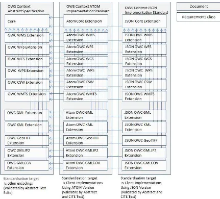
Figure 1 - OWS Context Requirement Class and Document Breakdown
The core context document is largely agnostic of any particular resource type, covering the basic structure and the extension model. A requirement class is then defined for each resource offering. This document covers all of the requirement classes for the conceptual model (the left grey box in figure 1 above). These standardization target resources include services (WMS, WFS), encodings for in-line content (GML, GeoTiff) and storage for external content (GeoPackage).
Various potential OWS Context encodings have been considered, in particular there are clear requirements for both an XML (Atom) encoding and a JSON Encoding. These are the subject of separate documents (Implementation Specifications).
11 Copyright © 2014 Open Geospatial Consortium
6.
Use Cases and Requirements
The Context Document goal is to support the exchange of a common operating picture or view between human users or applications such that the area of interest, time range, resources and their configuration is unambiguously exchanged between applications.
6.1 Use Cases
The OWS Context document is aimed at meeting a range of user context exchange requirements around shared situational awareness. Possible uses of the context document include:
1. Exchange of a common view or common operating picture for shared situational awareness.
2. Exchange of discovery results from various catalogue searches, to avoid duplication of effort.
3. Exchange of configuration and/or results of an analysis or processing activity
The exchange of a common operating picture is recognized as the most important usage of the OWS Context Document. As part of this there is the recognition that in some cases the services referenced may not be available.Therefore information outputs from services may be included as in-line content or referenced as external content in a container such as a GeoPackage, andsome descriptive information (for example overlays or thumbnails) may need to be carried in the context document itself or alongside it.
6.2 Overview of Key Requirements
The above use cases lead to the following general requirements for an OWS Context document. All of these requirements are implicit in the core requirement class
http://www.opengis.net/spec/owc/1.0/req/core shown (and detailed in section 7).
6.2.1 Definition of Geographic Area
The Context Document shall provide the capability to identify the geographic area of interest of the common operating picture.
Requirement: http://www.opengis.net/spec/owc/1.0/req/core/ContextClass
6.2.2 Definition of Temporal Interval
The Context Document shall provide the capability to identify the temporal extent of the COP (one or more time envelopes).
OGC 12-080r2
12 Copyright © 2014 Open Geospatial Consortium
6.2.3 Support a series of Configured Resources
The Context Document shall provide the capability to define a series of configured resources together which provide relevant information to the COP User.
Requirement: http://www.opengis.net/spec/owc/1.0/req/core/ContextClass
6.2.4 Order of Configured Resources
The Context Document shall define the order of precedence of the resources included (this could be interpreted as, for example, the order of display by visualization clients)
Requirement: http://www.opengis.net/spec/owc/1.0/req/core/ContextClass.
6.2.5 Support Multiple Service Types and Parameters
The Context Document shall allow any service type to be specified and any rules to be specified.
Requirement: http://www.opengis.net/spec/owc/1.0/req/core/ResourceClass
6.2.6 Allow Clients to decide if service is supported
The Context Document shall provide information to allow clients to test if a service matches a supported profile in order to understand if they can interpret it.
Requirement: http://www.opengis.net/spec/owc/1.0/req/core/OfferingClass
6.2.7 Support for visualization and other client types
The Context Document shall allow information targeted at different representations to be included (i.e. not just targeted at geographic visualization or just visualization).
Requirement: http://www.opengis.net/spec/owc/1.0/req/core/StyleSet
6.2.8 Allow resources to be enabled or disabled
The Context Document shall allow information to be marked as enabled or disabled, i.e. it is to be presented to the user when the context is opened or it isn’t. Source: WMC Specification: which has an on/off option (layer displayed or not when loaded).
Requirement: http://www.opengis.net/spec/owc/1.0/req/core/ResourceClass
6.2.9 Association of Information with embedded Content
It shall be possible to associate information (e.g. styling) with embedded content, e.g. GML.
Requirement: http://www.opengis.net/spec/owc/1.0/req/core/ResourceClass
6.2.10 Support for In-line Content
13 Copyright © 2014 Open Geospatial Consortium Requirement: http://www.opengis.net/spec/owc/1.0/req/core/ResourceClass
6.2.11 Support for External Content
The Context Document should allow reference to a literal value of a resource in a container external to the context document.
Requirement: http://www.opengis.net/spec/owc/1.0/req/core/ResourceClass
6.2.12 Support for Chained Services
The Context Document should allow the definition of a chain of processing services in order to define a resource. Not included in version 1 of the specification.
6.2.13 Support for capturing Resource Parameters
The Context Document should allow the parameters which define the resource or processing service steps to be captured.
7.
OWS Context Conceptual Model
7.1 Overview
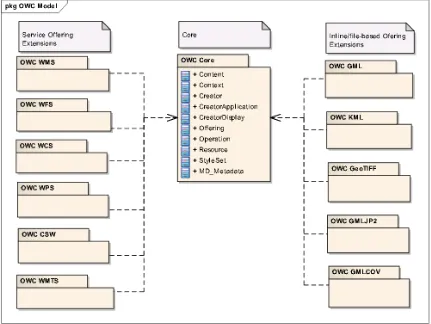
This clause specifies the underlying OWS Context conceptual model for which an encoding can be created. It defines the mandatory requirements for context encoding and the necessary semantics of how that encoding should be interpreted. The conceptual model is broken down into various packages. These are shown in Figure 1 below.
Figure 2 – OWS Context Standard Packages
7.2 Core Conceptual Model
The requirements within this section fall within the ows context core requirement class.
Requirement Class: http://www.opengis.net/spec/owc/1.0/req/core
Scope: All requirements in this subsection relate to the above requirement class.
Dependencies: None
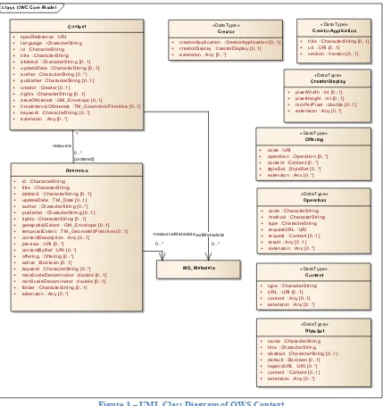
Description: The OWS Context conceptual model is shown in the UML
2 Copyright © 2014 Open Geospatial Consortium
Figure 3 – UML Class Diagram of OWS Context
The role of each class and attribute in the model above is described in the tables below. cla WC Core Model
Coex
+ specReference :URI + language :CharacterString + id :CharacterString + title :CharacterString + abstract :CharacterString [0..1] + updateDate :CharacterString [0..1] + author :CharacterString [0..*] + publisher :CharacterString [0..1] + creator :Creator [0..1] + rights :CharacterString [0..1] + areaOfInterest :GM_Envelope [0..1]
+ timeIntervalOfInterest :TM_GeometricPrimitive [0..1] + keyword :CharacterString [0..*]
+ extension :Any [0..*]
Re ource
+ id :CharacterString + title :CharacterString + abstract :CharacterString [0..1] + updateDate :TM_Date [0..1] + author :CharacterString [0..*] + publisher :CharacterString [0..1] + rights :CharacterString [0..1] + geospatialExtent :GM_Envelope [0..1] + temporalExtent :TM_GeometricPrimitive [0..1] + contentDescription :Any [0..1]
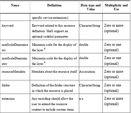
+ preview :URI [0..*] + contentByRef :URI [0..*] + offering :Offering [0..*] + active :Boolean [0..1] + keyword :CharacterString [0..*] + maxScaleDenominator :double [0..1] + minScaleDenominator :double [0..1] + folder :CharacterString [0..1] + extension :Any [0..*]
MD_Me adaa
«DataType»
S yleSe
+ name :CharacterString + title :CharacterString + abstract :CharacterString [0..1] + default :Boolean [0..1]
+ operation :Operation [0..*] + content :Content [0..*] + styleSet :StyleSet [0..*] + extension :Any [0..*]
«DataType»
Operaio
+ code :CharacterString + method :CharacterString + type :CharacterString + requestURL :URI
+ type :CharacterString + URL :URI [0..1] + mmPerPixel :double [0..1] + extension :Any [0..*]
«DataType»
CreaorAppica i
o
+ title :CharacterString [0..1] + uri :URI [0..1] + version :Version [0..1]
«DataType»
Creaor
OGC 12-080r2
3 Copyright © 2014 Open Geospatial Consortium
7.2.1 Class ows:Context
Requirement ID: http://www.opengis.net/spec/owc/1.0/req/core/ContextClass
Requirement Txt: Implementations shall support the encoding of all of the mandatory and optional parameters of the Context Class and meet all of the tabulated constraints and notes
This class is the overall container class for the context document. Its properties are documented below.
Name Definition Data type and
Value
Multiplicity and Use
specReference Specification Reference identifying
that this is an owc Context
document
URI One (mandatory)
language Language used in the owc Context
document
CharacterString One (mandatory)
id Unique Identifier assigned to the
OWS Context Document
CharacterString One (mandatory)
title A Human Readable Title for the
OWS Context Document
CharacterString One (mandatory)
abstract Description of the Context
Document Purpos Content
CharacterString Zero or one
(optional)
updateDate Date when the Context Document
was updated
CharacterString Zero or one
(optional)
author Identifier for the author of the
document
CharacterString Zero or more
(optional)
publisher Identifier for the publisher of the
document
CharacterString Zero or one
(optional)
creator The toolapplication used to create
the context document and its
properties
4 Copyright © 2014 Open Geospatial Consortium
Name Definition Data type and
Value
Multiplicity and Use
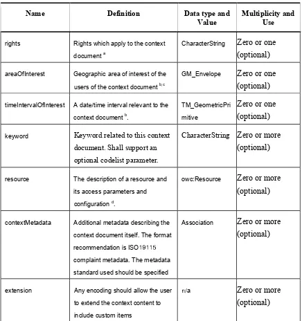
rights Rights which apply to the context
document a
CharacterString Zero or one
(optional)
areaOfInterest Geographic area of interest of the
users of the context document b,c
GM_Envelope Zero or one
(optional)
timeIntervalOfInterest A dat time interval relevant to the
context document b.
TM_GeometricPri
mitive
Zero or one
(optional)
keyword Keyword related to this context document. Shall support an optional codelist parameter.
CharacterString Zero or more (optional)
resource The description of a resource and
its access parameters and
configuration d.
owc:Resource Zero or more
(optional)
contextMetadata Additional metadata describing the
context document itself. The format
recommendation is ISO1 1 1
complaint metadata. The metadata
standard used should be specified
Association Zero or more
(optional)
extension Any encoding should allow the user
to extend the context content to
include custom items
na Zero or more
(optional)
Table 1- Context Class Properties
a
The rights described apply to the Context Document itself not to any of its contents.
b
OGC 12-080r2
5 Copyright © 2014 Open Geospatial Consortium
c
The Coordinate Reference System shall be unambiguous. It should either be implicit in
the choice of encoding of an area of interest or explicitly defined.
d
Resources are ordered. Clients would normally interpret this in terms of display order.
How the encoding defines the order of layers in relation to display shall be defined in the
encoding specification.
7.2.2 Class owc:Resource
Requirement ID: http://www.opengis.net/spec/owc/1.0/req/core/ResourceClass
Requirement Txt: Implementations shall support the encoding of all of the mandatory and optional parameters of the Resource Class and meet all of the tabulated constraints and notes
This class describes the resource elements which supply the information layers used in the Context Document. Resource, while it can be used bare, is typically classified by owc:MediaCode indicating the type of information encoded in the resource. The resource offers multiple ways to pass a configured resource, in-line content, by absolute URI and by service Content which needs to be interpreted by an intelligent client. While there may be limitations in the individual encoding, each of these types shall be semantically equivalent, i.e. alternative representations of the same information (they can for example have different resolutions but should not show fundamentally different information).
Name Definition Data type and
Value
Multiplicity and Use
id Unique Identifier assigned to the owc Resource. Used to reference a resource from other resources
CharacterString One (mandatory)
title A Human Readable Title for the owc Resource.
CharacterString One (mandatory)
abstract Description of the Context Document Purpose/Content
CharacterString Zero or one (optional)
updateDate Date when the resource definition was updated
CharacterString Zero or one (optional)
6 Copyright © 2014 Open Geospatial Consortium
Name Definition Data type and
Value
Multiplicity and Use
resource definition (optional)
publisher Identifier for the publisher of the resource definition
CharacterString Zero or one (optional)
rights Rights which apply to the resource definitiona
CharacterString Zero or one (optional)
geospatialExtent The geographic extent of the resourceb
GM_Envelope Zero or one (optional)
temporalExtent The temporal extent of the content of the resource c
TM_GeometricP rimitive
Zero or one
(optional)
contentDescription A reference to a description of the Context resource in alternative format.
Any Zero or one (optional)
preview A URI identifying a preview of the resource
URI Zero or more (optional)
contentByRef A URI identifying a service which will return an immediately exploitable result by simply requesting based on the URI. The expectation is that the return type of this call will be a well-known format
URI Zero or more (optional)
offering Service or inline content offering for the resource targeted at OGC compliant clients
owc:OfferingTy pe
Zero or more
(optional)
active This flag indicates the state of the resource within the context document. It can be interpreted by the caller as required (this may be defined in a profile or in the
Boolean
Default=TRUE
Zero or one
OGC 12-080r2
7 Copyright © 2014 Open Geospatial Consortium
Name Definition Data type and
Value
Multiplicity and Use
specific service extensions)
keyword Keyword related to this resource definition. Shall support an optional codelist parameter.
CharacterString Zero or more (optional)
minScaleDenomina tor
Minimum scale for the display of the layer d.
double Zero or one (optional)
maxScaleDenomin ator
Maximum scale for the display of the layer d.
double Zero or one (optional)
resourceMetadata Metadata about the resource itself Association Zero or more (optional)
folder Definition of the folder structure in which the resource is placed.
CharacterString Zero or one (optional)
extension Any encoding should allow the user to extend the resource content to include custom items
n/a Zero or more (optional)
Table 2- Resource Class Properties
a
The semantics of rights is not defined here and needs to be defined in extension
packages.
b
The geospatial extent indicates to a client that data that intersects with this area needs to
be retrieved and, if relevant portrayed. There is no specific requirement to hard clip the
data to this boundary.
c
The temporal extent indicates to a client that data that intersects with this time interval
needs to be retrieved, and, if relevant, portrayed. There is no specific requirement to hard
clip the data to this boundary.
d
8 Copyright © 2014 Open Geospatial Consortium of 0.28 mm × 0.28 mm (millimeters). The definition is the same used in WMS 1.3.0
[OGC 06-042] and in Symbology Encoding Implementation Specification 1.1.0
[05-077r4]. Frequently, the true pixel size is unknown and 0.28 mm is a common actual size
for current displays.
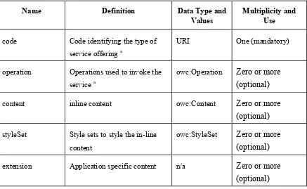
7.2.3 Datatype owc:Offering
Requirement ID: http://www.opengis.net/spec/owc/1.0/req/core/OfferingClass
Requirement Txt: Implementations shall support the encoding of all of the mandatory and optional parameters of the Offering Class and meet all of the tabulated constraints and notes
This datatype class defines the properties of a specific service binding or inline content for an offering. The service binding is primarily characterized by a series of parameters. The parameters valid for a specific type of service binding, e.g. WFS are defined outside of the OWS Context core specification. Each specific service binding is defined by a URI which references a requirement class.
Name Definition Data Type and
Values
Multiplicity and Use
code Code identifying the type of service offering a
URI One (mandatory)
operation Operations used to invoke the service a
owc:Operation Zero or more (optional)
content inline content owc:Content Zero or more (optional)
styleSet Style sets to style the in-line content
owc:StyleSet Zero or more (optional)
extension Application specific content n/a Zero or more (optional)
Table 3- Offering Class Properties
a
Operations of a specific service request should be defined in a separate extension of this
OGC 12-080r2
9 Copyright © 2014 Open Geospatial Consortium
changing the core service offering type. Any modification of the parameter field types or
semantics would require a new service offering code value.
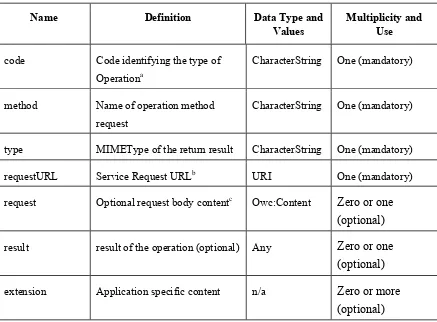
7.2.4 Datatype owc:Operation
Requirement ID: http://www.opengis.net/spec/owc/1.0/req/core/OperationClass
Requirement Txt: Implementations shall support the encoding of all of the mandatory and optional parameters of the Operation Class and meet all of the tabulated constraints and notes
Definition of the operation either to get the information or to get the capabilities. Note
that service specific extension requirements may mandate more than one owc:operation.
Name Definition Data Type and
Values
Multiplicity and Use
code Code identifying the type of Operationa
CharacterString One (mandatory)
method Name of operation method request
CharacterString One (mandatory)
type MIMEType of the return result CharacterString One (mandatory)
requestURL Service Request URLb URI One (mandatory)
request Optional request body contentc Owc:Content Zero or one (optional)
result result of the operation (optional) Any Zero or one (optional)
extension Application specific content n/a Zero or more (optional)
Table 4- Operation Class Properties
a Typically the OGC Service request type, e.g. "GetCapabilities" or "GetMap".
10 Copyright © 2014 Open Geospatial Consortium c Note not necessarily XML (defined by MIMEType).
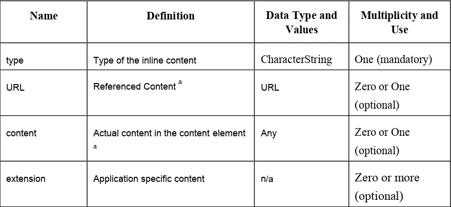
7.2.5 Datatype owc:Content
Requirement ID: http://www.opengis.net/spec/owc/1.0/req/core/ContentClass
Requirement Txt: Implementations shall support the encoding of all of the mandatory
and optional parameters of the Content Class and meet all of the
tabulated constraints and notes
Name Definition Data Type and
Values
Multiplicity and Use
type Type of the inline content CharacterString One (mandatory)
URL Referenced Content a URL Zero or One
(optional)
content Actual content in the content element a
Any Zero or One (optional)
extension Application specific content n/ Zero or more
(optional)
Table 5- Content Class Properties
a:
URL and content elements are mutually exclusive, and the provision of one is
mandatory. One and only one of URL or content should be populated in a specific
content element (i.e a content element must either have content or reference content).
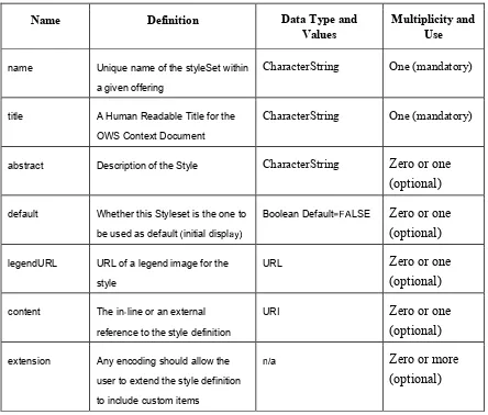
7.2.6 Datatype owc:StyleSet
Requirement ID: http://www.opengis.net/spec/owc/1.0/req/core/StyleSetClass
OGC 12-080r2
11 Copyright © 2014 Open Geospatial Consortium
This datatype class defines a portrayal style for a resource content or serviceContent element. It can be specified at a resource level or at a service offering level (when it only applies to the offering.
Name Definition Data Type and
Values
Multiplicity and Use
name Unique name of the styleSet within
a given offering
CharacterString One (mandatory)
title A Human Readable Title for the
OWS Context Document
CharacterString One (mandatory)
abstract Description of the Style CharacterString Zero or one (optional)
default Whether this Styleset is the one to
be used as default initial displ
Boolean Default= LSE Zero or one
reference to the style definition
URI Zero or one
(optional)
extension Any encoding should allow the
user to extend the style definition
to include custom items
a Zero or more
(optional)
Table 6- StyleSet Class Properties
Note: StyleSet cannot be derived from the service request, and it is a list of relevant styles which could be applied if the service supports dynamic styling, for example if the WMS is an FPS and supports SLD. The intention is that the client could visualize the layer using the getMap Call (which would have a defined styling) but could also offer the user a selection of alternative styles for the layer. These would be derived from the style list parameter.
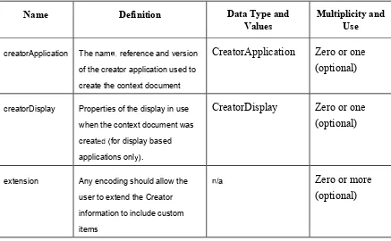
7.2.7 Datatype owc:Creator
12 Copyright © 2014 Open Geospatial Consortium
Requirement Txt: Implementations shall support the encoding of all of the mandatory and optional parameters of the Creator Class and meet all of the tabulated constraints and notes
This datatype class provides place to encode information related to the creator of the con text document. It includes the creator application and any relevant properties or settings for the application.
Name Definition Data Type and
Values
Multiplicity and Use
creatorApplication The nam reference and version
of the creator application used to
create the context document
CreatorApplication Zero or one
(optional)
creatorDisplay Properties of the display in use
when the context document was
creatfor display based
applications onl .
CreatorDisplay Zero or one
(optional)
extension Any encoding should allow the
user to extend the Creator
information to include custom
items
a Zero or more
(optional)
Table 7- Creator Class Properties
7.2.8 Datatype owc:CreatorApplication
Requirement ID:
http://www.opengis.net/spec/owc/1.0/req/core/CreatorApplication
Class
OGC 12-080r2
13 Copyright © 2014 Open Geospatial Consortium
This datatype class provides place to encode information related to the creator context when the document was produced. It includes the creator application and relevant properties or settings for the application.
Name Definition Data Type and
Values
Multiplicity and Use
title Title or name of the applicati for
display purposes)
CharacterString Zero or one
(optional)
uri URI describing the creator
application.
URI Zero or one
(optional)
version Version of the application. CharacterString Zero or one
(optional)
Table 8- CreatorApplication Class Properties
7.2.9 Datatype owc:CreatorDisplay
Requirement ID: http://www.opengis.net/spec/owc/1.0/req/core/CreatorDisplayClass
Requirement Txt: Implementations shall support the encoding of all of the mandatory and optional parameters of the CreatorDisplay Class and meet all of the tabulated constraints and notes
This datatype class provides place to encode information related to the display area used in the creator application when the OWS Context document was produced. This set of properties only applies to creator applications which are using a geographic display and is supporting information to the exploiter of the OWS Context document. Note the elements within creator display are intended as supporting information (metadata) for clients and not properties which should control the display size of the client opening the document.
Name Definition Data Type and
Values
Multiplicity and Use
pixelWidth Pixel width of the display specified
by Area of Interest.
Integer Zero or one
14 Copyright © 2014 Open Geospatial Consortium
Name Definition Data Type and
Values
Multiplicity and Use
pixelHeight Pixel height of the display
specified by Area of Interest.
Integer Zero or one
(optional)
mmPerPixel The number of mm per pixel for
the display. If no value is available
the field should be set toULL.
Double Zero or one
(optional)
extension Any encoding should allow the
user to extend the display
information to include custom
items
!a Zero or more
(optional)
Table 9- CreatorDisplay Class Properties
7.3 owc:WMS Offering Extension
This class describes the extension to the OWS Context Core which supports Web Map
Service Extensions (WMS) offerings.
Requirement Class: http://www.opengis.net/spec/owc/1.0/req/wms
Scope: All requirements in this subsection relate to the above requirement class)
Dependencies: http://www.opengis.net/spec/owc/1.0/req/core
Description: This class describes the extension to the OWS Context Core which
supports Web Map Service (WMS) Service offerings.
Requirement ID: http://www.opengis.net/spec/owc/1.0/req/wms/GetCapabilities
Requirement Txt: Encodings of OWS Context for this extension will require the encoding of only one GetCapabilities request in an offering.
Requirement ID: http://www.opengis.net/spec/owc/1.0/req/wms/GetMap
Requirement Txt: Encodings of OWS Context for this extension will require the encoding of one and only one GetMap request in an offering.
Requirement ID: http://www.opengis.net/spec/owc/1.0/req/wms/content
OGC 12-080r2
15 Copyright © 2014 Open Geospatial Consortium
Requirement ID: http://www.opengis.net/spec/owc/1.0/req/wms/styles
Requirement Txt: Where additional styles are provided the client shall treat these as alternatives to any style specifically encoded in the GetMap call (e.g SLD reference). There is no specific requirement for the client to use these. 7.3.1 Summary of Valid Attributes
Attribute Value Constraint
operation GetCapabilities One (mandatory)
operation GetMap One (mandatory)
content " Z # $o (forbidde% &
style SLD or Txt Z # $o or mor#(optional&
7.3.2 Supported Standards Within This Extension
1. WMS 1.3.0 Web Map Service (06-042) 2. WMS 1.1.1 Web Map Service (01-068r3)
3. SLD-WMS 1.1.0 Styled Layer Descriptor Profile (05-078r4)
7.4 owc:WFS Offering Extension
This class describes the extension to the OWS Context Core which supports Web Feature Service (WFS) Service offerings.
Requirement Class: http://www.opengis.net/spec/owc/1.0/req/wfs
Scope: All requirements in this subsection relate to the above requirement class)
Dependencies: http://www.opengis.net/spec/owc/1.0/req/core
Requirement ID: http://www.opengis.net/spec/owc/1.0/req/wfs/GetCapabilities
Requirement Txt: Encodings of OWS Context for this extension will require the encoding of a one and only one GetCapabilities request in an offering.
Requirement ID: http://www.opengis.net/spec/owc/1.0/req/wfs/GetFeature
Requirement Txt: Encodings of OWS Context for this extension will require the encoding of one and only one GetFeature request in an offering.
Requirement ID: http://www.opengis.net/spec/owc/1.0/req/wfs/content
16 Copyright © 2014 Open Geospatial Consortium
7.4.1 Summary of Valid Attributes
Attribute Value Multiplicity
operation GetCapabilities One (mandatory)
operation GetFeature One (mandatory)
content ' * + . 02forbid d +3 4
style SLD or Txt * + .o or mor+2optional4
7.4.2 Supported Standards Within This Extension
4. WFS 2.0 Web Feature Service 2.0 (also ISO 19142) (09-025r1) 5. WFS 1.1.0 Web Feature Service (04-094)
6. WFS 1.0.0 Web Feature Service (02-058) 7.5 owc:WCS Offering Extenstion
This class describes the extension to the OWS Context Core which supports Web Coverage Service (WCS) offerings.
Requirement Class: http://www.opengis.net/spec/owc/1.0/req/wcs
Scope: All requirements in this subsection relate to the above requirement class
Dependencies: http://www.opengis.net/spec/owc/1.0/req/core
Requirement ID: http://www.opengis.net/spec/owc/1.0/req/wcs/GetCapabilities
Requirement Txt: Encodings of OWS Context for this extension will require the encoding of a one and only one GetCapabilities request in an offering.
Requirement ID: http://www.opengis.net/spec/owc/1.0/req/wcs/GetCoverage
Requirement Txt: Encodings of OWS Context for this extension will require the encoding of one and only one GetCoverage request in an offering.
Requirement ID: http://www.opengis.net/spec/owc/1.0/req/wcs/content
Requirement Txt: Encodings of OWS Context for this extension will exclude the encoding of owc:content in an offering.
OGC 12-080r2
17 Copyright © 2014 Open Geospatial Consortium
Attribute Value Multiplicity
operation GetCapabilities One 5mandator6 7
operation GetCoverage One 5mandator6 7
content 8 9 : ; <5forbi> > : ?7
style SLD or Txt 9 : ;o or mor:5optional7
7.5.2 Supported Standards Within This Extension
1. WCS 2.0 Web Coverage Standard 2.0 - Core (09-110r3) 2. WCS 1.1.0 Web Coverage Service (WCS) (06-083r8) 3. WCS 1.0 Web Coverage Service (WCS) (03-065r6)
7.6 owc:WPS Offering Extension
This class describes the extension to the OWS Context Core which supports Web Processing Service (WPS) offerings.
Requirement Class: http://www.opengis.net/spec/owc/1.0/req/wps
Scope: All requirements in this subsection relate to the above requirement class
Dependencies: http://www.opengis.net/spec/owc/1.0/req/core
Requirement ID: http://www.opengis.net/spec/owc/1.0/req/wps/GetCapabilities
Requirement Txt: Encoding of OWS Context for this extension will require the encoding of a one and only one GetCapabilities request in an offering.
Requirement ID: http://www.opengis.net/spec/owc/1.0/req/wps/Execute
Requirement Txt: Encoding of OWS Context for this extension will require the encoding of one and only one Execute request in an offering.
Requirement ID: http://www.opengis.net/spec/owc/1.0/req/wps/content
Requirement Txt: Encoding of OWS Context for this extension will exclude the encoding of owc:content in an offering.
7.6.1 Summary of Valid Attributes
Attribute Value Multiplicity
operation GetCapabilities One 5mandator6 7
18 Copyright © 2014 Open Geospatial Consortium
Attribute Value Multiplicity
content @ A B C DEforbiG G B HI
style SLD or Txt A B Co or morBEoptionalI
7.6.2 Supported Standards Within This Extension
1. WPS 1.0.0 Web Processing Service (05-007r7)
7.7 owc:CSW Offering Extenstion
This class describes the extension to the OWS Context Core which supports Catalogue
Services (CSW) offerings.
Requirement Class: http://www.opengis.net/spec/owc/1.0/req/csw
Scope: All requirements in this subsection relate to the above requirement class
Dependencies: http://www.opengis.net/spec/owc/1.0/req/core
Requirement ID: http://www.opengis.net/spec/owc/1.0/req/csw/GetCapabilities
Requirement Txt: Encodings of OWS Context for this extension will require the encoding of a one and only one GetCapabilities request in an offering.
Requirement ID: http://www.opengis.net/spec/owc/1.0/req/csw/GetRecords
Requirement Txt: Encodings of OWS Context for this extension will require the encoding of one and only one GetRecords request in an offering.
Requirement ID: http://www.opengis.net/spec/owc/1.0/req/csw/content
Requirement Txt: Encodings of OWS Context for this extension will exclude the encoding of owc:content in an offering.
7.7.1 Summary of Valid Attributes
Attribute Value Multiplicity
operation GetCapabilities OH BEmandator
JI
operation GetRecords One EmandatorJI
content @ A B C DEforbiG G B HI
OGC 12-080r2
19 Copyright © 2014 Open Geospatial Consortium
7.7.2 Supported Standards Within This Extension
1. CSW 2.0.2 Catalogue Service IS (07-006r1) 7.8 owc:WMTS Offering Extension
This class describes the extension to the OWS Context Core which supports Web Map
Tiling Service Extensions (WMTS) offerings.
Requirement Class: http://www.opengis.net/spec/owc/1.0/req/wmts
Scope: All requirements in this subsection relate to the above requirement class
Dependencies: http://www.opengis.net/spec/owc/1.0/req/core
Requirement ID: http://www.opengis.net/spec/owc/1.0/req/wmts/GetCapabilities
Requirement Txt: Encodings of OWS Context for this extension will require the encoding of a one and only one GetCapabilities request in an offering.
Requirement ID: http://www.opengis.net/spec/owc/1.0/req/wmts/GetTile
Requirement Txt: Encodings of OWS Context for this extension will require the encoding of one or more GetTile requests in an offering to satisfy one information request.
Requirement ID: http://www.opengis.net/spec/owc/1.0/req/wmts/content
Requirement Txt: Encodings of OWS Context for this extension will exclude the encoding of owc:content in an offering.
7.8.1 Summary of Valid Attributes
Attribute Value Multiplicity
operation GetCapabilities One KmandatorL M
operation GetTile a One KmandatorL M
content N O P Q R
KforbiT T PUM
style Txt O P Qo or morPKoptionalM
a
The WMTS requires multiple tiles to satisfy one viewing request. However the purpose
of GetTile here is to pass relevant parameters which the client can use to prepare the
20 Copyright © 2014 Open Geospatial Consortium
7.8.2 Supported Standards Within This Extension
1. WMTS 1.0.0 Web Map Tile Service (07-057r7) 7.9 owc:GML Offering Extension
This class describes the extension to the OWS Context Core which supports inline or
referenced GML offerings; this can include referencing local files or into databases.
Requirement Class: http://www.opengis.net/spec/owc/1.0/req/gml
Scope: All requirements in this subsection relate to the above requirement class
Dependencies: http://www.opengis.net/spec/owc/1.0/req/core
Requirement ID: http://www.opengis.net/spec/owc/1.0/req/gml/content
Requirement Txt: An encoding of this extension shall use the content element to capture the GML content. No operation elements should be present.
Requirement ID: http://www.opengis.net/spec/owc/1.0/req/gml/style
Requirement Txt: An encoding of this content shall allow the encoding of associated style information, including specification of a default.
7.9.1 Summary of Valid Attributes
Attribute Value Multiplicity
operation V W X Y [\forbi] ] X^ _
content GML Content inVline or local
reference
One \mandator`_
style SLD or Txt W X Yo or morX\optional_
7.9.2 Supported Standards Within This Extension
1. GML 3.3 Geography Markup Language (GML) (10-129r1) 2. GML 3.2.1 Geography Markup Language (GML) (07-036) 3. GML 3.1.1 Geography Markup Language (GML) (03-105r1) 4. GML 3.0 Geography Markup Language (GML) (02-023r4) 5. GML 2.1.2 Geography Markup Language (02-069)
OGC 12-080r2
21 Copyright © 2014 Open Geospatial Consortium
7.10 owc:KML Offering Extension
This class describes the extension to the OWS Context Core which supports in-line or referenced KML offerings ; this can include referencing local files or into databases.
Requirement Class: http://www.opengis.net/spec/owc/1.0/req/kml
Scope: All requirements in this subsection relate to the above requirement class
Dependencies: http://www.opengis.net/spec/owc/1.0/req/core
Requirement ID: http://www.opengis.net/spec/owc/1.0/req/kml/content
Requirement Txt: An encoding of this extension shall use the content element to capture the KML content. No operation elements should be present.
Requirement ID: http://www.opengis.net/spec/owc/1.0/req/kml/style
Requirement Txt: An encoding of this content shall not allow the encoding of associated style information as it is present within the KML
Document body.
7.10.1 Summary of Valid Attributes
Attribute Value Multiplicity
operation b c f g hiforbij j fk l
content mML Content inbline or local
reference
One imandatorql
style b c f g hiforbij j fk l
7.10.2 Supported Standards Within This Extension 1. KML 2.2.0 OGC KML (07-147r2)
7.11 owc:GeoTIFF Offering Extension
This class describes the extension to the OWS Context Core which supports in-line or referenced GeoTIFF offerings. ; this can include referencing local files or into databases.
Requirement Class: http://www.opengis.net/spec/owc/1.0/req/geotiff
22 Copyright © 2014 Open Geospatial Consortium
Dependencies: http://www.opengis.net/spec/owc/1.0/req/core
Requirement ID: http://www.opengis.net/spec/owc/1.0/req/geotiff/content
Requirement Txt: An encoding of this extension shall use the content element to reference a GeoTIFF file. No operation elements should be present.
Requirement ID: http://www.opengis.net/spec/owc/1.0/req/GeoTIFF/style
Requirement Txt: An encoding of this content shall not allow the encoding of associated style information, as none is required to visualize a
GeoTIFF image.
7.11.1 Summary of Valid Attributes
Attribute Value Multiplicity
operation s t v w z{forbi| | v} ~
content Local reference to a GeoTI
ile
One {mandator~
style s t v w z{forbi| | v} ~
7.11.2 Supported Standards Within This Extension
GeoTIFF Revision 1.0 ( www.pubdoc.org/fileformat/rasterimage/tiff/geotiff.pdf)
7.12 owc:GMLJP2 Offering Extension
This class describes the extension to the OWS Context Core which supports in-line and referenced GMLJP2 offerings; this can include referencing local files or into databases.
Requirement Class: http://www.opengis.net/spec/owc/1.0/req/gmljp2
Scope: All requirements in this subsection relate to the above requirement class
Dependencies: http://www.opengis.net/spec/owc/1.0/req/core
Requirement ID: http://www.opengis.net/spec/owc/1.0/req/gmljp2/content
Requirement Txt: An encoding of this extension shall use the content element to reference a GMLJP2 file. No operation elements should be present.
OGC 12-080r2
23 Copyright © 2014 Open Geospatial Consortium
Requirement Txt: An encoding of this content shall not allow the encoding of associated style information, as none is required to visualize a GMLJP2 image.
7.12.1 Summary of Valid Attributes
Attribute Value Multiplicity
operation forbi
content Local reference to a GM P
ile
One mandator
style forbi
7.12.2 Supported Standards Within This Extension
1. GMLJP2 1.0.0 GML in JPEG 2000 for Geographic Imagery (05-047r3)
7.13 owc:GMLCOV Offering Extension
This class describes the extension to the OWS Context Core which supports in-line or
referenced GMLCOV offerings. This can include references into databases.
Requirement Class: http://www.opengis.net/spec/owc/1.0/req/gmlcov
Scope: All requirements in this subsection relate to the above
requirement class
Dependencies: http://www.opengis.net/spec/owc/1.0/req/core
Requirement ID: http://www.opengis.net/spec/owc/1.0/req/gmlcov/content
Requirement Txt: An encoding of this extension shall use the content element
to contain or reference GML which will then reference
coverage image files. No operation elements should be
present.
Requirement ID: http://www.opengis.net/spec/owc/1.0/req/GMLCOV/style
Requirement Txt: An encoding of this content shall not allow the encoding of
associated style information, as none is required to visualize
24 Copyright © 2014 Open Geospatial Consortium
7.13.1 Summary of Valid Attributes
Attribute Value Multiplicity
operation forbi
content Inline content or Local
reference to a GML ile
One mandator
style forbi
7.13.2 Supported Standards Within This Extension
OGC 12-080r2
25 Copyright © 2014 Open Geospatial Consortium
Annex A: Conformance Class Abstract Test Suite (Normative)
An OWS Context Encoding implementation shall satisfy the following characteristics to be conformant with this specification.
A.1 Conformance Test Class: core
The OGC URI identifier of this conformance class is:
http://www.opengis.net/spec/owc/1.0/conf/core. Tests identifiers below are shown in full but all relate to http://www.opengis.net/spec/owc/1.0/.
Fully Implements the Context Class.
Test id:
http://www.opengis.net/spec/owc/1.0/conf/core/ContextClass
Test Purpose:
To test requirement http://www.opengis.net/spec/owc/1.0/req/core/ContextClass:
Test Method:
Review all rows of the owc: Context Class and confirm that an encoding rule is defined for each element in the encoding specification.
Fully Implements the Resource Class
Test id:
http://www.opengis.net/spec/owc/1.0/conf/core/ResourceClass
Test Purpose:
To test requirement: http://www.opengis.net/spec/owc/1.0/req/core/ResourceClass
Test Method:
Review all rows of the owc: Resource Class and confirm that an encoding rule is defined for each element in the encoding specification.
Fully Implements the Offering Class
Test id:
26 Copyright © 2014 Open Geospatial Consortium
Test Purpose:
To test requirement http://www.opengis.net/spec/owc/1.0/req/core/OfferingClass |
Test Method:
Review all rows of the owc:Offering Class and confirm that an encoding rule is defined for each element in the encoding specification. Fully Implements the Operation Class
Test id:
http://www.opengis.net/spec/owc/1.0/conf/core/OperationClass
Test Purpose:
To test requirement: http://www.opengis.net/spec/owc/1.0/req/core/OperationClass
Test Method:
Review all rows of the owc:Operation class and confirm that an encoding rule is defined for each element in the encoding specification.
A.1.1 Fully Implements the Content Class
Test id:
http://www.opengis.net/spec/owc/1.0/conf/core/ContentClass
Test Purpose:
To test requirement: http://www.opengis.net/spec/owc/1.0/req/core/ContentClass
Test Method:
Review all rows of the owc:Content class and confirm that an encoding rule is defined for each element in the encoding specification.
Fully Implements the StyleSet Classes
Test id:
http://www.opengis.net/spec/owc/1.0/conf/core/StyleSetClass
Test Purpose:
To test requirement: http://www.opengis.net/spec/owc/1.0/req/core/StyleSetClass
OGC 12-080r2
27 Copyright © 2014 Open Geospatial Consortium
Review all rows of the owc:StyleSet class and confirm that an encoding rule is defined for each element in the encoding specification.
Fully Implements the Creator Class
Test Id:
http://www.opengis.net/spec/owc/1.0/conf/core/CreatorClass
Test Purpose:
To test requirement: http://www.opengis.net/spec/owc/1.0/req/core/CreatorClass
Test Method:
Review all rows of the owc: Creator Class and confirm that an encoding rule is defined for each element in the encoding specification.
Fully Implements the CreatorApplication Class
Test Id:
http://www.opengis.net/spec/owc/1.0/conf/core/CreatorApplicationClass
Test Purpose:
To test requirement: http://www.opengis.net/spec/owc/1.0/req/core/
CreatorApplicationClass
Test Method:
Review all rows of the owc: CreatorApplication Class and confirm that an encoding rule is defined for each element in the encoding specification.
A.1.2 Fully Implements the CreatorDisplay Class
Test id:
http://www.opengis.net/spec/owc/1.0/conf/core/CreatorDisplay
Test Purpose:
To test requirement: http://www.opengis.net/spec/owc/1.0/req/core/CreatorDisplay
28 Copyright © 2014 Open Geospatial Consortium Review all rows of the owc:CreatorDisplay class and confirm that an encoding rule is
defined for each element in the encoding specification.Conformance Test Class: WMS Extension
Fully Implements the WMSOffering Class.
Test Id:
http://www.opengis.net/spec/owc/1.0/conf/wmsOffering
Test Purpose:
To test requirement: http://www.opengis.net/spec/owc/1.0/req/wmsOffering,
Test Method:
Review all rows of the WMSOffering Class and confirm that an encoding rule is defined for each element in the encoding specification.
A.2 Conformance Test Class: WFS Extension
Fully Implements the WFSOffering Class.
Test Id:
http://www.opengis.net/spec/owc/1.0/conf/wfsOffering
Test Purpose:
To test requirement: http://www.opengis.net/spec/owc/1.0/req/wfsOffering
Test Method:
Review all rows of the WFSService Class and confirm that an encoding rule is defined for each element in the encoding specification.
A.3 Conformance Test Class: WCS Extension
Fully Implements the WCSOffering Class.
Test Id:
http://www.opengis.net/spec/owc/1.0/conf/wcsOffering
Test Purpose:
To test requirement: http://www.opengis.net/spec/owc/1.0/req/wcsOffering
OGC 12-080r2
29 Copyright © 2014 Open Geospatial Consortium
Review all rows of the WCSOffering Class and confirm that an encoding rule is defined for each element in the encoding specification.
A.4 Conformance Test Class: WPS Extension
Fully Implements the WPSOffering Class.
Test Id:
http://www.opengis.net/spec/owc/1.0/conf/wpsOffering
Test Purpose:
To test requirement: http://www.opengis.net/spec/owc/1.0/req/wpsOffering
Test Method:
Review all rows of the WPSOffering Class and confirm that an encoding rule is defined for each element in the encoding specification.
A.5 Conformance Test Class: CSW Extension
Fully Implements the CSWOffering Class.
Test Id:
http://www.opengis.net/spec/owc/1.0/conf/cswOffering
Test Purpose:
To test requirement: http://www.opengis.net/spec/owc/1.0/req/cswOffering
Test Method:
Review all rows of the CSWOffering Class and confirm that an encoding rule is defined for each element in the encoding specification.
A.6 Conformance Test Class: WMTS Extension
Fully Implements the WMTSOffering Class.
Test Id:
http://www.opengis.net/spec/owc/1.0/conf/wmtsOffering
Test Purpose:
30 Copyright © 2014 Open Geospatial Consortium
Test Method:
Review all rows of the WMTSOffering Class and confirm that an encoding rule is defined for each element in the encoding specification.
A.7 Conformance Test Class: GML Extension
Fully Implements the GMLOffering Class.
Test Id:
http://www.opengis.net/spec/owc/1.0/conf/gmlOffering
Test Purpose:
To test requirement: http://www.opengis.net/spec/owc/1.0/req/gmlOffering
Test Method:
Review all rows of the GMLOffering Class and confirm that an encoding rule is defined for each element in the encoding specification.
A.8 Conformance Test Class: KML Extension
Fully Implements the KMLOffering Class.
Test Id:
http://www.opengis.net/spec/owc/1.0/conf/kmlOffering
Test Purpose:
To test requirement: http://www.opengis.net/spec/owc/1.0/req/kmlOffering
Test Method:
Review all rows of the KML Offering Class and confirm that an encoding rule is defined for each element in the encoding specification.
A.9 Conformance Test Class: GeoTIFF Extension
Fully Implements the GeoTIFFOffering Class.
Test Id:
http://www.opengis.net/spec/owc/1.0/conf/geotiffOffering
OGC 12-080r2
31 Copyright © 2014 Open Geospatial Consortium
To test requirement: http://www.opengis.net/spec/owc/1.0/req/geotiffOffering
Test Method:
Review all rows of the GeoTIFFOffering Class and confirm that an encoding rule is defined for each element in the encoding specification.
A.10 Conformance Test Class: GMLJP2 Extension
Fully Implements the GMLJP2Offering Class.
Test Id:
http://www.opengis.net/spec/owc/1.0/conf/gmljp2Offering
Test Purpose:
To test requirement: http://www.opengis.net/spec/owc/1.0/req/gmljp2Offering
Test Method:
Review all rows of the GMLOffering Class and confirm that an encoding rule is defined for each element in the encoding specification.
A.11 Conformance Test Class: GMLCOV Extension
Fully Implements the GMLCOVOffering Class.
Test Id:
http://www.opengis.net/spec/owc/1.0/conf/gmlcovOffering
Test Purpose:
To test requirement: http://www.opengis.net/spec/owc/1.0/req/gmlcovOffering
Test Method: