In the wake of the 2004 Indian Ocean tsunami, Congress passed legislation intended to strengthen the nation’s tsunami warning and preparation systems. Additions of tsunami-detecting open ocean buoys and coastal sea level gauges, as well as upgrades to existing water level stations, closed signiicant gaps in the sea-level observation network. However, current capabilities are still not suficient to meet the challenges posed by a tsunami generated close to land, which could reach the coast just minutes after the triggering event. This National Research Council report reviews progress made so far and identiies ways to further improve tsunami preparation efforts. Strengthened tsunami warning and preparation will require persistent progress across the broad spectrum of efforts reviewed in this report, including risk assessment, public education, government coordination, detection and forecasting, and warning-center operations.
Tsunami Warning and Preparedness
A
tsunami isa series of waves triggered by geolog-ical processes such as earthquakes, landslides, volcanic eruptions, and meteorite impacts. Tsunamis travel rapidly, and are able to cross an ocean as large as the Paciic in less then 24 hours. Although lives have been lost to tsunamis in many coastal areas of the nation including Hawaii, Alaska, Puerto Rico,
American Samoa, the Virgin Islands, California, and Oregon, the United States has experienced relatively few fatalities from tsunamis compared to more common disasters such as loods, hurricanes, and tornadoes. Because tsunamis are relatively infrequent, it is more dificult to sustain awareness and preparation. However, lack of attention to this hazard could be disas-trous because a tsunami could strike just minutes after being triggered by an earthquake,
giving people little time to evacuate to a safe location.
The catastrophic 2004 tsunami in the Indian Ocean provided the impetus for legisla-tion to expand U.S. tsunami warning capabilities. This was followed by the Tsunami Warning and Education Act of 2006, which asked the National Oceanic and Atmospheric Admin istration and the National Tsunami Hazard Mitigation Program to strengthen the nation’s existing tsunami detection, warning, educa-tion, and preparedness efforts. In the 2006 law, Congress requested that the National Academy of Sciences review the nation’s ability to detect and forecast tsunamis. The National Academy of Sciences expanded the study’s scope to include assessment of the nation’s ability to reduce tsunami losses by educating and preparing the American public.
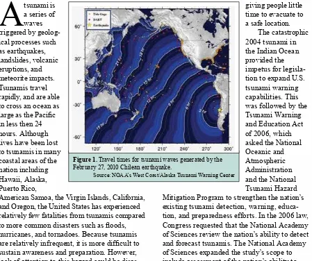
Figure 1. Travel times for tsunami waves generated by the February 27, 2010 Chilean earthquake.
example of the speed with which a tsunami triggered close to shore can strike. Even if coastal communities are prepared for the tsunami threat, there will likely be only minutes from the triggering event until the time that waves reach the shore—not enough time to disseminate warning messages and barely enough time for anyone to lee more than a short distance. Survival depends on the ability to recognize the natural cues of a tsunami—mainly the ground shaking from the tsunami-gener-ating earthquake—and know to
evacuate even without oficial warnings. Integrated public education and
preparedness planning is needed to make this knowledge commonplace.
Even as tsunami waves move farther away from their source, they can continue to wreak havoc. In the hours following the Indian Ocean earthquake, tsunami waves travelled out from the triggering quake, bringing death and destruction as far away as India and Somalia. The time it takes tsunamis to reach coastal locations farther away increase the chance that warnings and evacuation notices could be issued—but the accuracy and timing of these warnings are critical, as is ensuring that all individ-uals in the affected area receive the message and that the evacuations are well planned and managed. Because communities threatened by distant tsunamis will probably be too far from the triggering event to detect the natural signals of a tsunami, oficial messages are likely to be the only indicator that a tsunami is coming. Adequate public education is essential to ensure that people understand how to respond to warning messages.
Improving Tsunami Education in the
United States
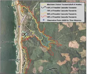
Providing tsunami education to the hundreds of thousands of residents, employees, and tourists in coastal communities is a challenge for the nation. The current availability and adequacy of tsunami education and outreach is dificult to assess because the true breadth of U.S. tsunami education efforts is not known. Furthermore, a lack of pre-and post-outreach evaluations and post-event assessments means no consistent baseline and no metrics exist by Figure 2. A probable tsunami hazard map for Cannon Beach, Oregon.
Source: Priest et al, 2009
Overall, the committee found that the nation’s tsunami efforts have improved since 2004. At the federal level, the National Oceanic and Atmospheric Admin istration has improved the ability to detect and forecast tsunamis by expanding a network of tsunami-detecting ocean sensors, known as DART (Deep-ocean Assessment and Reporting of
Tsunamis) buoys. Other federal and state activities include improving tsunami hazard and evacuation maps for many coastal communities, assessing vulnerability of some coastal populations in several states, and undertaking new efforts to increase public awareness and response when faced with a tsunami. Despite these advances, many coastal communities in the United States still face major challenges in responding to a tsunami generated close to shore, which could reach the coast less than an hour after the triggering event.
Tsunami Survival
which to gauge the effectiveness of education programs. The report concludes that outreach efforts could be improved by incorporating the latest social science research on hazard education and conducting routine evaluations of education programs.
Research in the social sciences can provide the insight needed to design more effective hazard education programs. For example, research has shown that training campaigns are more effective when tailored to the strengths and vulnerabilities of
speciic members of the community. A program designed for long-time residents could capitalize on their familiarity with the surroundings, empha-sizing household
preparation strategies and the importance of creating community networks. In contrast, a program designed for tourists could focus on easily identiiable land-marks, providing information via signs posted in prominent locations and training hotel staff, tour guides, life guards, and vendors to help tourists in the event of a tsunami.
Generating Tsunami Warnings
Oficial tsunami warning messages are produced and disseminated by the nation’s two Tsunami Warning Centers, located in Hawaii and Alaska. The Tsunami Warning Centers assess the potential for a tsunami by monitoring seismic activity and analyzing information from coastal sea level gauges and the DART open ocean sensors,
which detect changes in wave height. Based on analysis of these data, the centers issue alerts to the emergency managers in their respective areas of responsibility.
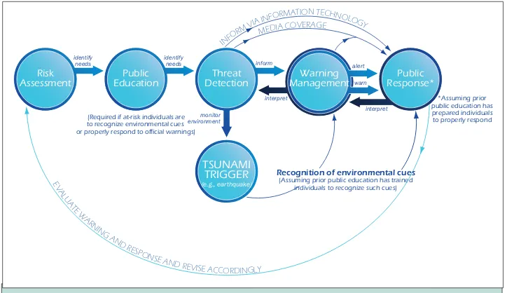
Although operational procedures for tsunami detection at the two centers are similar, the centers are managed by different regional ofices, use different technology, and have separate support and organizational cultures. Each center issues and disseminates tsunami warnings independently, Figure 4. The idealized tsunami program includes risk assessment, public education, threat
detection, and warning management, to elicit the appropraite public response to a tsunami.
identify
needs identifyneeds inform
monitor
Recognition of environmental cues (Assuming prior public education has trained
individuals to recognize such cues) Public Response* Warning
Management Risk
Assessment EducationPublic DetectionThreat
TSUNAMI TRIGGER (e.g., earthquake) (Required if at-risk individuals are
to recognize environmental cues or properly respond to official warnings)
*Assuming prior public education has prepared individuals to properly respond
Figure 3. North Paciic Ocean, showing predicted maximum wave heights (shown in color) and arrival times (indicated by contour lines with numbers representing hours after the triggering earthquake) of tsunami waves generated by a magnitude 8.3 earthquake near the Kuril Islands on November 15, 2006.
Committee on the Review of the Tsunami Warning and Forecast System and Overview of the Nation’s Tsunami Preparedness: John A. Orcutt (Chair), University of California, San Diego; Martha R. Grabowski (Vice-Chair), Le Moyne
College, Syracuse, New York and Rensselaer Polytechnic Institute, Troy, New York; Brian F. Atwater, U.S. Geological Survey;
Ann Bostrom, University of Washington, Seattle; George Crawford, Washington State Emergency Management Division (Ret.); Richard K. Eisner, Research Center for Disaster Reduction Systems, Disaster Prevention Research Institute, Kyoto University,
Japan; Jian Lin, Woods Hole Oceanographic Institution; Douglas S. Luther*, University of Hawaii, Manoa; Hugh B. Milburn,
National Oceanic and Atmospheric Administration (Ret.); Dennis S. Mileti, University of Colorado (Ret.); Emile A. Okal*,
Northwestern University; Costas E. Synolakis, University of Southern California, Los Angeles; Nathan J. Wood, U.S.
Geological Survey; Harry Yeh, Oregon State University; Claudia Mengelt (Study Director), National Research Council.
* resigned from committee
The National Academies appointed the above committee of experts to address the speciic task requested by Congress. The members volunteered their time for this activity; their report is peer-reviewed and the inal product signed off by both the committee members and the National Academies. This report brief was prepared by the National Research Council based on the committee’s report.
For more information, contact the Ocean Science Board at (202) 334-2714 or visit http://dels.nas.edu/osb. Copies of Tsunami Warning and Preparedness are available from the National Academies Press, 500 Fifth Street, NW, Washington, D.C. 20001; (800) 624-6242; www.nap.edu.
Permission granted to reproduce this brief in its entirety with no additions or alterations. Permission for images/igures must be obtained from their original source.
© 2010 The National Academy of Sciences
which has resulted in confusion in the past. Given the current organizational structure and the geographic delineation in areas of responsibilities, such confusion could occur again if the two centers continue to release distinct warning messages to the public. The report discusses possible solutions to these issues ranging from harmonizing message content to changing the organizational structure of the Tsunami Warning Centers, for example by merging the two centers.
Strengthening the Detection and Forecasting
Network
Information collected from the sea level sensors generates forecasts of tsunami wave heights which are used to adjust or cancel warnings, watches, and advisories. These data can also reveal tsunamis from sources that do not generate seismic waves, such as sea loor landslides. Since the passage of legislation to expand and strengthen the nation’s tsunami detection efforts, an array of 39 tsunami-detecting DART buoys have been manufactured
and deployed, 16 new coastal sea level gauges have been established, and the 33 existing water level stations have been upgraded. These efforts have closed signiicant gaps in the sea-level observation network. However, some fundamental issues remain concerning gaps in coverage, the value of indi-vidual components in the network, and the risk to the warning capability from failures of indi-vidual or groups of stations in the open ocean sensor network.
Conclusion
Minimizing future losses to the nation from tsunamis requires persistent progress across the broad spectrum of efforts the report reviews: risk assessment, public education, government coordina-tion, detection and forecasting, and warning-center operations. Sustained efforts in all these areas will be needed for communities to prepare for an event that may occur years to decades in the future but affords only minutes or hours for people to respond.