CHEMICAL COMPOSITION AND HYDRAULIC
CONNECTIVITY OF SPRINGS IN THE
SOUTHERN SLOPE OF MERAPI VOLCANO
Johnny Boulom∗1, Doni Prakasa Eka Putra2, and Wahyu Wilopo2
1Department of Civil and Environmental Engineering, National University of Laos 22Department of Geological Engineering, Faculty of Engineering, Gadjah Mada University
Abstract
Springs are easily found in the southern slope of Merapi volcano, Sleman Regency, Yogyakarta Spe-cial Province, Indonesia. Springs origins on this lo-cation are commonly related to the existing of Merapi Aquifer System, but importance question of all these springs are hydraulic connectivity among them. In response to the issue, the objective of this research is to determine hydraulic connectivity of springs based on their chemical composition. To answer the objec-tives, measurement of spring discharge and physico-chemical properties of spring’s water and sampling of selected spring’s water were conducted on this re-search in the study area. Water chemistry compo-sition was classify by Kurlov formula and displayed by Fingerprint diagram and Composition diagram. Results show that the chemical compositions of most all spring samples are almost similar and does not significantly different for most properties from up-stream to downup-stream, which are Na–Ca–HCO3 wa-ter, only one spring of Umbul Jatiningsih spring had different chemical composition of Ca–Na–Mg– HCO3water. Based on the Fingerprint diagram and Composition diagram evaluation, the spring’s wa-ter can be differentiated into three groups. Group 1 consists of ten springs which have similar chem-ical composition of Na–Ca–HCO3 and with electri-cal conductivity ranges between 150 to 200μS/cm.
Group 2 consists only one spring “Umbul Pajan-gan” which contain similar chemical composition to
∗Corresponding author: J. BOULOM, Department of Civil and Environmental Engineering, National Univer-sity of Laos. E-mail: [email protected]
Group 1 but has significantly higher ions concen-tration (EC value about 400 μS/cm) and Group 3
consists also only one spring “Umbul Jatiningsih” which has significantly different ionic composition with Group 1 and 2. Regarding on this condition, it can be concluded that Group 1 spring is hydrauli-cally connected and relate to the shallow aquifer sys-tem of Merapi Aquifer Syssys-tem. In other side, wa-ter of spring “Umbul Pajangan”possibly comes from deeper aquifer system of Merapi Aquifer System and this argument is supported by the spring discharge evaluation. Finally, spring “Umbul Jatiningsih” is originate mainly from different aquifer system of porous limestone aquifer.
Keywords: Merapi aquifer system, spring, chemi-cal composition, geologichemi-cal condition
1 Introduction
con-nected according to the conceptual section of MAS by MacDonald and Partners (1984).
Determination of aquifer hydraulic connec-tivity can be conducted by evaluation of the iso-topes and chemical composition of water (Ma-zor, 2004; Praamsmaet al. 2008; Jaiet al., 2013). Application of stable isotopes (δ18O and δ2H)
for understanding the hydraulic connectivity of some springs and wells in the southern slope of Merapi Volcano has also reported by Wijatnaet al. (2013). Based on the stable isotopes analysis, Wijatnaet al. (2003) concluded that the springs located on the elevation between 600 to 1200 masl of southern slope of Merapi do not have hydraulic connection with springs located on the elevation between 300 to 500 masl of south-ern slope of Merapi, although the source of wa-ter for the lower elevation spring comes from higher elevation. Results from Wijatna et al. (2013) is contradictive and opposite to the state-ment of MacDonald and Partners (1984), there-fore in response to this problem, this research paper attempt to determine the hydraulic con-nectivity of springs in the southern slope of Merapi based on its chemical composition and geological condition.
2 Location and geological setting
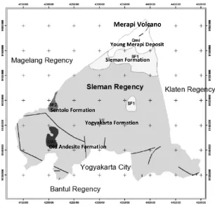
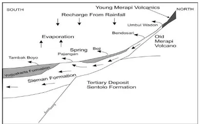
The study area is located in the southern slope of Merapi Volcano of Sleman regency (see Fig-ure 1). The study area can be differentiated into three zones of morphologies; Upper slope of Merapi Volcano, Middle slope of Merapi Vol-cano and Lower slope of Merapi VolVol-cano. Up-per slope zone located 900 meters above sea level (masl) and has slope of more than 50%. The middle slope zone has located between 900 masl elevation and 150 masl, it has average gra-dient slope less than 20%. The lower slope zone is bordered with elevation of about 150 masl, this area has slope less than 5% (MacDonald and Partners, 1984).
The geology of the study area are composed by tertiary rocks and quaternary succession of Merapi volcano (MacDonald and Partners, 1984). The tertiary rocks of old andesite for-mation and limestone sentolo forfor-mation occur on southwest and west of the study area (see
Figure 2). The quarternary succession can be differentiated into two groups; Old Merapi vol-canic formation and Young Merapi volvol-canic for-mation. The outcrop of old volcanic merapi distribute on the upper slope of Merapi Vol-cano (see Figure 2). The young merapi vol-canic deposits are largely attributable in the study area. This young merapi volcanic mation divided into two deposits; Sleman for-mation and Yogyakarta forfor-mation (MacDonald and Partners, 1984). Referring to MacDonald and Partners (1984), the Sleman Formation has been designed as the lower part of a major vol-caniclastic unit which was formerly include in the Younger Merapi Volcanics. In the north, on the Merapi Upper Slopes, it consists of sands and gravels with interspersed boulders, all de-rived from volcanic ejector. The Yogyakarta For-mation forms the surface outcrop from the Mer-api Middle Slopes of the study area. It consti-tutes the upper part of the former Younger Mer-api Volcanics. The formation consists of an in-terbedded sequence of sands, gravels, silts and clays.
Figure 1: Location of the study area and morphology zones in the study area (modified from Mac-Donald and Partners, 1984).
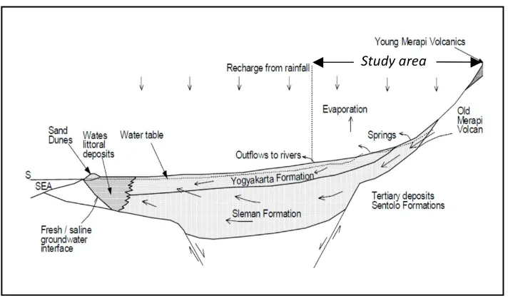
Figure 3: Conceptual model of Merapi Aquifer System from Merapi Volcano to the Indian Ocean (Modified from MacDonald and Partners, 1984).
3 Theoretical Background
The major ionic species in groundwater are Na+ a dissolved representation of the aquifer lithol-ogy, chemical process and also can be used to determine the hydraulic connectivity, especially ion which are conservative like Cl− (Mazor, 2004).
Kurlov formula is a very useful method for primary characterization of the chemical com-position of water (Zaporozec, 1972). On this method, chemical composition is expressed by a quasifraction with major anions and cations in the numerator and denominator, respectively. In designating the water type, only those con-stituents are considered which amount to more than 25% of the total meq/l. The Kurlov for-mula can be used for basic characterization of water composition in table or on maps. It is useful for general classification and as a basis for graphical methods and further interpreta-tion (Zaporozec, 1972).
Figure 4 is a fingerprint diagram of the groundwater chemical composition data. In this figure each spring water is represent by one line that provides a visual description of the relative abundance pattern of the dissolved ions (the shape of each line) and the relative
Figure 4: Fingerprint diagram (Mazor, 2004).
salinity (the position of the line at the upper or lower part of the diagram). Each line is the compositional imprint of a water sample and similar pattern means a relatively similar water type and sources (Mazor, 2004).
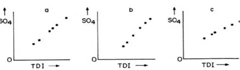
pat-terns seen in composition diagrams; a cluster (Figure 5), two clusters (Figure 6), triangular distribution (Figure 7) and random distribution (Figure 8).
4 Methodology
In order to answer the objectives, detailed field investigation was conducted for twelve springs in the study area from September, 2013 to May, 2014. The location of observed springs is shown in Figure 8. Eleven springs were emerging from volcanoclastics deposits and only one spring which is Jatiningsih spring emerges from lime-stone aquifer. During the field investigation, physico-chemical properties of water such as water temperature, pH, electric conductivity (EC) was measured including the springs dis-charge for every month. Moreover, samplings of lithology were also conducted for XRD anal-ysis.
Secondary rainfall data in the study area is also collected to be used for evaluating the re-lation between spring discharge and changes of chemical composition of water. Springs wa-ter samplings were conducted twice during the field inverstigation period in the dry and wet season. The springs water was analysed for ma-jor ions such as Na+ ated based on the method of Kurlov formula for their water type classification. For under-standing springs hydraulic connectivity in the study area, evaluation of chemical composition and fingerprint diagram were applied.
5 Results and discussion
Applying Kurlov formula for the dry and wet season data of spring water, the majority water type of spring in the southern slope of Merapi Volcano is classified as Na–Ca–HCO3 water,
and only Jatiningsih spring falling on Ca– Na–Mg–HCO3 water type. These water type
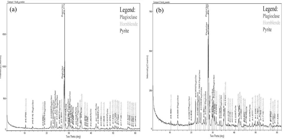
matches with the aquifer lithology (see Table 1 and 2). Result of XRD of the volcanoclastics deposits of Young Merapi deposits, Sleman for-mation and Yogyakarta forfor-mation (see Figure 9) show that these deposits are rich on plagio-clase feldspar (NaAlSi3O8to CaAl2Si2O8),
horn-blende ((Ca,Na)2(Mg,Fe,Al)5(Al,Si)8O22(OH)2)
and pyrite (FeS2). Due to high content of
pla-gioclase and hornblende, groundwater on the volcaniclastic deposits of Merapi rich on Na+ and Ca2+
mg/L. For Jatiningsih spring wa-ter, it is normal if calcium ion become the major cation than sodium because this spring emerges from limestone which commonly will rich on calcite (CaCO3) to dolomite (CaMg(CO3)2).
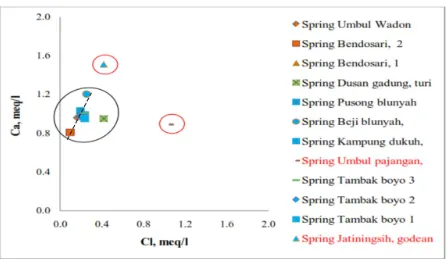
Plotting the chemical data on fingerprint dia-gram shows the spring water in the study area can be grouped into several groups. Figure 10 shows clearly the three group of spring water in the study area, in which three distinctive line pattern are recognized, which are orange and blue line representing water from spring Um-bul Wadon, Bendosari 1, Bendosari 2, Dusan Gadung, Pusong, Beji, Duku, Tambakboyo 1, Tambakboyo 2, and Tambakboyo 3, dark blue line shows line pattern of water from spring “Pajangan” , and red line is water from spring “Jatiningsih”. Group 1 consists of ten springs which have similar chemical composition of Na–Ca–HCO3 and with electrical conductivity
ranges between 150 to 200 μS/cm. Group 2 consists only one spring “Pajangan” which con-tain similar chemical composition to Group 1 but has significantly higher ions concentration (EC value about 400μS/cm) and Group 3 con-sists also only one spring “Jatiningsih” which has significantly different dominant ionic com-position with Group 1 and Group 2. More-over, composition diagram of the chemical data also shows three distinct compositional water groups emerge (see Figure 11). Based on Figure 11, it can be concluded that: 1) there are three clusters of water which may representing differ-ence aquifer system or source of water; 2) Pajan-gan spring water is fed by a water that has rel-atively higher Cl concentrations than the other springs; 3) Jatiningsih spring is fed by a water has relatively higher Ca concentration than the other springs; 4) there is possibility of intermix-ing water process on group 1 between water in aquifer and rainwater.
shal-Figure 5: A cluster pattern in a set of composition diagrams of five adjacent springs. The pattern indicates one type of water is involved. The more parameters that are checked, the higher is the confidence of the conclusion (Mazor, 2004).
Figure 6: Two clusters in a set of eight adjacent springs. The pattern indicates two distinct types of water occur in the studied region (with no intermixing): a water type of low Cl, Mg, and Na and an elevated temperature, and a water type of high Cl, Mg, and Na and a low temperature (Mazor, 2004).
Figure 7: These are mixing lines, of which three variations are shown: (a) the line extrapolates to the zero points, indicating mixing of a saline water with a water that has neglegible SO4concentrations
(dilution); (b) the line extrapolates to a point in the TDI axis, indicating the fresher end member contains significant concentrations of ions other than SO4; and (c) the line extrapolates to the SO4
Figure 8: Location of the observed springs in the study area.
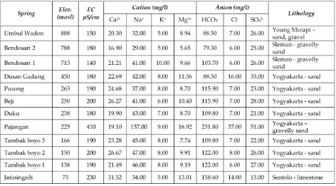
Table 2: Chemical composition of observed spring water in the study area collected at May 2014
Figure 10: Fingerprint diagram of spring water chemical data in the study area.
low aquifer system of MAS which affected by local rainwater recharge, deeper aquifer system of MAS and porous limestone aquifer of Sen-tolo formation. In order to prove this condi-tion, comparison of rainfall data to the spring discharge is conducted for springs group 1 and group 2. Figure 12 shows clearly how the spring discharge of Umbul Wadon spring (group 1) fol-lowing the trend of rainfall data, but this rela-tion can not be seen for Pajangan spring (group 2) and this fact strongly support the argument that this water spring originate from deeper aquifer system of MAS. According to the result of this research a conceptual scheme of spring system in the southern slope of Merapi Volcano can be made and shown in Figure 13.
6 Conclusion
Based on the fact found in the discussion above, there are some conclusions relate to this re-search can be taken, i.e.: 1) The majority wa-ter type of spring in the southern slope of Mer-api Volcano is classified as Na–Ca–HCO3
wa-ter; 2) The water group in the study area can be classified into three distinct groups, in which group 1 consists of ten springs which have similar chemical composition of Na–Ca–HCO3
and with electrical conductivity ranges between 150 to 200 μS/cm, group 2 consists only one spring “Pajangan” which contain similar chemi-cal composition to group 1 but has significantly higher ions concentration (EC value about 400 μS/cm) and group 3 consists also only one spring “Jatiningsih” which has significantly dif-ferent dominant ionic composition with group 1 and group 2; 3) Group 1 spring is hydrauli-cally connected and relate to the shallow aquifer system of Merapi Aquifer System and affected by local rainwater, another side, water of spring “Umbul Pajangan” comes from deeper aquifer system of Merapi Aquifer System. However, it is presumably that water from Pajangan spring comes also from higher elevation in the slope of Merapi Volcano; 4) Finally, spring “Jatiningsih”
is originate mainly from different aquifer sys-tem of porous limestone aquifer and does not hydraulically connection with group 1 and 2.
References
Jai, M.P., Inayathulla, M., and Shahul H.A. (2013) Hydraulic Continuity between Groundwater Sources in the Proximity of Jakkur Lake of Bangalore – Evidence from Ion Chemistry, Journal of Engineering and Technology, Vol.2, Issue 3, p.128-135, Re-search and Reviews.
MacDonald and Partners (1984) Greater Yo-gyakarta Groundwater Resources Study Vol-ume 3: Groundwater, 116 p, Directorate Gen-eral of Water Resources Development Project (P2AT), Ministry of Public Works, Govern-ment of The Republic of Indonesia.
Mazor, E. (2004) Chemical and Isotopic Ground-water Hydrology, 3rd edition, 453 p, Marcel Dekker Inc.
Praamsma, T., Novakowski, K., Kyser, K., and Hall, K. (2009), Using Stable Isotopes and Hy-draulic Head Data to Investigate Groundwa-ter Recharge and Discharge in Fractured Rock Aquifer, Journal of Hydrology, Vol.366, p.35-45, Elsevier.
Putra, D.P.E. (2003) Integrated Water Resources Management in Merapi – Yogyakarta Basin, ASEAN University Network/South East Asia Engineering Education Development Network (AUNSEED-NET), Yogyakarta (Un-published Report).
Wijatna, A.B., Sudarmadji, Sunarno, and Hen-drayana, H. (2013) Tracing The Origin of Spring Water by Using Environmental Iso-topes in the Southern Slope of Mount Merapi, Indonesia, Asean Engineering Journal Part C, Vol.2 No.2, p.118-130, ASEAN University Network/Southeast Asia Engineering Educa-tion Development Network.
Figure 12: Comparison between monthly rainfall data in the study area with discharge of (a) Umbul Wadon spring discharge and (b) Pajangan spring discharge.