*
Xu AigongProfessor in Liaoning Technical University. His research interests major in the integration of GNSS, GIS and ITS and
INTERVAL TYPE-2 FUZZY BASED NEURAL NETWORK FOR HIGH RESOLUTION
REMOTE SENSING IMAGE SEGMENTATION
Wang Chunyan
1Xu Aigong
2Li Chao
3Zhao Xuemei
21. School of Mining Industry and Technology, Liaoning Technical University Huludao 125105; 2. School of Geomatics, Liaoning Technical University, Fuxin 123000; 3 Yunnan Technology Center of Basic Surveying and Mapping, Yunnan 650034
China – ([email protected]; china [email protected];[email protected];[email protected])
CommissionVII, WG VII/4
KEY WORDS: Interval Type-2 Fuzzy Model, High Resolution Remote Sensing Image, Footprint of Uncertainty, Image
Segmentation, Neuron Networks
ABSTRACT:
Recently, high resolution remote sensing image segmentation is a hot issue in image processing procedures. However, it is a difficult task. The difficulties derive from the uncertainties of pixel segmentation and decision-making model. To this end, we take spatial relationship into consideration when constructing the interval type-2 fuzzy neural networks for high resolution remote sensing image segmentation. First, the proposed algorithm constructs a Gaussian model as a type-1 fuzzy model to describe the uncertainty contained in the image. Second, the interval type-2 fuzzy model is obtained by blurring the mean and variance in type-1 model. The proposed interval type-2 model can strengthen the expression of uncertainty and simultaneously decrease the uncertainty in the decision model. Then the fuzzy membership function itself and its upper and lower fuzzy membership functions of the training samples are used as the input of the neuron network which acts as the decision model in the proposed algorithm. Finally, the relationship of neighbour pixels is taken into consideration and the fuzzy membership functions of the detected pixel and its neighbourhood are used to decide the class of each pixel to get the final segmentation result. The proposed algorithm, FCM and HMRF-FCM algorithm and an interval type-2 fuzzy neuron networks without spatial relationships are performed on synthetic and real high resolution remote sensing images. The qualitative and quantitative analyses demonstrate the efficient of the proposed algorithm, especially for homogeneous regions which contains a great difference in its gray level (for example forest).
1. INTRODUCTION
Image segmentation is an important task in remote sensing image processing. High-resolution remote sensing data can present more clearly detail information of ground objects, which greatly eliminates the uncertainty of pixel feature caused by mixed pixel and has great potential and advantages in accurate segmentation of ground objects. However, high resolution also brings some new problems and difficulties for remote sensing image segmentation. For example, (1) in more accurate spatial scale, the variability of pixel spectrum measure within a ground object in remote sensing image increases. As a consequence, ground objects with the same type will present more heterogeneity and spatial fragmentation (e.g., the asymmetric and multimodal distributions of the same ground object)(Bruzzone and Carlin., 2006); the similarity enhancement of different ground objects (e.g., the increase of overlapping region of the pixel spectrum measure distribution curves of different ground objects) can increase the uncertainty of pixel generic attribute; (2) Because the detailed ground information covered by high-resolution remote sensing image is rich, the complexity and diversify of ground objects and the lack of real ground coverage information further increase the uncertainty of segmentation decision-making. The above two uncertainties bring new problems and difficulties for the segmentation of high-resolution remote sensing image. At present, the fuzzy clustering method is one of the most commonly used and effective methods to solve the problem
of uncertain data clustering. The Fuzzy C-Means (FCM) (Bezdek., 1981) algorithm, incorporated with the correlation of pixels, is the most widely used method for its capacity to effectively deal with the pixel spatial correlation and fully describe the fuzziness and uncertainty of spectral measure in the image and other excellent features. The algorithm uses membership function to represent the pixel uncertainty, build the object function by defining the non-similarity measure, define the deterministic function model neighborhood relationship of the neighborhood pixel spectrum measure (Cai et al., 2007; Ahmed et al., 2002) or build the correlation model (Chatzisand and Varvarigon., 2008; Liu. et al., 2007) of the neighborhood pixels by Markov Random Field (MRF), and obtain the optimum fuzzy segmentation by solving the object function. Although these algorithms can smooth noise to a certain extent, effectively solve the problem of pixel uncertainty caused by the spatial correlation of pixels, and thus improve the segmentation accuracy of the algorithms, they cannot deal with the influence of uncertainty of decision-making on the segmentation results in high-resolution image segmentation.
the primary membership, and the definition of the secondary Tsao., 2008; Lin et al., 2014; Ahmadieh et al., 2011)with the information provided by the interval type-2 fuzzy model is the most commonly used method with the theory modeling decision-making model, which connect all the information provided by the interval type-2 fuzzy model in the form of weighted sum, determine whether the information play a role in the objective function with the weight symbol (positive weight means the membership function is activated, negative and zero weight means the membership function is restrained), and judge the importance of the weight with the value of weight (the greater the weight is, the more important its role will be). Compared with the traditional modeling method, this modeling method can greatly improve the quality of decision-making model. But the above segmentation method doesn't consider
that the influence of spatial correlation of pixels on segmentation accuracy. Thus, it is sensitive to noise.
To this end, this paper proposes a high-resolution remote sensing image supervised segmentation method based on interval type-2 fuzzy and neural network integrated with spatial relationship. First of all, in order to strengthen the generic uncertainty representation and increase the segmentation decision-making information, the membership function model with supervised sampling is built to process the pixel generic uncertainty in high-resolution image, and then the interval type-2 fuzzy model by fuzzing the mean or standard deviation in the type-1 fuzzy model is built. Then the fuzzy neural network model is built by taking the original membership and upper and lower membership of the training sample in all types as input. And finally implement the segmentation decision-making by integrating the spatial relationship.
2. DESCRIPTION OF THE PROPOSED ALGORITHM
2.1 Fuzzy image model
(1) Type-1 fuzzy image model
For the given image Z = {zj, j = 1,..., n}, where j is the index
representative general distribution model with good calculated performance, is used as the membership function model of the image (Type-1 fuzzy image model),
deviation of the ith type, respectively. (2) Interval type-2 fuzzy model
In order to improve the representation of generic uncertainty by type-1 fuzzy membership function and increase the accuracy of classification decision, fuzzing the mean and standard deviation in the type-1 fuzzy model, discreting the value in the interval [- 3σ, + 3σ] (the confidence of real membership function in the interval [ - 3σ, + 3σ] is 99.7%) is conducted within the interval [ - 3σ, + 3σ], and assume that the probability of occurrence of the various membership functions in the interval is the same. The interval type-2 fuzzy model with uncertain mean and standard deviation is built according to the following formula,
i
; when the mean remains the same, that is, if i1=i–, uji = uji+; if i1=i+, uji = uji-.
The upper membership and lower membership of the interval type-2 fuzzy model with uncertain mean are calculated as
The upper membership and lower membership of the interval type-2 fuzzy model with uncertain standard deviation are calculated as follows:
2.2 Segmentation decision-making model
The three-tier fuzzy liner neural network model is built with all the membership information of the original sampling set in the gray measure space (including the original membership, upper membership and lower membership). This neural network model adopts the supervised learning method to realize the determination of network parameter. The input vector is the set of the gray level g (g=0, 1…, 255) within the gray level range, and the expected output is the set of frequency values of the gray levels within the gray level range y = {ygi, g=0, 1, .., 255, i=1, .., m}; the number of
hidden-layer nodes is three times of the number of types; the output-layer nodes is the same with the number of types. The output function adopts the piecewise linear function, as shown below(Fig 1).
The membership of the gray levels in all types of UMF and LMF as well as the membership in the original membership function (membership function in homogeneous region) are calculated and the feature vector is formed as follows:
255
where Tg denotes the 3m dimension feature vector composed
of the membership of gray level g in all types. The above feature vector of all pixels in the gray measure range is taken as the out put. Then the following fuzzy linear neural satisfies the constraint condition that
1
activation function of output notes, which is piecewise linear function and meet the following conditions,
where max (yi) is the maximum histogram frequency value in
the ith type. This paper takes the histogram frequency values of the different types of training data as the expected output, and vgi is the actual output. The above neural network model
is built by estimating various types of weights and offsets with the least square method, and the membership matrix obtained is as follows,
m relationship with the upper membership and lower
membership of the type-1 fuzzy membership and type-2 fuzzy membership function, but also with the membership of the neighborhood pixels to the ith type. The larger the membership of the neighborhood pixels belong to the ith type is, the higher membership of the jth pixel belongs to the ith type will be. The segmentation decision-making model integrated with spatial relationship is built based on the above principle,
where fji represents the segmentation decision-making membership of the jth pixel to the ith type, Nj is the pixel
membership set in the 33 window with the pixel j as the center, #Ni = 9 is the number of the pixels in the window, k=1,
2 ,.., 9 is the index of neighborhood pixels.
The segmentation decision-making membership matrix is as follows: membership principle is used to realize the regional division of the image,
3. EXPERIMENTAL RESULTS AND DISCUSSION
To illustrate the feasibility and effectiveness, segmentation experiments are respectively tested on the synthetic high-resolution remote sensing images and the real high-resolution remote sensing images, and the quantitative and qualitative evaluations are made.
3.1 Synthetic high-resolution remote sensing image
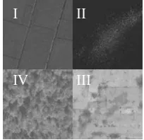
Fig. 2 shows four ground objects clipped from the real World View-II panchromatic image. The resolution is 0.5m, and the pixel size is 256256. I - IV region respectively represent cropland, partially frozen water area, concrete pavement, and forest.
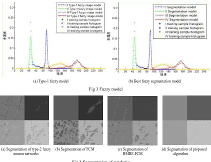
Fig. 3 (a) is the type-1 fuzzy model obtained by supervised sampling to each region and the histogram matching with the least square method, namely, Gaussian function model ; Fig. 3 (b) shows the best fuzzy segmentation model obtained by applying the method proposed in this paper and without considering the neighborhood relationship. The four curves with different colors stand for the histogram matching models of the four kinds of ground objects,and the symbols “”, “+”,
“☆” and “△” respectively denote the training sample
frequency values of the four regions.
Fig 4 shows the segmentation results of synthetic images Fig 1 Fuzzy linear neural network model
Fig 2 World view-2 synthetic images
I
II
obtained by different methods: In Fig. (a), the segmentation results of type-2 fuzzy neuron networks without considering the spatial relationship; In Fig. 4 (b) the standard FCM segmentation result; In Fi
g. 4
(c) the FCM segmentation result of Hidden Markov Random Field (HMRF) (HMRF-FCM); In Fig. 4 (d) the segmentation result by the method integrated with spatial relationship proposed in this paper.In order to evaluate the accuracy of the above different segmentation results, the confusion matrixes with the segmentation results in Fig. 3 (a)–(d) are obtained based on the standard templates shown in Fig. 1, and the product precision, user precision, overall precision and kappa coefficient are respectively calculated and listed in Table 1
Methods Precision indexes Homogeneous regions
I II III IV
Interval type-2 fuzzy neural network
User precision 0.972 0.992 0.980 0.884
Product precision 0.979 0.990 0.884 0.966
Overall precision =0.955; kappa = 0.940
FCM
User precision 0.770 0.999 0.986 0.789
Product precision 0.998 0.945 0.799 0.747
Overall precision =0.872; kappa = 0.830
HMRF-FCM
User precision 0.977 0.993 0.986 0.871
Product precision 0.966 0.992 0.882 0.972
Overall precision =0.953; kappa =0.937
Algorithms in this paper
User precision 0.994 0.995 0.997 0.991
Product precision 0.997 0.997 0.990 0.994
Overall precision =0.994; kappa =0.992 Table 1 Comparison of precision and kappa value
(1) In Fig. 2, in order to reflect the detail features of
high-resolution remote sensing image and the
complexity of the distribution features of the
homogeneous regions, the synthetic high-resolution
remote sensing image, involving four typical ground
objects: the partially frozen water area, the concrete
(b) Best fuzzy segmentation model (a) Type-1 fuzzy model
Fig 3 Fuzzy model
Fig.4 Segmentation of synthetic
(a) Segmentation of type-2 fuzzy neuron networks
(d) Segmentation of proposed algorithm
pavement with different shades, the forest with big
gray feature difference, and cropland, is tested using
the proposed approach. The frequency value
distribution of the training samples in different regions
(shown in Fig. 2) shows that, the distribution features
of the other three ground objects are all complex,
except that the cropland conforms to the Gaussian
distribution feature. The fitting effects of type-1 fuzzy
image model on the four different regions (Fig 2. (a))
are bad except for the cropland; but the proposed
method can highly fit the above four kinds of ground
objects (Fig. 2 (b)).
(2) In Fig 4, because the FCM algorithm can only deal
with medium-low resolution images and is sensitive to
noise, the cropland segmentation result (Fig. 4 (b)) of
FCM algorithm is better than the one of HMFR-FCM
(Fig. 4 (c)), large amount of pixels of the IV ground
object Forest are misclassified into the cropland, and
there are many misclassified pixels existing in the III
ground object due to large color difference. Compared
with the other three methods, the segmentation
accuracy of the standard FCM method is the lowest;
HMRF-FCM algorithm (Fig. 4 (c)) takes the
correlation of neighborhood pixel into consideration,
so it can overcome the noise effect and the
segmentation result of the four ground objects are
better than the standard FCM algorithm result. But it
doesn’t take the segmentation decision
-making
influence into consideration and cannot deal with the
clustered noise, such as the dark area of the cement
road. Thus, its segmentation result is slightly lower
than that of interval type-2 fuzzy neural network (Fig.
4 (a)); Fig 3 (a) shows that the segmentation model
based on the interval type-2 fuzzy neural network can
match
the
complex
training
data
histogram
distribution characteristics of high-resolution remote
sensing image to greatly improve the segmentation
accuracy. But it is sensitive to noise and there is large
number of salt and pepper noise in the segmentation
result; to overcome of disadvantages of the
segmentation model based on interval type-2 fuzzy
neural network, the proposed method has integrated
the spatial relationship into the membership spatial
domain, effectively solving the above problems.
Therefore, its segmentation result is the best with a
little sparse noise.
(3) Table 1 lists that the segmentation model based on
interval type-2 fuzzy neural network adopts the
supervised sampling. The segmentation model in this
paper can match the training data histogram in high
accuracy, with its overall precision 0.955, and kappa
value 0.940. But the precision of the HMRF-FCM
segmentation method (overall precision is 0.953 and
the kappa value is 0.937) is slightly lower than that of
the method based on interval type-2 fuzzy neural
network; for the segmentation of the above four
ground objects, the lowest segmentation precision of
the standard FCM method is 0.789, the method based
on interval type-2 fuzzy neural network is 0.884, and
the HMRF-FCM is 0.871; while the lowest precision
of the method proposed in this paper is 0.99, and both
its overall precision and kappa value have been more
than 0.99, which has realized high-precision
segmentation of high-resolution synthetic image.
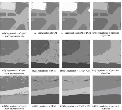
3.2 Real high-resolution remote sensing image
Fig. 5 (a) shows a World View-2 panchromatic image
with the resolution of 0.5m. The colors from light to
heavy respectively represents the house, road and
lawn in order; Fig. 5 (b) and (c) show the 0.6m
resolution QuickBird panchromatic images. In Fig. (b),
the colors from light to heavy respectively stands for
road, forest and water area in order. Fig. 5 (c) shows
the limestone, granite and water area, and their image
sizes are all 256
256.
the segmentation of limestone and granite, the
method proposed in this paper is the best,
HMRF-FCM is better than the method based on
interval type-2 fuzzy neural network, and the
standard FCM is the worst. The segmentation
results of the above real high-resolution remote
sensing images show that, compared with the other
three methods, the proposed method can improve
the precision.
4. CONCLUSION
In this paper, puts forward a supervised segmentation
method of high-resolution remote sensing image
based on the interval type-2 fuzzy neural network is
proposed. This method can deals with the pixel
generic uncertainty by building the type-1 fuzzy
image model; and the interval type-2 fuzzy model is
built to describes the uncertainty of segmentation
decision-making by building the interval type-2 fuzzy
model; then take s the primary membership as well as
the upper and lower membership of each pixel by
supervised sampling in all types as the input to build
the fuzzy linear neural network model; and finally
(a) World View-II image (b) QuickBird image (c) QuickBird image
Fig 5 High resolution remote sensing image
Fig.6 Segmentation of image
(b1) Segmentation of type-2 fuzzy neuron networks
(c1) Segmentation of type-2 fuzzy neuron networks
(b2) Segmentation of FCM
(c2) Segmentation of FCM
(b3) Segmentation of HMRF-FCM
(c3) Segmentation of HMRF-FCM
(b4) Segmentation of proposed algorithm
(c4) Segmentation of proposed algorithm
(a1) Segmentation of type-2 fuzzy neuron networks
realizes fuzzy classification by building neighborhood
relationship in the membership domain is built to
realize fuzzy classification. In order to verify the
feasibility and validity of the algorithm proposed
algorithm min this paper, the interval type-2 fuzzy
neural network method which does not integrate the
spatial relationship, the standard FCM algorithm,
HMRF-FCM which integrates spatial relationship, and
the proposed method proposed in this paper are
respectively applied to tested on conduct the
segmentation tests on the of high-resolution synthetic
images and real images. The quantitative and
qualitative analysis results verifyies that the proposed
method proposed in this paper can improve the
segmentation precision. Although this method can
restrain the noise impact in the area and realize better
segmentation to the high-resolution remote sensing
image, it has the fuzzy boundary phenomenon.
Therefore, the researches are focus on the above
problems to further improve the algorithm in the
further.
ACKNOWLEDGMENTS
T
his work was supported by Research Fund for the
Doctoral Program of Higher Education of China (No.
20122121110007)and
National
Natural
Science
Foundation of China (No. 41271435; No. 41301479).
REFERENCE
Ahmed, M. Yamany, S. Mohamed, N. Faragand, A. Moriarty, T., 2002. A modified fuzzy c-means algorithm for bias field estimation and segmentation of MRI data. IEEE Transactions On Medical Imaging, 21(3), pp. 193-199.
Ahmadieh, K. M. Erdal, K. Mojmmad, T. et al., 2011. Analysis of the noise reduction property of type-2 fuzzy logic systems using a novel type-2 membership function. IEEE Transactions on Systems Man and Cybernetics Part B Cybernetics, 41(5), pp. 1395-1406.
Bezdek, J., 1981. Pattern recognition with fuzzy objective function algorithms. New York: Plenum, pp. 79-88.
Bruzzone, L. and Carlin, L., 2006. A multilevel context-based system for classification of very high spatial resolution images. IEEE Transactions on Geoscience and Remote Sensing, 44(9), pp. 2587-2600.
Castillo, O. Melin, P., 2004. Adaptive noise cancellation using
type-2 fuzzy logic and neural networks. Proceedings of the 2004 IEEE International Conference on Fuzzy Systems, 2(7), pp. 1093–1098.
Cai, W. Chen, S. Zhang, D., 2007. Fast and robust fuzzy c-means clustering algorithms incorporating local information for image segmentation. Pattern Recognition, 40(3), pp. 825-838.
Chatzisand, S. P. and Varvarigon, T. A., 2008. A fuzzy clustering approach toward hidden Markov random field models for enhanced spa1109tially constrained image segmentation. IEEE Transactions on Fuzzy System, 16(5), pp. 1351-1361.
Jonr, I. Innocent, P. R. Bames, M. R., 2000. Neuro-fuzzy clustering of radiographic tibia image data using type-2 Fuzzy Sets. Information Sciences, 125(1-4), pp. 65-82.
Juang, C. F. Tsao, Y. W., 2008 A type-2 self-organizing neural fuzzy system and its FPGA implementation. IEEE Transactions on Systems Man and Cybernetics Part B Cybernetics A Publication of the IEEE Systems Man and Cybernetics Society, 38(6), pp. 1537-48.
Karnik, N. N. Mendel, J. M. Liang Q., 1999. Type-2 fuzzy logic systems [J]. IEEE Transactions on Fuzzy Systems, 7(6), pp. 643–658.
Karnik, N. N. Mendel, J. M., 2001. Centroid of a type-2 fuzzy Set. Information Sciences, 132(1), pp. 195-220.
Liang, Q. Mendel, J. M., 2001. Mpeg VBR video traffic modeling and classification using fuzzy technique [J]. IEEE Trans on Fuzzy Systems, 9(1), pp. 183–193.
Liu, S. Y. Li, X. F. Li, H. G. Li, Z. M., 2007. Research of fast image segmentation based on Markov spatial constrain and fuzzy c-means clustering. Application Research of Computers, 24(8), pp. 220-223.
Lin, Y. Y. Liao, S. H. Lin, C. Y., 2014. Simplified interval type-2 fuzzy neural networks. IEEE Transactions on Neural Networks and Learning Systems, 25(5), pp.959-969.
Mendel, J. M., 2000. Uncertain rule-based fuzzy logic systems: Introduction and New Directions. Prentice Hall PTR.
Melin, P. Solano, D. Soto, M. et al., 2006. Voice recognition with neural networks, type-2 fuzzy logic and genetic algorithms. Journal of Engineering Letters, 13(2), pp. 08–116.