Agrometeorological aspects of agriculture in the sub-humid
and humid zones of Africa and Asia
Shrikant S. Jagtap
a,∗, Ah Kee Chan
baInstitute of Food and Agricultural Sciences, University of Florida, Gainesville, Florida, FL 32611-0570, USA bMalaysian Meteorological Service, 46200 Petaling Jaya Selangor DE, Malaysia
Abstract
Entire sub-Saharan Africa and pockets of Asian population is at risk of starvation. The problems and possibilities are however quite different amongst the two regions. Africa with its less than 8% of land irrigated, 3% or more population growth rate, continues to practice only rudimentary, nonscientific form of agriculture. In Asia where input use is high, farmers are approaching economically optimum yield levels, making it difficult to sustain the same rate of yield gains. While efforts to improve long-term productivity on small scale farm must be accelerated, more emphasis must also be placed on research that will help farmers and governments better cope with expected increases in risks resulting from climatic fluctuations, use of limited water resources, poor market integration and other problems. Finally we believe that all appropriate scientific tools including advanced weather forecasting, information technologies such as models, decisions tools should be mobilized to help solve the problems facing small-scale farmers in developing countries. Due to lack of financial support, the network of meteorological stations do not adequately cover various agrometeorological zones to meet user needs. The general lack of confidence in the reliability of weather forecasts has caused farmers not trust and use the weather forecasts. Training opportunities for meteorological services staff in the use of modern tools like computer simulation modeling, remote sensing, geographic information systems as well as electronic instrumentation is needed. © 2000 Elsevier Science B.V. All rights reserved.
Keywords: Agriculture; Climate; Food security; Early warning; Needs; Opportunities
1. Ecological and economic setting
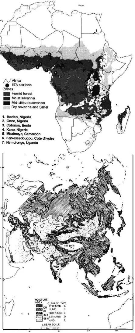
Africa and Asia each consist of four major agroe-cologies (Fig. 1). They are the arid and semi-arid zone, the subsumed or moist savanna zone and the humid zone. Most economies and peoples depend on semi-subsistence agriculture. Farming practices have developed as a response to environmental dictates, especially agroclimatic factors, type and intensity of
∗Corresponding author. Tel.:+1-352-392-7719; fax:+1-352-392-4092.
E-mail address: [email protected] (S.S. Jagtap)
production, and human interventions aimed at spread-ing risks through diversification of resource use. The movement of inter tropical convergence zone dominates African climatology, while most of Asia generally comes under the influence of monsoon. Depending on their intensity and the location, floods or droughts can occur. These areas are also affected by El-Nino/La-Nina events. These events could ei-ther enhance or reduce precipitation significantly. The fluctuations of rainfall are therefore a common characteristic of the areas. Since irrigation is either not practised at all or in primitive form, most farm-ers are unusually vulnerable to economic impacts of
Fig. 1. The arid, sub-humid and humid zones of Africa and Asia.
climatic fluctuations. These problems may become more severe in the fragile ecosystems of Sub-Saharan Africa (SSA) if changes in the global climate occur as projected by the world’s leading atmospheric and oceanic scientists (IPCC, 1990).
highlands, for example, there is little or no opportu-nity to fallow lands. Also, as agriculture is progres-sively transformed from the traditional, extensive fal-low systems to continuous cropping, yields of crops and land productivity decline and sustainability is threatened. Intensification can be accelerated through research, which could consider socio-economic, nat-ural resource, technical and institutional factors that influence productivity and sustainability. Ecological and economic sustainability can be achieved when the natural resources of land, crops, animals and wa-ter are used to reinforce each other. However, holistic research on production systems in the region is weak partly due to lack of base line data, suitable method-ology to measure benefits, shortages of qualified personnel, and institutional infrastructure.
2. Africa
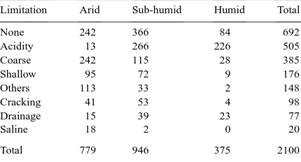
The 3140 million ha land mass of Africa consists of four major agroecologies (Fig. 1). The deserts (1017 million ha), the arid and semi-arid zone (30–150 days growing season, 787 million ha), the sub-humid zone (151–270 days growing season, 957 million ha) and the humid zone (271–365 days growing period and oc-cupies 379 million ha). Major soil related constraints to crop production are varied ranging from acidity, salinity and heavy cracking to coarse texture (Table 1). The sub-humid zone is mostly endowed with ma-jor constraint-free soils and the humid zone. Acidity is the major constraint in both the humid and sub-humid
Table 1
Major soil related constraints to crop production by agroecological zones in Sub-Saharan Africaa
Limitation Arid Sub-humid Humid Total
None 242 366 84 692
Acidity 13 266 226 505
Coarse 242 115 28 385
Shallow 95 72 9 176
Others 113 33 2 148
Cracking 41 53 4 98
Drainage 15 39 23 77
Saline 18 2 0 20
Total 779 946 375 2100
aAll areas in million ha.
zone, while coarse textured soils is the major problem of the arid zone. It is not known to what extent cul-tivation prevails on each of these soils. There is also greater disparity in population amongst the zones. Of the total present population in SSA, more than 43% live in West Africa. Thus, the aggregate increase in population in that region will likely be greater than that of any other region of SSA. This rapid increase in pop-ulation will have major implications for agriculture in all regions, but particularly so in the sub-humid zones of West Africa. Pressures on land resources and the corresponding impetus towards intensification of agri-culture will be brought about not only by expanding human population, but by expanding ruminant popu-lations as well. For example, by 2025, the total num-ber of cattle in SSA will increase from 162 million in 1988 to 239 million, while sheep and goats will in-crease from 270 million to 562 million (Winrock In-ternational, 1992). Because of the existing mismatch between the feed potential of the main agroecological zones and their respective current ruminant popula-tions, the moist savanna ecozones of West Africa are likely to experience even more rapid increases in ru-minant populations than other ecozones, as a function of both natural accretion and immigration. Seasonal movement of livestock from feed and water deficient arid and semiarid areas to the sub-humid zones, where feed and water resources are more abundant, has been historically practised by transhumant livestock pro-ducers (Jahnke, 1982).
2.1. The humid zone
developed infrastructure, with poor roads and a very uneven distribution of market outlets.
2.1.1. Production systems
Manyong et al. (1995) identified over 80 traditional farming systems in the zone consisting shifting cul-tivation and fallow rotations. In parts of the region, the economy is largely dependent on plantation crops, such as cocoa, rubber, oil palm and kola nut. Cassava is a major staple, and in many areas, cash crop. Fish-ing is common in the coastal areas and along the ma-jor riverbanks in Congo, Central African Republic and Zaire. Maize is increasingly intercropped with cas-sava in this zone because of its complementary growth habit and consumer appeal. The other major staples are yam, plantain and banana. Food crop productivity in the humid forest zone does not have the same po-tential as that of the moist or mid-altitude savannas be-cause of the biophysical limitations of the environment — low insolation and infertile soils. Among the food crops, the root and tuber crops (cassava, cocoyam, yam and sweet potato) together with plantain and banana have the highest potential. The highest market poten-tial for the region remains with perennial, particularly tree-based, production systems, oil palm, cocoa, rub-ber, timrub-ber, fruits and medicinal products. Because of widespread trypanosomiasis, cattle are less common in this zone than in the drier zones, but goats, sheep, and poultry are common.
2.1.2. Ecological constraints
Cassava has a spectrum of pest problems, e.g., cas-sava mosaic virus, cascas-sava bacterial blight, cascas-sava mealybug, cassava green mite, cassava anthracnose (Colleotrichum gloeosporioides), and the variegated grasshopper (Zonocerus variegatus). Models based on agroclimatic factors and insect physiology have been developed to target control methods for pest con-trol in cassava, maize and cowpea (Neuenschwander et al., 1989). The other biggest constraints are poor soil fertility, low water holding capacity soils and weed competition (IITA, 1988). The soils are susceptible to degradation, and there is a tendency for soil productiv-ity to decline rapidly with repeated cultivation (Kang, 1993). The rainfall is sufficient but the low water hold-ing capacity of the soil often results in short droughts and low productivity. The general characteristics of
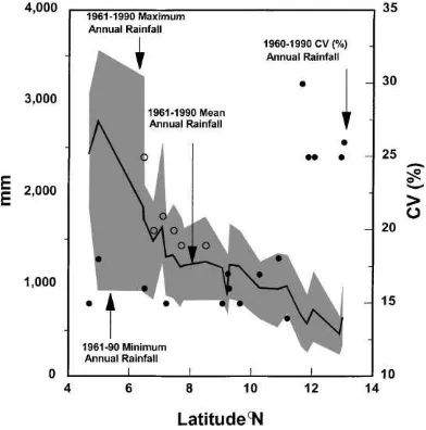
Fig. 2. Variation in 30-year annual rainfall, rainfall range and coefficient of variation ranked by latitudinal position in Nigeria.
annual rainfall shown in Fig. 2 between 1961–1990 over Nigeria reveals that the variability in the rainfall increases with latitude. The coefficient of variation being less than 20% south of 11◦N while it is above
25% north of 11◦N latitude. Also, the rainfall range
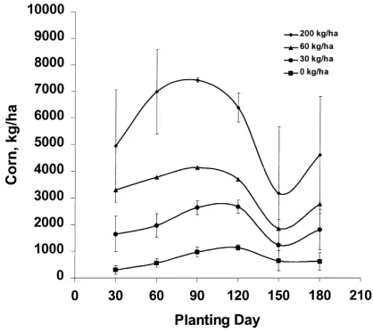
(maximum–minimum) in the south, the humid zone, is three-times that of the drier areas in the north. Thus the yields vary dramatically due to rainfall variability as shown in Fig. 2. Twenty years of daily historical weather data were used at Lagos in the humid zone (Fig. 3) and Kaduna in the sub-humid zone of Nigeria to generate probabilistic estimates of maize yields as-sociated with the nitrogen (N) and variety technology using validated CERES MAIZE model (Jagtap et al., 1993, 1999). At Lagos with 200 kg N/ha, the mean
yield was about 5000±2100 kg/ha for the January
planting and increased to 7430±100 kg/ha for the
Fig. 3. Planting date and nitrogen input effects on the mean and standard deviation of 20-year simulated maize yields at Lagos in Nigeria.
management technologies recommended by research and extension systems. As clearly hypothesized by Anderson World Bank (1993), without risk reducing information, most of the recommended technologies, including chemical fertilizer use, are not likely to be more profitable than existing practices, given the con-strained resources of affected farmers. Most farmers get about 500 kg/ha or less with no fertilizer input. Currently several countries in the region are devel-oping potential for supplying weather information to consumers.
2.2. The sub-humid zone
The sub-humid zone characterized by a growing season of 151–270 days occupies about 1000 million ha extending in a band across West and Central Africa and includes coastal lowlands in eastern and southern Africa. The sub-humid zone can be subdivided into four zones, based on their length of growing period (LGP), vegetation, and agricultural potential. The northern guinea savanna (LGP of 151–180 days), the southern guinea savanna (LGP of 180–210 days); the derived savanna (LGP of 211–270 days); and the coastal savanna (LGP 211–270 days). The rainfall pattern is monomial in the northern and southern guinea savanna, but bimodal in the derived and coastal
savanna. The zone is suited to medium-duration an-nual crops, such as maize, cotton, groundnut, and soy-bean. In the more humid areas of the zone, insolation declines but total biomass production is greater. This provides a comparative ecological advantage for live-stock pastures and longer-duration crops, such as rice, yam and cassava in the southern and tree crops in the derived and coastal savannas. The sub-humid zones of eastern and southern Africa are climatically more fa-vorable for agricultural production than West Africa. Insolation is greater, increasing photosynthesis; tem-peratures are cooler, extending crop growth duration without inhibiting photosynthesis, so that net crop as-similation of photosynthate is increased; and humidity is lower, limiting the importance of fungal diseases.
2.2.1. Production systems
Table 2
Relative area (%) grown to various crops by agroecological zones in West Africa (Manyong et al., 1995)a
Crop Humid zone Derived savanna Southern guinea savanna Northern guinea savanna Other
Maize 18.1 29.2 29.2 21.1 2.4
Cassava 30.0 49.6 14.0 3.1 3.3
Yam 27.1 48.5 18.1 4.9 1.4
Plantain 90.1 9.5 0.0 0.4 0.0
Cowpea 4.3 23.1 31.4 40.4 0.8
Soybean 0.0 80.0 14.3 1.4 4.3
aAreas do not add to 100% due to predominance of mixed cropping.
crop, and some tea, sugarcane, and pineapple are also grown. Many different fruit trees are planted, includ-ing citrus, loquat, avocado, breadfruit, and jackfruit. At the higher altitudes, maize is the dominant cereal, with Phaseolus beans, sweet and Solanum potatoes, bananas, arabica coffee, tea, pyrethrum, and a wide range of vegetables and other crops.
2.2.2. Ecological constraints
Rapidly increasing human and animal population pressures in the savanna zones are driving agriculture towards increasing intensification. Although crops and crop varieties can fit the average LGP in each area, erratic rainfall early in the growing period can cause drought stress. The second rainy season in the derived savanna is unpredictable, making it risky for late ma-turing and drought-susceptible crops, e.g. maize.
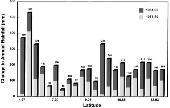
Con-Fig. 4. Decline in the annual rainfall during the 1971–1980 and 1981–1990 decades relative to the 1961–1970 decade at 23 stations in Nigeria ranked by latitude.
less in the northern and southern guinea savanna. The 900, 1100, 1300 and 1500 mm rainfall isohyets were shifted south throughout the country by 167, 138, 108 and 50 km during the same 20 years. The great-est changes occurred in the early season rainfall. The growing season shortened by nearly 1 month during the period 1981–1990 compared with the 1961–1970 decade. The temperatures during the growing season are typically above 23–24◦C. Further decline in rain-fall combined with green house warming could ad-versely affect crop yields. Furthermore, the 1981–1990 decade recorded fewer wet days and therefore much higher rainfall intensities (Jagtap, 1995a). A high pro-portions of rains in Africa are associated with wave disturbances giving rise to strong convective activities which results into short intense storms with peak inten-sities sometimes exceeding 100 mm/h. These intense rains frequently result in considerable compaction, soil erosion and large runoff particularly in the absence of surface cover. Using Fournier (1962) index Jagtap (1995b) estimated that one-thirds of the sub-humid zone lies in moderate erosion risk category while re-maining two-thirds in the high-risk class. Although detailed information is still lacking on both the ero-sivity of the rains and the erodibility of the soils in many parts of Africa, it is clear that the risks of accel-erated erosion are very high in these areas. Improved water harvesting techniques and soil erosion preven-tion methods are rarely used. The zone is widely con-sidered to be the zone at greatest risk of declining agricultural production at present, and parts of it have been severely affected by erosion, soil degradation and drought in recent years. At the same time, the parts that receive adequate rain have an enormous potential for the expansion of rainfed agricultural production.
3. Asia
3.1. Monsoon
Areas in Asia, which have humid and sub-humid climate, generally come under the influence of mon-soon. In India, for example, if monsoon is weak or ar-rives late, crop productions may be severely affected. A strong monsoon creates havoc through wide spread floods damaging crops and property. Most floods occur along lowland areas that are near the rivers,
resulting from high rainfall in upstream catchment areas.
3.2. El Nino/La-Nina
Beside the monsoon, these areas are also affected by El-Nino/La-Nina events that could either enhance or reduce precipitation significantly. The occurrence of dry spells amidst the generally wet weather is not un-common. For example, subsidence farmers in Indone-sia and MalayIndone-sia who practice shifting cultivation, lost most of their crops during the dry weather associated with the recent (1997–1998) El-Nino episode. Irriga-tion is either not practised at all or is in primitive form.
3.3. Wet and dry weather
Water resource is a major constraint in agriculture production in humid and sub-humid Asia. Excessive rain raises water table, which restrict the development of crops. For shallow rooted crops, if the land is in-undated following heavy rainfall, severe damage and even death can occur. In areas with a well-defined dry season, rubber trees which are grown in many areas of the region will ‘winter’ (drop their leaves) during that period. The trees subsequently grow new leaves to form a new canopy, without undue damage by dis-ease. However, in areas without clear dry season, the trees winter during periods of intermittent rain and high humidity. This sustained wet conditions favor the development of Odium, Phytophthora and
Col-letotrichum diseases (Peries, 1979). Sometimes it is
the latex out of the cups, resulting in what is known as ‘wash-out’. When rains fall after tapping, the trick-ling of water down the trunk may interfere with the ‘late-drip’ (Wycherley, 1967).
3.4. Strong wind
In the Asian humid and sub-humid regions, wind speeds are generally in the region of 1–3 m/s with stronger winds in coastal areas, reaching about 4 m/s. However, strong winds in the form of downdrafts from thunderstorms occur frequently. Damages from such strong winds happen in various forms. Annual crops may be lodged and trees may be uprooted on soils with impeded drainage or where rooting has been limited to the surface layers. Young plants may suffer stem bending which requires corrective pruning or roping. Wind can also desiccate the plants during dry spells, thus weakening and predisposing them to diseases. In Indonesia it was found that susceptibility of rubber tree to wind damage was greatest at the time of maximum girthing and canopy development which was related to the branching structure (Dijkman, 1951). Trees with narrow crotches are particularly prone to breakage.
3.5. Forest fires
Forest fires which usually occur during the dry spells, result in not only loss of forest materials but also in widespread haze problem. During the 1997–1998 ENSO warm episode, thousands of hectares of forest in Indonesia were burnt, causing a thick blanket of haze to envelop Indonesia, Malaysia, Singapore and Brunei. Haze not only causes health problems but also reduces incoming solar radiation substantially, thereby lowering crop productions. It has been ob-served that a significant decrease in oil extraction ratio in oil palm bunches in Malaysia appears to be related to the occurrence of widespread haze caused by forest fires in one of her neighbouring country.
3.6. Pests and diseases
Pests and diseases are common in the hu-mid and sub-huhu-mid Asia. The perceptual warm and moist conditions favor the development of many bacteria/virus/vectors. It is not uncommon
for widespread and often excessive use of pesti-cide/insecticide/fungicide to check the spread of these pests and diseases. However, it leads to pollution of the environment. There is a growing opposition among the people to the use of chemicals to con-trol pest and diseases. Pests and diseases particularly affect cocoa, which is grown in many parts of the hu-mid and sub-huhu-mid areas of Asia. Estimates of losses in cocoa production due to diseases indicate values of between 20–30% which are relatively high (Pad-wick, 1956). Air humidity, temperature and rainfall are the major meteorological factors influencing the development of cocoa diseases.
4. Challenges and future prospects
4.1. Technological needs
The literature is replete with references to the inno-vativeness of small farmers in Africa, and the fact that they have adopted new crops and improved practices over a long period of time. A group consisting mainly of African scientists examined whether there currently exists an important stock of appropriate technologies that are under-utilized due to policy and technology transfer constraints (Goldman and Block, 1993). They concluded that much greater emphasis needs to be placed on resource management research emphasiz-ing rainfed systems, timely and reliable climate fore-cast, and intensive production systems. Attempts to introduce input intensive, infrastructure dependent, ir-rigation based technologies into Africa are generally likely to be met with failures, so technologies must rely heavily on internal sources of inputs.
4.2. Agro-meteorological information needs
of various weather/climate factors on crop growth and performance.
4.3. Management of water resources
The demand for fresh water has also risen steadily from agriculture, industry and human usage. A pru-dent water management policy is needed to distribute available water to competing users in order to assure sustainability. There is also a need for vigorous, re-newed investment in irrigation schemes that can raise yields while minimizing economic costs and environ-mental damage. Farmers also know that the correct estimation and interpretation of moisture status of the soil will be of help in deciding the best time for culti-vation, sowing, fertilizer applications and to maximize use of limited water. Standard procedures are now available for estimation of crop water consumption us-ing weather data as drivus-ing inputs. Such information needs to be disseminated widely to farmers. Methods to better predict occurrence, continuation and cessa-tion of drought need to be developed. These methods should also consider the soil characteristics and topog-raphy of the area involved. Such technique has been used by various nations, particularly India, to help in planning of crop sequence.
4.3.1. Early warning system
To be able to obtain and make available the infor-mation of the weather and its impact on agriculture in the scale of the country, a national early warning sys-tem needs to be set up in each country. The syssys-tem can be used not only to mitigate the impact of bad weather but also to help farmers to benefit from the effects of favorable weather. It also assists policy makers in their formulation of marketing strategies. In this aspect, a Geographical Information System (GIS), a well-tested software, and satellite information will be of immense help. It is useful and appropriate for national meteoro-logical agencies to acquire GIS in order to better serve the agriculture community. In Malaysia, the employ-ment of satellite information has been used to monitor the performance of rice in her main rice bowl area. A normalized vegetative index based on the values of two channels of the NOAA satellite had been de-rived. The index was observed to be related with the amount of biomass of the crop. This exercise can be
further developed into a comprehensive early warning system.
4.3.2. Pest/disease management
The threat of pest or disease losses is so great in some agricultural practices that preventive or cura-tive action in the form of regular periodic spraying is often taken. This may be effective, but it is not always economical and it has opened door to possi-ble environmental pollution. Farmers now recognize that a sensible form of protection is to base applica-tion of insecticide/pesticide on weather condiapplica-tions and know the relationship between the development of the pest/disease and other environmental (beside weather) factors. The need for such techniques has been ex-pressed often. However, limited resources within me-teorological agencies only allow them to meet a very few of these needs.
4.3.3. Micrometeorology
In annual crops of small stature, periodic destruc-tive sampling of a portion of the crop can assess pro-ductivity. The carbon dioxide exchange with the atmo-sphere can be determined by enclosing the plants in suitably ventilated chamber that measures the carbon dioxide concentrations of the incoming and outgoing air streams. However, such methods are inappropriate for large perennial tree crops such as oil palm, rubber and cocoa due to high cost of equipment, consider-able technical expertise to operate and maintain them and the magnitude and complexity of data handling. In view of the importance to the climate and agricul-ture of crop cover in the tropics, there is a need to ex-tend the usage of such techniques to the tropics. Such extension will not only meet the need to monitor the exchanges of gases and momentum over tropical crop cover but also facilitate the development of technical resources in developing nations.
4.4. User requirements
4.4.1. Growing demand for agrometeorological services
the national meteorological agencies were trying to educate and encourage the use of agrometeorological services in agricultural activities. Besides requesting for weather forecast, the next most common area that the agriculture sectors sought help was to know what crop(s) to grow at a given location or where to grow a selected crop. This question requires more background work before it can be satisfactorily answered. Some agricultural agencies particularly the research insti-tutes have indicated the need to develop crop-weather models to simulate growth and development of crops. Investigations in this area are still being actively pur-sued and will likely yield more promising results for future practical application on a wider scale. The me-teorological staff needs more training to cope up with the demand of agrometeorological services.
4.4.2. Better weather forecast
The need of accurate weather forecasts by farmers is one of their main requirements in agrometeorological services. The farmers need weather forecasts to plan and organize their field activities. Accuracy of the tim-ing and as well as the location of weather phenomenon are often crucial to their activities. In the earlier days, the most common expressed need in the use of mete-orology in agriculture is simple short-range weather forecasts to plan or guide operational activities. Grad-ually, the request extended to medium and long-range weather forecasts. Today, some agricultural agen-cies are using short and medium range forecasts for planning daily, weekly and even monthly operational field activities and long-range forecasts (quarterly to 1 year) to manage long term agricultural planning. The capability of general circulation models coupled with an ocean model to predict ENSO warm and cold episodes has increased the reliability and usefulness of long-range weather forecasts. This has helped the agricultural community to be better prepared for the coming favorable or unfavorable weather conditions.
4.4.3. Micrometeorological techniques
The request for micrometeorological measurements in crop canopies has also increased. Users need help to measure fluxes of momentum, gases and water vapor in crop canopies. Information and methods on artifi-cial modification of microclimate by means of shel-ter belt, shading, mulching, evaporation suppression
and others which alter the conditions of the air or soil or air–soil interface surrounding the crops are also required. However, due to lack of human and finan-cial resources, meteorological services could not meet most of these needs.
4.5. Application tools
Agriculture,‘the most weather-dependent of all hu-man activities’ (Oram, 1989), is the endeavored most critical for human survival and the most important sector of most national economies. People in Africa and Asia are particularly vulnerable to the impacts of weather variability on agriculture due to its overde-pendence on rainfed agriculture. Agricultural vulner-ability to weather varivulner-ability is expected to increase as the population increases and more marginal lands are brought into production. One of the reasons that cli-mate variability is often so devastating to agriculture is that we do not know when to expect either favorable or unfavorable weather conditions, and we are thus unprepared. Many critical agricultural decisions from timing of farm operation to policy-making have com-plex interactions with weather conditions and must be made several months before the impact of weather. If farmers had better weather predictions that are made sufficiently ahead of time, it may be possible to modify decisions to decrease unwanted impacts and take advantage of favorable conditions. Conventional empirical approaches are inadequate for addressing the complexity of the interactions between global cli-mate, regional weather variability, decision making, agricultural productivity and economic responses. The rapidly advancing information technology offers opportunities and challenges to agrometeorologists to improve the service of meteorology to agriculture. Information may be communicated through electron-ically using, for example, the Internet or networking. These means offers fast way to disseminate agrom-eteorological information in useful formats to users. Research findings and new methodologies can be packaged into user-friendly software for distribution among agricultural users.
4.5.1. Agroclimatic zonation
have divided their country into agroclimatic zones. These exercises essentially graded areas into suitabil-ity zones according to the degree to which the cli-matic and soil resources have met the requirements of selected crops. Maps have been produced for ma-jor crops of each country. However, the complexity in the zonation and scale of the maps differ among the nations. The usefulness of the agroclimatic and crop suitability maps depends on the accuracy of the data used, the viability of the methodology and the scale of the maps. If the climate and soil data employed in the exercise is not reliable, and then the maps are not only useless but also harmful because they could mislead planners. A common characteristic of soil and climate data is that they have significant spatial variation. This factor also relates to the scale of the map. If the spa-tial distribution of the data is sparse, then the maps need to be of smaller scales. It is pointless to produce detailed maps using a coarse data set. However, maps without enough spatial details are not practically use-ful. On the other hand, maps with proper scales are tools that agriculture planners or managers will not want to do without. Whether the method used in delin-eating area into agroclimatic or crop suitability zones is viable depends on how much is known about the crops, particularly their behavior in the changing envi-ronment, and how well the climate of the location has been monitored. Presently in most part of the coun-try, there are, relatively speaking, more reliable and available climate data with respect to time and space than crop data. However, enough is now known about crops in general that it can be used to guide planning activities in a more objective and scientific manner. A good agroclimatic and crop suitability zonation should also include information on unsuitability of crops/sites for chosen sites/crops. This information will help to prevent misuse of land resources with possible conse-quences of failures of agricultural projects. Such fail-ures have serious adverse impacts not only on the eco-nomics but also on the social-welfare of the people involved in the projects.
4.5.2. Computer-assisted farming
Advances in computer technology have been used to improve agriculture. Software has been produced to assist agricultural activities. An example of this is the ‘Enviromax’ — a PC-based user-friendly soft-ware for selecting rubber-planting material (Rubber
Research Institute of Malaysia, 1983). In this system, the rubber-growing areas have been divided into envi-ronments according to factors (e.g. wind damage and fungal diseases) that act as constraints in the selec-tion of clones. Clones are recommended based on the underlying principle of maximizing the yield poten-tial of a particular locality, subject to the inhibitory influence of wind damage, fungal diseases, problem-atic soils and terracing, and moisture stress. The soft-ware is distributed with a small charge to plantation rubber growers, thus enabling the widespread use of proper planting technology (Leong, 1991). This soft-ware is meant for professional rubber grower who has some knowledge on rubber cultivation. Another ex-ample is DSSAT, the computer software for the deci-sion support systems which enables research scientists throughout the world to gain access to the latest agro-nomic understanding of major food crops, now en-capsulated within computer simulation models (Jones, 1993).
A good example of the use of information tech-nology is demonstrated by the China Meteorologi-cal Administration that developed practiMeteorologi-cal software for agricultural use. The meteorological agency has a pool of software experts that work in teams, often for years, to develop programs that meet specific agri-cultural needs. Some examples are the programs de-veloped to use satellite data for monitoring crop per-formances, land-use change, floods, and forest fire. A specific example is the software entitled Agrometeoro-logical Information and Prediction System developed by the staff of Jiangsu Provincial Meteorological Bu-reau. This program enabled a central office to receive and decode agrometeorological information from sur-rounding stations, predict the productions of crops, an-alyze historical data and communicate the information to users.
4.5.3. Integrated pest/disease management system
loca-tions, a number of cocoa diseases can be controlled by simple field sanitation which might involve a change in level of shade, or improved drainage, though in other cases spraying may be necessary. Considerable success in controlling of cassava mealybug has been achieved in Africa using biological control agents col-lected from ecologically similar areas where cassava originated. This was made possible using meteorolog-ical homologues in the two continents (Neuenschwan-der et al., 1989).
4.5.4. Crop modelling
Models have been developed for projecting the yields of crops. Some of them are statistical models while others are process-based simulation models. Described further are some examples and uses of these models. There were studies (Robertson and Foong, 1977; Foong, 1981) which predict yields based on climatic factors using mathematical modelling. Factors used were water deficit, solar radiation, maxi-mum and minimaxi-mum temperatures. These factors were found to be important at times corresponding to floral initiation, sex differentiation, spear elongation and abortion. In another study by Ong (1982) in southern Malaysia, high correlation was found between yield and rainfall and dry spells with temperature and sun-shine also being taken in consideration. Chow (1991) using a step-wise regression approach constructed a statistical model of crude palm oil production yield with trend, season, rainfall and lagged yield. He found that 53–57% of the variation in crude palm oil pro-duction can be explained by season effect, 12–24% by rainfall and 10–20% by lagged yield effect. Similarly, using solar radiation data, Chan (1991) presented a simple method of predicting the potential yield of oil palm of an area.
Use of the DSSAT family of models in Africa has been concerned with making better use of available resources to optimize crop production in climatically variable regions. In recent years, many parts of Africa, has witnessed phenomenal growth in maize produc-tion replacing tradiproduc-tional crops such as sorghum and pearl millet. However maize is generally considered to be more susceptible to drought than sorghum or the millets, and because of the uncertainty of the rains, there is a high risk of crop failure. Evidence also shows that even in the case of Maize, a crop noted for its high input demands, fertilizer use by farmers is low
(Byerlee and Heisey, 1992). Nitrogen use efficiency is often poor because of a number of loss mechanisms whose extent and relative importance depend on the amount of rainfall received, fertilizer type, crop, fertil-izer/crop management, soil and climatic factors (Legg and Meisinger, 1982).
In an attempt to assess nitrogen requirement by maize across agroecological zones in Nige-ria, Amissah-Arthur and Jagtap (1995) used the CERES-Maize model to simulate seasonal variability in maize yield subjected to rainfall and N fertilization. The sites (Onne, Ibadan, Kaduna, and Kano) differed greatly in terms of rainfall received, thus providing contrasting conditions for maize production. Seasonal rainfall across the sites were divided into low, normal and high rainfall seasons on the basis of cumulative probability of growing season rainfall deviations from the mean. Large yield responses to N levels among sites and between seasons were observed because of seasonal rainfall variability. During normal rainy seasons, farmers could heavily fertilize their maize without undue risk of crop failure. The risk could be further reduced by strategies that minimize N losses by mulching or split applications. The simu-lation study showed that the ‘optimum management’ strategy varied among the zones to N and rainfall regime. Therefore, it may be impossible to identify a single fertilizer strategy that is optimal across sites and seasons. Linking climatic forecasts of expected seasonal rainfall with appropriate crop models would enable assessment of the cropping potential of a pe-riod or area and the risks of yield variability. Such information could enable tactical intra-seasonal crop management planning and decision making especially as regards fertilizer use.
5. Summary
ma-jor crops to guide farmers and development agencies. However, these maps often do not include information on unsuitability of crops/sites for chosen sites/crops. Conventional empirical approaches are inadequate for addressing the complexity of the interactions be-tween global climate, regional weather variability, decision making, agricultural productivity and eco-nomic responses. Models have been developed for projecting the yields of crops. The rapidly advanc-ing computer technology and information technology offers opportunities and challenges to agrometeo-rologists to improve the service of meteorology to agriculture.
Unpredictable weather, limited and erratic rainfall, nutrient poor soil and rapid intensification of agri-culture is major ecological limits of the humid and sub-humid zones of Asia and Africa. The inter and intra-annual variability in rainfall is perhaps the key factor that determines success of agriculture. In the years when the rainy seasons start late and there may be less than average rainfall, all these have enormous effects on farming systems. The reasons for these variations do not appear to be understood at present, and would seem to deserve considerably increased research effort. One of the most difficult factors, with which farmers must contend, is rainfall variability. Although farmers always have some traditional rough and ready knowledge of rainfall patterns in their own areas, they may often be taken by surprise by changes in the ‘normal’ rainfall patterns, particularly if a run of wet years is followed by several dry years. The potential exists in rainfed agriculture to improve management of soil nutrients and therefore reduce risks and increase yields by taking into account char-acteristics of agroecological zones. Due to lack of finance in the countries of the region, the networks of agrometeorological stations do not adequately cover their various agrometeorological zones. Often, there is none or very little climate data or information to help in making decisions for initiating agricultural projects. Through advances in atmospheric research, weather forecasting has improved. However, weather forecasts are still far from being perfect, and the longer the periods of validity of the forecasts the more unreliable they tend to be. The general lack of confidence in the reliability of weather forecasts has caused farmers not to trust and use the weather forecasts. This lack of confidence also affects other
areas of agrometeorological services provided by the national meteorological agency.
References
Amissah-Arthur, A., Jagtap, S.S., 1995. Application of models and geographic information system based decision support system in analysing the effect of rainfall on maize yield stability. Sustain Africa 3, 2–15.
Anderson World Bank, 1993. World Development Report 1993: Investing in Health. World Bank, Washington, DC.
Byerlee, D., Heisey, P., 1992. Strategies for technical change in small-farm agriculture, with particular reference to sub-Saharan Africa. In: Russell, N.C., Doswell, C.R. (Eds), Proceedings of the Workshop, on the Policy Options for Agricultural Development in Sub-Saharan Africa, Airlee House, Virginia. CASIN/SAA/Global 2000, Mexico, DT.
Chan, K.W., 1991. Predicting oil palm yield potential based on solar radiation. Second National Seminar on Agrometeorology, Petaling Jaya, Malaysia, pp. 129–140.
Chow, C.S., 1991. Seasonal and rainfall effects on oil palm yield in Malaysia. Second National Seminar on Agrometeorology, Petaling Jaya, Malaysia, pp. 109–128.
Davies, S., 1969. Adaptable Livelihoods: Coping with Food Insecurity in the Malian Sahel. Macmillan, London.
Dijkman, M.J., 1951. Hevea. Thirty Years of Research in the Far East. University of Miami Press.
FAO (Food and Agriculture Organization of the United Nations), 1996. African Agriculture: The Next 25 Years Annex II. The Land Resource Base. ARC/86/3, FAO, Rome, Italy.
Foong, S.F., 1981. An improved weather model for estimating oil oalm fruit yield. The Oil Palm in Agriculture in the Eighties, ISP, Malaysia.
Fournier, F., 1962. Map of Erosion Danger in Africa South of the Sahara. Technical Centre for Agricultural and Rural Cooperation, European Economic Community, Wageningen, Netherlands.
Goldman, R.H., Block, S. (Eds.), 1993. Proceedings from the Symposium on Agricultural Transformation in Africa, ARAP II. Technical Report No. 137, Abt Associates, Cambridge, MA, USA.
IITA (International Institute of Tropical Agriculture), 1988. IITA Strategic Plan: 1989–2000. IITA, Ibadan, Nigeria.
IPCC, 1990. Climate Change: The IPCC Scientific Assessment. In: Houghton, J.T., Jenkins, G.J., Ephraums, J.J., (Eds.), Intergovernmental Panel on Climate Change. Cambridge University Press, Cambridge, UK.
Jagtap, S.S., Mornu, M., Kang, B.T., 1993. Simulation of growth, development, and yield of maize in the transition zone of Nigeria. Agric. Syst. 41, 215–229.
Jagtap, S.S., 1995a. Changes in annual seasonal and monthly rainfall in Nigeria during 1961–1990 and consequences for agriculture. Discovery and Innovations 7 (4), 337–348. Jagtap, S.S., 1995b. Environmental characterization of the moist
Manyong, V.M., Carsky, R.J., Sanginga, N., Kueneman, E.A. (Eds.), Proceedings of the International Workshop, Cotonou, Republic of Benin, 19–23 September 1994. International Institute of Tropical Agriculture, Ibadan, Nigeria.
Jagtap, S.S., Abamu, F., Kling, J., 1999. Longterm assessment of nitrogen and variety technologies. Agric. Syst. 60 (2), 77–86. Jahnke, H.E., 1982. Livestock production systems and livestock
development in tropical Africa. Kielers Wissechoftoverlag Vank, Kiel, Germany.
Jones, J.W., 1993. Decision support system for agricultural development. In: Penning de Vries, F.W.T., Teng, P.S., Meselaar, K. (Eds.), Systems Approaches to Agricultural Development. Kluwer Academic Publishers, Dordrecht, The Netherlands, pp. 459–472.
Kang, B.T., 1993. Changes in soil chemical properties and crop performance with continuous cropping on an entisol in the humid tropics. In: Mulongoy, K., Merckx, R. (Eds.), Proceedings on International Symposium on Soil Organic Matter Dynamics and Sustainability of Tropical Agriculture, Ibadan, Nigeria, 1992. Wiley, Chichester, New York. Legg, J.O., Meisinger, J.J., 1982. Soil nitrogen budgets. Nitrogen
in Agricultural Soils. ASAE, Madison, WI, pp. 503–557. Leong, Y.S., 1991. Enviromax : An expert system for rubber
planting. Second National Seminar on Agrometeorology, Petaling Jaya, Malaysia, pp. 141–150.
Manyong, V.M., Smith, J., Weber, G.K., Jagtap, S.S., Oyewole, B., 1995. Macrocharacterization of Agricultural Systems in West Africa: An Overview. Research and Crop Management Research, Monograph No. 21, International Institute of Tropical Agriculture, Ibadan.
Neuenschwander, P., Hammond, W.N.O., Guteirrez, A.P., Codjoe, A.R., Baumgartner, J.U., 1989. Impact assessment of the biological control of the cassava mealybug Phenacoccus
manihoti Mantile-Ferrero (Hemiptera: Pseudococcidae) by
the introduced parasitiod Epidinocarsis lopezi (De Santis) (Hymenoptera: Encyyrtidae). Bull. Entomological Res. 79, 579–594.
Oram, P.A., 1989. Sensitivity of agricultural production to climate change, an update. Climate and Food Security. IRRI, Manila, The Phillipines, pp. 25–44.
Ong, H.T., 1982. System approach to climatology of oil palm 1. Identification of rainfall and dry spell aspects 2. Identification of temperature and sunshine. Oleagineux 37, 93,–443. Padwick, G.W., 1956. Losses cost by plant diseases. Colonies.
Phytopathological Paper No. 1, Commonwealth Mycological Inst., Kew Garden, UK.
Peries, O.S., 1979. Studies on the relationship between weather and incidence of leaf diseases of Hevea. Planter (Kuala Lumpur) 55, 158–169.
Robertson, G.W., Foong, S.F., 1977. Weather-based yield forecasts for oil palm fresh fruit bunches. International Development in Oil Palm, ISP, Kuala Lumpur.
Rubber Research Institute of Malaysia, 1983. RRIM planting recommendations 1983–85. Planters’ Bulletin of the Rubber Research Institute of Malaysia No. 175, p. 355.
Winrock International, 1992. Assessment of animal agriculture in sub-Saharan Africa. Winrock International Institute for Agricultural Development, Morrilton, AR.