Open Geospatial Consortium
Approval Date: 2012-06-23 Publication Date: 2012-09-07 Reference number of this OGC® project document: OGC 10-126r3
OGC name of this OGC® project document: http://www.opengis.net/doc/IS/waterml/2.0 Version:2.0 Category: OGC® Implementation Standard
Editor: Peter Taylor
OGC
®WaterML 2.0: Part 1- Timeseries
Copyright notice
Copyright © 2012 Open Geospatial Consortium
To obtain additional rights of use, visit http://www.opengeospatial.org/legal/.
Notice
This document is an OGC Member approved international standard. This document is available on a royalty free, non-discriminatory basis. Recipients of this document are invited to submit, with their comments, notification of any relevant patent rights of which they are aware and to provide supporting documentation.
Document type: OGC® Implementation Standard Document subtype: Encoding
OGC 10-126 WaterML 2.0
License Agreement
Permission is hereby granted by the Open Geospatial Consortium, ("Licensor"), free of charge and subject to the terms set forth below, to any person obtaining a copy of this Intellectual Property and any associated documentation, to deal in the Intellectual Property without restriction (except as set forth below), including without limitation the rights to implement, use, copy, modify, merge, publish, distribute, and/or sublicense copies of the Intellectual Property, and to permit persons to whom the Intellectual Property is furnished to do so, provided that all copyright notices on the intellectual property are retained intact and that each person to whom the Intellectual Property is furnished agrees to the terms of this Agreement.
If you modify the Intellectual Property, all copies of the modified Intellectual Property must include, in addition to the above copyright notice, a notice that the Intellectual Property includes modifications that have not been approved or adopted by LICENSOR. THIS LICENSE IS A COPYRIGHT LICENSE ONLY, AND DOES NOT CONVEY ANY RIGHTS UNDER ANY PATENTS THAT MAY BE IN FORCE ANYWHERE IN THE WORLD.
THE INTELLECTUAL PROPERTY IS PROVIDED "AS IS", WITHOUT WARRANTY OF ANY KIND, EXPRESS OR IMPLIED, INCLUDING BUT NOT LIMITED TO THE WARRANTIES OF MERCHANTABILITY, FITNESS FOR A PARTICULAR PURPOSE, AND NONINFRINGEMENT OF THIRD PARTY RIGHTS. THE COPYRIGHT HOLDER OR HOLDERS INCLUDED IN THIS NOTICE DO NOT WARRANT THAT THE FUNCTIONS CONTAINED IN THE INTELLECTUAL PROPERTY WILL MEET YOUR REQUIREMENTS OR THAT THE OPERATION OF THE INTELLECTUAL PROPERTY WILL BE UNINTERRUPTED OR ERROR FREE. ANY USE OF THE INTELLECTUAL PROPERTY SHALL BE MADE ENTIRELY AT THE USER’S OWN RISK. IN NO EVENT SHALL THE COPYRIGHT HOLDER OR ANY CONTRIBUTOR OF INTELLECTUAL PROPERTY RIGHTS TO THE INTELLECTUAL PROPERTY BE LIABLE FOR ANY CLAIM, OR ANY DIRECT, SPECIAL, INDIRECT OR CONSEQUENTIAL DAMAGES, OR ANY DAMAGES WHATSOEVER RESULTING FROM ANY ALLEGED INFRINGEMENT OR ANY LOSS OF USE, DATA OR PROFITS, WHETHER IN AN ACTION OF CONTRACT, NEGLIGENCE OR UNDER ANY OTHER LEGAL THEORY, ARISING OUT OF OR IN CONNECTION WITH THE IMPLEMENTATION, USE, COMMERCIALIZATION OR PERFORMANCE OF THIS INTELLECTUAL PROPERTY. This license is effective until terminated. You may terminate it at any time by destroying the Intellectual Property together with all copies in any form. The license will also terminate if you fail to comply with any term or condition of this Agreement. Except as provided in the following sentence, no such termination of this license shall require the termination of any third party end-user sublicense to the Intellectual Property which is in force as of the date of notice of such termination. In addition, should the Intellectual Property, or the operation of the Intellectual Property, infringe, or in LICENSOR’s sole opinion be likely to infringe, any patent, copyright, trademark or other right of a third party, you agree that LICENSOR, in its sole discretion, may terminate this license without any compensation or liability to you, your licensees or any other party. You agree upon termination of any kind to destroy or cause to be destroyed the Intellectual Property together with all copies in any form, whether held by you or by any third party. Except as contained in this notice, the name of LICENSOR or of any other holder of a copyright in all or part of the Intellectual Property shall not be used in advertising or otherwise to promote the sale, use or other dealings in this Intellectual Property without prior written authorization of LICENSOR or such copyright holder. LICENSOR is and shall at all times be the sole entity that may authorize you or any third party to use certification marks, trademarks or other special designations to indicate compliance with any LICENSOR standards or specifications.
Contents
i. Preface ... ix
ii. Submitting Organizations ... ix
iii. Submission Contact Points ... x
iv. Future Work ... x
v. Changes to the OGC® Abstract Specification ... xi
1 Scope ... 3
2 Conformance ... 4
3 Normative References ... 5
4 Terms and Definitions ... 6
5 Conventions ... 8
5.1 Abbreviated terms ... 8
5.2 UML notation ... 8
5.3 Finding requirements and recommendations ... 9
6 Overview of WaterML2.0 ... 10
7 Observations and Measurements overview ... 12
7.1 Sampling features ... 12
8 The nature of hydrological observations ... 13
8.1 Observations and forecasts ... 15
9 UML Conceptual Models (normative) ... 15
9.1 Structural overview of requirements classes ... 15
9.2 Package dependencies ... 17
9.3 Use of vocabularies ... 19
9.4 Requirements class: Timeseries Observation ... 20
9.5 Time series observation specialisations ... 27
9.6 Requirements class – Timeseries (domain range) Observation ... 28
9.7 Requirements class – Measurement Timeseries (domain range) Observation ... 29
9.8 Requirements class – Categorical Timeseries (domain range) Observation ... 30
9.9 Requirements class – Timeseries time-value pair (interleaved) Observation ... 31
OGC 10-126 WaterML 2.0
9.11 Requirements class – Categorical Timeseries time-value pair (interleaved)
Observation ... 32
9.12 Requirements class: Timeseries (Core) ... 33
9.13 Requirements class: Timeseries Domain-Range ... 42
9.14 Requirements class: Timeseries Time-Value Pair (interleaved) ... 43
9.15 Requirements class: Measurement Timeseries TVP (interleaved) ... 45
9.16 Requirements class: Categorical Timeseries TVP (interleaved) ... 56
9.17 Requirements class: Measurement Timeseries (Domain-Range) ... 57
9.18 Requirements class: Categorical Timeseries (Domain-Range) ... 58
9.19 Requirements class: Monitoring Points ... 59
9.20 Requirements class: Monitoring Point feature of interest ... 64
9.21 Requirements class: Sampling Feature Collections ... 64
9.22 Requirements class: Observation process ... 65
9.23 Requirements Class: Collection ... 68
10 XML Implementation (normative) ... 72
10.1 Scope of XML implementation ... 73
10.2 XML encoding principles ... 75
10.3 Requirements Class: XML Rules ... 75
10.4 Requirements Class: Timeseries Observation ... 77
10.5 Requirements Class: Timeseries Time-Value Pair (interleaved) Observation ... 79
10.6 Requirements Class: Measurement time-value pair Timeseries (interleaved) Observation ... 80
10.7 Requirements Class: Categorical time-value pair Timeseries (interleaved) Observation ... 81
10.8 Requirements Class: Timeseries – time-value pair representation ... 81
10.9 Requirements Class: Measurement Timeseries – time-value pair representation ... 83
10.10 Requirements Class: Categorical Timeseries – time-value pair representation ... 87
10.11 Requirements Class: Monitoring point as feature of interest ... 88
10.12 Requirements Class: Observation Process ... 89
10.13 Requirements Class: Monitoring Point ... 90
10.14 Requirements Class: Collection ... 91
A.1 Conformance classes - UML Package ... 92
A.1.1 Conformance Class: Timeseries Observation ... 92
A.1.3 Conformance Class: Measurement (Domain Range) Timeseries
Observation ... 94
A.1.4 Conformance Class: Categorical (Domain Range) Timeseries Observation ... 95
A.1.5 Conformance Class: TVP Timeseries Observation ... 95
A.1.6 Conformance Class: Measurement TVP Timeseries Observation ... 96
A.1.7 Conformance Class: Categorical TVP Timeseries Observation ... 96
A.1.8 Conformance Class: Timeseries Core ... 97
A.1.9 Conformance Class: Timeseries Domain Range ... 99
A.1.10 Conformance Class: Timeseries Time-Value Pair (interleaved) ... 99
A.1.11 Conformance Class: Measurement Timeseries TVP (Interleaved) ... 100
A.1.12 Conformance Class: Categorical Timeseries TVP (Interleaved) ... 101
A.1.13 Conformance Class: Measurement Timeseries (Domain Range) ... 101
A.1.14 Conformance Class: Categorical Timeseries (Domain Range) ... 101
A.1.15 Conformance Class: Monitoring Point ... 102
A.1.16 Conformance Class: Monitoring Point feature of interest ... 102
A.1.17 Conformance Class: Sampling feature collections ... 103
A.1.18 Conformance Class: Observation process ... 103
A.1.19 Conformance Class: Collection ... 104
A.2 Conformance classes – XML Implementation ... 105
A.2.1 Conformance Class: XML Rules ... 105
A.2.2 Conformance Class: Timeseries Observation XML (abstract) ... 107
A.2.3 Conformance Class: TVP (Interleaved) Timeseries Observation XML ... 108
A.2.4 Conformance Class: Measurement TVP (Interleaved) Timeseries Observation XML ... 109
A.2.5 Conformance Class: Categorical TVP (Interleaved) Timeseries Observation XML ... 109
A.2.6 Conformance Class: Timeseries (Core) ... 110
A.2.7 Conformance Class: Timeseries – TVP representation ... 111
A.2.8 Conformance Class: Measurement Timeseries – TVP representation ... 113
A.2.9 Conformance Class: Categorical Timeseries – TVP representation ... 115
A.2.10 Conformance Class: Monitoring point feature of interest ... 115
A.2.11 Conformance Class: Observation Process ... 116
A.2.12 Conformance Class: Monitoring Point ... 116
A.2.13 Conformance Class: Collection ... 117
OGC 10-126 WaterML 2.0
C.2 Routine operational forecasting activity in support of infrastructure
operation ... 125
C.3 Exchange of groundwater levels across international borders ... 126
C.4 Generic data exchange scenario between stakeholders ... 127
Table of Figures
Figure 1 - Observation as defined by O&M ... 12
Figure 2 – The hydrologic cycle [4] ... 13
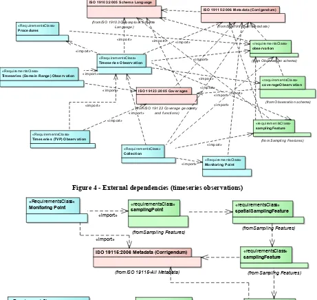
Figure 3 – Internal package dependencies ... 17
Figure 4 - External dependencies (timeseries observations) ... 18
Figure 5 - External dependencies (monitoring points) ... 18
Figure 6 - External dependencies (timeseries) ... 19
Figure 7 - Observation specialisation ... 22
Figure 8 - Observation metadata ... 25
Figure 9 - Observation types as related to ISO19156 (green) and ISO19123 (red) ... 27
Figure 10 - Relationship to CVT_TimeInstantCoverage (ISO19156 – Annex C, green) 28 Figure 11 - Measurement timeseries (domain range) observation ... 29
Figure 12 - categorical timeseries (domain range) observation ... 30
Figure 13 - Timeseries (TVP) Observation ... 31
Figure 14 - Measurement timeseries (TVP) Observation ... 32
Figure 15 - Categorical timeseries (TVP) Observation ... 33
Figure 16 - Timeseries base type and relationship to coverages ... 35
Figure 18 - Timeseries as a coverage ... 38
Figure 19 - Timeseries metadata ... 39
Figure 20 – Timeseries point metadata ... 40
Figure 21 - Timeseries using domain-range view ... 43
Figure 22 - Timeseries using time-value (interleaved) view ... 44
Figure 23 - Measurement Timeseries (TVP) ... 46
Figure 24 - Anchor points ... 47
Figure 25 - Connecting two time series ... 48
Figure 26 - A cumulative series ... 49
Figure 27 - Example accumulated series ... 49
Figure 28 - Categorical timeseries (TVP) ... 57
OGC 10-126 WaterML 2.0
Figure 30 - Categorical timeseries (domain range) ... 59
Figure 31 - MonitoringPoint ... 62
Figure 32 - SF_SamplingFeatureCollection as defined by ISO19156 ... 65
Figure 33 - Observation process feature type ... 66
i. Preface
The primary goal of this profile is to capture the semantics of hydrological observational data for data exchange. This will allow hydrological information systems to communicate data between systems and to end users.
ii. Submitting Organizations
The following organizations submitted this Implementation Profile to the Open Geospatial Consortium Inc.:
a) CSIRO
b) San Diego Supercomputer Center c) Australian Bureau of Meteorology
d) Geological Survey of Canada, Natural Resources Canada e) USGS
f) KISTERS AG g) NOAA
h) Deltares
i) Federal Waterways Engineering and Research Institute j) disy Informationssysteme GmbH
OGC 10-126 WaterML 2.0
iii. Submission Contact Points
All questions regarding this submission should be directed to the editor or the submitters:
Contact Company Email
Peter Taylor CSIRO peter.taylor at csiro.au
David Valentine CUAHSI valentin at sdsc.edu
Gavin Walker CSIRO gavin.walker at csiro.au
I-Lin Kuo USGS ilinkuo at usgs.gov
Paul Sheahan Australian Bureau Of Meteorology p.sheahan at bom.gov.au Eric Boisvert Natural Resources Canada eric.boisvert at
RNCan-NRCan.gc.ca
John Halquist NOAA john.halquist at noaa.gov
Peter Gijsbers Deltares peter.gijsbers at deltares-usa.us Michael Natschke KISTERS AG michael.natschke at kisters.de Michael Utech KISTERS AG michael.utech at kisters.de Stefan Fuest KISTERS AG stefan.fuest at kisters.de
Touraj Farahmand Aquatic Informatics tourajf at aquaticinformatics.com
David Blodgett USGS dblodgett at usgs.gov
David Briar USGS dbriar at usgs.gov
Sylvain Grellet International Office For Water - Sandre s.grellet at oieau.fr
Carsten Heidmann disy Informationssysteme GmbH carsten.heidmann at disy.net
Irina Dornblut GRDC dornblut at bafg.de
Jens Wilhelmi German Federal Institute of Hydrology wilhelmi at bafg.de
Simon Cox CSIRO simon.cox at csiro.au
Doug Palmer CSIRO doug.palmer at csiro.au
Tim Whitaker CUAHSI twhit at mail.utexas.edu
iv. Future Work
- Specification of an ex-situ (e.g. water quality) profile
- Inclusion of further complex structures (e.g. rating curves, conversion tables etc.) - Harmonizing time series structures with other standards (GML values vs. SWE
Common vs. coverage types) and profiles (CSML, netCDF, SWE Common Profiles etc.)
v. Changes to the OGC
®Abstract Specification
The OGC® Abstract Specification requires changes to accommodate this OGC® Standard. 1. TimeSeries needs to be added to Topic 6 (aka ISO 19123), and it needs to be in a
way that supports both TVP and DR forms
2. ObservationCollection needs to be added to Topic 20/ISO 19156 (O&M)
OGC 10-126 WaterML 2.0
Foreword
This work has, for the most part, been funded through a water information research and development alliance between CSIRO‘s Water for a Healthy Country Flagship and the Australian Bureau of Meteorology. The work has also been supported by The Consortium for the Advancement of Hydrological Sciences Inc. (CUAHSI). The work is operating under the joint World Meteorological Organisation (WMO) and Open Geospatial Consortium (OGC) Hydrology Domain Working Group [1].
Attention is drawn to the possibility that some of the elements of this document may be the subject of patent rights. Open Geospatial Consortium shall not be held responsible for identifying any or all such patent rights. However, to date, no such rights have been claimed or identified.
Recipients of this document are requested to submit, with their comments, notification of any relevant patent claims or other intellectual property rights of which they may be aware that might be infringed by any implementation of the specification set forth in this document, and to provide supporting documentation.
Introduction
Motivation
The increasing global demand on fresh water supplies is putting increased pressure on the natural resource environment. This demand is leading nations to improve terrestrial water monitoring facilities to better understand the amount, and the quality, of fresh water resources.
Traditional water monitoring networks consist of regional monitoring programs that help to address issues of direct significance, such as flood warnings, providing water management guidelines (applying restrictions, setting allocations etc.), drought management and so on. More recently, nations are moving towards more holistic structuring of monitoring systems in order to provide an integrated national view on the state of water resources.
This has led to a requirement on monitoring programs to exchange their data with other organisations that may have an interest in the observational data collected. National monitoring programs that often aggregate smaller, locally maintained monitoring networks, are requesting data for the use in national reporting facilities.
In addition to this is the increased need for the exchange of data to improve our understanding of complex environmental processes, such as climate change. Terrestrial water movement can play a significant influencing role in such processes; cross-domain scientific enquiry and modelling requires access to increasing set of observational data, including hydrological observations. A report from the Global Climate Observing System (GCOS) into data exchange problems in global hydrological and atmospheric networks identifies standards as a key challenge:
“There are no established international standards on the acquisition of river data, the set of required metadata, data formats, and transmission modes."
And
“Common metadata standards are, even on national scales, the exception rather than the rule.” WaterML 2.0 is a standard information model for the representation of water observations data, with the intent of allowing the exchange of such data sets across information systems. Through the use of existing OGC standards, it aims at being an interoperable exchange format that may be re-used to address a range of exchange requirements, some of which are described later in this document.
Historical background
A previous report [2] investigated and compared existing standards and initiatives from various countries being used for the exchange of hydrological observations. The report also suggested an approach to developing an OGC compliant conceptual information model and encoding that harmonises existing definitions with OGC standards. This document specifies such a model and encoding.
version. OGC WaterML2.0 is, however, a harmonized information model between a number of standards from various countries with existing OGC standards. OGC WaterML2.0 is based on the OGC Observations and Measurements standard (ISO 19156), and therefore is significantly
WaterML2.0: part 1 - timeseries
1
Scope
This document is an OGC® Encoding Standard for the representation of hydrological observations data with a specific focus on time series structures. WaterML2.0 is implemented as an application schema of the Geography Markup Language version 3.2.1, making use of the OGC Observations & Measurements standards.
2
Conformance
This standard has been written to be compliant with the OGC Specification Model – A Standard for Modular Specification (OGC 08-131r3). Extensions of this standard shall themselves be conformant to the OGC Modular Specification Policy.
3
Normative References
The following normative documents contain provisions which, through reference in this text, constitute provisions of document OGC 10-126. For dated references, subsequent amendments to, or revisions of, any of these publications do not apply. However, parties to agreements based on this document are encouraged to investigate the possibility of applying the most recent editions of the normative documents indicated below. For undated references, the latest edition of the normative document referred to applies.
OGC 08-131r3 – The Specification Model – A Standard for Modular Specification ISO 19103:2005 – Conceptual Schema Language
ISO 8601- Data elements and interchange formats – Information interchange – Representation of dates and times
OGC Abstract Specification Topic 20 – Observations and Measurements (aka ISO 19156:2011)
OGC Abstract Specification Topic 2 – Spatial Referencing by Coordinates (aka ISO 19111:2007)
OGC Abstract Specification Topic 6 – Schema for Coverage geometry and functions (aka ISO 19123:2005)
OGC Abstract Specification Topic 11 – Geographic information — Metadata (aka ISO 19115:2003)
OGC 07-036 Geography Markup Language (aka ISO 19136:2007)
OGC Observations and Measurements v2.0 OGC Document 10-004r1 http://www.opengis.net/doc/AS/Topic20 (also published as ISO/DIS 19156:2010, Geographic information — Observations and Measurements)
OGC SWE Common Data Model Encoding Standard v2.0 OGC Document 08-094r1 http://www.opengis.net/doc/IS/SWECommon/2.0
Schematron: ISO/IEC 19757-3, Information technology — Document Schema Definition Languages (DSDL) — Part 3: Rule-based validation — Schematron
http://standards.iso.org/ittf/PubliclyAvailableStandards/c040833_ISO_IEC_19757-3_2006(E).zip
The Specification Model — A Standard for Modular specifications OGC Document 08-131r3. http://www.opengis.net/doc/POL/SPEC
Unified Code for Units of Measure (UCUM) – Version 1.8, July 2009 Unified Modeling Language (UML). Version 2.3. May 2010.
4
Terms and Definitions
For the purpose of this document, the following terms and definitions apply: Coverage
Feature that acts as a function to return values from its range for any direct position within its spatial, temporal or spatiotemporal domain.
[ISO 19123:2005, definition 4.17] Discharge
In its simplest concept discharge means outflow; therefore, the use of this term is not restricted as to course or location, and it can be applied to describe the flow of water from a pipe or from a drainage basin. If the discharge occurs in some course or channel, it is correct to speak of the discharge of a canal or of a river. It is also correct to speak of the discharge of a canal or stream into a lake, a stream, or an ocean.
[USGS, http://water.usgs.gov/wsc/glossary.html#Discharge] Domain feature
Feature of a type defined within a particular application domain
NOTE: This may be contrasted with observations and sampling features, which are features of types defined for cross-domain purposes.
[ISO 19156, definition 4.4] Feature
Abstraction of real-world phenomena [ISO 19101:2002, definition 4.11] Observation
Act of observing a property [ISO19156, definition 4.10] Observation procedure
Method, algorithm or instrument, or system of these which may be used in making an observation [ISO19156, definition 4.11]
Property <General Feature Model>
Facet or attribute of an object referenced by a name
Feature, such as a station, transect, section or specimen, which is involved in making observations concerning a domain feature
[ISO19156, definition 4.16] Sampling point
A specialized Sampling Feature (ISO19156) where the geometry of the feature is a point. In the context of this profile this is the point at which a sample is made and is analogous to site, location, measuring point. See Monitoring Point definition for further information.
Sensor
Type of observation procedure that provides the estimated value of an observed property at its output
Note: A sensor uses a combination of physical, chemical or biological means in order to estimate the underlying observed property. At the end of the measuring chain electronic devices often produce signals to be processed
5
Conventions
5.1 Abbreviated terms
In this document the following abbreviations and acronyms are used or introduced: API Application Program Interface
CSIRO Commonwealth Scientific and Industrial Research Organization CSML Climate Science Modelling Language
CSV Comma Separated Values
CUAHSI Consortium of Universities for Advancement of Hydrologic Science Incorporated GWML Groundwater Markup Language
ISO International Organization for Standardization O&M Observations and Measurements
OGC Open Geospatial Consortium SensorML Sensor Model Language
SI Système International (International System of Units) SOS Sensor Observation Service
SWE Sensor Web Enablement
TVP Time-Value Pair
UML Unified Modeling Language USGS United States Geological Survey UTC Coordinated Universal Time XML Extensible Markup Language
5.2 UML notation
The diagrams that appear in this standard are presented using the Unified Modeling Language (UML) static structure diagram.
Note: Within the context of this profile, the following color scheme is used to identify the package in which the class exists. This is just for informative purposes.
Blue: Defined within this standard
Green: ISO19156 – Observations & Measurements
5.3 Finding requirements and recommendations
This standard is identified as http://www.opengis.net/spec/waterml/2.0. For clarity, each normative statement in this standard is in one and only one place and defined within a requirements class table and identified with a URI, whose root is the specification URI. In this standard, all requirements are associated to tests in the abstract test suite in Annex A using the URL of the requirement as the reference identifier. Recommendations are not tested but are assigned URLs and are identified using the ‘Recommendation’ label in the associated requirements table.
6
Overview of WaterML2.0
WaterML2.0 is an open standard for encoding water observations data for exchange. It is based on the information model of Observations and Measurements version 2.0 (O&M) and implemented as an application schema according to the rules of Geography Markup Language version 3.2 (GML). GML is an extensible international standard for the exchange of spatial data. O&M is a conceptual model for describing observations and the relationships to various important aspects of the observation process.
O&M provides a conceptual model, with an associated implementation as a GML Application Schema in XML schema, for describing a wide range of observations from multiple domains; from observations made by satellites and sensors to manual procedures performed in laboratories. It is a flexible model. Section 7 provides a brief overview of O&M.
This profile restricts and extends the O&M conceptual model to define a conceptual model that is directly applicable to observations and derived data specific to the hydrology domain. This conceptual model is then used to define an XML schema that may be used for the exchange of hydrological observations, addressing needs previously identified [2].
This standard represents part 1 of WaterML2.0, with the focus on the description of time series resulting from direct observations and processed data, such as forecasts and derived results. Further parts will extend into other areas of hydrological data, such as the description of rating curves, gauging information, controlled vocabularies etc.
This standard is broken up into the following parts:
A conceptual UML model for observational data as a profile as ISO19156 – Observations & Measurements;
An implementation of the model in XML Schema, specifically a GML 3.2 conformant XML Schema.
Table 1 - WaterML 2.0 components and equivalent concepts in O&M 2.0
WaterML 2.0 components O & M 2.0 concepts
Time series Result
Observation specialisations Observation
Procedures used in
measurement/analysis/processing
Procedure
Observation metadata Observation (metadata)
Location description Sampling features
Collections -
The general characteristics of WaterML2.0:
1. Communicates the semantics of hydrological time series data;
2. An explicit time series model that supports encoding of information crucial to correct interpretation of time series, such as properties describing the nature of individual data values and their relationships;
3. A flexible exchange schema that can be re-used in a number of scenarios. Includes concepts to deal with common complexities in cross-system data exchange, such as multiple identifiers and names;
4. The schema is reusable across different transport technologies, including FTP, and a variety of web services etc.;
5. Ability to extend through use of external schema and soft-typing;
7
Observations and Measurements overview
ISO19156 – Observations and Measurements (O&M) is a generic information model for describing observations. It defines an observation as “…an act associated with a discrete time instant or period through which a number, term or other symbol is assigned to a phenomenon. It involves application of a specified procedure, such as a sensor, instrument, algorithm or process chain. The procedure may be applied in-situ, remotely, or ex-situ with respect to the sampling location. The result of an observation is an estimate of the value of a property of some feature.” This is described using UML in Figure 1.
Figure 1 - Observation as defined by O&M
7.1 Sampling features
O&M defines the concept of sampling features as a “feature, such as a station, transect, section or specimen, which is involved in making observations concerning a domain feature.”
Sampling features are used in two circumstances:
1. The observation does not obtain values for the whole of a domain feature;
«FeatureType»
OM_Observ ation + phenomenonTime :TM_Object + resultTime :TM_Instant + validTime :TM_Period [0..1] + resultQuality :DQ_Element [0..*] + parameter :NamedValue [0..*]
constraints
{observedProperty shall be a phenomenon associated with the feature of interest}
{procedure shall be suitable for observedProperty} {result type shall be suitable for observedProperty} {a parameter.name shall not appear more than once}
«FeatureType» + name :GenericName + value :Any
Observ ationContext + role :GenericName
2. The observation procedure obtains values for properties that are not characteristic of the type of the ultimate feature (e.g. measuring electrical conductivity as a proxy for salinity) These concepts are common within the hydrology domain, thus the sampling features concept is used in this profile. Section 9.19 describes the use further.
8
The nature of hydrological observations
“Water is found on Earth in significant amounts in all three of its physical phases: liquid, solid, and gaseous. It is also found in all three of Earth‘s major environments that are readily accessible to humans: the atmosphere, the seas and oceans, and the land masses. Because water can readily move from one environment to another and can change from one phase to another in response to its environment, it is a dynamic medium in both space and time.” [3].
Figure 2 – The hydrologic cycle [4]
The field of hydrology focuses on the water cycle as it interacts with land; hydrological observations are performed in order for us to increase our understanding of this interaction. Observations can occur at any point within the hydrologic cycle, employing different techniques, and estimating phenomena related to water quantity or quality. The types of observations made in hydrology differ not just in the phenomena monitored, but also in the observation method.
periodically to a central data repository. This provides greater temporal granularity but is restricted to a single location.
For the purpose of this profile, five broad observation styles are defined, detailed in Table 2.
Table 2 - Broad categories of water observations
# Observation style Description
1 In-situ, fixed observation style Generally temporally dense, spatially sparse, small number of observed phenomena. Examples: river level or stage, river discharge, storage level, rainfall, pH, turbidity etc.
2 In-situ, manual observations Temporally sparse (often associated with sites visits) but potentially spatially dense. E.g. groundwater observations made during pump tests at well sites.
3 Ex-situ, complex processing observations Temporally sparse, spatially sparse, many observed phenomena. Examples: nutrients (nitrate, phosphorus etc.), pesticides (atrazine, glyphosate etc.), biologicals etc.
4 Remote-sensed observations Observations that are collected by a sensor that is not in direct contact with the property being observed. These observations can be spatially and temporally dense.
5 Complex data products These consist of processed or synthesised observational data, mainly created to provide estimation of not directly measurable phenomena or predictions of future values. Examples: outputs from models or algorithms, water storage estimates, calculation of complex physics-chemistry, biological indices etc.
This standard is capable of encoding data sets from the first and second categories from Table 2. Complex data products (category 5) can be accommodated, if they are structurally similar to in-situ observations. Ex-in-situ (e.g. water quality) data will be handled in future work.
8.1 Observations and forecasts
While Observations and Measurements (ISO19156) describes a conceptual information model for describing ‘observations’, this may include the description of outputs from simulations such as forecast models, where the ‘observations’ occur into the future, or within a simulated time period. Using the same base concepts for describing observations and simulations increases the ease of data integration.
9
UML Conceptual Models (normative)
This standard defines the conceptual models for the description of water observations, making use of ISO19156 as the base conceptual model. The standardization target for the UML conformance classes are:
Encoding models derived from the conceptual models of this standard. Software implementations seeking compliance to this standard.
9.1 Structural overview of requirements classes
The requirements classes of the standard are structured as shown in Figure 3 (internal package dependencies). Below is a brief summary of the function of the requirements classes.
Timeseries Observation (abstract)
An abstract class that captures common restrictions of the ISO1956 OM_Observation class, for observations that have timeseries as their result. This class is not directly implemented but used as a basis to define the two types of timeseries observations.
Timeseries Observation (domain range)
An observation that returns a time series with the time and values represented separately. The two more specific classes (MeasurementTimeseriesDomainRangeObservation and CategoricalTimeseriesDomainRangeObservation) capture common specialized series types where the value-type is restricted.
Timeseries Observation (interleaved)
An observation that returns a timeseries with the time-value pair coupled (interleaved) representation. The two more specific classes (MeasurementTimeseriesTVPObservation and CategoricalTimeseriesTVPObservation) capture the specialized series types where the value-type is restricted.
An abstract class that captures the common characteristics of timeseries (the result of the above observation types). This provides the basis for more specialized timeseries types and forms the core requirements class of the standard.
Timeseries (domain range)
This requirements class describes the structure of timeseries when the time and value components are separated and not explicitly represented as pairs. The two more specific classes (MeasurementDomainRangeTimeseries and CategoricalDomainRangeTimeseries) capture two specific types of timeseries where the value-type is restricted.
Timeseries (interleaved)
This requirements class describes the structure of interleaved timeseries (time-value pairs) and associated metadata classes. The two more specific classes (MeasurementTimeseriesTVP and CategoricalTimeseriesTVP) capture two specific types of timeseries where the value-type is restricted.
Monitoring Points
Implement this requirements class to describe monitoring points using ISO19156 sampling features. The requirements class defines a single specialization of a point spatial sampling feature.
Monitoring point feature of interest
For timeseries observations using in-situ monitoring points this conformance class should be used. It captures one of the more common continuous timeseries observations that occur using a monitoring point. It is a separate conformance class in order to allow timeseries observations using different sampling features (e.g. groundwater wells) or features with more complex geometries such as lines and polygons.
Collections
Implement this requirements class to provide collections of sampling features, timeseries and inline vocabularies.
Observation Process
9.2 Package dependencies
Figure 4 - External dependencies (timeseries observations)
Figure 5 - External dependencies (monitoring points)
«RequirementsClass»
(from ISO 19123 Coverage geometry and functions)
«RequirementsClass»
Timeseries (Domain Range) Observ ation
«RequirementsClass»
Timeseries (TVP) Observ ation
ISO 19103:2005 Schema Language
Figure 6 - External dependencies (timeseries)
9.3 Use of vocabularies
Controlled vocabularies, also known as code-lists, are used in data exchange to identify particular concepts or terms, and sometimes relationships between them. For example, an organisation may define a controlled vocabulary for all observed phenomena that are to be exchanged between parties. Some of these definitions may be related in hierarchies or through other relationships such as equivalence (e.g. precipitation and rainfall refer to the same concept).
Part 1 of WaterML2.0 does not define a full set of vocabularies for data exchange; it does, however, define a number of vocabularies that were identified as providing a first step for data exchange of time series. This standard defines vocabularies for the following concepts:
- Quality assertions for data values of a broad, categorical type. See section 9.12.3.2.1. - The medium that is being sampled as part of the observation process. See section
9.4.1.8.3.
- The general types of processes used in observation. See section 9.22.1. - The interpolation type of the values of a time series. See section 9.15.3.2.
These vocabularies are defined within the OGC definition namespace (http://opengis.net/def/), which is governed by the OGC Naming Authority (OGC-NA). The OGC-NA is responsible for processing requests to change or add new definitions to this namespace. The procedures for the OGC-NA are outlined in OGC document 09-046 (OGC-NA – Procedures) and the structure of URIs is outlined in OGC 09-048 (OGC-NA – Name type specification – definitions).
It is envisaged that WaterML2.0 will be used alongside existing sets of vocabularies as agreed upon within communities. The parties involved in exchange will determine the vocabularies that are to be used in exchanged. Optimally a recognized body, such as WMO, would govern the vocabularies. Future work within the Hydrology Domain Working Group should address the area of controlled vocabularies for the hydrology domain. These vocabularies require a governance structure that allows changes to be made as definitions evolve.
«RequirementsClass»
Categorical (TVP) Timeseries «RequirementsClass»
Measurement (Domain Range) Timeseries
(from ISO 19123 Coverage geometry and functions)
«Leaf»
Simple Components
(from SWE Common Data Model 2.0)
ISO 19103:2005 Schema Language
9.4 Requirements class: Timeseries Observation
Requirements Class
http://www.opengis.net/spec/waterml/2.0/req/uml-timeseries-observation
Target Type Encoding of the conceptual model Name Time series observation
Dependency urn:iso:dis:iso:19156:clause:6.2.2
Dependency urn:iso:dis:iso:19156:clause:7
Dependency http://www.opengis.net/spec/waterml/2.0/req/uml-timeseries-core
Dependency http://www.opengis.net/spec/waterml/2.0/req/uml-observervation-process
Dependency http://www.opengis.net/spec/waterml/2.0/req/uml-monitoring-point-feature-of-interest
Requirement /req/uml-timeseries-observation/result
A TimeseriesObservation shall have a result that is conformant with the
Timeseries UML and Timeseries requirements class, as defined in Figure 16 and section 9.12 of this standard.
Requirement /req/uml-timeseries-observation/resultDomain
The spatial domain of the timeseries result shall be consistent with the featureOfInterest of the observation.
Requirement /req/uml-timeseries-observation/featureOfInterest
If the feature of interest of the observation is not a domain feature (e.g. river section, dam, lake) then the featureOfInterest shall be of type or subtype of SF_SpatialSamplingFeature, as defined by ISO19156, which includes MonitoringPoint defined in section 9.20 of this standard.
Requirement /req/uml-timeseries-observation/procedure
A TimeseriesObservation shall have a procedure property of type
ObservationProcess, or a reference to such a type, as defined in section 9.22 of this standard.
Requirement /req/uml-timeseries-observation/metadata
A TimeseriesObservation shall have a metadata property of type ObservationMetadata, as defined in section 9.4.1.8 of this standard. Requirement /req/uml-timeseries-observation/observedProperty
GFI_PropertyType, as described in ISO19156. Requirement /req/uml-timeseries-observation/phenomenonTime
The OM_Observation:phenomenonTime property shall be used to define the period over which the time series result applies for the given observed property.
9.4.1 Timeseries Observation as a specialised OM_Observation
O&M groups observations into two types based on the nature of the result: observations whose result is static (e.g. a single measurement) and observations where the result varies as some function. It is thus possible to define a time series observations two ways using this model:
1. A collection of OM_Observations. Each observation represents a single sensor data point; the collection makes up a time series.
2. An OM_Observation whose result is a discrete coverage that varies in time (c.f. OM_DiscreteCoverageObservation). Here the OM_Observation feature type provides the spatio-temporal context for the series.
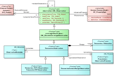
WaterML 2.0 TimeseriesObservation takes the second view of OM_Observation and defines TimeseriesObservation, TimeseriesTVPObservation and a TimeseriesDomainRangeObservation as shown in Figure 9.
The two subtypes of TimeseriesObservation offer two different structuring of the timeseries result: a time-value pair style structure where the time, value and associated metadata are encoded as coupled items (TimeseriesTVPObservation), and a separated structure where the time and values are represented as separate collections with metadata described separately to the time and values (TimeseriesDomainRangeObservation). The first style is most common within the hydrology domain; the second approach is common within communities that make use of coverages. The second approach will most often result in a more compact encoding due to a more efficient structuring. See section 9.12.2 for a detailed description of the relationship to coverages.
use without the TimeseriesObservation feature type; this would be useful, for example, where existing systems are communicating that have previously agreed upon identifiers and/or context that allows sufficient context for exchange to occur.
Figure 7 - Observation specialisation
The properties (attributes and associations) of the TimeseriesObservation are outlined in the following sections. This includes properties that are inherited from the base classes from O&M; the description of the use is adapted to the context of this profile, providing guidance on how they should be used in the context of hydrological observations.
9.4.1.1 observedProperty (OM_Observation)
This property is used to describe the phenomenon that is being observed, “…such as "temperature", "height", "colour", "material"” [ISO19156]. The definitions of such properties take the form of a controlled vocabulary, ontology or hierarchy of some form. Part 1 of WaterML2.0 does not define the available hydrological phenomena involved in exchange; it is envisaged that a governing body such as WMO or the OGC Hydro Domain Working Group will define and govern such vocabularies. This property should reference a code item that adequately describes the phenomenon. See the XML implementation for how this is done using XLink + phenomenonTime :TM_Object + resultTime :TM_Instant + validTime :TM_Period [0..1] + resultQuality :DQ_Element [0..*] + parameter :NamedValue [0..*]
«FeatureType»
+ memberName :LocalName + definition :CharacterString
It is recommended that the observed phenomena be separated from the physical medium that is being sampled – see the sampled medium property in section 9.4.1.8.3 – and the units used for measurement (see MeasurementTimeseries in section 9.15.3).
9.4.1.2 parameter (OM_Observation)
This allows for arbitrary named value pairs to be specified for the observation. This is an extensible mechanism for adding (typically event-specific) information that may not be captured directly in the schema. The use of this property is described in ISO19156.
9.4.1.3 phenomenonTime (OM_Observation)
This property describes the temporal extent of the time series that is result of this observation. A TM_Object allows for multiple temporal objects defined by GML. WaterML2.0 restricts this to be a time period, defining the start and end times of the time series.
9.4.1.4 resultTime (OM_Observation)
O&M defines result time as the “…the time when the result becomes available, typically when the procedure associated with the observation was completed.” With a time series result, this will depend on the procedure used for the observation. For automated sensors producing continuous measurements, this will most likely be the time of the end of last point in the time series. For algorithms, sensors and manual methods, this will be time when the result time series becomes available, for example, when an algorithm or model has completed. The resultTime should be associated with the procedure producing the time series rather than generation of the encoded document (e.g. generation through a web service). The generationDate (see section 9.23) of the holding collection document should be used in this case.
9.4.1.5 validTime (OM_Observation)
This describes the time period for which the results are intended to be used. This is important for simulations (especially forecasts) that may only be applicable within a given window of time (often a newer data product will be available that supersedes the ‘observation’).
9.4.1.6 resultQuality (OM_Observation)
This is used to describe the overall quality of a time series. Time series often require per point quality information, which is provided by the specific timeseries types that are used (defined in section 9.12).
9.4.1.7 featureOfInterest (OM_Observation)
The feature of interest describes the feature that is the target of the observation. ISO19156 makes the distinction between observations that make direct observations of feature properties and those that sample the feature and use the sample as a proxy for the value of a feature’s property (often this step involves process, e.g. using an aggregation or interpolation method). Within hydrology sampling is the most common approach (e.g. making a measurement at a particular point on a river section to make inferences about the whole river). Example spatial sampling features within the hydrology domain are shown in Table 3 along with the associated type from ISO19156. All these sampling types exist for the purpose of making estimates of properties (phenomena) of a larger body.
Table 3 - Mapping of hydrological sampling features
Hydrological term ISO19156 – Observations & Measurements
Monitoring station, gauging station, site SF_SamplingPoint
Borehole, observation well, river profile SF_SamplingCurve
River cross-section SF_SamplingSurface
This profile defines one specialised sampling feature, a MonitoringPoint, which describes the characteristics of an in-situ point of observation (e.g. a monitoring station). This feature is recommended when describing such observations but it is recognised that more sampling features exist, thus the restriction of this property only extends to SF_SpatialSamplingFeature.
The core of WaterML2.0 does not restrict the feature of interest to be only point-based sampling features. It does, however, identify that this is a common pattern for in-situ monitoring and captures this in the “monitoring point feature of interest” requirements class. It is thus possible to use different sampling features as the target feature. For example, the timeseries observation may describe the average value of a polygon through time.
A separate OGC Discussion paper (11-039r2 HY_Features a Common Hydrologic Feature Model) provides a model for hydrologic features of interest and domain features. If exchanging detailed information on hydrologic features is required, this provides a framework for exchanging hydrologic features. As most timeseries data sources utilize monitoring points, the addition of a simple monitoring point feature is suitable for data exchange of this style.
9.4.1.8 metadata (OM_Observation)
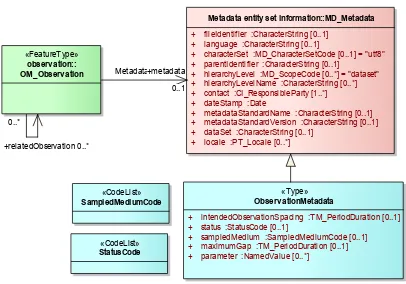
Figure 8 - Observation metadata
ObservationMetadata, defined as a specialisation of the ISO19115 MD_Metadata type, adds observation specific metadata; each property is described in the following sections.
9.4.1.8.1 intendedObservationSpacing
This defines the expected duration between individual observations. It is common that observations will occur frequently (such as those performed by automated sensors or regular visits); this property allows specification of expected time between measurements. This is reflected in the individual points that make up the resulting time series, but there are cases where the observation interval does not match the intended observation interval. One example would be an increased observation interval intended to capture an event such as a peak in flood. Note there is also the spacing property for Timeseries that is a stricter definition, allowing regularly spaced (equidistant) time series to be encoded (see section 9.12.3.1.2 for a full description).
9.4.1.8.2 status
The status is used as a general categorisation of the state of an observation often relating to the level of validation that has occurred to the data. This property will most likely reference a term in code list (e.g. ‘Validated’, ‘Provisional’). WaterML2.0 does not currently define a code list for the list of potential statuses. This will be addressed in future vocabulary work.
«Type»
Observ ationMetadata
+ intendedObservationSpacing :TM_PeriodDuration [0..1] + status :StatusCode [0..1]
+ sampledMedium :SampledMediumCode [0..1] + maximumGap :TM_PeriodDuration [0..1] + parameter :NamedValue [0..*]
Metadata entity set information::MD_Metadata
+ fileIdentifier :CharacterString [0..1] + language :CharacterString [0..1]
+ characterSet :MD_CharacterSetCode [0..1] = "utf8" + parentIdentifier :CharacterString [0..1]
+ hierarchyLevel :MD_ScopeCode [0..*] = "dataset" + hierarchyLevelName :CharacterString [0..*] + contact :CI_ResponsibleParty [1..*] + dateStamp :Date
+ metadataStandardName :CharacterString [0..1] + metadataStandardVersion :CharacterString [0..1] + dataSet :CharacterString [0..1]
9.4.1.8.3 sampledMedium
Describes the medium that was sampled in order to make the observation (e.g. water). Table 4 lists some of the commonly represented mediums in hydrological monitoring. Note: future work on vocabularies harmonisation will investigate hierarchical and mapping related vocabulary items (see section 9.3 for further discussion). The URIs listed provide an initial step towards interoperability of code items.
Table 4 - Media for hydrological monitoring
Medium OGC Name
Water http://www.opengis.net/def/waterml/2.0/medium/Water
Ground Water http://www.opengis.net/def/waterml/2.0/medium/GroundWater Surface Water http://www.opengis.net/def/waterml/2.0/medium/SurfaceWater Sediment http://www.opengis.net/def/waterml/2.0/medium/SedimentWater Pore Water http://www.opengis.net/def/waterml/2.0/medium/PoreWater Pore Air http://www.opengis.net/def/waterml/2.0/medium/PoreAir Soil http://www.opengis.net/def/waterml/2.0/medium/Soil Soil Air http://www.opengis.net/def/waterml/2.0/medium/SoilAir Soil Water http://www.opengis.net/def/waterml/2.0/medium/SoilWater Atmosphere http://www.opengis.net/def/waterml/2.0/medium/Atmosphere Tissue http://www.opengis.net/def/waterml/2.0/medium/Tissue Ground snow http://www.opengis.net/def/waterml/2.0/medium/GroundSnow Unknown http://www.opengs.net/def/nil/OGC/0/unknown
9.4.1.8.4 parameter
9.4.1.8.5 maximumGap
Maximum gap provides information on the joining of different observations into a larger series. See section 9.15.2.2 for more information.
9.5 Time series observation specialisations
The core TimeseriesObservation is restricted in two specialised types that represent the two possible timeseries result structures: domain-range and time-value pairs. See section 9.12 for details on the definition of the timeseries types.
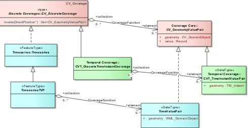
Note: The TimeseriesObservation does not directly subclass the OM_TimeseriesObservation from ISO19156 as this type restricts the result to a CVT_DiscreteTimeInstantCoverage, which is a style of TVP timeseries and thus would not allow the domain-range style of timeseries. Future work will attempt to harmonise the definition of timeseries across the ISO/OGC standards. Figure 10 shows the relationship between the time-value pair structuring of timeseries with the CVT_DiscreteTimeInstantCoverage type. The WaterML2.0 TimeValuePair type makes the specialisation of the DomainObject (to a temporal component) explicit through the WML_DomainObject.
The two types reflect different styles of representing timeseries observations.
Figure 9 - Observation types as related to ISO19156 (green) and ISO19123 (red)
Figure 10 - Relationship to CVT_TimeInstantCoverage (ISO19156 – Annex C, green)
9.6 Requirements class – Timeseries (domain range) Observation
Requirements Class
http://www.opengis.net/spec/waterml/2.0/req/uml-timeseries-domain-range-observation
Target Type Encoding of the conceptual model Name Time series (domain range) observation
Dependency http://www.opengis.net/spec/waterml/2.0/req/uml-timeseries-observation
Dependency http://www.opengis.net/spec/waterml/2.0/req/uml-timeseries-domain-range
Requirement /req/uml-timeseries-domain-range-observation/result
A TimeseriesDomainRangeObservation shall have a result of type
TimeseriesDomainRange, as defined in section 9.13 of this standard. This is represented in the UML in Figure 9.
9.6.1.1 result (OM_Observation)
The result of a TimeseriesDomainRangeObservation is restricted to be of type TimeseriesDomainRange as defined in section 9.13.
«DataType» TimeValuePair
+ geometry :WML_DomainObject
«FeatureType»
+ geometry :TM_Instant CV_Coverage
«type»
Discrete Coverages::CV_DiscreteCoverage
+ locate(DirectPosition*) :Set<CV_GeometryValuePair>
Cov erage Core:: CV_GeometryValuePair
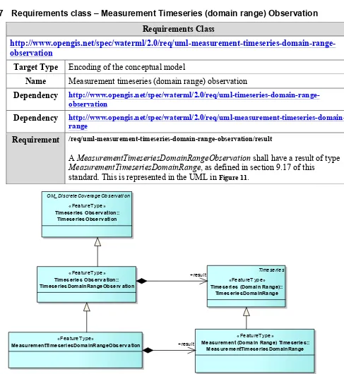
9.7 Requirements class – Measurement Timeseries (domain range) Observation
Requirements Class
http://www.opengis.net/spec/waterml/2.0/req/uml-measurement-timeseries-domain-range-observation
Target Type Encoding of the conceptual model
Name Measurement timeseries (domain range) observation
Dependency http://www.opengis.net/spec/waterml/2.0/req/uml-timeseries-domain-range-observation
Dependency http://www.opengis.net/spec/waterml/2.0/req/uml-measurement-timeseries-domain-range
Requirement /req/uml-measurement-timeseries-domain-range-observation/result
A MeasurementTimeseriesDomainRangeObservation shall have a result of type MeasurementTimeseriesDomainRange, as defined in section 9.17 of this
standard. This is represented in the UML in Figure 11.
Figure 11 - Measurement timeseries (domain range) observation
9.7.1.1 result (OM_Observation)
The result of a MeasurementTimeseriesDomainRangeObservation is restricted to be of type MeasurementTimeseriesDomainRange as defined in section 9.17.
OM_DiscreteCoverageObservation
«FeatureType» Timeseries Observ ation::
TimeseriesObserv ation
«FeatureType» Timeseries Observ ation:: TimeseriesDomainRangeObserv ation
Timeseries
«FeatureType» Timeseries (Domain Range)::
TimeseriesDomainRange
«FeatureType»
MeasurementTimeseriesDomainRangeObserv ation
«FeatureType»
Measurement (Domain Range) Timeseries:: MeasurementTimeseriesDomainRange +result
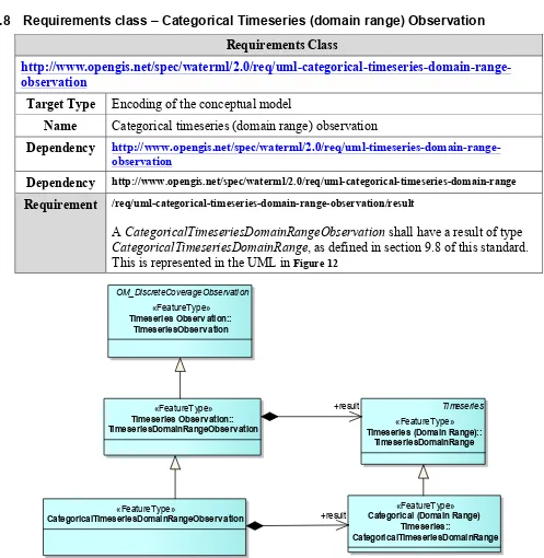
9.8 Requirements class – Categorical Timeseries (domain range) Observation
Requirements Class
http://www.opengis.net/spec/waterml/2.0/req/uml-categorical-timeseries-domain-range-observation
Target Type Encoding of the conceptual model
Name Categorical timeseries (domain range) observation
Dependency http://www.opengis.net/spec/waterml/2.0/req/uml-timeseries-domain-range-observation
Dependency http://www.opengis.net/spec/waterml/2.0/req/uml-categorical-timeseries-domain-range
Requirement /req/uml-categorical-timeseries-domain-range-observation/result
A CategoricalTimeseriesDomainRangeObservation shall have a result of type CategoricalTimeseriesDomainRange, as defined in section 9.8 of this standard. This is represented in the UML in Figure 12
Figure 12 - categorical timeseries (domain range) observation
9.8.1.1 result (OM_Observation)
The result of a CategoricalTimeseriesDomainRangeObservation is restricted to be of type CategoricalTimeseriesDomainRange as defined in section 9.18.
OM_DiscreteCoverageObservation
«FeatureType» Timeseries Observ ation::
TimeseriesObserv ation
«FeatureType» Timeseries Observ ation:: TimeseriesDomainRangeObserv ation
Timeseries
«FeatureType» Timeseries (Domain Range)::
TimeseriesDomainRange
«FeatureType»
CategoricalTimeseriesDomainRangeObserv ation
«FeatureType» Categorical (Domain Range)
Timeseries::
CategoricalTimeseriesDomainRange +result
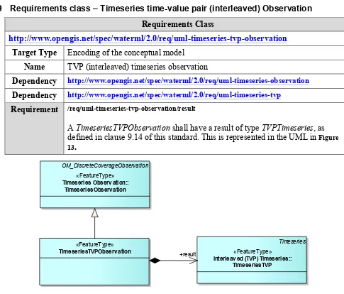
9.9 Requirements class – Timeseries time-value pair (interleaved) Observation
Requirements Class
http://www.opengis.net/spec/waterml/2.0/req/uml-timeseries-tvp-observation
Target Type Encoding of the conceptual model Name TVP (interleaved) timeseries observation
Dependency http://www.opengis.net/spec/waterml/2.0/req/uml-timeseries-observation
Dependency http://www.opengis.net/spec/waterml/2.0/req/uml-timeseries-tvp
Requirement /req/uml-timeseries-tvp-observation/result
A TimeseriesTVPObservation shall have a result of type TVPTimeseries, as defined in clause 9.14 of this standard. This is represented in the UML in Figure 13.
Figure 13 - Timeseries (TVP) Observation
9.9.1.1 result (OM_Observation)
The result of a TVPTimeseriesObservation is restricted to be of type TVPTimeseries as defined in section 9.14.
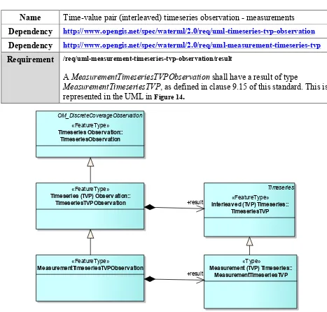
9.10 Requirements class – Measurement Timeseries time-value pair (interleaved) Observation
Requirements Class
http://www.opengis.net/spec/waterml/2.0/req/uml-measurement-timeseries-tvp-observation
Target Type Encoding of the conceptual model
«FeatureType» TimeseriesTVPObserv ation
OM_DiscreteCoverageObservation
«FeatureType» Timeseries Observ ation::
TimeseriesObserv ation
Timeseries
«FeatureType» Interleav ed (TVP) Timeseries::
Name Time-value pair (interleaved) timeseries observation - measurements Dependency http://www.opengis.net/spec/waterml/2.0/req/uml-timeseries-tvp-observation
Dependency http://www.opengis.net/spec/waterml/2.0/req/uml-measurement-timeseries-tvp
Requirement /req/uml-measurement-timeseries-tvp-observation/result
A MeasurementTimeseriesTVPObservation shall have a result of type
MeasurementTimeseriesTVP, as defined in clause 9.15 of this standard. This is represented in the UML in Figure 14.
Figure 14 - Measurement timeseries (TVP) Observation
9.10.1.1 result (OM_Observation)
The result of a MeasurementTimeseriesTVPObservation is restricted to be of type MeasurementTimeseriesTVP as defined in section 9.15.
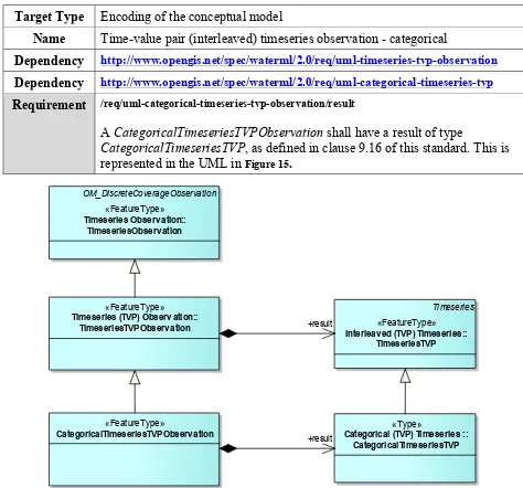
9.11 Requirements class – Categorical Timeseries time-value pair (interleaved) Observation
Requirements Class
«FeatureType»
Timeseries (TVP) Observ ation:: TimeseriesTVPObserv ation
OM_DiscreteCoverageObservation
«FeatureType»
Timeseries Observ ation:: TimeseriesObserv ation
Timeseries
«FeatureType»
Interleav ed (TVP) Timeseries:: TimeseriesTVP
«FeatureType»
MeasurementTimeseriesTVPObserv ation
«Type»
Measurement (TVP) Timeseries:: MeasurementTimeseriesTVP
+result
Target Type Encoding of the conceptual model
Name Time-value pair (interleaved) timeseries observation - categorical
Dependency http://www.opengis.net/spec/waterml/2.0/req/uml-timeseries-tvp-observation
Dependency http://www.opengis.net/spec/waterml/2.0/req/uml-categorical-timeseries-tvp
Requirement /req/uml-categorical-timeseries-tvp-observation/result
A CategoricalTimeseriesTVPObservation shall have a result of type
CategoricalTimeseriesTVP, as defined in clause 9.16 of this standard. This is represented in the UML in Figure 15.
Figure 15 - Categorical timeseries (TVP) Observation
9.11.1.1 result (OM_Observation)
The result of a CategoricalTVPTimeseriesObservation is restricted to be of type CategoricalTimeseriesTVP as defined in clause 9.16.
9.12 Requirements class: Timeseries (Core)
Requirements Class
http://www.opengis.net/spec/waterml/2.0/req/uml-timeseries-core
«FeatureType» Timeseries (TVP) Observ ation::
TimeseriesTVPObserv ation OM_DiscreteCoverageObservation
«FeatureType» Timeseries Observ ation::
TimeseriesObserv ation
Timeseries
«FeatureType» Interleav ed (TVP) Timeseries::
TimeseriesTVP
«FeatureType»
CategoricalTimeseriesTVPObserv ation
«Type»
Categorical (TVP) Timeseries :: CategoricalTimeseriesTVP +result
Target Type Encoding of the conceptual model Name Timeseries
Dependency urn:iso:dis:iso:19123:clause:5.3 (CV_Coverage)
Requirement /req/uml-timeseries-core/domain-object
A timeseries is a coverage whose domain shall consist of the temporal elements of the timeseries. If the series is spatially varying, the spatial elements shall describe each spatial element (empty for in-situ timeseries). This is shown in
Figure 18.
Requirement /req/uml-timeseries-core/time-increasing
The time elements of the timeseries shall be ordered in increasing time. Requirement /req/uml-timeseries-core/record-homogenous
The record-type for the values (range) of the timeseries shall be homogenous. Requirement /req/uml-timeseries-core/coverage-type
A timeseries shall implement the domain-range or geometry-value (time-value pairs) coverage type. (This requirements class is abstract).
Requirement /req/uml-timeseries-core/quality
When specifying the quality of a data point using the quality property (section 9.12.3.2.1) an appropriate URI from Table 5 shall be used.
Requirement /req/uml-timeseries-core/timeseries-metadata
The timeseries shall support metadata for the series as shown in the UML in
Figure 16 and Figure 19.
Requirement /req/uml-timeseries-core/point-metadata