1
Open Geospatial Consortium
Submission Date: 2015-09-15 Approval Date: 2015-09-17 Publication Date: 2015-12-09 External identifier of this OGC® document: http://www.opengis.net/doc/dp/om-json/
Internal reference number of this OGC® document: 15-100r1 Category: OGC® Discussion Paper Editors: Simon J D Cox, Peter Taylor
OGC Observations and Measurements – JSON
implementation
Copyright notice
Copyright © 2015 Open Geospatial Consortium
To obtain additional rights of use, visit http://www.opengeospatial.org/legal/.
Warning
This document is not an OGC Standard. This document is an OGC Discussion Paper and is therefore not an official position of the OGC membership. This document is distributed for review and comment. It is subject to change without notice and may not be referred to as an OGC Standard. Further, an OGC Discussion Paper should not be referenced as required or mandatory technology in procurements.
Document type: OGC® Discussion Paper Document subtype: Not applicable
Copyright © 2015 Open Geospatial Consortium 2 License Agreement
Permission is hereby granted by the Open Geospatial Consortium, ("Licensor"), free of charge and subject to the terms set forth below, to any person obtaining a copy of this Intellectual Property and any associated documentation, to deal in the Intellectual Property without restriction (except as set forth below), including without limitation the rights to implement, use, copy, modify, merge, publish, distribute, and/or sublicense copies of the Intellectual Property, and to permit persons to whom the Intellectual Property is furnished to do so, provided that all copyright notices on the intellectual property are retained intact and that each person to whom the Intellectual Property is furnished agrees to the terms of this Agreement.
If you modify the Intellectual Property, all copies of the modified Intellectual Property must include, in addition to the above copyright notice, a notice that the Intellectual Property includes modifications that have not been approved or adopted by LICENSOR.
THIS LICENSE IS A COPYRIGHT LICENSE ONLY, AND DOES NOT CONVEY ANY RIGHTS UNDER ANY PATENTS THAT MAY BE IN FORCE ANYWHERE IN THE WORLD.
THE INTELLECTUAL PROPERTY IS PROVIDED "AS IS", WITHOUT WARRANTY OF ANY KIND, EXPRESS OR IMPLIED, INCLUDING BUT NOT LIMITED TO THE WARRANTIES OF MERCHANTABILITY, FITNESS FOR A PARTICULAR PURPOSE, AND NONINFRINGEMENT OF THIRD PARTY RIGHTS. THE COPYRIGHT HOLDER OR HOLDERS INCLUDED IN THIS NOTICE DO NOT WARRANT THAT THE FUNCTIONS CONTAINED IN THE INTELLECTUAL PROPERTY WILL MEET YOUR REQUIREMENTS OR THAT THE OPERATION OF THE INTELLECTUAL PROPERTY WILL BE
UNINTERRUPTED OR ERROR FREE. ANY USE OF THE INTELLECTUAL PROPERTY SHALL BE MADE ENTIRELY AT THE USER’S OWN RISK. IN NO EVENT SHALL THE COPYRIGHT HOLDER OR ANY CONTRIBUTOR OF
Copyright © 2015 Open Geospatial Consortium 3
Contents
1. Scope ... 7
2. Conformance ... 7
2.1 Overview ... 7
2.2 Conformance classes ... 7
3. Normative references ... 9
4. Terms and Definitions ... 10
5. Conventions ... 10
5.1 Abbreviated terms ... 10
5.2 Schema language ... 11
5.3 Layout and identifiers ... 11
6. Overview ... 12
6.1 Use of JSON ... 12
6.2 Conformance with O&M model ... 13
7. Requirements for JSON encoded instances of Observations ... 15
7.1 Introduction ... 15
7.2 Requirements class: JSON base types ... 16
7.3 Requirements class: Geometry types ... 19
7.4 Requirements class: Time Series time-value-pair encoding ... 20
7.5 Requirements class: Sampling feature data ... 25
7.6 Requirements class: Specimen data ... 26
7.7 Requirements class: Spatial sampling feature data ... 28
7.8 Requirements class: Sampling feature collection ... 29
7.9 Requirements class: Observation data ... 31
7.10 Requirements class: collections of observations ... 34
Copyright © 2015 Open Geospatial Consortium 4
A.1 Introduction ... 37
A.2 Conformance class: base types ... 38
A.3 Conformance class: geometry ... 39
A.4 Conformance class: time series ... 40
A.5 Conformance class: sampling features ... 40
A.6 Conformance class: specimen features ... 41
A.7 Conformance class: spatial sampling features ... 41
A.8 Conformance class: sampling feature collection ... 42
A.9 Conformance class: observations ... 43
Copyright © 2015 Open Geospatial Consortium 5
i.Abstract
This Discussion Paper specifies a potential OGC Candidate Standard for a JSON
implementation of the OGC and ISO Observations and Measurements (O&M) conceptual model (OGC Observations and Measurements v2.0 also published as ISO/DIS 19156). This encoding is expected to be useful in RESTful implementations of observation services.
More specifically, this Discussion Paper defines JSON schemas for observations, and for features involved in sampling when making observations. These provide document models for the exchange of information describing observation acts and their results, both within and between different scientific and technical communities.
ii.Keywords
The following are keywords to be used by search engines and document catalogues. ogcdoc, ogc documents, O&M, observations, measurements, sampling, RESTful API, JSON encoding
iii.Preface
The OGC Observations and Measurements JSON standard defines a new implementation of O&M compatible with current expectations for web data delivery, in particular REST APIs.
Attention is drawn to the possibility that some of the elements of this document may be the subject of patent rights. The Open Geospatial Consortium shall not be held
responsible for identifying any or all such patent rights.
Recipients of this document are requested to submit, with their comments, notification of any relevant patent claims or other intellectual property rights of which they may be aware that might be infringed by any implementation of the standard set forth in this document, and to provide supporting documentation.
iv.Submitting organizations
The following organizations submitted this Document to the Open Geospatial Consortium (OGC):
CSIRO Australia
v.Submitters
All questions regarding this submission should be directed to the editor or the submitters:
Name Affiliation
Simon J D Cox CSIRO
Copyright © 2015 Open Geospatial Consortium 6
vi.Changes to the OGC® Abstract Specification
The encoding described in this Discussion Paper uses a property samplingStrategy for observations to link to sampling features independently of the featureOfInterest property, which should be used strictly for a feature with which the observed property is associated. This encoding includes an Observation Collection class, to enable common properties of a collection of observations to be (optionally) associated with a container object, instead of repeated on every member observation.
This encoding adds some properties of individual sampling features to the Sampling Feature Collection class, to enable common properties of a collection of sampling
features to be (optionally) associated with a container object, instead of repeated on every member sampling feature.
This encoding adds an optional property samplingElevation to the description of
Specimens, to support a common use-case where the vertical offset from a 2-D location needs to be specified.
Changes to the UML model in OGC® Abstract Specification – Topic 20 should be considered to match these.
vii.Future work
Copyright © 2015 Open Geospatial Consortium 7
1.
Scope
This Discussion Paper defines a JSON implementation of schemas for observations, and for features involved in sampling when making observations. This provides document models for the exchange of information describing observation acts and their results, both within and between different scientific and technical communities.
The implementation is derived from a conceptual model defined in OGC Observations and Measurements v2.0 (also published as ISO/DIS 19156) with some modifications to support a more streamlined encoding of collections, and to improve the handling of sampling strategies. The conversion to JSON was done manually, but provides a data-point for potential standardization of a modelàJSON conversion rule.
This document does not describe the full O&M information models or XML/GML encodings. The OGC/ISO standards (above) should be referred to for these details.
2.
Conformance
2.1 Overview
The proposed standard described in this Discussion Paper defines seven requirements classes, covering the most commonly used Observation types (generic observation, measurement, category observation, count observation, truth observation, geometry observation, temporal observation, time-series observation) and all sampling feature types specified in Topic 20 except sampling solid.
Requirements for one standardization target type is considered:
instances of observation data encoded in JSON
Since data producing applications should generate conformant data instances, the
requirements and tests described in this standard also apply to this standardization target.
NOTE: Requirements and tests for a second standardization target type (data consuming applications, i.e. data processing software that accepts observation data as input) are also highly desirable. However, a general solution to specifying this target this is more challenging and has been deferred.
2.2 Conformance classes
The framework, concepts, and methodology for testing, and the criteria to be achieved to claim conformance are specified in the OGC Compliance Testing Policies and Procedures and the OGC Compliance Testing web site1.
Annex A defines a set of tests and conformance classes that will support various applications with a range of different requirements. Seven conformance classes are
Copyright © 2015 Open Geospatial Consortium 8
Copyright © 2015 Open Geospatial Consortium 9
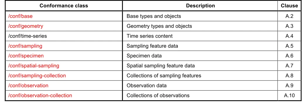
Table 1 — Conformance classes related Observations and Measurements instances
Conformance class Description Clause
/conf/base Base types and objects A.2
/conf/geometry Geometry types and objects A.3
/conf/time-series Time series content A.4
/conf/sampling Sampling feature data A.5
/conf/specimen Specimen data A.6
/conf/spatial-sampling Spatial sampling feature data A.7
/conf/sampling-collection Collections of sampling features A.8
/conf/observation Observation data A.9
/conf/observation-collection Collections of observations A.10
3.
Normative references
The following normative documents contain provisions that, through reference in this text, constitute provisions of this document. For dated references, subsequent amendments to, or revisions of, any of these publications do not apply. For undated references, the latest edition of the normative document referred to applies.
ECMA-404, The JSON Data Interchange Format, (2013) 7pp.
http://www.ecma-international.org/publications/files/ECMA-ST/ECMA-404.pdf (accessed August 19, 2015). F. Galiegue, K. Zyp, G. Court, eds., JSON Schema: core definitions and terminology, (2013) 14pp.
https://tools.ietf.org/html/draft-zyp-json-schema-04 (accessed August 21, 2015).
ISO 8601- Data elements and interchange formats – Information interchange – Representation of dates and times
OGC 08-131r3, The Specification Model — A Standard for Modular specifications, (2008). https://portal.opengeospatial.org/files/34762 (accessed August 21, 2015).
OGC Abstract Specification Topic 20 – OGC Observations and Measurements v2.0 OGC Document 10-004r1 http://www.opengis.net/doc/AS/Topic20 (also published as ISO/DIS 19156:2010, Geographic information — Observations and Measurements)
OGC Sensor Observation Service (SOS) v2.0 - OGC Document 12-006.
http://www.opengis.net/doc/IS/SOS/2.0.
Copyright © 2015 Open Geospatial Consortium 10
4.
Terms and Definitions
This document uses the terms defined in Sub-clause 5.3 of [OGC 06-121r8], which is based on the ISO/IEC Directives, Part 2, Rules for the structure and drafting of International Standards. In particular, the word “shall” (not “must”) is the verb form used to indicate a requirement to be strictly followed to conform to this standard.
For the purposes of this document, the following additional terms and definitions apply.
4.1
GeoJSON
a geospatial data interchange format based on JavaScript Object Notation (JSON)
4.2
JSON
a lightweight, text-based, language-independent data interchange format, based on the Javascript programming language
4.3
JSON Schema
JSON document to describe a JSON data structure, providing for documentation and structural validation
5.
Conventions
5.1 Abbreviated terms
JSON Javascript Object Notation O&M Observations and Measurements
OM-JSON Observations and Measurements JSON Implementation OMXML Observations and Measurements XML Implementation OGC Open Geospatial Consortium
SOS Sensor Observation Service SWE Sensor Web Enablement UML Unified Modeling Language
Copyright © 2015 Open Geospatial Consortium 11 5.2 Schema language
The JSON implementation specified in this draft standard is described using JSON Schema2. Version 4 of JSON Schema supports composition of a schema from elements defined in multiple documents, which we take advantage of here.
5.3 Layout and identifiers
This standard follows the structures defined in the OGC Policy [The Specification Model – A Standard for Modular specifications]. All normative material is organized as requirements, requirements classes, conformance tests and conformance classes. Each is identified with a URI, and the content and dependencies are described in tables whose structure matches the specification model.
The normative provisions for OM-JSON are denoted by the URI http://www.opengis.net/spec/om-json/1.0. All requirements and conformance tests that appear in this document are denoted by relative URIs which are relative to this base URI.
Copyright © 2015 Open Geospatial Consortium 12
6.
Overview
This draft standard contains requirements relating to a single standardization target: data documents. Specifically these are documents containing observation data conforming to the O&M model and encoded in JSON.
This is a draft implementation standard based on OGC Observations and Measurements (OGC Abstract Specification – Topic 20), complementing OMXML (OGC 10-025r1) which provides a GML-based XML encoding. OWL implementations have also been proposed [Cox 2013, 2015].
This draft standard provides a JSON encoding of O&M that is independent of a web service or API. This allows a common encoding to be used across services, leading to increased interoperability. JSON encodings of O&M have been specified in some existing services, including:
1. The Sensor Observation Service (SOS) implementation from 52North provides a JSON encoding, also described using JSON Schema3.
2. The candidate OGC standard, SensorThings API, has a component that handles JSON encoding of observations.4
3. A CSIRO developed ‘SensorCloud’ has a partial implementation of an O&M JSON encoding. A partial review of these has occurred; further harmonization is recommended.
6.1 Use of JSON
There is currently no formalised UML to JSON mapping rule for the GML UML profile. The engineering report “OWS-9: UML-to-GML-Application Schema (UGAS) Conversion Engineering Report”
investigates some approaches. The ShapeChange tool5 implements the rules outlined in the OWS-9 report. This tool was used within the WaterML2.0 part 2 Interoperability Experiment to generate JSON Schema, with some minor modifications6.
The “Testbed 11 Implementing JSON/GeoJSON in an OGC Standard” provides recommendations for the use of JSON, JSON-LD and GeoJSON in OGC standards.
The schema follows a set of UML to JSON encoding rule as follows:
An instance of a class is a JSON object. The value of a name/value pair with the name ‘type’7 maps to the UML class name.
3 https://github.com/52North/SOS/tree/master/coding/json-common/src/main/resources/schema 4 http://ogc-iot.github.io/ogc-iot-api/
5
http://shapechange.net/targets/json/ 6
https://portal.opengeospatial.org/files/?artifact_id=61224
Copyright © 2015 Open Geospatial Consortium 13 Properties (attributes and association roles) are name/value pairs. The ‘name’ matches the UML
attribute name or association role name
Cardinality/obligation of properties are generally relaxed compared to the abstract/conceptual model. While values for all mandatory properties are required to be available, in some cases they are recorded against a container class (collection) rather than the atomic object.
Values are JSON objects, except where the type corresponds with one of the built-in JSON types.
A set of basic object types required for OM-JSON is described in the /req/base requirements class, and defined rigorously in the Common.json and Temporal.json JSON-Schema documents.
GeoJSON geometry encoding is used, and defined in a JSON-Schema for geometry.
JSON does not have a formal class model - JSON Objects are just sets of properties. However, similar to GeoJSON, the JSON encoding described in this draft standard features a “type” property on each JSON object, to support explicit alignment with the underlying conceptual model. The value of this type is matched to O&M v2.0 class names is provided in Table 2.
Table 2 — Map of UML class names from O&M v2.0 to values for the type property in OM-JSON
Class in O&M v2.0 Type in OM-JSON Class in O&M v2.0 Type in OM-JSON
OM_Observation Observation SF_SamplingFeature SamplingFeature
OM_Measurement Measurement SF_Specimen Specimen
OM_CategoryObservation CategoryObservation SF_SpatialSamplingFeature SpatialSamplingFeature
OM_CountObservation CountObservation SF_SamplingPoint SamplingPoint
OM_TruthObservation TruthObservation SF_SamplingCurve SamplingCurve
OM_GeometryObservation GeometryObservation SF_SamplingSurface SamplingSurface
OM_TemporalObservation TemporalObservation SF_SamplingSolid Not implemented
OM_TimeSeriesObservation TimeSeriesObservation
6.2 Conformance with O&M model
Copyright © 2015 Open Geospatial Consortium 14
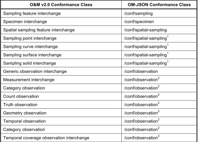
Table 3 —Map of O&M v2.0 Conformance Classes to OM-JSON.
O&M v2.0 Conformance Class OM-JSON Conformance Class
Sampling feature interchange /conf/sampling
Specimen interchange /conf/specimen
Spatial sampling feature interchange /conf/spatial-sampling
Sampling point interchange /conf/spatial-sampling1
Sampling curve interchange /conf/spatial-sampling1
Sampling surface interchange /conf/spatial-sampling1
Sampling solid interchange /conf/spatial-sampling1
Generic observation interchange /conf/observation
Measurement interchange /conf/observation2
Category observation /conf/observation2
Count observation /conf/observation2
Truth observation /conf/observation2
Geometry observation /conf/observation2
Temporal observation /conf/observation2
Category observation /conf/observation2
Temporal coverage observation interchange /conf/observation2
1
The value of the “type” property, and the type of the “shape” property determine the spatial sampling feature type
2
15
Copyright © 2015 Open Geospatial Consortium
7.
Requirements for JSON encoded instances of Observations
7.1 Introduction
An Observations and Measurements data document will include one or more of the JSON objects listed in Table 2. The basic requirements for data instances are, therefore,
formalized in terms of these elements. The corresponding conformance tests use document validation using various combinations of schema documents.
Nine requirements classes are described in this clause. Figure 1 provides a graphical (informative) summary of the dependencies of the requirements classes.
16
Copyright © 2015 Open Geospatial Consortium 7.2 Requirements class: JSON base types
This requirements class defines the base requirements for JSON encodings. It includes definitions of common types used in a number of applications.
NOTE: The JSON objects defined in this requirements class are not specific to Observations and Measurements applications. This requirements class may be suitable for use in JSON encodings for other geospatial applications.
Requirements Class
/req/base
Target type Data instance Dependency JSON
Dependency GeoJSON
Dependency XML Schema – Part 2
Requirement /req/base/json
Requirement /req/base/time-position
Requirement /req/base/time-instant
Requirement /req/base/time-interval
Requirement /req/base/duration
Requirement /req/base/measure
Requirement /req/base/vocab-term
Requirement /req/base/link
The first requirement is that an OM-JSON document is a valid JSON document.
Requirement /req/base/json
A data instance shall be a conformant JSON document, as defined in ECMA-404
JSON has a limited range of built-in types (http://json.org/ ). The next seven requirements provide standard JSON representations of additional types required across all
requirements within this specification.
ISO 8601 defines a standard 7-element encoding for time position expressed as a date in the Gregorian calendar and time on the 24-hour clock with timezone. A number of sub-types from ISO 8601 are described in W3C XML-Schema – Part 2 – Datasub-types, which provides both an accessible definition and convenient identifiers for the individual types. Temporal position is encoded as a text string matching a subset of the relevant XML Schema types.
Requirement /req/base/time-position
17
Copyright © 2015 Open Geospatial Consortium character string matching one of the following XML Schema types:
http://www.w3.org/TR/xmlschema11-2/#dateTime
http://www.w3.org/TR/xmlschema11-2/#date
http://www.w3.org/TR/xmlschema11-2/#gYearMonth
http://www.w3.org/TR/xmlschema11-2/#gYear. Examples:
“2015-05-12T15:05:00.00+10:00” “2015-05-12T05:05:00.00Z” “2015-05-12”
“2015-05” “2015”
A time instant is encoded as a JSON object with a single property whose value is a temporal position.
Requirement /req/base/time-instant
Each date-time position used in a data instance shall be encoded as a JSON object with a single property “instant” whose value is a temporal position.
Examples:
{ “instant”: “2015-05-12T15:05:00.00+10:00” }
{ “instant”: “2015-05-12T05:05:00.00Z” }
{ “instant”: “2015-05-12” }
{ “instant”: “2015-05” }
{ “instant”: “2015” }
A time interval is encoded as a JSON object with explicit ends.
Requirement /req/base/time-interval
Each date-time interval used in a data instance shall be encoded as a JSON object, with properties “begin” and “end”, whose value is a temporal position. An open-ended interval (i.e. in which an end is not specified) shall use the same JSON object, omitting the open end. Examples:
18
Copyright © 2015 Open Geospatial Consortium
{ “begin”: “1788-01-26” }
{ “end”: “1918-11-11” }
A time duration is encoded as a text string matching the relevant XML Schema type, or as a measure.
Requirement /req/base/duration
Each temporal duration used in a data instance shall be encoded either as a text string matching the XML Schema type
http://www.w3.org/TR/xmlschema11-2/#duration, or as a measure object, encoded following /req/base/measure
Examples:
“P1Y3M16DT2H35M14.53S”
{
“value”: 60, “uom”: “s” }
A quantity value or measure is encoded as a JSON object with properties for the value and unit of measure.
Requirement /req/base/measure
A measure value (scaled number or quantity) used in a data instance shall be encoded as a JSON object containing an amount, denoted “value”, and an optional unit of measure, denoted “uom”.If present, the value of “uom” shall be a symbol from UCUM, or a URI denoting a unit-of-measure defined in a web resource.
Examples:
{
“value”: 76.50 , “uom”: “kg” }
{
“value”: 4.567 ,
“uom”: “http://www.opengis.net/def/uom/ogc/0/My” }
A value from a controlled vocabulary encoded as a JSON object with properties for the term and vocabulary.
Requirement /req/base/vocab-term
19
Copyright © 2015 Open Geospatial Consortium object containing the text value in a property “term”, and an optional source vocabulary in a property “vocabulary”.If present, the value of “vocabulary” shall be a URI denoting a controlled vocabulary. Example:
{
“term”: “Geochemistry” ,
“vocabulary”: “http://ns.nature.com/subjects/” }
A link object is provided for reference to an external web resource
Requirement /req/base/link
A hyperlink used in a data instance shall be encoded as a JSON object, with a property “href” carrying the URI of the external resource, an optional “rel” property providing the semantics of the reference, and an optional “title” property providing a human readable label for the reference.
Example:
{
“title”: “OGC Observations and Measurements”,
“href”: “http://www.opengeospatial.org/standards/om”, “rel”: “http://www.opengis.net/def/doc-type/as” }
The vocab-term object is particularly useful where a vocabulary is published as a whole, but without separate URIs for each member. On the other hand some vocabularies are published with a URI for each vocabulary item, in which case a link object could be used instead of a vocab-term.
7.3 Requirements class: Geometry types
This requirements class defines the requirements for JSON encoding of geometry.
Requirements Class
/req/geometry
Target type Data instance Dependency JSON
Dependency GeoJSON
Dependency XML Schema – Part 2
Requirement /req/geometry/geojson
The encoding of geometry follows GeoJSON for Position, Point, MultiPoint, LineString, MultiLineString, Polygon, MultiPolygon, Geometry Collection.
20
Copyright © 2015 Open Geospatial Consortium Objects in a data instance that describe 0-D, 1-D, or 2-D geometries with positions in the WGS84 system shall be encoded using the GeoJSON geometry encoding.
NOTE: GeoJSON supports 0-D, 1-D and 2-D geometries and collections, in a single Coordinate Reference System (CRS). If it is required to describe a geometry that falls outside the scope of GeoJSON, then another encoding must be used.
Examples:
"type": "LineString", "coordinates": [
7.4 Requirements class: Time Series time-value-pair encoding
This requirements class defines a JSON encoding for time-series, organized as a sequence of time-value-pairs. The encoding is based on the current version of
TimeseriesML, which is a draft OGC standard. This encoding should be updated when an endorsed standard is available. Time-series may be defined as a separate encoding
specification.
Requirements Class
/req/time-series
Target type Data instance Dependency /req/base
Requirement /req/time-series/series
Requirement /req/time-series/metadata
Requirement /req/time-series/tvp
Requirement /req/time-series/tvp-metadata
21
Copyright © 2015 Open Geospatial Consortium
Requirement /req/time-series/tvp-series
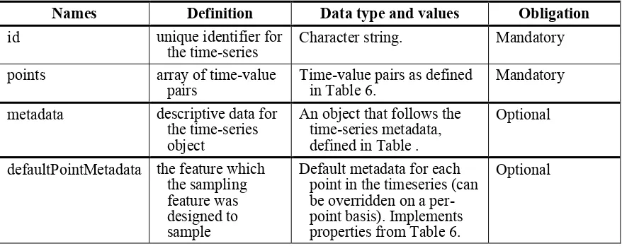
The time-series shall implement the properties shown in Table 4.
Table 4 - time-value-pair time-series properties
Names Definition Data type and values Obligation
id unique identifier for the time-series
Character string. Mandatory
points array of time-value pairs
Time-value pairs as defined in Table 6.
Mandatory
metadata descriptive data for the time-series object
An object that follows the time-series metadata, defined in Table .
Optional
defaultPointMetadata the feature which the sampling feature was designed to sample
Default metadata for each point in the timeseries (can be overridden on a per-point basis). Implements properties from Table 6.
Optional
Example:
{
"metadata": {
"intendedObservationSpacing": "P1D",
"status": {
"term”: "checked",
"vocabulary”: "http://www.example.org/vocabs"
}
},
"defaultPointMetadata": {
"interpolationType": {
"term”: "Continuous",
"vocabulary”: "http://www.opengis.net/def/waterml/2.0/interpolationType"
},
"quality": {
"term”: "good",
"vocabulary”: "http://www.opengis.net/def/waterml/2.0/quality"
},
"uom”: "http://www.qudt.org/qudt/owl/1.0.0/unit/Instances.html#Meter"
22
Copyright © 2015 Open Geospatial Consortium
}
]
}
Requirement /req/time-series/metadata
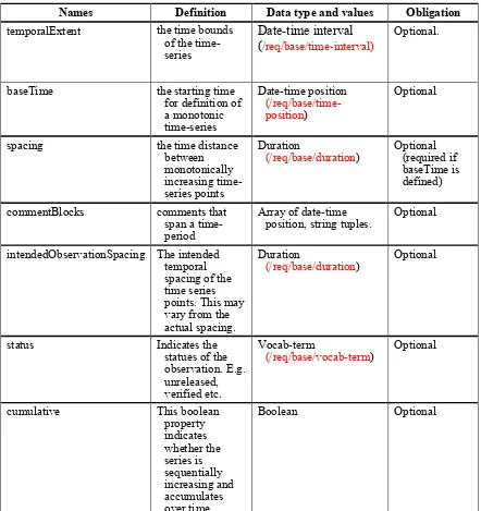
The time-series metadata type shall implement the properties shown in Table 5.
Table 5 - time-series metadata
Names Definition Data type and values Obligation
temporalExtent the time bounds of the
time-baseTime the starting time for definition of a monotonic
spacing the time distance
between
commentBlocks comments that span a time-period
Array of date-time position, string tuples.
Optional
intendedObservationSpacing The intended temporal spacing of the time series points. This may vary from the actual spacing.
Duration
(/req/base/duration)
Optional
status Indicates the
statues of the observation. E.g.
cumulative This boolean
property
23
Copyright © 2015 Open Geospatial Consortium
Names Definition Data type and values Obligation
accumulationAnchorTime Defines the time at which
startAnchorPoint Specifies a ‘ghost’ point to allow the first value of the time-series to be interpolated
endAnchorPoint Specifies a ‘ghost’ point to allow the last value of the time-series to be interpolated
maxGapPeriod Defines whether it is possible to interpolate between any two adjoining points. If the join period between two adjoining points is greater than the
maxGapPeriod then the series should not be interpolated between these points.
Duration
(/req/base/duration)
Optional
Example:
{
"intendedObservationSpacing": "P1D",
24
Copyright © 2015 Open Geospatial Consortium
Requirement /req/time-series/tvp
The time-value instances shall implement the properties defined in Table 6.
Table 6 - time-value pair properties
Names Definition Data type and values Obligation
time the time of the time-series point
Either a
date-time position
(/req/base/time-position) -or-
date-time interval (/req/base/time-interval)
Mandatory
value the value of the time-series point
Either a JSON number or a vocab term
(/req/base/vocab-term)
Mandatory
metadata descriptive data for the time-series point.
An object that implements the properties defined in Table .
Requirement /req/time-series/tvp-metadata
The time-value metadata shall implement the properties defined in Table 7.
Table 7 - time-value pair metadata properties
Names Definition Data type and values Obligation
25
Copyright © 2015 Open Geospatial Consortium
Names Definition Data type and values Obligation
quality subjective classification of the quality of a single value
A vocab-term
(/req/base/vocab-term).
Optional
uom the unit of measure of the value
A vocab-term
(/req/base/vocab-term).
Optional
nilReason indicates the reason for nil value
Vocab-term
(/req/base/vocab-term).
Optional
censoredReason indicates the value is censored and the reason
Vocab-term
(/req/base/vocab-term).
Optional
comment free text comment
associated with the point
String Optional
accuracy specifies the accuracy of the measurement
Measure (/req/base/measure) Optional
aggregationDurat ion
duration over which the value has been aggregated
Duration
(/req/base/duration)
Optional
qualifier a vocab term that further qualifies the value
Vocab-term
(/req/base/vocab-term).
Optional
processing a vocab term indicating any processing that has occurred to the value
Vocab-term
(/req/base/vocab-term).
Optional
Example (showing use of time-value pair and metadata):
{
7.5 Requirements class: Sampling feature data
This requirements class defines a JSON encoding of the O&M Sampling feature.
Requirements Class
/req/sampling
26
Copyright © 2015 Open Geospatial Consortium
Requirement /req/sampling/properties
The sampling feature JSON object shall implement the properties shown in Table 8, with values matching the type shown, and with the obligation shown.
Table 8 – Sampling feature properties
Names Definition Data type and values Obligation
id unique identifier for the sampling feature
Character string. Mandatory
type type of the sampling feature. For spatial sampling features this is defined by the type of the shape property
A value from Table 2, column 4.
Mandatory
sampledFeature the feature which the sampling feature was designed to sample
Array of:
Links (each to an individual feature)
/req/base/link
May be omitted
only if member of a collection with a common sampled feature. complex related sampling
features
Array of links /req/base/link; within each - value of “href” property identifies a related sampling feature - value of “rel” property indicates relationship of target to source.
Optional
The properties listed in Table 8 correspond with attributes and association-roles from the conceptual model for sampling features provided in O&M.
The next two requirements classes specify specialized sampling feature types. /req/sampling is a formal dependency of each of these, so an instance of any of these MUST include all the properties associated with a generic sampling feature, with additional properties as noted.
7.6 Requirements class: Specimen data
This requirements class defines a JSON encoding of the O&M Specimen. A specimen is a specialized sampling feature so carries all the properties of the parent type.
Requirements Class
/req/specimen
27
Copyright © 2015 Open Geospatial Consortium Dependency /req/base
Dependency /req/geometry Dependency /req/sampling
Requirement /req/specimen/properties
In addition to the properties inherited from the model for sampling features, the specimen JSON object SHALL implement the properties shown in Table 9.
Table 9 – Specimen properties
Names Definition Data type and values Obligation
samplingTime the time the specimen was taken from the sampled feature
samplingMethod Process used to take the specimen from the sampled feature
Link /req/base/link (to a description of a sampling process)
Optional
samplingLocation Location from which the specimen was taken within the sampled feature
Text description -or-
Geometry /req/geometry/geojson
-or-
Link /req/base/link (to a description of a location)
Optional
samplingElevation Elevation from where the specimen was taken at the given sampling location
JSON Object with mandatory property “elevation” whose value is a scaled number
/req/base/measure, and optional property “verticalDatum” whose value is a link /req/base/link denoting a vertical data definition
Optional
currentLocation Location where the specimen is currently
Text description -or-
GeoJSON geometry
/req/geometry/geojson
-or-
Link /req/base/link (to a description of a location)
Optional
28
Copyright © 2015 Open Geospatial Consortium
{
"id": "spec1",
"type": "Specimen",
"sampledFeature": {
"href": "http://example.org/featureA",
"title": "feature A"
},
"complex": [
{ "rel": "http://example.org/parent", "href": "http://example.org/sample2" },
{ "rel": "http://example.org/child", "href": "http://example.org/sample3" }
],
"samplingTime": { "instant": "2015-05-14" },
"samplingLocation": {
"type": "Point",
"coordinates": [ -30, -90 ]
},
"currentLocation": {
"href": "http://example.org/locations/store",
"title": "bottom drawer"
},
"size": {
"value": 23.1,
"uom": "http://www.opengis.net/def/uom/ogc/0/m"
}
}
7.7 Requirements class: Spatial sampling feature data
This requirements class defines a JSON encoding of the O&M Spatial sampling feature. A spatial sampling feature is a specialized sampling feature so carries all the properties of the parent type.
Requirements Class
/req/spatial-sampling
Target type Data instance Dependency /req/geometry Dependency /req/sampling
Requirement /req/spatial-sampling/properties
In addition to the properties inherited from the model for sampling
features, the spatial sampling feature JSON object SHALL implement the properties shown in Table 10.
Requirement /req/spatial-sampling/type
29
Copyright © 2015 Open Geospatial Consortium Table 10– Spatial sampling feature properties
Names Definition Data type and values Obligation
shape Spatial location and extent of the sampling feature
GeoJSON geometry /req/geometry/geojson
(recommended where possible)
Mandatory
hostedProcedure Observation procedure (instrument, sensor, observer) associated with or hosted by this spatial sampling feature
Link /req/base/link (to a description of an observation process)
Optional
Table 11 – Map of sampling-feature type and shape value
Value of sampling feature “type” GeoJSON object in “shape”
SamplingPoint Point
SamplingCurve LineString
SamplingSurface Polygon
SamplingSolid n/a
{
"id": "sample1",
"type": "SamplingSurface",
"sampledFeature": {
"href": "http://example.org/featureA",
"title": "test feature A"
},
"complex": [
{ "rel": "http://example.org/child", "href": "http://example.org/pixel3" }
],
"hostedProcedure": [
{ "href": "http://example.org/sensor99" },
{ "href": "http://example.org/observer98" }
]
}
7.8 Requirements class: Sampling feature collection
30
Copyright © 2015 Open Geospatial Consortium If the sampledFeature property is present, then its value is the default for all members of the collection.
Requirements Class
/req/sampling-feature-collection Target type Data instance Dependency /req/base
Requirement /req/sampling-feature-collection/properties
The sampling feature collection JSON object shall implement the properties shown in Table 12.
Table 12 – Sampling feature collection properties
Names Definition Data type and values Obligation
id A unique identifier for the sampling feature collection
A string identifier string. Mandatory
sampledFeature the feature which the sampling features in the collection were designed to sample
member sampling feature that is a member of this collection
Array of:
SamplingFeature object (or specialization) /req/sampling -or-
Link /req/base/link (to a description of a sampling feature)
Mandatory
Example:
{
"id": "sampling feature collection 77",
"member": [
{ "href": "http://example.org/sample23" },
31
Copyright © 2015 Open Geospatial Consortium
"sampledFeature": [
{ "href": "http://example.org/feature45", "title": "Derwent River" }
]
}
7.9 Requirements class: Observation data
This requirements class defines a JSON encoding of the O&M Observation.
Requirements Class
/req/observation
Target type Data instance Dependency /req/base Dependency /req/geometry Dependency /req/sampling
Requirement /req/observation/properties
An Observation JSON object shall have the properties shown in Table 13, with values matching the type shown, and with the obligation shown.
Requirement /req/observation/type
The value of the “result” property shall be consistent with the observation “type” if present, according to the map in Table 14.
Table 13 – Observation properties
Names Definition Data type and values Obligation
id A unique identifier for the observation
Character string Mandatory
type type of the observation, defined by the type of the result property
A value from Table 2, column 2.
Mandatory
context Other observations that provide the context for this observation
Array of links; within each - value of “href” property identifies a related observation - value of “rel” property indicates
relationship of target to source.
Optional
phenomenonTime time at which the result of the observation is associated with the feature of interest. If the observation result is a time-series, the value of phenomenon-time is the
time-instant -or-
time-interval
May be omitted only if member of a collection with a common
32
Copyright © 2015 Open Geospatial Consortium
Names Definition Data type and values Obligation
time-interval that bounds the result.
observedProperty a phenomenon associated with the feature-of-interest
Link (to a definition of an observable property)
May be omitted only if member of a collection with a common observed property.
procedure procedure used in making observation. Typically a sensor or
sensor-system, algorithm, computational procedure
Link (to a description of an observation procedure)
May be omitted only if member of a collection with a common procedure.
featureOfInterest subject of the
observation, whose type may carry the observed property
Link (to a description of a feature)
May be omitted only if member of a collection with a common feature of interest.
samplingStrategy a strategy, such as a sampling feature, which mediates between the procedure and the ultimate feature of interest
Sampling Feature -or-
Link (to a description of the sampling strategy e.g. a sampling-feature)
Optional
resultTime time at which the result became available, after all processing steps were completed
time-position May be omitted only if member of a collection with a common time of availability. result estimate of the value of
the observed property result from application of the procedure
Object or literal; one of (link, measure,
vocab-term, boolean
Table 14 – Map of observation type and result value
Value of observation “type” Type of observation “result”
Observation Any type, or link /req/base/link
Measurement Measure - /req/base/measure
CategoryObservation Vocab-term - /req/base/vocab-term
CountObservation integer
TruthObservation True or false
33
Copyright © 2015 Open Geospatial Consortium /req/base/time-instant
/req/base/time-interval /req/base/duration
TimeseriesObservation Time series TVP object - /req/time-series
The properties listed in Table 13 correspond with attributes and association-roles from the O&M conceptual model. Several of the properties that are mandatory in the model are optional in the JSON encoding. These are where the value of the property may be
available from a related object or data structure, in particular where the observation is a member of a collection that is homogeneous in this particular property, so its value is assigned by inheritance from the container collection.
The other variation from the O&M conceptual model is the explicit samplingStrategy property. In O&M a sampling-feature is allowed as the value of the feature-of-interest property, with the ultimate feature of interest found through its ‘sampled-feature’ property. This approach was found to confuse some of the community. In this
implementation, the feature-of-interest refers to the ultimate feature of interest which has a type that may carry the observed property, while the sampling-strategy may refer to the
proximate sampling feature.
Examples:
{
"id":"measure-instance-test", "type”: "Measurement",
"phenomenonTime": { "instant":"2011-05-11T00:00:00+10:00" },
"observedProperty": {"href":"http://environment.data.gov.au/def/property/air_temperature"}, "procedure": {"href":"http://www.opengis.net/def/waterml/2.0/processType/Sensor"},
"featureOfInterest": {"href":"http://waterml2.csiro.au/rgs-api/v1/monitoring-point/419009/"}, "resultTime": "2011-05-12T09:00:00+10:00",
"result": {
"value": 3.2,
"uom": "http://qudt.org/vocab/unit#DegreeCelsius"
} }
{
"id":"text-observation-instance", "type": "CategoryObservation",
"phenomenonTime": { "instant":"2015-05-11"},
"observedProperty": {"href": "http://environment.data.gov.au/def/property/taxon"}, "procedure": {"href":"http://www.opengis.net/def/waterml/2.0/processType/Manual"}, "featureOfInterest": {"href":"http://example.org/sighting345"},
"resultTime": "2015-05-12T09:00:00+10:00", "result": {
"term": "johnstons-crocodile" ,
"vocabulary": "http://environment.data.gov.au/def/object/" }
}
{
"id": "linestring-example", "type": "GeometryObservation",
"phenomenonTime": { "instant":"2011-05-11"},
"observedProperty": { "href":"http://environment.data.gov.au/def/property/shape"}, "procedure": { "href":"http://www.opengis.net/def/waterml/2.0/processType/Sensor"}, "featureOfInterest": {
34
Copyright © 2015 Open Geospatial Consortium
"title":"Observed line through catchment" },
"resultTime": "2011-05-12T00:00:00+10:00", "result": {
"type": "LineString",
"coordinates": [ [ 4e6, -2e6 ], [ 8e6, 2e6 ] ]
} }
7.10 Requirements class: collections of observations
This requirements class defines a JSON encoding for collections of observations. These are typically homogeneous in at least one of the observation properties.
If a value for any of (procedure, featureOfInterest, samplingStrategy, observedProperty, resultTime) is present, then its value is the default for that property on observations that are members of the collection.
If a value for uom is present, then its value is the default for any measure (quantity value) that is the result on observations that are members of the collection.
If a value for vocabulary is present, then its value is the default for any vocabulary term that is the result on observations that are members of the collection.
Requirements Class
/req/observation-collection Target type Data instance Dependency /req/base Dependency /req/sampling Dependency /req/observation
Requirement /req/observation-collection/properties
An Observation Collection JSON object shall have the properties shown in Table 15, with values matching the type shown, and with the obligation shown.
Table 15 – Observation collection properties
Names Definition Data type and values Obligation
id unique identifier for the collection of observations
Character string Mandatory
procedure procedure used in making the observations. Typically a sensor or sensor-system, algorithm, computational procedure
Link (to a description of an observation procedure)
Optional
35
Copyright © 2015 Open Geospatial Consortium
Names Definition Data type and values Obligation
whose type may carry the observed property
feature)
samplingStrategy strategy, such as a sampling feature, which mediates between the procedure and the ultimate feature of interest
Sampling Feature -or-
Link (to a description of the sampling strategy e.g. a sampling-feature)
Optional
observedProperty phenomenon associated with the feature-of-interest
Link (to a definition of an observable property)
Optional
phenomenonTime time at which the result of the observation is
associated with the feature of interest.
time-instant -or-
time-interval
Optional.
resultTime time at which the results became available, after all processing steps were completed
time-position Optional
uom units of measure for quantitative values in the results of the observations
A symbol from UCUM, or a URI denoting a unit-of-measure defined in a web resource.
Optional
vocabulary vocabulary from which all terms in the results of observations are taken
Link (to a vocabulary) Optional
member Observation in the collection
"id": "observation collection a34",
"phenomenonTime": { "instant":"2015-05-11" }, "member": [
{ "href": "http://example.org/o23" }, {
"id":"o96",
"type": "CategoryObservation",
"observedProperty": { "href": "http://environment.data.gov.au/def/property/taxon" }, "procedure": { "href":"http://www.opengis.net/def/waterml/2.0/processType/Manual" }, "featureOfInterest": { "href":"http://example.org/sighting345" },
"resultTime": "2015-05-12T09:00:00+10:00", "result": {
"term": "johnstons-crocodile" ,
"vocabulary": "http://environment.data.gov.au/def/object/" }
}
36
Copyright © 2015 Open Geospatial Consortium
8.
Media Types for any data encoding(s)
When OM-JSON data is delivered using HTTP, the following MIME media-type shall be used in headers:
37
Copyright © 2015 Open Geospatial Consortium
Annex A: Conformance Class Abstract Test Suite (Normative)
A.1 Introduction
Conformance is tested using a set of JSON Schema documents which formalize the requirements described above. Strictly, each object definition is a “JSON Schema”, so a JSON schema document may include multiple, sometimes nested, “JSON Schemas”, each providing the definition of one object. Using JSON References, JSON schema supports inclusion of schemas defined in a JSON schema document into new schemas defined in the same or another document, so standard JSON objects may be defined once and re-used in multiple contexts, and a set of related object definitions may be composed from multiple documents.
The OM-JSON schema is currently packaged in 11 JSON Schema documents. Two schema documents define generic datatypes, corresponding to /req/base, plus one schema document for geometry, corresponding to /req/geometry. Four schema documents define JSON objects for sampling features corresponding to /req/sampling, req/specimen, req/spatial-sampling, and req/sampling-collection. Four define JSON objects for observations, corresponding to /req/observation, /req/observation-collection, and /req/time-series. The dependencies of the OM-JSON schemas are shown in Figure 2.
38
Copyright © 2015 Open Geospatial Consortium The OM-JSON schema documents are published at the web addresses indicated in Table 16.
Table 16 –
JSON Schema Address of schema document PREFIX :
<http://raw.githubusercontent.com/peterataylor/>8
Geometry objects :om-json/master/Geometry.json
Temporal objects :om-json/master/Temporal.json
Common types :om-json/master/Common.json
Sampling features :om-json/master/Sampling.json
Specimens :om-json/master/Specimen.json
Spatial Sampling Features :om-json/master/SpatialSampling.json
Collections of sampling features
:om-json/master/SamplingCollection.json
Observations :om-json/master/Observation.json
Time-series metadata :om-json/master/TimeseriesMetadata.json
Time-series data :om-json/master/TimeseriesTVP.json
Collections of observations :om-json/master/ObservationCollection.json
A.2 Conformance class: base types
This conformance class tests that occurrences of the base types (including geometry and temporal objects) are encoded according to the requirements.
The tests require first that an ‘application’ JSON Schema is constructed that includes one or more definitions of JSON types and objects from the base JSON Schema documents. Then that a document is valid according to this schema.
39
Copyright © 2015 Open Geospatial Consortium
Conformance Class
/conf/base
Requirements /req/base
Dependency A JSON Schema Validator
Test /conf/base/json
Requirement /req/base/json
Test purpose Verify that the document is well-formed JSON.
Test method Load the document in a JSON validator9. Pass if no errors reported. Fail otherwise.
Test type Capability
Test /conf/base/temporal
Requirement position , instant , /req/base/time-interval , /req/base/duration
Test purpose Verify that the time object is conforms to the relevant time encoding
(e.g. ISO8601).
Test method Validate the JSON instance document using the appropriate object definition from the Temporal.json JSON Schema. Pass if no errors reported. Fail otherwise.
Test type Capability
Test /conf/base/types
Requirement /req/base/measure , /req/base/vocab-term , /req/base/link
Test purpose Verify the base types are encoded using the specified property names
and structures.
Test method Validate the JSON instance document using the appropriate object definition from the Common.json JSON Schema. Pass if no errors reported. Fail otherwise.
Test type Capability
A.3 Conformance class: geometry
This conformance class tests that occurrences of the base types (including geometry and temporal objects) are encoded according to the requirements.
The tests require first that an ‘application’ JSON Schema is constructed that includes one or more definitions of JSON types and objects from the base JSON Schema documents. Then test that a document is valid according to this schema.
40
Copyright © 2015 Open Geospatial Consortium
Conformance Class
/conf/geometry
Requirements /req/geometry
Dependency A JSON Schema Validator
Test /conf/geometry/geojson
Requirement /req/geometry/geojson
Test purpose Verify that any objects within the document with a “type” property that
matches one of the types from GeoJSON conforms to the GeoJSON format.
Test method Validate the JSON instance document using the appropriate object definition from the Geometry.json JSON Schema. Pass if no errors reported. Fail otherwise.
Test type Capability
A.4 Conformance class: time series
This conformance class first requires that an ‘application’ JSON Schema is constructed that includes one or more definitions of JSON types and objects from the base JSON Schema documents.
Conformance Class
/conf/time-series
Requirements /req/time-series
Dependency A JSON Schema Validator
Test /conf/time-series/series
Requirement /req/time-series/series
Test purpose Verify that the JSON instance document is a valid time-series object.
Test method Validate the JSON instance document using the appropriate object definition from the TimeseriesTVP.json JSON Schema. Pass if no errors reported. Fail otherwise.
Test type Capability
A.5 Conformance class: sampling features
This conformance class first requires that an ‘application’ JSON Schema is constructed that includes one or more definitions of JSON types and objects from the base JSON Schema documents.
Conformance Class
41
Copyright © 2015 Open Geospatial Consortium
Requirements /req/sampling
Dependency A JSON Schema Validator
Test /conf/sampling/properties
Requirement /req/base/json
Test purpose Verify that the JSON instance document is a valid Sampling object.
Test method Validate the JSON instance document using the appropriate object definition from the Sampling.json JSON Schema. Pass if no errors reported. Fail otherwise.
Test type Capability
A.6 Conformance class: specimen features
This conformance class first requires that an ‘application’ JSON Schema is constructed that includes one or more definitions of JSON types and objects from the base JSON Schema documents.
Conformance Class
/conf/specimen
Requirements /req/specimen
Dependency A JSON Schema Validator
Test /conf/specimen/properties
Requirement /req/specimen/properties
Test purpose Verify that the JSON instance document is a valid Specimen object.
Test method Validate the JSON instance document using the appropriate object definition from the Specimen.json JSON Schema. Pass if no errors reported. Fail otherwise.
Test type Capability
A.7 Conformance class: spatial sampling features
This conformance class first requires that an ‘application’ JSON Schema is constructed that includes one or more definitions of JSON types and objects from the base JSON Schema documents.
Conformance Class
/conf/spatial-sampling
42
Copyright © 2015 Open Geospatial Consortium
Dependency A JSON Schema Validator
Test /conf/spatial-sampling/properties
Requirement /req/specimen/properties
Test purpose Verify that the JSON instance document is a valid Spatial Sampling
object.
Test method Validate the JSON instance document using the appropriate object definition from the SpatialSampling.json JSON Schema. Pass if no errors reported. Fail otherwise.
Test type Capability
Test /conf/spatial-sampling/type
Requirement /req/specimen/type
Test purpose Verify that the shape property is a valid GeoJSON object type.
Test method Inspect the ‘type’ property within the ‘shape’ property and ensure the string value matches the mapping specified in Table 7. Pass if it matches; fail if it does not.
Test type Capability
A.8 Conformance class: sampling feature collection
This conformance class first requires that an ‘application’ JSON Schema is constructed that includes one or more definitions of JSON types and objects from the base JSON Schema documents.
Conformance Class
/conf/spatial-sampling
Requirements /req/sampling-feature-collection
Dependency A JSON Schema Validator
Test /conf/sampling-feature-collection/properties
Requirement /req/sampling-feature-collection/properties
Test purpose Verify that the JSON instance document is a valid Sampling Feature
Collection.
Test method Validate the JSON instance document using the appropriate object definition from the SamplingFeatureCollection.json JSON Schema. Pass if no errors reported. Fail otherwise.
43
Copyright © 2015 Open Geospatial Consortium
A.9 Conformance class: observations
This conformance class first requires that an ‘application’ JSON Schema is constructed that includes one or more definitions of JSON types and objects from the base JSON Schema documents.
Conformance Class
/conf/observation
Requirements /req/observation
Dependency A JSON Schema Validator
Test /conf/observation/properties
Requirement /req/observation/properties
Test purpose Verify that the JSON instance document is a valid Observation object.
Test method Validate the JSON instance document using the appropriate object definition from the Observation.json JSON Schema. Pass if no errors reported. Fail otherwise.
Test type Capability
Test /conf/observation/type
Requirement /req/observation/type
Test purpose Verify that the result property value is consistent with the type
property. .
Test method Inspect the type property of the Observation object. Pass if the value is consistent with the mappings in Table 10.
Test type Capability
A.10 Conformance class: collections of observations
This conformance class first requires that an ‘application’ JSON Schema is constructed that includes one or more definitions of JSON types and objects from the base JSON Schema documents.
Conformance Class
/conf/observation-collection
Requirements /req/observation-collection
Dependency A JSON Schema Validator
Test /conf/observation-collection/properties
Requirement /req/observation-collection/properties
Test purpose Verify that the JSON instance document is a valid Observation
44
Copyright © 2015 Open Geospatial Consortium
Test method Validate the JSON instance document using the appropriate object definition from the ObservationCollection.json JSON Schema. Pass if no errors reported. Fail otherwise.
45
Copyright © 2015 Open Geospatial Consortium
Annex 9: Revision history
Date Release Author Paragraph
modified
Description
2015-08-27
0.1 Simon Cox, Peter Taylor
All First complete
document
2015-09-15
0.2 Simon Cox 7.1, 7.2, 7.3, 7.6, 7.7, 7.9, A.3
1. Refactored geometry classes out from base 2. Added
46
Copyright © 2015 Open Geospatial Consortium
Annex B: Bibliography
H. Butler, M. Daly, A. Doyle, S. Gillies, T. Schaub, S. Hagen, eds., The GeoJSON Format, (2015) 19pp. https://datatracker.ietf.org/doc/draft-butler-geojson/ (accessed August 19, 2015).
S.J.D. Cox, An explicit OWL representation of ISO/OGC Observations and
Measurements, in: O. Corcho, C. Henson, P. Barnaghi (Eds.), Proc. 6th Int. Work. Semant. Sens. Networks Co-Located with 12th Int. Semant. Web Conf. (ISWC 2013), Sun SITE Central Europe, Sydney, Australia, October 22nd, 2013., 2013: pp. 1–18. http://ceur-ws.org/Vol-1063/paper1.pdf (accessed February 3, 2014). S.J.D. Cox, Ontology for observations and sampling features, with alignments to existing
models, Semant. Web J. (2015) Submitted.
http://www.semantic-web- journal.net/content/ontology-observations-and-sampling-features-alignments-existing-models (accessed July 24, 2015).
Taylor P. WaterML2.0 part 2 - RESTful API and JSON encoding. OGC public discussion paper (accepted, in process of publication). OGC15-033
Taylor P (ed.). WaterML2.0 part 2 – rating tables, gauging observations and cross-sections: Interoperability Experiment Results. OGC public engineering report.
https://portal.opengeospatial.org/files/?artifact_id=61224