Open Geospatial Consortium
Date: 2011-03-22
Reference number of this OGC® project document: OGC 10-025r1
OGC name of this OGC® project document: http://www.opengis.net/doc/IS/OMXML/2.0
Version:2.0
Category: OGC® Implementation Editor: Simon Cox
Observations and Measurements - XML Implementation
Copyright notice
Copyright © 2011 Open Geospatial Consortium.
To obtain additional rights of use, visit http://www.opengeospatial.org/legal/.
Warning
This document is an OGC Member approved international standard. This document is available on a royalty free, non-discriminatory basis. Recipients of this document are invited to submit, with their comments, notification of any relevant patent rights of which they are aware and to provide supporting documentation.
Document type: OpenGIS® Implementation standard Document subtype: Encoding
License Agreement
Permission is hereby granted by the Open Geospatial Consortium, ("Licensor"), free of charge and subject to the terms set forth below, to any person obtaining a copy of this Intellectual Property and any associated documentation, to deal in the Intellectual Property without restriction (except as set forth below), including without limitation the rights to implement, use, copy, modify, merge, publish, distribute, and/or sublicense copies of the Intellectual Property, and to permit persons to whom the Intellectual Property is furnished to do so, provided that all copyright notices on the intellectual property are retained intact and that each person to whom the Intellectual Property is furnished agrees to the terms of this Agreement.
If you modify the Intellectual Property, all copies of the modified Intellectual Property must include, in addition to the above copyright notice, a notice that the Intellectual Property includes modifications that have not been approved or adopted by LICENSOR.
THIS LICENSE IS A COPYRIGHT LICENSE ONLY, AND DOES NOT CONVEY ANY RIGHTS UNDER ANY PATENTS THAT MAY BE IN FORCE ANYWHERE IN THE WORLD.
THE INTELLECTUAL PROPERTY IS PROVIDED "AS IS", WITHOUT WARRANTY OF ANY KIND, EXPRESS OR IMPLIED, INCLUDING BUT NOT LIMITED TO THE WARRANTIES OF MERCHANTABILITY, FITNESS FOR A PARTICULAR PURPOSE, AND NONINFRINGEMENT OF THIRD PARTY RIGHTS. THE COPYRIGHT HOLDER OR HOLDERS INCLUDED IN THIS NOTICE DO NOT WARRANT THAT THE FUNCTIONS CONTAINED IN THE INTELLECTUAL PROPERTY WILL MEET YOUR REQUIREMENTS OR THAT THE OPERATION OF THE INTELLECTUAL PROPERTY WILL BE UNINTERRUPTED OR ERROR FREE. ANY USE OF THE INTELLECTUAL PROPERTY SHALL BE MADE ENTIRELY AT THE USER’S OWN RISK. IN NO EVENT SHALL THE COPYRIGHT HOLDER OR ANY CONTRIBUTOR OF INTELLECTUAL PROPERTY RIGHTS TO THE INTELLECTUAL PROPERTY BE LIABLE FOR ANY CLAIM, OR ANY DIRECT, SPECIAL, INDIRECT OR CONSEQUENTIAL DAMAGES, OR ANY DAMAGES WHATSOEVER RESULTING FROM ANY ALLEGED INFRINGEMENT OR ANY LOSS OF USE, DATA OR PROFITS, WHETHER IN AN ACTION OF CONTRACT, NEGLIGENCE OR UNDER ANY OTHER LEGAL THEORY, ARISING OUT OF OR IN CONNECTION WITH THE IMPLEMENTATION, USE, COMMERCIALIZATION OR PERFORMANCE OF THIS INTELLECTUAL PROPERTY.
This license is effective until terminated. You may terminate it at any time by destroying the Intellectual Property together with all copies in any form. The license will also terminate if you fail to comply with any term or condition of this Agreement. Except as provided in the following sentence, no such termination of this license shall require the termination of any third party end-user sublicense to the Intellectual Property which is in force as of the date of notice of such termination. In addition, should the Intellectual Property, or the operation of the Intellectual Property, infringe, or in LICENSOR’s sole opinion be likely to infringe, any patent, copyright, trademark or other right of a third party, you agree that LICENSOR, in its sole discretion, may terminate this license without any compensation or liability to you, your licensees or any other party. You agree upon termination of any kind to destroy or cause to be destroyed the Intellectual Property together with all copies in any form, whether held by you or by any third party.
Except as contained in this notice, the name of LICENSOR or of any other holder of a copyright in all or part of the Intellectual Property shall not be used in advertising or otherwise to promote the sale, use or other dealings in this Intellectual Property without prior written authorization of LICENSOR or such copyright holder. LICENSOR is and shall at all times be the sole entity that may authorize you or any third party to use certification marks, trademarks or other special designations to indicate compliance with any LICENSOR standards or specifications.
This Agreement is governed by the laws of the Commonwealth of Massachusetts. The application to this Agreement of the United Nations Convention on Contracts for the International Sale of Goods is hereby expressly excluded. In the event any provision of this Agreement shall be deemed unenforceable, void or invalid, such provision shall be modified so as to make it valid and enforceable, and as so modified the entire Agreement shall remain in full force and effect. No decision, action or inaction by LICENSOR shall be construed to be a waiver of any rights or remedies available to it.
Contents
i. Abstract ... v
ii. Keywords ... v
iii. Preface ... v
iv. Submitting organizations ... vi
v. Submission contact points ... vi
vi. Changes to the OGC® Abstract Specification ... vi
vii. Future work ... vii
Foreword ... viii
Introduction ... ix
1 Scope ... 1
2 Conformance ... 1
2.1 Overview ... 1
2.2 Specification identifier ... 1
2.3 Conformance classes related to Observations and Measurements instances ... 2
3 Normative references ... 4
4 Terms and definitions ... 5
5 Conventions ... 7
5.1 Abbreviated terms ... 7
5.2 Schema language ... 7
5.3 Document presentation of the specification ... 7
6 XML Schema for Observations and Sampling Features ... 8
6.1 Introduction ... 8
6.2 XML Schema Packaging ... 8
6.3 XML elements ... 9
6.4 Conformance with O&M model ... 9
7 Requirements for XML instances of Observations and Measurements ... 15
7.1 Introduction ... 15
7.2 Virtual typing strategy ... 15
7.3 Requirements class: Generic observation data ... 17
7.4 Requirements class: Measurement data ... 17
7.5 Requirements class: Category observation data ... 18
8 Media types for Observations and Measurements data ... 28
7.9 Requirements class: Temporal observation data ... 20
7.10 Requirements class: Complex observation data ... 20
7.11 Requirements class: SWE scalar observation data ... 21
7.12 Requirements class: SWE array observation data ... 22
7.13 Requirements class: Spatial observation data ... 22
7.14 Requirements class: Sampling feature data ... 23
7.15 Requirements class: Spatial sampling feature data ... 24
7.16 Requirements class: Sampling point data ... 24
7.17 Requirements class: Sampling curve data ... 25
7.18 Requirements class: Sampling surface data ... 25
7.19 Requirements class: Sampling solid data ... 26
7.20 Requirements class: Specimen data ... 26
Annex A Abstract test suite (normative) ... 29
A.1 Conformance class: Generic observation data ... 29
A.2 Conformance class: Measurement data ... 30
A.3 Conformance class: Category observation data ... 31
A.4 Conformance class: Count observation data ... 31
A.5 Conformance class: Truth observation data ... 32
A.6 Conformance class: Geometry observation data ... 32
A.7 Conformance class: Temporal observation data ... 33
A.8 Conformance class: Complex observation data ... 33
A.9 Conformance class: SWE scalar observation data ... 34
A.10 Conformance class: SWE array observation data ... 35
A.11 Conformance class: Spatial observation data ... 35
A.12 Conformance class: Sampling feature data ... 36
A.13 Conformance class: Spatial Sampling feature data ... 37
A.14 Conformance class: Sampling point data ... 38
A.15 Conformance class: Sampling curve data ... 39
A.16 Conformance class: Sampling surface data ... 39
A.17 Conformance class: Sampling solid data ... 40
A.18 Conformance class: Specimen data ... 40
Annex B XML Schema implementation (informative) ... 42
B.1 GML Application Schema ... 42
B.2 Encoding rule ... 42
B.2.1 Variations from standard GML encoding rule ... 42
B.2.2 Virtual sub-typing of specialized classes ... 43
B.2.3 Global property elements ... 44
Annex C Example OMXML documents (informative) ... 46
C.1 Introduction ... 46
C.2 Observation data ... 46
C.2.1 A scalar observation whose result is a Measure ... 46
C.2.2 A scalar observation whose result is a classification or category ... 47
C.2.3 An observation whose result is provided out-of-band ... 47
C.2.6 Observation with complex result – alternative schema for result ... 51
C.2.7 Observation with spatial location indicated in a parameter ... 53
C.3 Spatial sampling features ... 54
C.3.1 Sampling Point ... 54
C.3.2 Sampling Curve with metadata ... 55
C.3.3 Sampling feature collection – sampling curve with association stations ... 56
C.3.4 Sampling curve with embedded observations ... 59
C.4 Specimens ... 64
i.
Abstract
This standard specifies an XML implementation for the OGC and ISO Observations and Measurements (O&M) conceptual model (OGC Observations and Measurements v2.0 also published as ISO/DIS 19156), including a schema for Sampling Features. This encoding is an essential dependency for the OGC Sensor Observation Service (SOS) Interface Standard.
More specifically, this standard defines XML schemas for observations, and for features involved in sampling when making observations. These provide document models for the exchange of information describing observation acts and their results, both within and between different scientific and technical communities.
ii.
Keywords
ogcdoc, o&m, observations, measurements, swe, iso_19156, sos, gml
iii.
Preface
The Observations and Measurements XML Implementation standard is part of the revision and refactoring of O&M for its publication in two parts
(i) The conceptual model (in UML) is being published as ISO 19156 through ISO/TC 211, and jointly by OGC as a Topic 20 of the Abstract Specification.
(ii) The XML implementation is being published by OGC as an independent document
- in recognition of the fact that XML is only one of all the possible implementations for O&M
- to decouple maintenance of the implementation from revision of the abstract model
iv.
Submitting organizations
The following organizations submitted this Implementation Specification to the Open Geospatial Consortium Inc. as an Implementation Specification.
a) CSIRO Australia
b) European Commission – Joint Research Centre
c) International Geospatial Services Institute GmbH (iGSI)
d) interactive instruments
e) Science and Technology Facilities Council, NERC, UK
f) IfGI - University of Muenster
g) SpotImage
h) Geoscience Australia
v.
Submission contact points
All questions regarding this submission should be directed to the editor or the submitters:
CONTACT COMPANY Simon Cox European Commission – Joint Research Centre,
CSIRO Australia Andrew Woolf STFC
Johannes Echterhoff iGSI
Clemens Portele interactive instruments Alexandre Robin SpotImage
Peter Taylor CSIRO Australia Chris Body Geoscience Australia Christoph Stasch IfGI
vi.
Changes to the OGC
®Abstract Specification
vii.
Future work
Foreword
Attention is drawn to the possibility that some of the elements of this document may be the subject of patent rights. Open Geospatial Consortium Inc. shall not be held
responsible for identifying any or all such patent rights. However, to date, no such rights have been claimed or identified.
Introduction
This Standard arises from work originally undertaken through the Open Geospatial Consortium’s Sensor Web Enablement (SWE) activity. SWE is concerned with establishing interfaces and protocols that will enable a “Sensor Web” through which applications and services will be able to access sensors of all types, and observations generated by them, over the Web. SWE has defined, prototyped and tested several components needed for a Sensor Web, namely:
− Sensor Model Language (SensorML).
− Observations & Measurements (O&M)
− Sensor Observation Service (SOS).
− Sensor Planning Service (SPS).
The SWE Architecture is described in the OGC Sensor Web Enablement Architecture
Observations and Measurements - XML Implementation
1 Scope
This Standard defines an XML implementation of schemas for observations, and for features involved in sampling when making observations. These provide document models for the exchange of information describing observation acts and their results, both within and between different scientific and technical communities.
The implementation is derived from a conceptual model defined in OGC Observations and Measurements v2.0 (also published as ISO/DIS 19156), and follows the rules for GML Application Schemas described in OGC Geography Markup Language v3.2 (also published as ISO 19136:2007).
2 Conformance
2.1 Overview
This Standard defines an XML implementation of the conceptual models for describing observations and sampling features. The implementation is described using the XML Schema language and Schematron.
Requirements for one standardization target type are considered:
- data instances, i.e. XML documents that encode observation data for exchange;
Since data producing applications should generate conformant data instances, the
requirements and tests described in this standard also apply to this standardization target.
NOTE: It is recognized that requirements and tests for a second standardization target type (data consuming applications, i.e. data processing software that accepts observation data as input) are also highly desirable. However, a general solution to specifying this target this is more challenging and has been deferred.
2.2 Specification identifier
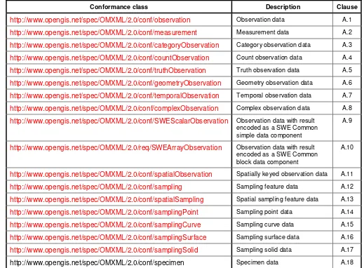
2.3 Conformance classes related to Observations and Measurements instances
The conformance rules are based on XML validation using the XML Schema representation of OMXML, together with processing of constraints expressed using Schematron assertions and reports.
Table 1 — Conformance classes related Observations and Measurements instances
Conformance class Description Clause
http://www.opengis.net/spec/OMXML/2.0/conf/observation Observation data A.1
http://www.opengis.net/spec/OMXML/2.0/conf/measurement Measurement data A.2
http://www.opengis.net/spec/OMXML/2.0/conf/categoryObservation Category observation data A.3
http://www.opengis.net/spec/OMXML/2.0/conf/countObservation Count observation data A.4
http://www.opengis.net/spec/OMXML/2.0/conf/truthObservation Truth observation data A.5
http://www.opengis.net/spec/OMXML/2.0/conf/geometryObservation Geometry observation data A.6
http://www.opengis.net/spec/OMXML/2.0/conf/temporalObservation Temporal observation data A.7
http://www.opengis.net/spec/OMXML/2.0/conf/complexObservation Complex observation data A.8
http://www.opengis.net/spec/OMXML/2.0/conf/SWEScalarObservation Observation data with result
encoded as a SWE Common simple data component
A.9
http://www.opengis.net/spec/OMXML/2.0/req/SWEArrayObservation Observation data with result
encoded as a SWE Common block data component
A.10
http://www.opengis.net/spec/OMXML/2.0/conf/spatialObservation Spatially keyed observation data A.11
http://www.opengis.net/spec/OMXML/2.0/conf/sampling Sampling feature data A.12
http://www.opengis.net/spec/OMXML/2.0/conf/spatialSampling Spatial sampling feature data A.13
http://www.opengis.net/spec/OMXML/2.0/conf/samplingPoint Sampling point data A.14
http://www.opengis.net/spec/OMXML/2.0/conf/samplingCurve Sampling curve data A.15
http://www.opengis.net/spec/OMXML/2.0/conf/samplingSurface Sampling surface data A.16
http://www.opengis.net/spec/OMXML/2.0/conf/samplingSolid Sampling solid data A.17
3 Normative references
The following referenced documents are indispensable for the application of this document. For dated references, only the edition cited applies. For undated references, the latest edition of the referenced document (including any amendments) applies.
Geographic information – metadata – XML implementation ISO/TS 19139:2007. urn:iso:TS:iso:19139
OGC Geography Markup Language v3.2 OGC Document 07-036
http://www.opengis.net/doc/IS/GML/3.2 (also published as ISO 19136:2007, Geographic information — Geography Markup Language)
MIME Media Types for GML OGC Document 09-141r1 http://portal.opengeospatial.org/files/?artifact_id=37743
Namespaces in XML 1.0 (Third Edition) W3C Recommendation (8 December 2009) http://www.w3.org/TR/xml-names/
OGC Observations and Measurements v2.0 OGC Document 10-004r1
http://www.opengis.net/doc/AS/OM/2.0 (also published as ISO/DIS 19156:2010, Geographic information — Observations and Measurements)
OGC Naming Authority (OGC-NA) Policies & Procedures OGC Document 09-046r2 http://www.opengis.net/doc/POL/OGC-NA/1.1
Policy Directives for Writing and Publishing OGC Standards: TC Decisions. OGC Document 06-135r9. http://www.opengis.net/doc/POL/Standards/2.0.3
Schematron: ISO/IEC 19757-3, Information technology — Document Schema Definition Languages (DSDL) — Part 3: Rule-based validation — Schematron
http://standards.iso.org/ittf/PubliclyAvailableStandards/c040833_ISO_IEC_19757-3_2006(E).zip
The Specification Model — A Standard for Modular specifications OGC Document 08-131r3. http://www.opengis.net/doc/POL/MOD-SPEC/1.0
OGC SWE Common Data Model Encoding Standard v2.0 OGC Document 08-094r1 http://www.opengis.net/doc/IS/SWE/2.0
XML Schema Part 1: Structures Second Edition. W3C Recommendation (28 October 2004) http://www.w3.org/TR/xmlschema-1/
4 Terms and definitions
For the purposes of this document, the following terms and definitions apply.
4.1
all-components document
XML schema document that includes, either directly or indirectly, all of the components defined and declared in a namespace
[OGC Policy Directives. http://www.opengis.net/doc/POL/Standards/2.0.3]
4.2
application schema
conceptual schema for data required by one or more applications
[ISO 19101:2002, definition 4.2]
4.3
element <XML>
basic information item of an XML document containing child elements, attributes and character data
[ISO 19136:2007]
NOTE From the XML Information Set: ―Each XML document contains one or more elements, the boundaries of which are either delimited by start-tags and end-tags, or, for empty elements, by an empty-element tag. Each element has a type, identified by name, sometimes called its ‗generic identifier‘ (GI), and may have a set of attribute specifications. Each attribute specification has a name and a value.
4.4
GML application schema
application schema written in XML Schema in accordance with the rules specified in ISO 19136:2007
[ISO 19136:2007]
4.5
GML document
XML document with a root element that is one of the elements AbstractFeature, Dictionary or TopoComplex specified in the GML schema or any element of a substitution group of any of these elements
[ISO 19136:2007]
4.6
GML schema
4.7
measurement
set of operations having the object of determining the value of a quantity
[ISO/TS 19101-2:2008, definition 4.20]
4.8
observation
act of observing a property
NOTE The goal of an observation may be to measure or otherwise determine the value of a property
[ISO/DIS 19156:2010]
4.9
observation result
estimate of the value of a property determined through a known procedure
[ISO/DIS 19156:2010]
4.10
sampling feature
feature, such as a station, transect, section or specimen, which is involved in making
observations concerning a domain feature
NOTE A sampling feature is purely an artefact of the observational strategy, and has no significance independent of the observational campaign.
[ISO/DIS 19156:2010]
4.11
schema <XML Schema>
collection of schema components within the same target namespace
EXAMPLE Schema components of W3C XML Schema are types, elements, attributes, groups, etc.
[ISO 19136:2007]
4.12
schema document <XML Schema>
XML document containing schema component definitions and declarations
NOTE The W3C XML Schema provides an XML interchange format for schema information. A single schema document provides descriptions of components associated with a single XML namespace, but several documents may describe components in the same schema, i.e. the same target namespace.
5 Conventions
5.1 Abbreviated terms
GML Geography Markup Language
O&M Observations and Measurements
OMXML Observations and Measurements XML Implementation
OGC Open Geospatial Consortium
SOS Sensor Observation Service
SWE Sensor Web Enablement
UML Unified Modeling Language
XML Extensible Markup Language
XSD W3C XML Schema Definition Language
5.2 Schema language
The XML implementation specified in this Standard is described using the XML Schema language (XSD) [XML Schema Part 1: Structures , XML Schema Part 2: Datatypes] and Schematron [ISO/IEC 19757-3, Information technology — Document Schema Definition Languages (DSDL) — Part 3: Rule-based validation — Schematron ].
5.3 Document presentation of the specification
This document presents the OMXML specification using a representation that follows the structures defined in the OGC Policy [The Specification Model — A Standard for
Modular specifications]. All normative material is organized as requirements,
6 XML Schema for Observations and Sampling Features
6.1 Introduction
6.2 XML Schema Packaging
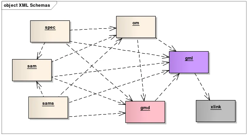
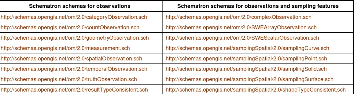
OMXML is packaged in schema documents describing four XML namespaces together with 16 Schematron schemas defining additional XML constraints. The OMXML schemas are available from the OGC schema repository at http://schemas.opengis.net. There are dependencies on components from seven XML namespaces described in other standards.
NOTE: Different XML Namespaces allow for independent maintenance (versioning) of groups of components without impacting on their dependencies.
The XML Namespaces for OMXML and their representations as XML Schema
documents are listed in Table 2. The OMXML Schematron schemas are listed in Table 3. The external dependencies are listed in Table 4. The direct dependencies between XML Schemas (implemented as <import> elements) are shown in Figure 1.
NOTE: In the XML Schema context, direct dependencies are those namespaces that are the target of an <xs:import> element. In the Schematron context, dependencies are loaded using <sch:ns> and <xsl:import-schema> elements.
obj ect XML Schemas
spec
sams sam
om
gml
xlink gmd
Figure 1. OMXML XML Schema dependencies. Dependency arrows indicate <import> elements in the schemas. Names correspond to the default namespace
6.3 XML elements
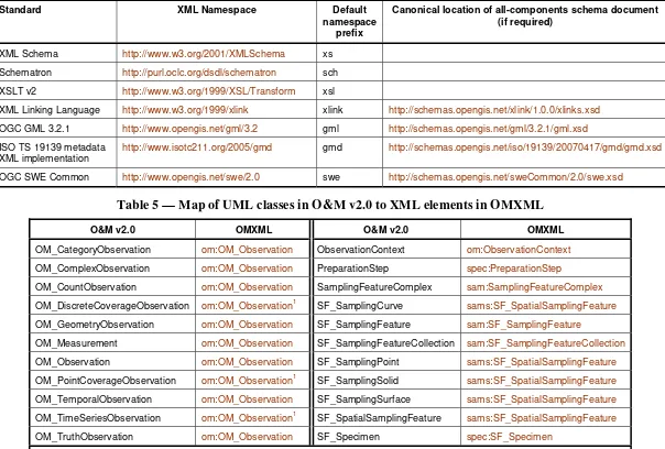
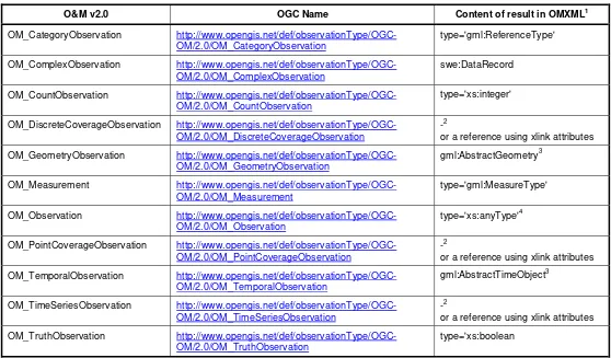
The schema is conformant to the rules for a GML Application Schema [OGC Geography Markup Language v3.2] and follows a UML to XML encoding rule explained in Annex C. This means that UML classes are implemented as XML elements, through global declarations in the XML schema. The correspondence of XML elements to the classes from OGC Observations and Measurements v2.0 is given in Table 5.
The XML encoding also makes use of type identifiers, provided as OGC URIs. A mapping of the UML classes to OGC URIs, and the corresponding XML content model constraints are given in Tables 6 and 7. These are used in the requirements classes described in Clause 7.
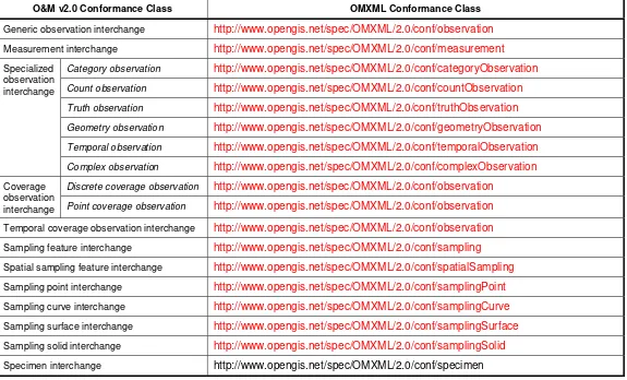
6.4 Conformance with O&M model
OMXML satisfies the 'Conformance Classes related to Application Schemas including Observations and Measurements' listed in Clause 2.2 of OGC Observations and Measurements v2.0 . The map from O&M v2.0 Conformance Classes to OMXML is given in Table 8.
Table 2 — XML Namespaces defined for this implementation of the Observations and Measurements schema
XML Namespace Default
namespace prefix
Canonical location of all-components schema document
http://www.opengis.net/om/2.0 om http://schemas.opengis.net/om/2.0/observation.xsd
http://www.opengis.net/sampling/2.0 sam http://schemas.opengis.net/sampling/2.0/samplingFeature.xsd
http://www.opengis.net/samplingSpatial/2.0 sams http://schemas.opengis.net/samplingSpatial/2.0/spatialSamplingFeature.xsd
http://www.opengis.net/samplingSpecimen/2.0 spec http://schemas.opengis.net/samplingSpecimen/2.0/specimen.xsd
Table 3 — Schematron schemas used in this implementation of the Observations and Measurements schema
Schematron schemas for observations Schematron schemas for observations and sampling features
http://schemas.opengis.net/om/2.0/categoryObservation.sch http://schemas.opengis.net/om/2.0/complexObservation.sch
http://schemas.opengis.net/om/2.0/countObservation.sch http://schemas.opengis.net/om/2.0/SWEArrayObservation.sch
http://schemas.opengis.net/om/2.0/geometryObservation.sch http://schemas.opengis.net/om/2.0/SWEScalarObservation.sch
http://schemas.opengis.net/om/2.0/measurement.sch http://schemas.opengis.net/samplingSpatial/2.0/samplingCurve.sch
http://schemas.opengis.net/om/2.0/spatialObservation.sch http://schemas.opengis.net/samplingSpatial/2.0/samplingPoint.sch
http://schemas.opengis.net/om/2.0/temporalObservation.sch http://schemas.opengis.net/samplingSpatial/2.0/samplingSolid.sch
http://schemas.opengis.net/om/2.0/truthObservation.sch http://schemas.opengis.net/samplingSpatial/2.0/samplingSurface.sch
Table 4 — External XML Namespaces used in this implementation of the Observations and Measurements schema
Standard XML Namespace Default
namespace prefix
Canonical location of all-components schema document (if required)
XML Schema http://www.w3.org/2001/XMLSchema xs
Schematron http://purl.oclc.org/dsdl/schematron sch
XSLT v2 http://www.w3.org/1999/XSL/Transform xsl
XML Linking Language http://www.w3.org/1999/xlink xlink http://schemas.opengis.net/xlink/1.0.0/xlinks.xsd
OGC GML 3.2.1 http://www.opengis.net/gml/3.2 gml http://schemas.opengis.net/gml/3.2.1/gml.xsd
ISO TS 19139 metadata XML implementation
http://www.isotc211.org/2005/gmd gmd http://schemas.opengis.net/iso/19139/20070417/gmd/gmd.xsd
OGC SWE Common http://www.opengis.net/swe/2.0 swe http://schemas.opengis.net/sweCommon/2.0/swe.xsd
Table 5 — Map of UML classes in O&M v2.0 to XML elements in OMXML
O&M v2.0 OMXML O&M v2.0 OMXML
OM_CategoryObservation om:OM_Observation ObservationContext om:ObservationContext
OM_ComplexObservation om:OM_Observation PreparationStep spec:PreparationStep
OM_CountObservation om:OM_Observation SamplingFeatureComplex sam:SamplingFeatureComplex
OM_DiscreteCoverageObservation om:OM_Observation1 SF_SamplingCurve sams:SF_SpatialSamplingFeature
OM_GeometryObservation om:OM_Observation SF_SamplingFeature sam:SF_SamplingFeature
OM_Measurement om:OM_Observation SF_SamplingFeatureCollection sam:SF_SamplingFeatureCollection
OM_Observation om:OM_Observation SF_SamplingPoint sams:SF_SpatialSamplingFeature
OM_PointCoverageObservation om:OM_Observation1 SF_SamplingSolid sams:SF_SpatialSamplingFeature
OM_TemporalObservation om:OM_Observation SF_SamplingSurface sams:SF_SpatialSamplingFeature
OM_TimeSeriesObservation om:OM_Observation1 SF_SpatialSamplingFeature sams:SF_SpatialSamplingFeature
OM_TruthObservation om:OM_Observation SF_Specimen spec:SF_Specimen
4.13 1
Table 6 — Map of UML classes in O&M v2.0 to OGC observation-type names and observation result-types
O&M v2.0 OGC Name Content of result in OMXML1
OM_CategoryObservation
http://www.opengis.net/def/observationType/OGC-or a reference using xlink attributes
OM_GeometryObservation http://www.opengis.net/def/observationType/OGC-OM/2.0/OM_GeometryObservation
gml:AbstractGeometry3
OM_Measurement http://www.opengis.net/def/observationType/OGC-OM/2.0/OM_Measurement
type='gml:MeasureType'
or a reference using xlink attributes
OM_TemporalObservation
http://www.opengis.net/def/observationType/OGC-or a reference using xlink attributes
OM_TruthObservation http://www.opengis.net/def/observationType/OGC-OM/2.0/OM_TruthObservation
type='xs:boolean
1 An XML element name indicates that the result in this case has element content; type='…' indicates that the result has 'simple'
(non-element) content.
2
gml:AbstractDiscreteCoverage, cvi:CV_AbstractDiscreteCoverage, gml:MultiPointCoverage, cvi:CV_DiscretePointCoverage are available for encoding coverages in XML, but the preferred OGC encoding for coverages is under revision.
3 A concrete member of the substitution group shall substitute for an abstract element. 4
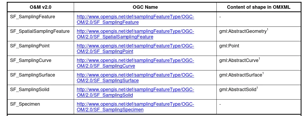
Table 7 — Map of UML classes in O&M v2.0 to OGC sampling-feature-type names and spatial-sampling-feature shape-types
O&M v2.0 OGC Name Content of shape in OMXML
SF_SamplingFeature http://www.opengis.net/def/samplingFeatureType/OGC-OM/2.0/SF_SamplingFeature
-
SF_SpatialSamplingFeature http://www.opengis.net/def/samplingFeatureType/OGC-OM/2.0/SF_SpatialSamplingFeature
gml:AbstractGeometry1
SF_SamplingPoint http://www.opengis.net/def/samplingFeatureType/OGC-OM/2.0/SF_SamplingPoint
gml:Point
SF_SamplingCurve http://www.opengis.net/def/samplingFeatureType/OGC-OM/2.0/SF_SamplingCurve
gml:AbstractCurve1
SF_SamplingSurface http://www.opengis.net/def/samplingFeatureType/OGC-OM/2.0/SF_SamplingSurface
gml:AbstractSurface1
SF_SamplingSolid http://www.opengis.net/def/samplingFeatureType/OGC-OM/2.0/SF_SamplingSolid
gml:AbstractSolid1
SF_Specimen http://www.opengis.net/def/samplingFeatureType/OGC-OM/2.0/SF_SamplingSpecimen
-
Table 8 —Map of O&M v2.0 Conformance Classes to OMXML.
O&M v2.0 Conformance Class OMXML Conformance Class
Generic observation interchange http://www.opengis.net/spec/OMXML/2.0/conf/observation
Measurement interchange http://www.opengis.net/spec/OMXML/2.0/conf/measurement
Specialized observation interchange
Category observation http://www.opengis.net/spec/OMXML/2.0/conf/categoryObservation
Count observation http://www.opengis.net/spec/OMXML/2.0/conf/countObservation
Truth observation http://www.opengis.net/spec/OMXML/2.0/conf/truthObservation
Geometry observation http://www.opengis.net/spec/OMXML/2.0/conf/geometryObservation
Temporal observation http://www.opengis.net/spec/OMXML/2.0/conf/temporalObservation
Complex observation http://www.opengis.net/spec/OMXML/2.0/conf/complexObservation
Coverage observation interchange
Discrete coverage observation http://www.opengis.net/spec/OMXML/2.0/conf/observation
Point coverage observation http://www.opengis.net/spec/OMXML/2.0/conf/observation
Temporal coverage observation interchange http://www.opengis.net/spec/OMXML/2.0/conf/observation
Sampling feature interchange http://www.opengis.net/spec/OMXML/2.0/conf/sampling
Spatial sampling feature interchange http://www.opengis.net/spec/OMXML/2.0/conf/spatialSampling
Sampling point interchange http://www.opengis.net/spec/OMXML/2.0/conf/samplingPoint
Sampling curve interchange http://www.opengis.net/spec/OMXML/2.0/conf/samplingCurve
Sampling surface interchange http://www.opengis.net/spec/OMXML/2.0/conf/samplingSurface
Sampling solid interchange http://www.opengis.net/spec/OMXML/2.0/conf/samplingSolid
7 Requirements for XML instances of Observations and Measurements
7.1 Introduction
An Observations and Measurements data document will include one or more of the XML elements listed in Table 5, or elements declared to be in the substitution group of one or more of these. The basic requirements for data instances are, therefore, formalized in terms of these elements. The corresponding conformance tests use document validation using various combinations of schema documents.
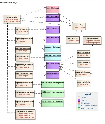
18 requirements classes are described in this clause. Figure 2 provides a graphical (informative) summary of the dependencies of the requirements classes.
NOTE: ISO 19115, GML and W3C XML Schema are not formally structured with Requirements Classes in the sense described by The Specification Model — A Standard for Modular specifications (OGC 08-131r3), so the specific dependencies on these are indicated using clause numbers or internal document anchors instead.
7.2 Virtual typing strategy
Only a single XML element for observations is provided (om:OM_Observation) whose result is a wildcard (type='xs:anyType'). The specialized observations described in the conceptual model merely restrict the type of the result, so in the XML implementation this can be achieved efficiently through a lightweight XML Schema for the generic case, supplemented by Schematron to test the result type. An (optional) 'type' sub-element allows a data instance to be associated with a class in the conceptual model. Note that addition of a suitable xsi:type attribute on the result element would enable XML Schema-based validation strategies to be applied, but this tactic is optional. Schematron-Schema-based validation does not require it.
Similarly, only a single XML element for spatial sampling features is provided (sams:SF_SpatialSamplingFeature) whose shape property contains a wildcard (gml:AbstractGeometry). The specialized spatial sampling features described in the conceptual model merely restrict the type of the shape, so in the XML implementation this can be achieved efficiently through a lightweight XML Schema for the generic case, supplemented by Schematron to test the shape. An (optional) 'type' sub-element allows a data instance to be associated with a class in the conceptual model. Note that addition of a suitable xsi:type attribute on the shape element would enable XML Schema-based
obj ect Requirements
+ specimen-valid + shape-type-consistent + spatialSampling-valid
Figure 2. (informative) Dependencies of OMXML requirements classes. Note that req/observation has no external dependencies, so is the core requirements class in
7.3 Requirements class: Generic observation data
XML representation of observation data requires use of the element om:OM_Observation or a member of its substitution group.
There is a dependency on the requirements classes for GML documents, defined in Clause 2.4 of OGC Geography Markup Language v3.2.
There is a dependency on the requirements class for Geographic Metadata XML encoding, described in Clause 6 of Geographic information – metadata – XML implementation.
Requirements Class
http://www.opengis.net/spec/OMXML/2.0/req/observation
Target type Data instance
Dependency http://www.opengis.net/doc/IS/GML/3.2#clause-2.4
Dependency urn:iso:ts:iso:19139:clause:6
Requirement
http://www.opengis.net/spec/OMXML/2.0/req/observation/observation-valid
Any XML element in the substitution group of om:OM_Observation SHALL be well-formed and valid
Requirement
http://www.opengis.net/spec/OMXML/2.0/req/observation/result-type-consistent
The content model of any om:result element SHALL be consistent with the value of the xlink:href attribute of the om:type element if one is present as a sub-element of the parent om:OM_Observation, according to the mapping given in Table 5.
This is the core requirements class for all XML instances of Observations and Measurements.
7.4 Requirements class: Measurement data
XML representation of measurement data requires that it satisfies the core requirements class for observation data, and adds the requirement that the observation result is a scaled number.
Requirements Class
http://www.opengis.net/spec/OMXML/2.0/req/measurement
Target type Data instance
Dependency http://www.opengis.net/spec/OMXML/2.0/req/observation
Dependency http://www.opengis.net/doc/IS/GML/3.2#clause-8.2
Requirement http://www.opengis.net/spec/OMXML/2.0/req/measurement/result-measure
The XML element om:result SHALL have a value that matches the content model defined by gml:MeasureType.
7.5 Requirements class: Category observation data
XML representation of category observation data requires that it satisfies the core requirements class for observation data, and adds the requirement that the observation result selects an item from a controlled vocabulary or ontology.
There is a dependency on the requirements class for GML Base Schema Components, described in Clause 7.2 of OGC Geography Markup Language v3.2.
Requirements Class
http://www.opengis.net/spec/OMXML/2.0/req/categoryObservation
Target type Data instance
Dependency http://www.opengis.net/spec/OMXML/2.0/req/observation
Dependency http://www.opengis.net/doc/IS/GML/3.2#clause-7.2
Requirement
http://www.opengis.net/spec/OMXML/2.0/req/categoryObservation/result-category
The XML element om:result SHALL have a value that matches the content model defined by gml:ReferenceType.
7.6 Requirements class: Count observation data
XML representation of count observation data requires that it satisfies the core
requirements class for observation data, and adds the requirement that the observation result is an integer.
Requirements Class
http://www.opengis.net/spec/OMXML/2.0/req/countObservation
Target type Data instance
Dependency http://www.opengis.net/spec/OMXML/2.0/req/observation
Dependency http://www.w3.org/TR/xmlschema-2/#integer
Requirement
http://www.opengis.net/spec/OMXML/2.0/req/countObservation/result-integer
The XML element om:result SHALL have a value that matches the content model defined by xs:integer.
7.7 Requirements class: Truth observation data
XML representation of truth observation data requires that it satisfies the core
requirements class for observation data, and adds the requirement that the observation result is a truth value.
There is a dependency on elements from XML Schema Part 2: Datatypes (clause 3.2.2).
Requirements Class
http://www.opengis.net/spec/OMXML/2.0/req/truthObservation
Target type Data instance
Dependency http://www.opengis.net/spec/OMXML/2.0/req/observation
Dependency http://www.w3.org/TR/xmlschema-2/#boolean
Requirement
http://www.opengis.net/spec/OMXML/2.0/req/truthObservation/result-boolean
The XML element om:result SHALL have a value that matches the content model defined by xs:boolean.
7.8 Requirements class: Geometry observation data
XML representation of geometry observation data requires that it satisfies the core requirements class for observation data, and adds the requirement that the observation result is a spatial object.
Requirements Class
http://www.opengis.net/spec/OMXML/2.0/req/geometryObservation
Target type Data instance
Dependency http://www.opengis.net/spec/OMXML/2.0/req/observation
Dependency http://www.opengis.net/doc/IS/GML/3.2#clause-10
Requirement http://www.opengis.net/spec/OMXML/2.0/req/geometryObservation
/result-geometry
The XML element om:result SHALL contain a subelement in the substitution group of gml:AbstractGeometry.
7.9 Requirements class: Temporal observation data
XML representation of temporal observation data requires that it satisfies the core requirements class for observation data, and adds the requirement that the observation result is a temporal object.
There is a dependency on the requirements class for Temporal schema, described in Clause 14 of OGC Geography Markup Language v3.2.
Requirements Class
http://www.opengis.net/spec/OMXML/2.0/req/temporalObservation
Target type Data instance
Dependency http://www.opengis.net/spec/OMXML/2.0/req/observation
Dependency http://www.opengis.net/doc/IS/GML/3.2#clause-14
Requirement http://www.opengis.net/spec/OMXML/2.0/req/temporalObservation/res
ult-time-object
The XML element om:result SHALL contain a subelement in the substitution group of gml:AbstractTimeObject.
7.10 Requirements class: Complex observation data
There is a dependency on the requirements class for SWE Common –Record Components, described in Clause 8.2 of OGC SWE Common Data Model Encoding Standard v2.0.
Requirements Class
http://www.opengis.net/spec/OMXML/2.0/req/complexObservation
Target type Data instance
Dependency http://www.opengis.net/spec/OMXML/2.0/req/observation
Dependency http://www.opengis.net/spec/SWE/2.0/req/xsd-record-components
Requirement http://www.opengis.net/spec/OMXML/2.0/req/complexObservation/re
sult-SWErecord
The XML element om:result SHALL contain a subelement swe:DataRecord or swe:Vector containing inline values.
7.11 Requirements class: SWE scalar observation data
XML representation of SWE observation data requires that it satisfies the core
requirements class for observation data, and adds the requirement that the observation result is a simple data component from the SWE Common Data Model.
There is a dependency on the requirements class for SWE Common – Basic Types and Simple Components, described in Clause 8.1 of OGC SWE Common Data Model Encoding Standard v2.0.
Requirements Class
http://www.opengis.net/spec/OMXML/2.0/req/SWEScalarObservation
Target type Data instance
Dependency http://www.opengis.net/spec/OMXML/2.0/req/observation
Dependency http://www.opengis.net/spec/SWE/2.0/req/xsd-simple-components
Requirement http://www.opengis.net/spec/OMXML/2.0/req/SWEArrayObservatio
n/result-SWEBlock/result-SWEScalar
7.12 Requirements class: SWE array observation data
XML representation of SWE observation data requires that it satisfies the core
requirements class for observation data, and adds the requirement that the observation result is a block data component from the SWE Common Data Model.
There is a dependency on the requirements class for SWE Common – Block
Components, described in Clause 8.4 of OGC SWE Common Data Model Encoding Standard v2.0.
Requirements Class
http://www.opengis.net/spec/OMXML/2.0/req/SWEArrayObservation
Target type Data instance
Dependency http://www.opengis.net/spec/OMXML/2.0/req/observation
Dependency http://www.opengis.net/spec/SWE/2.0/req/xsd-block-components
Requirement http://www.opengis.net/spec/OMXML/2.0/req/SWEArrayObservati
on/result-SWEBlock
The XML element om:result SHALL contain a subelement
swe:DataArray, swe:Matrix or swe:DataStream containing inline values.
7.13 Requirements class: Spatial observation data
XML representation of spatial observation data requires that it satisfies the core requirements class for observation data, and adds the requirement that the observation shall have exactly one parameter which contains the sampling geometry of the
observation. The sampling geometry represents the spatial extent where the observation result applies to. This is usually the extent of the observation's feature of interest but may also be computed or determined by other means.
There is a dependency on the requirements class for GML schema - Geometric Primitives, described in Clause 10 of OGC Geography Markup Language v3.2.
Requirements Class
http://www.opengis.net/spec/OMXML/2.0/req/SpatialObservation
Dependency http://www.opengis.net/spec/OMXML/2.0/req/observation
Dependency http://www.opengis.net/doc/IS/GML/3.2#clause-10
tial-parameter
A spatial observation SHALL have exactly one sampling geometry encoded as XML element om:parameter in an observation.
Requirement http://www.opengis.net/spec/OMXML/2.0/req/SpatialObservation/spa
tial-parameter-name
The xlink:href attribute in the XML element om:name of the
om:parameter/om:NamedValue element that carries the sampling geometry
SHALL have the value
http://www.opengis.net/def/param-name/OGC-OM/2.0/samplingGeometry.
Requirement http://www.opengis.net/spec/OMXML/2.0/req/SpatialObservation/spa
tial-parameter-value
The XML element om:value in the om:parameter/om:NamedValue element SHALL contain a subelement in the substitution group of
gml:AbstractGeometry.
7.14 Requirements class: Sampling feature data
XML representation of sampling feature data requires use of the element sam:SF_SamplingFeature or a member of its substitution group.
There is a dependency on the requirements classes for GML documents, defined in Clause 2.4 of OGC Geography Markup Language v3.2.
There is a dependency on the requirements class for Geographic Metadata XML encoding, described in Clause 6 of Geographic information – metadata – XML implementation.
Requirements Class
http://www.opengis.net/spec/OMXML/2.0/req/sampling
Target type Data instance
Dependency http://www.opengis.net/doc/IS/GML/3.2#clause-2.4
Dependency urn:iso:ts:iso:19139:clause:6
Dependency http://www.opengis.net/spec/OMXML/2.0/req/observation
Requirement http://www.opengis.net/spec/OMXML/2.0/req/sampling/sampling-valid
This is the core requirements class for all XML instances of Sampling Features.
7.15 Requirements class: Spatial sampling feature data
XML representation of spatial sampling feature data requires use of the element sams:SF_SpatialSamplingFeature or a member of its substitution group.
There is a dependency on the requirements class for GML schema – Abstract Geometry, described in Clause 10.1.3 of OGC Geography Markup Language v3.2.
Requirements Class
http://www.opengis.net/spec/OMXML/2.0/req/spatialSampling
Target type Data instance
Dependency http://www.opengis.net/spec/OMXML/2.0/req/sampling
Dependency http://www.opengis.net/doc/IS/GML/3.2#clause-10.1.3
Requirement http://www.opengis.net/spec/OMXML/2.0/req/spatialSampling/spatial
Sampling-valid
Any XML element in the substitution group of
sams:SF_SpatialSamplingFeature SHALL be well-formed and valid.
Requirement
http://www.opengis.net/spec/OMXML/2.0/req/spatialSampling/shape-type-consistent
The content model of any sams:shape element SHALL be consistent with the value of the xlink:href attribute of the sam:type element if one is present as a sub-element of the parent sams:SF_SpatialSamplingFeature, according to the mapping given in Table 6.
This is the core requirements class for all XML instances of Spatial Sampling Features.
7.16 Requirements class: Sampling point data
XML representation of sampling point data requires that it satisfies the core requirements class for spatial sampling feature data, and adds the requirement that the shape is a point.
There is a dependency on the requirements class for GML schema - Geometric Primitives, described in Clause 10 of OGC Geography Markup Language v3.2.
Requirements Class
Target type Data instance
Dependency http://www.opengis.net/spec/OMXML/2.0/req/spatialSampling
Dependency http://www.opengis.net/doc/IS/GML/3.2#clause-10
Requirement
http://www.opengis.net/spec/OMXML/2.0/req/samplingPoint/shape-point
The XML element sams:shape SHALL contain a subelement in the substitution group of gml:Point or a link to a representation of a point.
7.17 Requirements class: Sampling curve data
XML representation of sampling curve data requires that it satisfies the core requirements class for spatial sampling feature data, and adds the requirement that the shape is a curve.
There is a dependency on the requirements class for GML schema - Geometric Primitives, described in Clause 10 of OGC Geography Markup Language v3.2.
Requirements Class
http://www.opengis.net/spec/OMXML/2.0/req/samplingCurve
Target type Data instance
Dependency http://www.opengis.net/spec/OMXML/2.0/req/spatialSampling
Dependency http://www.opengis.net/doc/IS/GML/3.2#clause-10
Requirement
http://www.opengis.net/spec/OMXML/2.0/req/samplingCurve/shape-curve
The XML element sams:shape SHALL contain a subelement in the substitution group of gml:AbstractCurve or a link to a representation of a curve.
7.18 Requirements class: Sampling surface data
XML representation of sampling surface data requires that it satisfies the core
requirements class for spatial sampling feature data, and adds the requirement that the shape is a surface.
Requirements Class
http://www.opengis.net/spec/OMXML/2.0/req/samplingSurface
Target type Data instance
Dependency http://www.opengis.net/spec/OMXML/2.0/req/spatialSampling
Dependency http://www.opengis.net/doc/IS/GML/3.2#clause-10
Requirement
http://www.opengis.net/spec/OMXML/2.0/req/samplingSurface/shape-surface
The XML element sams:shape SHALL contain a subelement in the substitution group of gml:AbstractSurface or a link to a representation of a surface.
7.19 Requirements class: Sampling solid data
XML representation of sampling solid data requires that it satisfies the core requirements class for spatial sampling feature data, and adds the requirement that the shape is a solid.
There is a dependency on the requirements class for GML schema - Geometric Primitives, described in Clause 10 of OGC Geography Markup Language v3.2.
Requirements Class
http://www.opengis.net/spec/OMXML/2.0/req/samplingSolid
Target type Data instance
Dependency http://www.opengis.net/spec/OMXML/2.0/req/spatialSampling
Dependency http://www.opengis.net/doc/IS/GML/3.2#clause-10
Requirement
http://www.opengis.net/spec/OMXML/2.0/req/samplingSolid/shape-solid
The XML element sams:shape SHALL contain a subelement in the substitution group of gml:AbstractSolid or a link to a representation of a solid.
7.20 Requirements class: Specimen data
There is a dependency on the requirements class for GML schema – Referencing, described in Clause 7.2.3.7 of OGC Geography Markup Language v3.2.
There is a dependency on the requirements class for GML schema – Abstract Geometry, described in Clause 10.1.3 of OGC Geography Markup Language v3.2.Requirements Class
http://www.opengis.net/spec/OMXML/2.0/req/specimen Target type Data instance
Dependency http://www.opengis.net/spec/OMXML/2.0/req/sampling
Dependency http://www.opengis.net/doc/IS/GML/3.2#clause-7.2.3.7
Dependency http://www.opengis.net/doc/IS/GML/3.2#clause-10.1.3
Requirement http://www.opengis.net/spec/OMXML/2.0/req/specimen/specimen-valid
Any XML element in the substitution group of spec:SF_Specimen SHALL be well-formed and valid.
8 Media types for Observations and Measurements data
Observations and measurements data conforming to this specification is encoded in GML-conformant XML documents. The standard MIME-type and sub-type for GML data should be used to indicate the encoding in internet exchange, as specified in MIME Media Types for GML , namely
Annex A
Abstract test suite
(normative)
A.1 Conformance class: Generic observation data
This is the core conformance class for XML implementation of Observations and Measurements data.
There is a dependency on the conformance class for GML documents, defined in clause 2.4 (with the test suite in A.3) of OGC Geography Markup Language v3.2.
There is a dependency on the conformance class for Geographic Metadata XML encoding, described in Clause 2 and Annex A of Geographic information – metadata – XML implementation.
Conformance Class
http://www.opengis.net/spec/OMXML/2.0/conf/observation
Requirements http://www.opengis.net/spec/OMXML/2.0/req/observation
Dependency http://www.opengis.net/doc/IS/GML/3.2/clause/2.4
NOTE: The OMXML schema imports the XML Schema for GML 3.2. However GML 3.2 conformance includes additional tests that are not enforced by schema validation.
Dependency urn:iso:ts:iso:19139:clause:2
NOTE: The OMXML schema imports the XML Schema for Geographic Metadata. However ISO 19139 conformance includes additional tests that are not enforced by schema validation.
Test
http://www.opengis.net/spec/OMXML/2.0/conf/observation/observation-valid
Requirement http://www.opengis.net/spec/OMXML/2.0/req/observation/
observation-valid
Test purpose Verify that any XML element in the substitution group of
om:OM_Observation is well-formed and valid
Test method Validate the XML document using the XML schema document
http://schemas.opengis.net/om/2.0/observation.xsd. Pass if no errors reported. Fail otherwise.
Test http://www.opengis.net/spec/OMXML/2.0/conf/observation/result-type-consistent
Requirement http://www.opengis.net/spec/OMXML/2.0/req/observation/r
esult-type-consistent
Test purpose Verify that the content model of any om:result element is
consistent with the value of the xlink:href attribute of the om:type element if one is present as a sub-element of the parent om:OM_Observation, according to the mapping given in Table 5.
Test method Validate the XML document using the Schematron document
http://schemas.opengis.net/om/2.0/resultTypeConsistent.sch. Pass if no errors reported. Fail otherwise.
Test type Capability
A.2 Conformance class: Measurement data
Conformance Class
http://www.opengis.net/spec/OMXML/2.0/conf/measurement
Requirements http://www.opengis.net/spec/OMXML/2.0/req/measurement
Dependency http://www.opengis.net/spec/OMXML/2.0/conf/observation
Test
http://www.opengis.net/spec/OMXML/2.0/conf/measurement/result-measure
Requirement http://www.opengis.net/spec/OMXML/2.0/req/measurement
/result-measure
Test purpose Verify that the XML element om:result has a value that matches
the content model defined by gml:MeasureType.
Test method Validate the XML document using the Schematron document
http://schemas.opengis.net/om/2.0/measurement.sch. Pass if no errors reported. Fail otherwise.
A.3 Conformance class: Category observation data
Conformance Class
http://www.opengis.net/spec/OMXML/2.0/conf/categoryObservation
Requirements http://www.opengis.net/spec/OMXML/2.0/req/categoryObservation
Dependency http://www.opengis.net/spec/OMXML/2.0/conf/observation
Test
http://www.opengis.net/spec/OMXML/2.0/conf/categoryObservation/result-category
Requirement http://www.opengis.net/spec/OMXML/2.0/req/categoryObse
rvation/result-category
Test purpose Verify that the XML element om:result has a value that matches
the content model defined by gml:ReferenceType
Test method Validate the XML document using the Schematron document
http://schemas.opengis.net/om/2.0/categoryObservation.sch. Pass if no errors reported. Fail otherwise.
Test type Capability
A.4 Conformance class: Count observation data
Conformance Class
http://www.opengis.net/spec/OMXML/2.0/conf/countObservation
Requirements http://www.opengis.net/spec/OMXML/2.0/req/countObservation
Dependency http://www.opengis.net/spec/OMXML/2.0/conf/observation
Test
http://www.opengis.net/spec/OMXML/2.0/conf/countObservation/result-integer
Requirement http://www.opengis.net/spec/OMXML/2.0/req/countObserv
ation/result-integer
Test purpose Verify that the XML element om:result has a value that matches
the content model defined by xs:integer.
Test method Validate the XML document using the Schematron document
http://schemas.opengis.net/om/2.0/countObservation.sch. Pass if no errors reported. Fail otherwise.
A.5 Conformance class: Truth observation data
Conformance Class
http://www.opengis.net/spec/OMXML/2.0/conf/truthObservation
Requirements http://www.opengis.net/spec/OMXML/2.0/req/truthObservation
Dependency http://www.opengis.net/spec/OMXML/2.0/conf/observation
Test
http://www.opengis.net/spec/OMXML/2.0/conf/truthObservation/result-boolean
Requirement http://www.opengis.net/spec/OMXML/2.0/req/truthObserva
tion/result-boolean
Test purpose Verify that the XML element om:result has a value that matches
the content model defined by xs:boolean.
Test method Validate the XML document using the Schematron document
http://schemas.opengis.net/om/2.0/truthObservation.sch. Pass if no errors reported. Fail otherwise.
Test type Capability
A.6 Conformance class: Geometry observation data
Conformance Class
http://www.opengis.net/spec/OMXML/2.0/conf/geometryObservation
Requirements http://www.opengis.net/spec/OMXML/2.0/req/geometryObservation
Dependency http://www.opengis.net/spec/OMXML/2.0/conf/observation
Test http://www.opengis.net/spec/OMXML/2.0/conf/geometryObservation/result
-geometry
Requirement http://www.opengis.net/spec/OMXML/2.0/req/geometryObs
ervation/result-geometry
Test purpose Verify that XML element om:result contains a subelement in
the substitution group of gml:AbstractGeometry.
Test method Validate the XML document using the Schematron document
Test type Capability
A.7 Conformance class: Temporal observation data
Conformance Class
http://www.opengis.net/spec/OMXML/2.0/conf/temporalObservation
Requirements http://www.opengis.net/spec/OMXML/2.0/req/temporalObservation
Dependency http://www.opengis.net/spec/OMXML/2.0/conf/observation
Test http://www.opengis.net/spec/OMXML/2.0/conf/temporalObservation/result
-time-object
Requirement http://www.opengis.net/spec/OMXML/2.0/req/temporalObs
ervation/result-time-object
Test purpose Verify that XML element om:result contains a subelement in
the substitution group of gml:AbstractTimeObject.
Test method Validate the XML document using the Schematron document
http://schemas.opengis.net/om/2.0/temporalObservation.sch. Pass if no errors reported. Fail otherwise.
Test type Capability
A.8 Conformance class: Complex observation data
There is a dependency on the conformance class for SWE Common – Record Components, described in Annex A.9 of OGC SWE Common Data Model Encoding Standard v2.0.
Conformance Class
http://www.opengis.net/spec/OMXML/2.0/conf/complexObservation
Requirements http://www.opengis.net/spec/OMXML/2.0/req/complexObservation
Dependency http://www.opengis.net/spec/OMXML/2.0/conf/observation
Dependency http://www.opengis.net/spec/SWE/2.0/conf/xsd-record-components
Test
Requirement http://www.opengis.net/spec/OMXML/2.0/req/complexObse rvation/result-SWErecord
Test purpose Verify that the XML element om:result contains a subelement
swe:DataRecord or swe:Vector with inline values.
Test method Validate the XML document using the Schematron document
http://schemas.opengis.net/om/2.0/complexObservation.sch. Pass if no errors reported. Fail otherwise.
Test type Capability
A.9 Conformance class: SWE scalar observation data
There is a dependency on the conformance class for SWE Common – Basic Types and Simple Components, described in Annex A.8 of OGC SWE Common Data Model Encoding Standard v2.0.
Conformance Class
http://www.opengis.net/spec/OMXML/2.0/conf/SWEScalarObservation
Requirements http://www.opengis.net/spec/OMXML/2.0/req/SWEArrayObservation/resul
t-SWEBlock
Dependency http://www.opengis.net/spec/OMXML/2.0/conf/observation
Dependency http://www.opengis.net/spec/SWE/2.0/conf/xsd-simple-components
Test http://www.opengis.net/spec/OMXML/2.0/conf/SWEScalarObservation/res
ult-SWEscalar
Requirement http://www.opengis.net/spec/OMXML/2.0/req/SWEArrayO
bservation/result-SWEBlock/result-SWEScalar
Test purpose Verify that the XML element om:result contains a concrete
subelement in the substitution group
swe:AbstractScalarComponent containing an inline value..
Test method Validate the XML document using the Schematron document
http://schemas.opengis.net/om/2.0/SWEScalarObservation.sch. Pass if no errors reported. Fail otherwise.
A.10 Conformance class: SWE array observation data
There is a dependency on the conformance class for SWE Common – Block
Components, described in Annex A.11 of OGC SWE Common Data Model Encoding Standard v2.0.
Conformance Class
http://www.opengis.net/spec/OMXML/2.0/conf/SWEArrayObservation
Requirements http://www.opengis.net/spec/OMXML/2.0/req/SWEArrayObservation
Dependency http://www.opengis.net/spec/OMXML/2.0/conf/observation
Dependency http://www.opengis.net/spec/SWE/2.0/conf/xsd-block-components
Test http://www.opengis.net/spec/OMXML/2.0/req/SWEArrayObservation/resul
t-SWEBlock
Requirement http://www.opengis.net/spec/OMXML/2.0/req/SWEArrayO
bservation/result-SWEBlock
Test purpose Verify that the XML element om:result contains a subelement
swe:DataArray, swe:Matrix or swe:DataStream containing inline values.
Test method Validate the XML document using the Schematron document
http://schemas.opengis.net/om/2.0/SWEArrayObservation.sch. Pass if no errors reported. Fail otherwise.
Test type Capability
A.11 Conformance class: Spatial observation data
Conformance Class
http://www.opengis.net/spec/OMXML/2.0/conf/spatialObservation
Requirements http://www.opengis.net/spec/OMXML/2.0/req/SpatialObservation
Dependency http://www.opengis.net/spec/OMXML/2.0/conf/observation
Test
http://www.opengis.net/spec/OMXML/2.0/conf/spatialObservation/spatial-parameter
Requiremen t
Requiremen
Verify that the observation has exactly one sampling geometry encoded as XML element om:parameter/om:NamedValue in an observation, and that its sub-element om:name has an xlink:href
attribute with the value
http://www.opengis.net/def/param-name/OGC-OM/2.0/samplingGeometry, and its sub-element om:value contains a subelement in the substitution group of gml:AbstractGeometry.
Test method Validate the XML document using the Schematron document
http://schemas.opengis.net/om/2.0/spatialObservation.sch. Pass if no errors reported. Fail otherwise.
Test type Capability
A.12 Conformance class: Sampling feature data
This is the core conformance class for XML implementation of Sampling Feature data.
There is a dependency on the conformance class for GML documents, defined in clause 2.4 (with the test suite in A.3) of OGC Geography Markup Language v3.2.
There is a dependency on the conformance class for Geographic Metadata XML encoding, described in Clause 2 and Annex A of Geographic information – metadata – XML implementation.
Conformance Class
http://www.opengis.net/spec/OMXML/2.0/conf/sampling
Requirements http://www.opengis.net/spec/OMXML/2.0/req/sampling
Dependency http://www.opengis.net/doc/IS/GML/3.2/clause/2.4
NOTE: The OMXML schema imports the XML Schema for GML 3.2. However GML 3.2 conformance includes additional tests that are not enforced by schema validation.
Dependency urn:iso:ts:iso:19139:clause:2