KABUPATEN CIREBON
DALAM ANGKA
2015
Cirebon Regency in Figure
KABUPATEN CIREBON DALAM ANGKA 2015
Cirebon Regency In Figures 2015
ISSN : 0215.4242
Nomor Publikasi / Publication Number : 32.09.1501
Katalog BPS / BPS Catalogue : 1403.3209
Ukuran Buku / Book Size : 17,0 X 23,5 cm
Jumlah Halaman / Number of Page : viii + 184 hal
NASKAH /
MANUSCRIPT
:
Seksi Neraca Wilayah dan Analisis Statistik
Section of Regional Account and Analysis of Statistic BPS - Statistics of Cirebon Regency
GAMBAR KULIT /
COVER DESIGN
:
Seksi Integrasi, Pengolahan dan Diseminasi Statistik
Section of Integration, Processing and Dissemination of Statistic BPS - Statistics of Cirebon Regency
DITERBITKAN OLEH / PUBLISHED BY : BPS KABUPATEN CIREBON
K A T A P E N G A N T A R
Dengan mengucapkan puji syukur ke hadirat Allah SWT, publikasi
Kabupaten Cirebon Dalam Angka Tahun 2015 dapat tersaji. Publikasi ini
diharapkan dapat memberikan gambaran hasil pembangunan di Kabupaten
Cirebon
.
Publikasi ini dibuat untuk membantu pihak-pihak yang memerlukan
data-data primer maupun sekunder. Namun demikian karena terbatasnya data-data yang
tersedia dari beberapa instansi terkait maka masih terdapat beberapa
keterbatasan penyajian informasi.
Publikasi ini akan lebih sempurna jika setiap instansi turut berpartisipasi
aktif dengan memberikan data tepat waktu sehingga dapat dihasilkan indikator
pembangunan yang lebih tajam dan sangat berarti di Kabupaten Cirebon.
Akhirnya kami mengucapkan terima kasih yang sebesar-besarnya kepada
semua pihak yang telah membantu hingga publikasi ini dapat diselesaikan.
Semoga publikasi ini dapat bermanfaat baik untuk keperluan penelitian,
evaluasi maupun perencanaan pembangunan di Kabupaten Cirebon.
Cirebon, Agustus 2015
BPS Kabupaten Cirebon
Kepala,
Ir. H. YAYAN EKA TAVIPIAN, MT
NIP. 19650212 199102 1 003
INTRODUCTION
With are grateful to Allah SWT, publication of Cirebon Regency in
Figures 2015 can be presented. This publication is expected to provide an
overview of development results in Cirebon.
This publication is designed to help those who require primary data and
secondary. However, because of the limited data available from several
agencies then there are some limitations to the presentation of information.
This publication will be perfect if each agency actively participate by
providing timely data so it can produce sharper development indicators and
very meaningful in Cirebon Regency.
Finally we wish to thank you profusely to all those who have helped to
this publication can be resolved. Hopefully, this publication can be useful both
for the purposes of research, evaluation and development planning in Cirebon
Regency.
Cirebon, August 2015
Statistics of Cirebon Regency
Chief,
Ir. H. YAYAN EKA TAVIPIAN, MT
NIP. 19650212 199102 1 003
SEKILAS TENTANG BPS
Badan Pusat Statistik (BPS) adalah lembaga pemerintah non departemen yang berada di bawah dan bertanggung jawab kepada presiden. Sesuai dengan UU No. 16 Tahun 1997 tentang Statistik, BPS adalah sebuah Lembaga Non Departemen yang vertikal sampai ke tingkat Propinsi/Kabupaten/Kota. Sedangkan di setiap kecamatan paling tidak terdapat seorang Koordinator Statistik Kecamatan yang bertanggung jawab dalam pengumpulan data statistik di wilayahnya.
Menurut UU Statistik, Statistik di kelompokan menjadi 3 jenis:
1. Statistik Dasar adalah statistik yang pemanfaatannya ditujukan untuk keperluan yang bersifat luas, baik bagi pemerintah maupun masyarakat, yang memiliki ciri-ciri lintas sektoral, berskala nasional, makro dan yang penyelenggaraannya menjadi tanggung jawab BPS.
2. Statistik Sektoral adalah statistik yang pemanfaatannya ditujukan untuk memenuhi kebutuhan instansi tertentu dalam rangka penyelenggaraan tugas-tugas pemerintah dan pembangunan yang merupakan tugas pokok instansi yang bersangkutan.
3. Statistik Khusus adalah statistik yang pemanfaatannya ditujukan untuk memenuhi kebutuhan spesifik dunia usaha, pendidikan, sosial budaya dan kepentingan lain dalam kehidupan masyarakat, yang penyelenggaraannya dilakukan oleh lembaga, organisasi, perorangan dan atau unsur masyarakat lainnya.
Data BPS
BPS sebagai instansi pemerintah penyedia informasi statistik untuk keperluan pemerintah, swasta dan masyarakat, BPS berusaha memenuhi kebutuhan data tersebut. Data yang tersedia BPS meliputi data pertanian, komunikasi, Indeks Harga Konsumen, konstruksi, energi, perdagangan luar negeri, pertambangan, keuangan, penduduk, pariwisata, transportasi, dan pendapatan.
Glance of Statistic Cirebon Regency
The Central Statistics Agency (BPS) is a non-departmental government agency that is subordinate and accountable to the president. In accordance with UU No. 16 of 1997 on Statistics, BPS is a Non-Departmental Institutions vertically up to the level of the Provincial / District / City. While in every district there are at least a sub-district coordinator of Statistics is responsible for collecting statistical data on its territory.
According to the UU of Statistics, Statistics grouped into 3 types :
1. Basic statistics are statistics utilized for a broad range of both government and society, which has the characteristics of cross-sectoral, national, macro and will be the responsibility of BPS.
2. Sectoral statistics are statistics utilized to meet the needs of particular institutions in the framework of the implementation of the tasks of government and development which is the principal task of the agency concerned.
3. Special statistics are statistics utilized to meet the specific needs of the business, educational, social, cultural and other interests in public life, which happen to be carried out by institutions, organizations, individuals and other public or element Data of BPS
BPS as a government agency providers of statistical information for the purposes of government, private and public, BPS try to meet the needs of the data.
BPS data available include data on agriculture, communications, consumer price index, construction, energy, foreign trade, mining, finance, population, tourism, transportation, and income.
Layanan BPS
BPS menghasilkan keragaman data statistik baik sosial maupun ekonomi, yang dimanfaatkan baik pemerintah, dunia usaha maupun masyarakat umum. Informasi dikemas baik dalam bentuk media cetak seperti buku, maupun media elektronik seperti publikasi elektronik dan internet. Untuk memenuhi kebutuhan statistik yang amat beragam, BPS dapat menyediakan informasi yang disesuaikan dengan kebutuhan penggunaan data.
Selain itu, beberapa ragam layanan yang dapat diberikan, antara lain: 1. Perencanaan survey, sampling maupun perencanaan kuesioner; 2. Pelatihan komputer dan statistik;
3. Konsultasi statistik. Kontak BPS
Produk BPS dapat diperoleh baik di BPS Pusat maupun perwakilan BPS di setiap ibukota Propinsi/Kabupaten/Kota di seluruh Indonesia.
Khusus untuk wilayah Kabupaten Cirebon akses ke BPS dapat menghubungi kantor BPS Kabupaten Cirebon di alamat Jln. Sunan Kalijaga No, 4 Kompleks Perkantoran Sumber, Cirebon. Telepon (0231) 321 445 Kode Pos 46511.
Untuk pengguna layanan website dapat meng akses web BPS Kabupaten Cirebon
di https://cirebonkab.bps.go.id dan untuk alamat surat menyurat dapat dialamatkan ke
Service of BPS
BPS produce a diversity of statistical data both social and economic,
which utilized both governments, businesses and the general public. Information
packaged in the form of print media such as books, and electronic media such as
electronic publications and the internet. To meet the statistical needs are very
diverse, BPS may provide information that is tailored to the needs of data usage.
In addition, some of the range of services that can be provided, among others:
1. Planning survey, sampling and questionnaire design;
2. Training Computer and statistics;
3. Statistical Consultation.
Contact of BPS
BPS product can be obtained either at the BPS central office or
representative in each provincial capital BPS / districts / cities throughout
Indonesia.
Especially for Cirebon district access to the BPS can contact his office at
the address Jln Cirebon. Sunan Kalidjaga No. 4 Source Office Complex, Cirebon.
Telephone (0231) 321 445 46 511 ZIP code.
For service users able to access web website BPS Cirebon in
https://cirebonkab.bps.go.id
and to address correspondence may be addressed to
D A F T A R I S I
KATA PENGANTAR KEPALA BADAN PUSAT STATISTIK KABUPATEN CIREBON ... xi SEKILAS TENTANG BPS ... xv DAFTAR ISI ... xix
BAB I LETAK GEOGRAFIS ... 3
Kondisi Umum
Jarak Antar Ibukota Kecamatan Desa Lokasi Ibukota Kecamatan
BAB II PEMERINTAHAN ... 9 Wilayah Administrasi
Desa dan Bangunan
BAB III PENDUDUK DAN TRANSMIGRASI... 31
Penduduk
Keluarga Sejahtera
Transmigrasi
BAB IV SOSIAL DAN BUDAYA ... 51
Pendidikan
Kesehatan dan Keluarga Berencana
BAB V PERTANIAN ... 91 Tanaman Pangan Tanaman Perkebunan Perikanan Peternakan
Table
of
Contents
INTRODUCTION CHIEF OF STATICTIC CIREBON REGENCY ... xi GLANCE OF BPS ... xv TABLE OF CONTENTS ... xix
CHAPTER I GEOGRAPHICAL LOCATION ... 3
General Conditions
Spacing Capital District
The village location is the Capital District
CHAPTER II PEMERINTAHAN ... 9
Administrative Area
Villages and Buildings
CHAPTER III PENDUDUK DAN TRANSMIGRASI ... 31
Population
Family Welfare
Transmigration
CHAPTER IV SOCIAL AND CULTURE ... 51
Education
Health and Family Planning
CHAPTER V Agriculture ... 91 Crops Plantation Crops Fishery Livestock
BAB VI INDUSTRI DAN PERDAGANGAN ... 137
Industri
Perdagangan
BAB VII LISTRIK DAN AIR MINUM ... 147
Listrik
PDAM
BAB VIII KOMUNIKASI DAN AKOMODASI ... 157 Panjang Jalan
Angkutan
Komunikasi
BAB XI KEUANGAN DAN HARGA‐HARGA ... 163 Realisasi Keuangan Daerah
Koperasi
Harga Eceran Sembako
BAB X PDRB ... 173
CHAPTER VI INDUSTRY AND COMMERCE ... 137
Industry
Commerce
CHAPTER VII ELECTRICITY AND WATER ... 147
Electricity
PDAM
CHAPTER VIII COMMUNICATION AND ACCOMMODATION ... 157
Long Road
Transport
Communication
CHAPTER XI KEUANGAN DAN HARGA‐HARGA ... 163 Realization of Regional Finance
Cooperative
Grocery Retail Price
BAB X PDRB ... 173
Bab 1. Letak Geografis
Bab 1. Letak Geografis
LETAK GEOGRAFIS
1.1 Geografi
Kabupaten Cirebon merupakan bagian dari wilayah Provinsi Jawa Barat yang terletak di bagian timur dan merupakan batas, sekaligus sebagai pintu gerbang Propinsi Jawa Tengah. Dalam sektor pertanian Kabupaten Cirebon merupakan salah satu daerah produsen beras yang terletak di jalur pantura.
Letak daratannya memanjang dari Barat Laut ke Tenggara. Dilihat dari permukaan tanah/daratannya dapat dibedakan menjadi dua bagian, pertama daerah dataran rendah umumnya terletak di sepanjang pantai utara Pulau Jawa, yaitu Kecamatan Gegesik, Kaliwedi, Kapetakan, Arjawinangun, Panguragan, Klangenan, Gunungjati, Tengah Tani, Weru, Astanajapura, Pangenan, Karangsembung, Waled, Ciledug, Losari, Babakan, Gebang, Palimanan, Plumbon, Depok dan Kecamatan Pabedilan. Sedangkan sebagian lagi termasuk pada daerah dataran tinggi.
1.2 Batas Wilayah
Berdasarkan letak geografisnya, wilayah Kabupaten Cirebon berada pada posisi 108o40’ ‐ 108o48’ Bujur Timur dan 6o30’ – 7o00’ Lintang Selatan, yang dibatasi oleh:
Sebelah Utara berbatasan dengan wilayah Kabupaten Indramayu
Sebelah Barat Laut berbatasan dengan wilayah Kabupaten Majalengka
Sebelah Selatan berbatasan dengan wilayah Kabupaten Kuningan
Sebelah Timur berbatasan dengan wilayah Kota Cirebon dan Kabupaten Brebes Propinsi Jawa Tengah.
1.3 Topografi
Wilayah Kecamatan yang terletak sepanjang jalur pantura termasuk pada dataran rendah yang memiliki letak ketinggian antara 0 – 10 m dari permukaan air laut, sedangkan wilayah kecamatan yang terletak di bagian selatan memiliki letak ketinggian antara 11 – 130m dari permukaan laut.
Bab 1. Letak Geografis
1.1 Geography
Cirebon is a part of West Java Province, located in the eastern part and a boundary, as well as the gateway of Central Java. In the agricultural sector is one of the Cirebon regency rice‐producing areas are located in the path of the north coast.
The layout of the land extends from the Northwest to the Southeast. Viewed from the ground / land area can be divided into two parts, the first low‐lying areas are generally located along the northern coast of Java, are district Gegesik, Kaliwedi, Kapetakan, Arjawinangun, Panguragan, Klangenan, Gunungjati, Tengah Tani, Weru, Astanajapura, Pangenan, Karangsembung, Waled, Ciledug, Losari, Babakan, Gebang, palimanan, Plumbon, Depok and Pabedilan district. While some are included in the plateau region.
1.2 Borderline
Based on the geographical location, Cirebon district is in a position 108o40 '‐ 108o48' east longitude and 6o30 '‐ 7o00' south latitude, which is bounded by:
• North side adjacent to the district of Indramayu
• Next to the Northwest border with the district of Majalengka • South side is bordered by the district of Kuningan
• East with the city of Cirebon and Brebes, Central Java Province.
1.3 Topographic
Subdistrict which be located along the north coast lines including the lowlands that have a height be located between 0‐10 m above sea level, while districts located in the southern part has a height lies between 11 ‐ 130m above sea level.
Bab 1. Letak Geografis
1.4 Iklim
Faktor iklim dan curah hujan di Kabupaten Cirebon dipengaruhi oleh keadaan alamnya yang sebagian besar terdiri dari daerah pantai terutama daerah bagian utara, timur, dan barat, sedangkan daerah bagian selatan merupakan daerah perbukitan.
1.5 Hidrografi
Kabupaten Cirebon dilalui oleh 18 aliran sungai yang berhulu di bagian selatan. Sungai‐ sungai yang ada di Kabupaten Cirebon yang tergolong besar antara lain Cisanggarung, Ciwaringin, Cimanis, Cipager, Pekik, dan Kalijaga. Pada umumnya, sungai‐sungai besar tersebut dipergunakan untuk pengairan pesawahan disamping untuk keperluan mandi, cuci, dan sebagai kakus umum.
Bab 1. Letak Geografis
1.4 Climate
Climatic factors and rainfall in the Cirebon influenced by its natural state is mostly made up of coastal areas, especially areas north, east, and west, while the southern part is a hilly area.
1.5 Hidrographic
Cirebon traversed by 18 disgorge streams in the south. The rivers that exist in relatively large Cirebon among others Cisanggarung, Ciwaringin, Cimanis, Cipager, Pekik, and Kalidjaga. In general, large rivers are used for irrigation purposes paddies in addition to bathing, washing, and as public latrines.
Bab 1. Letak Geografis
LETAK DAN KEADAAN GEOGRAFIS
(LAYOUT AND GEOGRAPHIC CONDITION)
Lokasi (Location) : 108o40’ – 108o48’ Bujur Timur (East Longitude)
6o30’ – 7o00’ Lintang Selatan (South Latitude)
Luas (daerah administrasi)
Extensive (Administration Area) : 990,36 Km
2
Jarak Terjauh (farthest distance) : Barat – Timur (West – East) 54 Km
Utara – Selatan (North – South) 39 Km
Ketinggian (dari permukaan laut)
Height (from sea level) : 0 – 130 m
Jenis Tanah (Type of Soil) : Litasol Aluvial Grumosol Mediteran Latasol Potsolik Regosol Gleihumus
Bab 1. Letak Geografis
Tabel 1.1. Jarak dari Ibukota Kecamatan ke Ibukota Kabupaten dan Desa Lokasi Ibukota Kecamatan 2014
Table 1.1. Distance from the Capital District to the Capital District and the Capital Area Village District of 2014
Kecamatan Perkiraan Jarak Ke Ibukota
Kabupaten
J a l a n (Km)
Desa Lokasi Ibukota
Kecamatan
(1) (2) (3)
010 Waled 48,5 Waled kota
011 Pasaleman 58 Pasaleman
020 Ciledug 42 Ciledug Kulon
021 Pabuaran 44 Pabuaran Lor
030 Losari 45 Panggangsari
031 Pabedilan 43,5 Pabedilan Kidul
040 Babakan 35 Babakan gebang
041 Gebang 35 Gebang
050 Karangsembung 36 Karangsuwung
051 Karangwareng 40 Kubangdeleg
060 Lemahabang 29 Lemahabang
061 Susukan Lebak 30 Susukan Agung
070 Sedong 35 Panongan 080 Astanajapura 25 Buntet 081 Pangenan 31,5 Pangenan 090 Mundu 15 Luwung 100 Beber 24,5 Halimpu 101 Greged 27 Nanggela 111 Talun 2,5 Kecomberan 120 Sumber 0,5 Sumber 121 Dukupuntang 8 Dukupuntang
130 Palimanan 20 Palimanan Timur
140 Plumbon 8 Plumbon
141 Depok 9 Depok
150 Weru 6 Setu Kulon
151 Plered 9,5 Kaliwulu
161 Tengah Tani 8,4 Dawuan
162 Kedawung 9 Kalikoa
171 Gunungjati 15 Klayan
180 Kapetakan 35 Kapetakan
181 Suranenggala 20 Karangreja
190 Klangenan 17,5 Jemaras Kidul
191 Jamblang 15 Wangunharja
200 Arjawinangun 30 Arjawinangun
201 Panguragan 31 Panguragan Kulon
210 Ciwaringin 24 Ciwaringin
211 Gempol 20 Gempol
220 Susukan 29 Bojong Kulon
230 Gegesik 33 Gegesik Lor
231 Kaliwedi 40 Kaliwedi Kidul
Sumber: Hasil Pengolahan PODES 2011 BPS Kabupaten Cirebon
Bab II. Pemerintahan
Bab II. Pemerintahan
PEMER INTAHAN
Kabupaten Cirebon yang sebagian wilayahnya terletak di sepanjang pantai laut Jawa
menjadikan daerah ini didiami oleh berbagai karakteristik budaya, yaitu budaya asli daerah,
budaya luar maupun percampuran keduanya.
Sebagian lagi wilayah Kabupaten Cirebon berada di daerah perbukitan sehingga makin
beragamlah karakteristik yang ada dan ini merupakan suatu modal untuk kemajuan daerah.
Disini pengaruh pembangunan dan modernisasi berdampak jelas terhadap perubahan
kehidupan politik, ekonomi, sosial, budaya serta pertahanan dan keamanan, apalagi
Kabupaten Cirebon merupakan pintu gerbang memasuki wilayah Provinsi Jawa Tengah.
Dari berbagai gambaran tersebut di atas, dengan jumlah penduduk sebesar 2.293.397
jiwa dan luas wilayah administratif sebesar 990,36 km2 maka Kabupaten Cirebon hanya dapat dioptimalkan oleh pemerintahan yang mantap untuk dapat menyatukan semua komponen
yang ada.
Secara keseluruhan dari total 424 desa yang ada, 12 diantaranya adalah kelurahan
yang kesemuanya terdapat di wilayah Kecamatan Sumber.
Bab II. Pemerintahan
GOVERMENT
Cirebon that partly located along the sea coast of Java makes this region inhabited by a
variety of cultural characteristics, namely the native culture, foreign cultures and mixing the
two.
Partly Cirebon district is located in a hilly area so that more beragamlah existing
characteristics, and this is an asset for the region's development. Here influences affect the
development and modernization is clear to changes in political, economic, social, cultural and
defense and security, especially Cirebon is the gateway into the region of Central Java
Province.
Of the various images mentioned above, with a population of 2,293,397 inhabitants
and administrative area of 990.36 km2 then Cirebon only be optimized by steady government
to be able to unify all existing components.
Overall of the total 424 villages, 12 of which are villages which are all located in the
Bab II. Pemerintahan Gambar 2. 1 Pe ta Jumlah Desa dalam Keca matan yang berad a di Wilay ah Kabupate n Cir e bon Ta hu n 20 14 Fig u re 2 .1 : M ap To tal V illag es in t h e D istrict th at are in Cireb o n reg en cy i n 2 014
Bab II. Pemerintahan
Tabel 2.1.1 Jumlah Desa dan Kelurahan Menurut Kecamatan di Kabupaten Cirebon Tahun
2014
Table 2.1.1 Number of Villages According to the District in Cirebon Year 2014
Kecamatan Desa Kelurahan Jumlah
(1) (3) (4) (5) 010 Waled 12 ‐ 12 011 Pasaleman 7 ‐ 7 020 Ciledug 10 ‐ 10 021 Pabuaran 7 ‐ 7 030 Losari 10 ‐ 10 031 Pabedilan 13 ‐ 13 040 Babakan 14 ‐ 14 041 Gebang 13 ‐ 13 050 Karangsembung 8 ‐ 8 051 Karangwareng 9 ‐ 9 060 Lemahabang 13 ‐ 13 061 Susukan Lebak 13 ‐ 13 070 Sedong 10 ‐ 10 080 Astanajapura 11 ‐ 11 081 Pangenan 9 ‐ 9 090 Mundu 12 ‐ 12 100 Beber 10 ‐ 10 101 Greged 10 ‐ 10 111 Talun 11 ‐ 11 120 Sumber 2 12 14 121 Dukupuntang 13 ‐ 13 130 Palimanan 12 ‐ 12 140 Plumbon 15 ‐ 15 141 Depok 12 ‐ 12 150 Weru 9 ‐ 9 151 Plered 10 ‐ 10 161 Tengah Tani 8 ‐ 8 162 Kedawung 8 ‐ 8 171 Gunungjati 15 ‐ 15 180 Kapetakan 9 ‐ 9 181 Suranenggala 9 ‐ 9 190 Klangenan 9 ‐ 9 191 Jamblang 8 ‐ 8 200 Arjawinangun 11 ‐ 11 201 Panguragan 9 ‐ 9 210 Ciwaringin 8 ‐ 8 211 Gempol 8 ‐ 8 220 Susukan 12 ‐ 12 230 Gegesik 14 ‐ 14 231 Kaliwedi 9 ‐ 9 Cirebon 412 12 424
Bab II. Pemerintahan
Tabel 2.1.2 Banyaknya PNS di Pemerintah Daerah Kabupaten Crebon Menurut Golongan Tahun 2012 – 2014
Table 2.1.2 The number of civil servants in the District Government Group Crebon According
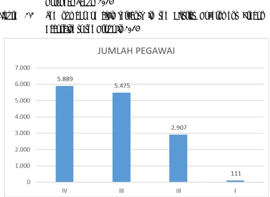
Year 2012‐2014 Golongan Banyaknya PNS 2012 2013 2014 (1) (2) (3) (4) IV/d 1 1 1 IV/c 40 47 83 IV/b 504 1.004 1.139 IV/a 6.718 6.049 5.889 III/d 1.255 1.304 1.321 III/c 948 1.072 1.156 III/b 1.187 1.442 1.346 III/a 1.442 1.237 1.652 II/d 479 663 569 II/c 828 747 739 II/b 1.612 1.766 1.356 II/a 1.565 368 243 I/d 123 46 48 I/c 52 9 4 I/b 48 59 59 I/a 16 3 0 Jumlah 16.818 15.817 15.605
Sumber: Badan Kepegawaian, Pendidikan dan Pelatihan Daerah Kabupaten Cirebon
Bab II. Pemerintahan
Gambar 2.2 Banyaknya PNS di Pemerintah Daerah Kabupaten Crebon Menurut Golongan Tahun 2014
Figure 2.2 The number of civil servants in the District Government Crebon
According to the Group in 2014
Sumber : Badan Kepegawaian, Pendidikan dan Pelatihan Daerah Kabupaten Cirebon
Bab II. Pemerintahan
Tabel 2.1.3 Nama‐Nama Desa Yang Berada di Wilayah Kabupaten Cirebon Dirinci
Menurut Kecamatan Tahun 2014
Table 2.1.3 Names of villages in the regency of Cirebon detailed According to the
District in 2014 Kecamatan Desa Satuan Lingkungan Setempat Blok Sensus Dusun RW RT
010 WALED 008 WALED DESA 3 7 14 11
010 WALED 009 WALED KOTA 5 12 35 18
010 WALED 010 MEKARSARI 4 4 17 12
010 WALED 011 WALED ASEM 2 4 12 10
010 WALED 012 AMBIT 4 5 19 24
010 WALED 013 CIUYAH 4 8 27 21
010 WALED 014 GUNUNGSARI 4 4 14 10
010 WALED 015 KARANGSARI 5 5 14 14
010 WALED 016 CIKULAK KIDUL 4 10 39 21
010 WALED 017 CIKULAK 4 7 17 20
010 WALED 018 CIBOGO 3 6 20 16
010 WALED 019 CISAAT 4 6 25 14
J U M L A H 46 78 253 191
011 PASALEMAN 001 TONJONG 4 6 30 19
011 PASALEMAN 002 TANJUNG ANOM 4 8 28 15
011 PASALEMAN 003 CILENGKRANG GIRANG 3 6 19 10
011 PASALEMAN 004 CILENGKRANG 3 6 26 13 011 PASALEMAN 005 PASALEMAN 5 9 25 16 011 PASALEMAN 006 CIGOBANGWANGI 4 7 20 14 011 PASALEMAN 007 CIGOBANG 4 6 23 16 J U M L A H 27 48 171 103 020 CILEDUG 008 LEUWEUNGGAJAH 3 3 19 15 020 CILEDUG 009 TENJOMAYA 4 4 19 15 020 CILEDUG 010 DAMARGUNA 3 3 18 17 020 CILEDUG 011 JATISEENG 4 5 17 14
020 CILEDUG 012 JATISEENG KIDUL 4 12 47 22
020 CILEDUG 013 CILEDUG KULON 3 3 17 18
020 CILEDUG 014 CILEDUG WETAN 6 4 18 16
020 CILEDUG 015 CILEDUG LOR 4 4 16 15
020 CILEDUG 016 CILEDUG TENGAH 3 5 17 17
020 CILEDUG 017 BOJONGNEGARA 5 5 23 17
J U M L A H 39 48 211 166
Bab II. Pemerintahan
Tabel 2.1.3 Nama‐Nama Desa Yang Berada di Wilayah Kabupaten Cirebon Dirinci Menurut Kecamatan Tahun 2014 (Lanjutan)
Table 2.1.3 Names of villages in the regency of Cirebon detailed According to the District in
2014 (Continued) Kecamatan Desa Satuan Lingkungan Setempat Blok Sensus Dusun RW RT 021 PABUARAN 001 SUKADANA 3 9 23 15
021 PABUARAN 002 PABUARAN KIDUL 4 8 29 17
021 PABUARAN 003 PABUARAN WETAN 2 8 32 20
021 PABUARAN 004 PABUARAN LOR 6 14 44 21
021 PABUARAN 005 JATIRENGGANG 3 9 27 12
021 PABUARAN 006 HULUBANTENG 3 6 26 15
021 PABUARAN 007 HULUBANTENG LOR 3 4 18 13
J U M L A H 24 58 199 113
030 LOSARI 009 ASTANALANGGAR 4 8 23 20
030 LOSARI 010 BARISAN 3 6 20 13
030 LOSARI 011 LOSARI KIDUL 4 7 20 14
030 LOSARI 012 PANGGANGSARI 4 8 35 27
030 LOSARI 013 LOSARI LOR 3 6 38 21
030 LOSARI 014 MULYASARI 4 9 31 20
030 LOSARI 015 KALIRAHAYU 12 8 34 27
030 LOSARI 016 KALISARI 3 7 26 29
030 LOSARI 017 AMBULU 5 6 31 25
J U M L A H 46 72 279 218
031 PABEDILAN 001 BABAKAN LOSARI 5 5 15 13
031 PABEDILAN 002 SIDARESMI 5 5 27 11
031 PABEDILAN 003 KALIBUNTU 5 5 18 18
031 PABEDILAN 004 DUKUHWIDARA 5 5 18 20
031 PABEDILAN 005 PASURUAN 5 5 21 22
031 PABEDILAN 006 KALIMUKTI 3 6 21 21
031 PABEDILAN 007 PABEDILAN KALER 3 4 15 18
031 PABEDILAN 008 BABAKAN LOSARI LOR 4 4 22 14
031 PABEDILAN 009 PABEDILAN KIDUL 3 6 20 25
031 PABEDILAN 010 PABEDILAN KULON 3 5 25 18
031 PABEDILAN 011 PABEDILAN WETAN 2 3 13 15
031 PABEDILAN 012 TERSANA 2 2 11 13
031 PABEDILAN 013 SILIHASIH 2 4 10 13
J U M L A H 47 59 236 221
Bab II. Pemerintahan
Tabel 2.1.3 Nama‐Nama Desa Yang Berada di Wilayah Kabupaten Cirebon Dirinci Menurut Kecamatan Tahun 2014 (Lanjutan)
Table 2.1.3 Names of villages in the regency of Cirebon detailed According to the District in 2014
(Continued) Kecamatan Desa Satuan Lingkungan Setempat Blok Sensus Dusun RW RT 040 BABAKAN 001 CANGKUANG 6 6 30 22
040 BABAKAN 002 SERANG WETAN 4 4 16 17
040 BABAKAN 003 BOJONGGEBANG 4 4 17 16
040 BABAKAN 004 KUDUKERAS 3 4 12 17
040 BABAKAN 005 SUMBER KIDUL 3 4 16 17
040 BABAKAN 006 KUDUMULYA 2 5 12 13
040 BABAKAN 007 SUMBER LOR 5 3 11 14
040 BABAKAN 008 BABAKAN 5 9 21 13
040 BABAKAN 009 PAKUSAMBEN 5 5 24 14
040 BABAKAN 010 KARANGWANGUN 4 8 28 27
040 BABAKAN 011 BABAKAN GEBANG 5 9 23 26
040 BABAKAN 012 GEMBONGAN 3 6 18 18
040 BABAKAN 013 SERANG KULON 3 5 18 15
040 BABAKAN 014 GEMBONGAN MEKAR 4 4 17 23
J U M L A H 56 76 263 252
041 GEBANG 001 DOMPYONG KULON 3 4 16 17
041 GEBANG 002 DOMPYONG WETAN 3 6 26 13
041 GEBANG 003 KALIMEKAR 3 6 12 11
041 GEBANG 004 KALIMARO 3 7 16 15
041 GEBANG 005 GAGASARI 3 3 9 17
041 GEBANG 006 KALIPASUNG 4 8 19 11
041 GEBANG 007 GEBANG KULON 7 14 35 22
041 GEBANG 008 GEBANG 5 6 23 20
041 GEBANG 009 GEBANG UDIK 4 8 50 21
041 GEBANG 010 GEBANG ILIR 5 5 13 19
041 GEBANG 011 GEBANG MEKAR 4 6 18 23
041 GEBANG 012 PELAYANGAN 2 4 17 18
041 GEBANG 013 MELAKASARI 2 4 10 10
J U M L A H 48 81 264 217
Bab II. Pemerintahan
Tabel 2.1.3 Nama‐Nama Desa Yang Berada di Wilayah Kabupaten Cirebon Dirinci Menurut Kecamatan Tahun 2014 (Lanjutan)
Table 2.1.3 Names of villages in the regency of Cirebon detailed According to the District in
2014 (Continued) Kecamatan Desa Satuan Lingkungan Setempat Blok Sensus Dusun RW RT 050 KARANGSEMBUNG 008 TAMBELANG 2 2 12 12 050 KARANGSEMBUNG 015 KARANGSUWUNG 3 9 22 24 050 KARANGSEMBUNG 016 KARANGTENGAH 3 7 21 12 050 KARANGSEMBUNG 017 KALIMEANG 6 6 23 12 050 KARANGSEMBUNG 018 KARANGMALANG 5 10 27 13 050 KARANGSEMBUNG 019 KARANGMEKAR 5 12 25 18 050 KARANGSEMBUNG 020 KUBANGKARANG 5 10 31 13 050 KARANGSEMBUNG 021 KARANGSEMBUNG 4 7 18 16 J U M L A H 33 63 179 120 051 KARANGWARENG 001 SEUSEUPAN 2 4 9 12 051 KARANGWARENG 002 SUMURKONDANG 2 4 12 12 051 KARANGWARENG 003 JATIPIRING 2 4 10 7 051 KARANGWARENG 004 KUBANGDELEG 6 12 30 21 051 KARANGWARENG 005 KARANGANYAR 2 5 20 14 051 KARANGWARENG 006 KARANGWANGI 3 4 15 14 051 KARANGWARENG 007 BLENDER 5 10 20 21 051 KARANGWARENG 008 KARANGWARENG 3 8 19 12 051 KARANGWARENG 009 KARANGASEM 2 5 18 13 J U M L A H 27 56 158 126 060 LEMAHABANG 005 PICUNGPUGUR 5 2 11 6 060 LEMAHABANG 006 LEUWIDINGDING 2 6 12 8 060 LEMAHABANG 007 ASEM 5 5 14 14
060 LEMAHABANG 013 CIPEUJEUH KULON 5 5 28 21
060 LEMAHABANG 014 SINDANGLAUT 3 5 19 14
060 LEMAHABANG 015 CIPEUJEUH WETAN 4 5 17 29
060 LEMAHABANG 016 LEMAHABANG KULON 3 8 26 17
060 LEMAHABANG 017 LEMAHABANG 3 6 22 12
060 LEMAHABANG 018 SIGONG 5 11 37 23
060 LEMAHABANG 019 SARAJAYA 4 10 33 17
060 LEMAHABANG 020 TUK KARANGSUWUNG 3 6 12 9
060 LEMAHABANG 021 BELAWA 4 6 24 20
060 LEMAHABANG 022 WANGKELANG 5 5 15 8
J U M L A H 51 80 270 198
Bab II. Pemerintahan
Tabel 2.1.3 Nama‐Nama Desa Yang Berada di Wilayah Kabupaten Cirebon Dirinci Menurut Kecamatan Tahun 2014 (Lanjutan)
Table 2.1.3 Names of villages in the regency of Cirebon detailed According to the District in
2014 (Continued) Kecamatan Desa Satuan Lingkungan Setempat Blok Sensus Dusun RW RT
061 SUSUKAN LEBAK 001 KARANGMANGGU 5 6 21 15
061 SUSUKAN LEBAK 002 KALIGAWE 3 6 17 15
061 SUSUKAN LEBAK 003 KALIGAWE WETAN 2 6 15 11
061 SUSUKAN LEBAK 004 CURUG WETAN 2 4 16 15
061 SUSUKAN LEBAK 005 CURUG 2 4 16 16
061 SUSUKAN LEBAK 006 WILULANG 2 2 5 6
061 SUSUKAN LEBAK 007 SUSUKAN AGUNG 2 6 17 10
061 SUSUKAN LEBAK 008 SUSUKAN LEBAK 2 4 19 12
061 SUSUKAN LEBAK 009 SUSUKAN TONGGOH 5 6 11 8
061 SUSUKAN LEBAK 010 SAMPIH 2 5 10 12
061 SUSUKAN LEBAK 011 PASAWAHAN 0 2 5 6
061 SUSUKAN LEBAK 012 CIAWI ASIH 3 6 28 20
061 SUSUKAN LEBAK 013 CIAWIJAPURA 3 7 27 19
J U M L A H 33 64 207 165
070 SEDONG 001 KARANGWUNI 3 6 32 19
070 SEDONG 002 SEDONG KIDUL 3 8 31 16
070 SEDONG 003 SEDONG LOR 3 6 16 15
070 SEDONG 004 WINDUJAYA 5 5 15 14 070 SEDONG 005 WINDUHAJI 3 2 20 12 070 SEDONG 006 KERTAWANGUN 2 6 26 15 070 SEDONG 007 PANAMBANGAN 3 5 19 16 070 SEDONG 008 PUTAT 4 6 20 17 070 SEDONG 009 PANONGAN 4 6 20 13
070 SEDONG 010 PANONGAN LOR 4 8 19 16
J U M L A H 34 58 218 153
Bab II. Pemerintahan
Tabel 2.1.3 Nama‐Nama Desa Yang Berada di Wilayah Kabupaten Cirebon Dirinci Menurut Kecamatan Tahun 2014 (Lanjutan)
Table 2.1.3 Names of villages in the regency of Cirebon detailed According to the District in 2014 (Continued) Kecamatan Desa Satuan Lingkungan Setempat Blok Sensus Dusun RW RT 080 ASTANAJAPURA 004 MUNJUL 9 8 28 29 080 ASTANAJAPURA 005 SIDAMULYA 4 4 18 18
080 ASTANAJAPURA 006 MERTAPADA KULON 8 7 20 17
080 ASTANAJAPURA 007 MERTAPADA WETAN 7 7 27 25
080 ASTANAJAPURA 008 BUNTET 3 7 27 23
080 ASTANAJAPURA 009 KANCI KULON 4 7 25 18
080 ASTANAJAPURA 010 KANCI 4 8 28 22
080 ASTANAJAPURA 011 ASTANAJAPURA 4 8 24 23
080 ASTANAJAPURA 015 KENDAL 4 4 12 13
080 ASTANAJAPURA 016 JAPURA KIDUL 5 9 39 30
080 ASTANAJAPURA 017 JAPURABAKTI 5 8 33 32
J U M L A H 57 77 270 250
081 PANGENAN 001 ASTANAMUKTI 5 4 15 19
081 PANGENAN 002 PANGARENGAN 5 8 16 17
081 PANGENAN 003 JAPURA LOR 5 9 27 30
081 PANGENAN 004 BERINGIN 3 3 11 14 081 PANGENAN 005 RAWAURIP 5 5 18 21 081 PANGENAN 006 BENDUNGAN 4 4 16 14 081 PANGENAN 007 PANGENAN 3 6 20 18 081 PANGENAN 008 GETRAKMOYAN 4 8 48 24 081 PANGENAN 009 ENDER 5 10 32 19 J U M L A H 39 57 203 176 090 MUNDU 001 SETUPATOK 6 6 21 30 090 MUNDU 002 PENPEN 7 5 23 33
090 MUNDU 003 MUNDU MESIGIT 3 6 16 15
090 MUNDU 004 L U W U N G 9 8 17 17
090 MUNDU 005 WARUDUWUR 3 5 11 15
090 MUNDU 006 C I T E M U 2 3 9 11
090 MUNDU 007 BANDENGAN 3 4 12 12
090 MUNDU 008 MUNDU PESISIR 4 8 28 18
090 MUNDU 009 S U C I 3 3 9 14
090 MUNDU 010 BANJARWANGUNAN 7 8 37 37
090 MUNDU 011 PAMENGKANG 8 10 44 34
090 MUNDU 012 SINARRANCANG 4 4 12 13
Bab II. Pemerintahan
Tabel 2.1.3 Nama‐Nama Desa Yang Berada di Wilayah Kabupaten Cirebon Dirinci Menurut Kecamatan Tahun 2014 (Lanjutan)
Table 2.1.3 Names of villages in the regency of Cirebon detailed According to the District in 2014 (Continued)
Kecamatan Desa Satuan Lingkungan Setempat Blok Sensus Dusun RW RT 100 BEBER 001 WANAYASA 2 4 8 6 100 BEBER 002 SINDANGKASIH 2 5 16 13 100 BEBER 003 SINDANGHAYU 2 4 12 9 100 BEBER 004 CIAWIGAJAH 7 12 29 24 100 BEBER 008 CIKANCAS 3 6 18 10 100 BEBER 009 HALIMPU 3 3 12 10 100 BEBER 010 CIPINANG 7 6 19 10 100 BEBER 011 BEBER 5 9 28 19 100 BEBER 012 PATAPAN 5 5 13 11 100 BEBER 013 KONDANGSARI 9 7 20 19 J U M L A H 45 61 175 131 101 GREGED 005 KAMARANG 2 4 11 12 101 GREGED 006 GREGED 5 5 17 12
101 GREGED 007 KAMARANG LEBAK 2 5 11 10
101 GREGED 014 DURAJAYA 3 6 20 15
101 GREGED 015 JATIPANCUR 4 4 12 13
101 GREGED 016 SINDANG KEMPENG 5 5 16 12
101 GREGED 017 NANGGELA 5 2 16 19
101 GREGED 001 GUMULUNG LEBAK 9 6 25 28
101 GREGED 002 LEBAK MEKAR 3 6 26 30
101 GREGED 003 GUMULUNG TONGGOH 4 8 35 26
J U M L A H 42 51 189 177
111 TALUN 001 SAMPIRAN 5 10 26 30
111 TALUN 002 CIPERNA 2 5 19 22
111 TALUN 003 KECOMBERAN 3 7 22 26
111 TALUN 004 CIREBON GIRANG 2 12 56 43
111 TALUN 005 KERANDON 5 4 12 13
111 TALUN 006 WANASABA KIDUL 8 6 24 26
111 TALUN 007 WANASABA LOR 4 5 20 16
111 TALUN 012 CEMPAKA 9 4 16 20 111 TALUN 013 KEPONGPONGAN 4 6 22 19 111 TALUN 014 KUBANG 4 5 12 15 111 TALUN 015 SARWADADI 11 3 10 9 J U M L A H 57 67 239 238
Bab II. Pemerintahan
Tabel 2.1.3 Nama‐Nama Desa Yang Berada di Wilayah Kabupaten Cirebon Dirinci Menurut Kecamatan Tahun 2014 (Lanjutan)
Table 2.1.3 Names of villages in the regency of Cirebon detailed According to the District in 2014 (Continued) Kecamatan Desa Satuan Lingkungan Setempat Blok Sensus Dusun RW RT 120 SUMBER 010 MATANGAJI 3 6 21 13 120 SUMBER 011 SIDAWANGI 4 10 20 20 120 SUMBER 014 BABAKAN * ‐ 5 15 12 120 SUMBER 015 SUMBER * ‐ 9 46 26 120 SUMBER 016 PERBUTULAN * ‐ 5 13 11 120 SUMBER 017 KEMANTREN * ‐ 6 17 12 120 SUMBER 018 SENDANG * ‐ 5 21 11 120 SUMBER 019 GEGUNUNG * ‐ 4 13 12 120 SUMBER 020 PEJAMBON * ‐ 5 17 11 120 SUMBER 021 WATUBELAH * ‐ 6 18 19 120 SUMBER 022 PASALAKAN * ‐ 5 20 22 120 SUMBER 023 KALIWADAS * ‐ 7 22 21 120 SUMBER 024 TUKMUDAL * ‐ 11 51 38 120 SUMBER 025 KENANGA * ‐ 7 25 25 J U M L A H 7 91 319 253 121 DUKUPUNTANG 001 BOBOS 4 8 31 18 121 DUKUPUNTANG 002 CIKALAHANG 5 10 35 23 121 DUKUPUNTANG 003 MANDALA 4 9 36 21 121 DUKUPUNTANG 004 CISAAT 5 10 29 20 121 DUKUPUNTANG 005 SINDANGJAWA 5 5 30 17 121 DUKUPUNTANG 006 SINDANGMEKAR 2 8 27 22 121 DUKUPUNTANG 007 CANGKOAK 8 7 30 20 121 DUKUPUNTANG 008 KEPUNDUAN 2 2 8 7 121 DUKUPUNTANG 009 BALAD 3 3 14 15 121 DUKUPUNTANG 010 DUKUPUNTANG 5 5 15 13 121 DUKUPUNTANG 011 CIPANAS 8 10 33 20 121 DUKUPUNTANG 012 GIRINATA 6 11 19 17
121 DUKUPUNTANG 013 KEDONGDONG KIDUL 2 3 11 14
J U M L A H 59 86 317 227
Bab II. Pemerintahan
Tabel 2.1.3 Nama‐Nama Desa Yang Berada di Wilayah Kabupaten Cirebon Dirinci Menurut Kecamatan Tahun 2014 (Lanjutan)
Table 2.1.3 Names of villages in the regency of Cirebon detailed According to the District in 2014 (Continued) Kecamatan Desa Satuan Lingkungan Setempat Blok Sensus Dusun RW RT 130 PALIMANAN 003 KEPUH 3 3 21 18 130 PALIMANAN 006 CILUKRAK 9 3 12 13 130 PALIMANAN 007 BALERANTE 9 2 12 20 130 PALIMANAN 008 PANONGAN 12 3 26 19 130 PALIMANAN 009 BEBERAN 2 3 12 15 130 PALIMANAN 010 SEMPLO 2 3 14 17
130 PALIMANAN 011 PALIMANAN TIMUR 13 8 23 29
130 PALIMANAN 014 PEGAGAN 4 7 28 33 130 PALIMANAN 015 LUNGBENDA 3 3 16 14 130 PALIMANAN 016 CIAWI 9 ‐ 16 16 130 PALIMANAN 017 CENGKUANG 5 9 24 20 130 PALIMANAN 018 TEGALKARANG 8 8 16 18 J U M L A H 79 52 220 232 140 PLUMBON 006 CEMPAKA 4 7 21 18 140 PLUMBON 007 PAMIJAHAN 2 3 17 22 140 PLUMBON 017 LURAH 6 6 18 17 140 PLUMBON 018 MARIKANGEN 2 7 22 26
140 PLUMBON 019 BODE LOR 4 4 20 19
140 PLUMBON 020 BODESARI 6 4 28 19 140 PLUMBON 021 GOMBANG 3 5 25 18 140 PLUMBON 022 KARANGMULYA 2 4 23 12 140 PLUMBON 023 KARANGASEM 1 5 27 22 140 PLUMBON 024 PLUMBON 2 7 19 14 140 PLUMBON 025 PURBAWINANGUN 2 4 12 9 140 PLUMBON 026 KEBAREPAN 2 8 22 14 140 PLUMBON 027 PASANGGRAHAN 2 5 15 15 140 PLUMBON 028 KEDUNGSANA 2 5 25 16 140 PLUMBON 029 DANAMULYA 4 4 18 11 J U M L A H 44 78 312 252
Bab II. Pemerintahan
Tabel 2.1.3 Nama‐Nama Desa Yang Berada di Wilayah Kabupaten Cirebon Dirinci Menurut Kecamatan Tahun 2014 (Lanjutan)
Table 2.1.3 Names of villages in the regency of Cirebon detailed According to the District in 2014 (Continued) Kecamatan Desa Satuan Lingkungan Setempat Blok Sensus Dusun RW RT 141 DEPOK 001 CIKEDUK 12 4 17 14 141 DEPOK 002 WARUGEDE 5 6 27 16 141 DEPOK 003 KARANGWANGI 3 4 30 19 141 DEPOK 004 GETASAN 14 4 14 13 141 DEPOK 005 KEJUDEN 11 7 20 14 141 DEPOK 006 KEDUANAN 9 4 12 14 141 DEPOK 007 WARUROYOM 2 5 22 13 141 DEPOK 008 WARUKAWUNG 2 5 29 22 141 DEPOK 009 WARUJAYA 6 5 19 18 141 DEPOK 010 DEPOK 7 4 15 12
141 DEPOK 011 KASUGENGAN KIDUL 2 7 18 19
141 DEPOK 012 KASUGENGAN LOR 15 5 20 25
J U M L A H 88 60 240 199
150 WERU 005 KARANGSARI 23 6 36 23
150 WERU 006 KERTASARI 3 6 14 18
150 WERU 007 MEGU CILIK 2 3 15 23
150 WERU 008 MEGU GEDE 2 4 23 23
150 WERU 009 SETU WETAN 2 5 14 16
150 WERU 010 WERU KIDUL 3 7 19 16
150 WERU 011 SETU KULON 4 4 12 20
150 WERU 012 TEGALWANGI 4 8 32 29
150 WERU 015 WERU LOR 2 4 13 21
J U M L A H 45 47 180 189
151 PLERED 001 PANEMBAHAN 0 5 16 13
151 PLERED 002 TRUSMI WETAN 1 5 16 10
151 PLERED 003 TRUSMI KULON 0 4 16 9
151 PLERED 004 SARABAU 2 5 15 15 151 PLERED 005 GAMEL 2 4 15 13 151 PLERED 006 WOTGALI 0 4 13 17 151 PLERED 007 KALIWULU 0 5 26 26 151 PLERED 008 TEGALSARI 0 7 21 32 151 PLERED 009 CANGKRING 2 4 12 16 151 PLERED 010 PANGKALAN 3 4 15 16 J U M L A H 10 47 165 167
Bab II. Pemerintahan
Tabel 2.1.3 Nama‐Nama Desa Yang Berada di Wilayah Kabupaten Cirebon Dirinci Menurut Kecamatan Tahun 2014 (Lanjutan)
Table 2.1.3 Names of villages in the regency of Cirebon detailed According to the District in 2014 (Continued) Kecamatan Desa Satuan Lingkungan Setempat Blok Sensus Dusun RW RT
161 TENGAH TANI 001 PALIR 0 3 12 8
161 TENGAH TANI 002 ASTAPADA 0 4 17 16
161 TENGAH TANI 003 GESIK 0 8 20 17
161 TENGAH TANI 004 KEMLAKAGEDE 0 5 20 19
161 TENGAH TANI 005 DAWUAN 0 7 31 23
161 TENGAH TANI 006 BATTEMBAT 0 4 24 16
161 TENGAH TANI 007 KALIBARU 0 6 24 19
161 TENGAH TANI 008 KALITENGAH 0 6 14 14
J U M L A H 0 43 162 132 162 KEDAWUNG 001 KALIKOA 0 8 30 17 162 KEDAWUNG 002 KEDUNGDAWA 0 5 28 18 162 KEDAWUNG 003 TUK 0 8 34 24 162 KEDAWUNG 004 KEDUNGJAYA 0 10 47 29 162 KEDAWUNG 005 KEDAWUNG 0 6 33 16 162 KEDAWUNG 006 KERTAWINANGUN 0 6 27 29 162 KEDAWUNG 007 SUTAWINANGUN 0 8 49 34 162 KEDAWUNG 008 PILANGSARI 0 6 23 17 J U M L A H 0 57 280 184
171 GUNUNG JATI 001 ADIDHARMA 0 6 21 15
171 GUNUNG JATI 002 PASINDANGAN 0 5 17 18
171 GUNUNG JATI 003 JADIMULYA 0 6 27 19
171 GUNUNG JATI 004 KLAYAN 0 6 27 26
171 GUNUNG JATI 005 JATIMERTA 2 4 17 12
171 GUNUNG JATI 006 ASTANA 2 4 14 8
171 GUNUNG JATI 007 KALISAPU 6 7 14 9
171 GUNUNG JATI 008 WANAKAYA 0 4 15 15
171 GUNUNG JATI 009 GROGOL 8 6 25 12
171 GUNUNG JATI 010 BABADAN 0 4 12 14
171 GUNUNG JATI 011 BUYUT 6 10 29 17
171 GUNUNG JATI 012 MAYUNG 2 4 16 11
171 GUNUNG JATI 013 SAMBENG 3 6 18 11
171 GUNUNG JATI 014 SIRNABAYA 6 7 27 11
171 GUNUNG JATI 015 MERTASINGA 0 6 18 17
J U M L A H 35 85 297 215
Bab II. Pemerintahan
Tabel 2.1.3 Nama‐Nama Desa Yang Berada di Wilayah Kabupaten Cirebon Dirinci Menurut Kecamatan Tahun 2014 (Lanjutan)
Table 2.1.3 Names of villages in the regency of Cirebon detailed According to the District in 2014 (Continued)
Kecamatan Desa Satuan Lingkungan Setempat Blok Sensus Dusun RW RT 180 KAPETAKAN 010 BUNGKO 4 5 22 17 180 KAPETAKAN 011 KERTASURA 3 12 26 28
180 KAPETAKAN 012 PEGAGAN KIDUL 4 4 18 21
180 KAPETAKAN 015 PEGAGAN LOR 0 8 25 27
180 KAPETAKAN 016 DUKUH 4 8 20 15
180 KAPETAKAN 017 KARANGKENDAL 4 7 25 23
180 KAPETAKAN 018 GROGOL 4 6 24 22
180 KAPETAKAN 019 KAPETAKAN 7 6 28 24
180 KAPETAKAN 020 BUNGKO LOR 4 4 22 14
J U M L A H 34 60 210 191
181 SURANENGGALA 001 SURANENGGALA KULON 4 4 14 20
181 SURANENGGALA 002 SURAKARTA 5 7 24 19
181 SURANENGGALA 003 KERATON 2 5 19 17
181 SURANENGGALA 004 PURWAWINANGUN 8 8 38 32
181 SURANENGGALA 005 MUARA 3 7 25 14
181 SURANENGGALA 006 KARANGREJA 4 4 13 13
181 SURANENGGALA 007 SURANENGGALA KIDUL 5 5 21 14
181 SURANENGGALA 008 SURANENGGALA LOR 4 7 15 15
181 SURANENGGALA 009 SURANENGGALA 4 8 18 19 J U M L A H 39 55 187 163 190 KLANGENAN 001 SERANG 2 8 17 18 190 KLANGENAN 002 KLANGENAN 6 7 24 22 190 KLANGENAN 003 DANAWINANGUN 12 8 16 29 190 KLANGENAN 007 PEKANTINGAN 8 6 14 21
190 KLANGENAN 008 JEMARAS KIDUL 7 4 20 22
190 KLANGENAN 009 JEMARAS LOR 3 3 18 25
190 KLANGENAN 011 SLANGIT 5 8 16 21
190 KLANGENAN 012 KREYO 5 10 20 22
190 KLANGENAN 013 BANGODUA 10 8 16 20
J U M L A H 58 62 161 200
Bab II. Pemerintahan
Tabel 2.1.3 Nama‐Nama Desa Yang Berada di Wilayah Kabupaten Cirebon Dirinci Menurut Kecamatan Tahun 2014 (Lanjutan)
Table 2.1.3 Names of villages in the regency of Cirebon detailed According to the District in 2014 (Continued) Kecamatan Desa Satuan Lingkungan Setempat Blok Sensus Dusun RW RT 191 JAMBLANG 004 JAMBLANG 6 9 38 18 191 JAMBLANG 005 SITIWINANGUN 5 10 30 13 191 JAMBLANG 006 WANGUNHARJA 8 8 10 17
191 JAMBLANG 014 BOJONG WETAN 9 6 24 15
191 JAMBLANG 015 BOJONG LOR 6 9 27 12
191 JAMBLANG 016 ORIMALANG 2 4 22 11
191 JAMBLANG 017 BAKUNG KIDUL 2 10 46 19
191 JAMBLANG 018 BAKUNG LOR 6 10 46 19
J U M L A H 44 66 251 124
200 ARJAWINANGUN 001 SENDE 4 4 18 14
200 ARJAWINANGUN 002 JUNGJANG WETAN 4 4 17 24
200 ARJAWINANGUN 010 JUNGJANG 6 13 52 32
200 ARJAWINANGUN 011 ARJAWINANGUN 4 13 28 27
200 ARJAWINANGUN 012 TEGALGUBUG 5 10 34 37
200 ARJAWINANGUN 013 RAWAGATEL 3 4 8 6
200 ARJAWINANGUN 014 TEGALGUBUG LOR 5 8 26 38
200 ARJAWINANGUN 015 KARANGSAMBUNG 3 3 18 16 200 ARJAWINANGUN 016 BULAK 2 2 7 9 200 ARJAWINANGUN 017 GEYONGAN 5 5 13 15 200 ARJAWINANGUN 018 KEBONTURI 3 4 17 14 J U M L A H 44 70 238 232 201 PANGURAGAN 001 KALIANYAR 0 7 29 15
201 PANGURAGAN 002 PANGURAGAN KULON 0 6 22 26
201 PANGURAGAN 003 PNGURANGAN WETAN 0 5 10 26
201 PANGURAGAN 004 PANGURAGAN LOR 0 5 12 18
201 PANGURAGAN 005 PANGURAGAN 6 10 31 26 201 PANGURAGAN 006 LEMAHTAMBA 0 4 8 13 201 PANGURAGAN 007 GUJEG 0 8 16 18 201 PANGURAGAN 008 KARANGANYAR 0 2 10 13 201 PANGURAGAN 009 KROYA 0 3 10 12 J U M L A H 6 50 148 167
Bab II. Pemerintahan
Tabel 2.1.3 Nama‐Nama Desa Yang Berada di Wilayah Kabupaten Cirebon Dirinci Menurut Kecamatan Tahun 2014 (Lanjutan)
Table 2.1.3 Names of villages in the regency of Cirebon detailed According to the District in 2014 (Continued)
Kecamatan Desa Satuan Lingkungan Setempat Blok Sensus Dusun RW RT 210 CIWARINGIN 004 CIWARINGIN 5 5 21 22 210 CIWARINGIN 005 BABAKAN 6 6 14 23 210 CIWARINGIN 006 BUDUR 5 5 28 19 210 CIWARINGIN 007 GINTUNGRANJENG 9 7 13 19
210 CIWARINGIN 008 GINTUNG KIDUL 10 7 22 24
210 CIWARINGIN 009 GINTUNG TENGAH 3 4 13 13
210 CIWARINGIN 010 BRINGIN 4 4 21 21 210 CIWARINGIN 011 GALAGAMBA 3 8 16 18 J U M L A H 45 46 148 159 211 GEMPOL 001 CUPANG 3 4 12 12 211 GEMPOL 002 CIKEUSAL 2 3 16 13 211 GEMPOL 003 WALAHAR 3 4 13 15
211 GEMPOL 004 PALIMANAN BARAT 4 15 58 45
211 GEMPOL 005 GEMPOL 4 4 15 9 211 GEMPOL 006 KEDUNGBUNDER 7 7 21 25 211 GEMPOL 007 KEMPEK 3 6 19 18 211 GEMPOL 008 WINONG 7 7 29 37 J U M L A H 33 50 183 174 220 SUSUKAN 001 TANGKIL 8 5 24 24 220 SUSUKAN 002 WIYONG 6 6 20 21 220 SUSUKAN 003 KEDONGDONG 4 8 33 36
220 SUSUKAN 004 GINTUNG LOR 3 4 19 23
220 SUSUKAN 005 BOJONG KULON 5 6 30 33
220 SUSUKAN 006 KEJIWAN 5 10 40 23
220 SUSUKAN 007 SUSUKAN 5 5 32 26
220 SUSUKAN 008 LUWUNG KENCANA 5 6 17 18
220 SUSUKAN 009 BUNDER 7 6 12 11 220 SUSUKAN 010 JATIPURA 2 2 7 9 220 SUSUKAN 011 UJUNGGEBANG 4 12 33 29 220 SUSUKAN 012 JATIANOM 6 6 15 17 J U M L A H 60 76 282 270
Bab II. Pemerintahan
Tabel 2.1.3 Nama‐Nama Desa Yang Berada di Wilayah Kabupaten Cirebon Dirinci Menurut Kecamatan Tahun 2014 (Lanjutan)
Table 2.1.3 Names of villages in the regency of Cirebon detailed According to the District in 2014 (Continued) Kecamatan Desa Satuan Lingkungan Setempat Blok Sensus Dusun RW RT
230 GEGESIK 007 BAYALANGU KIDUL 5 10 35 23
229 GEGESIK 008 BAYALANGU LOR 5 5 20 21
230 GEGESIK 009 KEDUNGDALEM 3 8 25 22
230 GEGESIK 010 PANUNGGUL 3 9 33 13
230 GEGESIK 011 GEGESIK WETAN 5 15 30 14
230 GEGESIK 012 GEGESIK KIDUL 5 13 48 16
230 GEGESIK 016 SLENDRA 4 8 18 14
230 GEGESIK 017 JAGAPURA KIDUL 4 8 29 29
230 GEGESIK 018 GEGESIK LOR 3 7 16 13
230 GEGESIK 019 GEGESIK KULON 4 11 43 18
230 GEGESIK 020 JAGAPURA WETAN 17 9 29 27
230 GEGESIK 021 JAGAPURA KULON 3 9 40 23
230 GEGESIK 022 JAGAPURA LOR 4 8 31 29
230 GEGESIK 023 SIBUBUT 2 4 14 17
J U M L A H 67 124 411 279
231 KALIWEDI 001 KALIDERES 3 9 27 11
231 KALIWEDI 002 PRAJAWINANGUN WETAN 3 8 36 20
231 KALIWEDI 003 PRAJAWINANGUN KULON 2 2 10 11
231 KALIWEDI 004 KALIWEDI KIDUL 3 8 17 17
231 KALIWEDI 005 KALIWEDI LOR 2 9 27 18
231 KALIWEDI 006 UJUNGSEMI 5 10 36 16
231 KALIWEDI 007 WARGABINANGUN 4 8 29 15
231 KALIWEDI 008 GUWA KIDUL 4 8 25 22
231 KALIWEDI 009 GUWA LOR 3 16 47 20
J U M L A H 29 78 254 150
Bab III. Penduduk dan Transmigrasi
Bab III. Penduduk dan Transmigrasi
PENDUDUK DAN TRANSMIGRASI
3.1 Penduduk
Kabupaten Cirebon adalah salah satu di antara kabupaten‐kabupaten di Propinsi Jawa Barat yang mempunyai jumlah penduduk cukup besar. Penduduk Kabupaten Cirebon pada Tahun 2014 adalah sebanyak 2.293.397 jiwa dan dengan luas wilayah administratif 990,36
Km2 maka rata‐rata kepadatan penduduk di wilayah Kabupaten Cirebon adalah sebesar 2.316
jiwa per Km2.
kota kecamatan dan daerah perkotaan, dimana banyak terdapat kegiatan‐kegiatan ekonomi masyarakat di berbagai bidang usaha yang dapat memberikan lapangan pekerjaan seperti perdagangan, industri, pengangkutan, pertanian, pertambangan, pemerintahan, jasa‐ jasa dan lain‐lain.
Dari total penduduk sebanyak 2.293.397 jiwa, 1.139.263 jiwa diantaranya adalah perempuan sehingga sex rasionya adalah 101,31.
Persebaran penduduk Kabupaten Cirebon per Kecamatan hingga pada Tahun 2014 masih menunjukkan kondisi kurang merata seperti pada tahun‐tahun sebelumnya. Penduduk terbesar terdapat di Kecamatan Sumber yaitu sebanyak 86.313 jiwa dengan sebaran/distribusi penduduknya sebesar 3,76 % dan yang terkecil adalah Kecamatan Pasaleman dengan jumlah penduduk hanya 28.217 jiwa (sebaran penduduk sebesar 1,23 %). Kepadatan penduduk di masing‐masing Kecamatan juga menunjukkan ketidakmerataan. Hal ini disebabkan kondisi dan potensi masing‐masing wilayah kecamatan yang tidak sama. Makin padatnya penduduk cenderung di pusat
3.2 Transmigrasi
Dalam rangka turut meningkatkan pemerataan penduduk di Indonesia pada Tahun 2014, pemerintah kabupaten Cirebon melalui Dinas Tenaga Kerja dan Transmigrasi Kabupaten Cirebon telah mengirimkan sebanyak 20 KK (78 jiwa).
Bab III. Penduduk dan Transmigrasi
POPULATION
AND
TRANSMIGRATION
3.1 POPULATION
Cirebon is one of the districts in West Java which has a population large enough. Cirebon population in 2014 was as much as 2,293,397 inhabitants and the administrative area of 990.36 km2, the average density of population in the district of Cirebon is equal to 2,316 inhabitants per km2.
City districts and urban areas, where there are many economic activities in various fields of business community which can provide jobs such as trade, industry, transport, agriculture, mining, government, services and others.
Of the total population of 2,293,397 people, 1,139,263 inhabitants are women so that sex ratio is 101.31.
Population distribution per Subdistrict Cirebon up in 2014 still shows uneven conditions as in previous years. There biggest population in the District Resource as many as 86 313 inhabitants with a distribution / distribution of the population at 3.76% and the smallest is the District Pasaleman with a population of only 28 217 inhabitants (population distribution of 1.23%).
Population density in each sub‐district also showed inequality. This is due to the conditions and potential of each of the districts are not the same. The more dense the population tends in the center.
3.2 TRANSMIGRATION
In order to contribute to improving the population distribution in Indonesia in 2014, Cirebon district government through the Department of Manpower and Transmigration Cirebon has sent as many as 20 families (78 people).
Bab III. Penduduk dan Transmigrasi Gambar 3. 3 Pet a Jumla h Pe nd ud uk Kabu paten Cirebon per Kecamatan Tahu n 20 14 Fi g u re 3. 3 Po p ul at ion Ma p Ci re bon p er sub -d istr ict in 20 14
Bab III. Penduduk dan Transmigrasi Gambar 3. 4 Pet a Jumla h Keluarga Per Kecamatan di Wilayah Kabupate n Cir e bon Ta hu n 20 14 Fi gu re 3. 4: Ma p of Tot al Fa m il y Per Di st ri ct s i n C ire b o n re genc y i n 2 014
Bab III. Penduduk dan Transmigrasi Gambar 3. 5 Pet a Perse n tase Rumahtangg a Klasifikasi Sej ah te ra 3 atau Lebi h Per Keca matan di Kabupate n Cir e bon Ta hu n 20 14 Fi gu re 3. 5 Perc ent age o f Ho us ehol ds Ma p P rosp er ous C lass ifi cat ion 3 or Mo re Per Di st ri ct i n C ireb o n i n 2 014
Bab III. Penduduk dan Transmigrasi Gambar 3. 6 Pet a Perse n tase Pendu du k Pern ah Kawin di Kabu paten Cirebon Tah u n 20 14 Fi g u re 3. 6: Ma p of Perce n ta g e of Po p u lation Ev er M arried in Cireb o n
Bab III. Penduduk dan Transmigrasi Tabel 3.1.1 Jumlah Penduduk Menurut Jenis Kelamin, Sex Rasio dan Persebaran Penduduk
di Kabupaten Cirebon Tahun 2014
Table 3.1.1 Population by Sex, Sex Ratio and Distribution of Population in Cirebon Regency Year 2014
Kecamatan Penduduk Sebaran/
Distribusi (%)
Kode Nama Laki‐laki Perempuan Jumlah Sex Rasio
(1) (2) (3) (4) (5) (6) (7) 010 Waled 30,215 29,839 60,054 101.26 2.56 011 Pasaleman 23,106 22,577 45,683 102.34 1.95 020 Ciledug 32,211 31,830 64,041 101.20 2.73 021 Pabuaran 31,355 31,132 62,487 100.72 2.66 030 Losari 38,380 39,263 77,643 97.75 3.31 031 Pabedilan 19,192 18,805 37,997 102.06 1.62 040 Babakan 28,200 27,202 55,402 103.67 2.36 041 Gebang 21,042 20,665 41,707 101.82 1.78 050 Karangsembung 22,759 21,706 44,465 104.85 1.90 051 Karangwareng 40,350 39,382 79,732 102.46 3.40 060 Lemahabang 22,665 22,400 45,065 101.18 1.92 061 Susukan Lebak 38,449 36,026 74,475 106.73 3.17 070 Sedong 21,697 21,455 43,152 101.13 1.84 080 Astanajapura 35,881 32,810 68,691 109.36 2.93 081 Pangenan 43,373 42,850 86,223 101.22 3.68 090 Mundu 32,889 31,904 64,793 103.09 2.76 100 Beber 31,848 31,572 63,420 100.87 2.70 101 Greged 39,722 39,556 79,278 100.42 3.38 111 Talun 34,928 31,992 68,850 109.42 2.85 120 Sumber 44,809 45,199 90,008 99.14 3.84 121 Dukupuntang 38,514 38,035 76,549 101.26 3.26 130 Palimanan 29,426 29,895 59,321 98.43 2.53 140 Plumbon 29,204 28,107 57,311 103.90 2.44 141 Depok 34,803 36,956 71,759 94.17 3.06 150 Weru 26,026 26,008 52,034 100.07 2.22 151 Plered 20,493 20,707 41,200 98.97 1.76 161 Tengah Tani 38,340 38,728 77,068 99.00 3.29 162 Kedawung 41,050 40,772 81,822 100.68 3.49 171 Gunungjati 22,383 22,499 44,882 99.48 1.91 180 Kapetakan 33,201 32,162 65,363 103.23 2.79 181 Suranenggala 33,546 32,188 66,734 101.08 2.84 190 Klangenan 14,345 14,265 28,610 100.56 1.22 191 Jamblang 19,218 18,555 37,773 103.57 1.61 200 Arjawinangun 15,925 15,459 31,384 103.01 1.34 201 Panguragan 20,638 19,714 40,352 104,69 1.72 210 Ciwaringin 28,134 25,853 56,987 97.51 2.43 211 Gempol 23,846 24,147 47,993 98.75 2.05 220 Susukan 29,702 28,599 58,301 103.86 2.49 230 Gegesik 27,968 28,436 56,404 98.35 2.40 231 Kaliwedi 21,644 21,253 42,897 101.84 1.83 Kabupaten 1,181,477 1,160,506 2,347,910 103.29 100.0