Preliminary Assessment of Coastal
M a n a g ement Initiati ves in Zanzibar
Farhat Mbarouk, Jeremiah Daffa, Tom Bayer and Siddharth Kamalia
ICM Technical Group
2003
Working Document: 5076TCMP
A joint initiative between the National Environment Management Council, the University of Rhode Island/Coastal ResourcesCenter and the United States Agency for International Developement
1.0 INTRODUCTION
The Zanzibar archipelago comprises of two main Islands, Unguja and Pemba, and 50 other smaller islets. Some of the smaller islands are habitable while most are devoid of human settlements. Unguja and Pemba cover 1,464 and 868 sq kms respectively. The islands of Zanzibar are situated between 5-6 degrees South and 40 degrees east in the Indian Ocean. According to the 2002 census the current population is estimated to be around 985,000 people with a distribution of 623,000 and 362,000 for Unguja and Pemba respectively. Table 1 summarizes the population distribution in Unguja and Pemba. The climate of the Islands of Zanzibar is highly influenced by the monsoon wind regime. As for the Island of Unguja the environment is divided into four main ecological zones: the none-arable coral rag land of the east, the deeper fertile soils of the west, the coastal and marine zone and the urban area which lies within the coastal zone.
The coastal region is of critical importance to Zanzibar. Over half of the nation’s population lives in coastal villages and town (Map 1). The coastal zone provides most of the natural resources that its population relies upon for sustenance. Most coastal inhabitants engage in fishing, mangrove woodcutting (for cooking, construction purposes, and sale), subsistence farming, coastal thicket harvesting and livestock keeping. However in order to make ends meet the majority of the inhabit-ants engage in two or more of these activities simultaneously. Furthermore the coastal area has become a focus for the national development program in which tourism and export processing industries are expected to replace cloves as the principal source of foreign earnings. For example, tourist arrivals have been increasing steadily over the years (Table 2) contributing significantly to the country’s GNP.
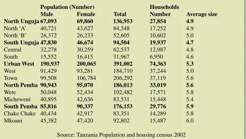
Table 1: Zanzibar: Population Distribution Pattern
Population (Number) Households
Male Female Total Number Average size North Unguja 67,093 69,860 136,953 27,854 4.9
North ‘A’ 40,721 43,627 84,348 17,252 4.9 North ‘B’ 26,372 26,233 52,605 10,602 5.0 South Unguja 47,830 46,674 94,504 19,937 4.7
Central 32,278 30,259 62,537 12,987 4.8
South 15,552 16,415 31,967 6,950 4.6
Urban West 190,937 200,065 391,002 74,363 5.3
West 91,429 93,281 184,710 37,244 5.0
Town 99,508 106,784 206,292 37,119 5.6
North Pemba 90,943 95,070 186,013 33,019 5.6
Wete 50,048 52,434 102,482 17,571 5.8
Micheweni 40,895 42,636 83,531 15,448 5.4 South Pemba 85,816 90,337 176,153 29,776 5.9 Chake Chake 40,434 42,917 83,351 14,289 5.8
Mkoani 45,382 47,420 92,802 15,487 6.0
Major fishing and seaweed farming area.
Realizing the importance of the coastal area to the nation, the status of its resources and the threats they are facing, the Zanzibar government made deliberate efforts to institute appropriate manage-ment measures to ensure sustainable use of coastal resources. These measures were based on integrated management approach. To start with, it laid down the necessary institutional framework that the foundation for Integrated Coastal Management stands on, the National Environmental Policy that was formulated in 1992 and the Environmental Act of 1996. With respect to the man-agement of the coastal zone and its resources, the National Environmental policy aims to “ develop a program of Integrated Coastal Zone Management within the framework of the overall land use plan”. On the other hand, the Environmental Act laid the framework for such coastal management plan. Another legislation, the National Land Use Plan suggested and directed strategic require-ments and options for present and future designation of land for all land activities including those in the coastal area. This is significant since practically all-major tourism infrastructure and facili-ties are located close to the coast (See Figure 3 for the distribution of tourism zones)
Table 2: Tourist arrivals in Zanzibar
Year No. of Tourists
2.0 ADMINISTRATIVE AND GOVERNANCE ISSUES
Zanzibar is part of the United Republic of Tanzania. The union creates a unique political situation, since Zanzibar under the Union Constitution retains a wide range of autonomy in most areas of government and its economy. The Revolutionary Government of Zanzibar deals with matters concerning Zanzibar, whereas the Union Government deals with those in respect to the Tanzania Mainland. The Constitution governing the Union designates only 21 subject areas, including the following: Research, Meteorology, Harbours, Management of the Exclusive Economic Zone, and Mineral Oil Resources. Authority over territorial waters and matters of natural resource manage-ment are within Zanzibar’s exclusive jurisdiction.
Zanzibar Islands have five administrative regions: Urban West, Zanzibar North, Zanzibar South, Pemba North, and Pemba South. The regions are sub-divided into districts, constituencies, wards and “Shehias”. As such the administrative structure of government is well established up to the local level.
There are many national ministries that are mandated to manage some components of marine and coastal resources and the environmental issues. The main ones are:
· Ministry of Agriculture, Natural Resources, Environment and Co-operatives · Department of Environment
· Department of Fisheries
· Ministry responsible for Transport
· Ministry of State for Regional Administration
Governance for Tanzania’s coastal zone is complicated by the existence of two national jurisdic-tions - The Zanzibar Government and The Union Government. Whereas certain issues such as home affairs (law enforcement) and foreign affairs are under joint responsibility of the Union Government, most of the coastal and marine management issues are non-union matters. The adoption of the Territorial Sea and Exclusive Economic Zone Act (1989) invested substantial powers for the control of coastal resources in the Ministry of Foreign Affairs. The Ministry is responsible for the development of the necessary framework for an integrated marine policy, but because of the diverse nature of the coastal zone, progress is slow.
RESEARCH INSTITUTIONS:
Policy and management of coastal resources and environment in Zanzibar is to be informed and advised by Research and Development institutions. The role and function of these institutions are specified in the acts establishing them.
Institute of Marine Sciences (IMS) is fully devoted to marine and coastal research and has the following objectives:
· provide postgraduate training
· provide advisory and consultancy services in marine affairs COASTAL LEGISLATIONS
The key legislation relevant to marine and coastal environment of Zanzibar are presented below: Institutional:
· The Act establishing COLE (1988) help in solving the problem of management of the coastal resources including land.
· The Investment Promotion Act (1986) requires investors to minimise pollution ‘by providing acceptable sewage disposal arrangement and ensure that the chemical, biological substances and agents under their control are without risk to health.
· The Zanzibar Nature Conservation Trust (ZNCT) supports the government in undertaking conservation activities through formal agreements.
· Administrative authorities act 1981. Land use:
· The Land (Distribution) Decree (1966) makes any grant of land conditional upon good hus-bandry and soil conservation.
· Land Alienation Decree (Cap. 94).
· Town and Country Planning Decree (Cap. 85) requires that town plans be adhered to. Prohibits construction close to the beaches since this can block access, spoil the scenery, degrade the beach, cause problems of noise and destabilise the beach.
· Public Land Decree (Cap. 93) Removal of Natural Produce Rules deals with collection of stones, sand, gravel and rocks that require a permit.
Natural resources:
· Forest Reserve Decree (Cap. 120) and woodcutting Decree (Cap. 121) are for the establishment of forest reserves, protection and management of forest and bush.
· Wild Animals Protection Decree (Cap. 128) deals with protection of wildlife species of Zanzi-bar (the green turtle and marine mammals).
· The Wild Birds Protection Decree (Cap. 129) prohibits hunting and trade of many bird species throughout the year, but allows hunting from 1st October to 31st March.
· The Fisheries Legislation (Revised 1988) deals with marine parks, sanctuaries, and controlled areas which may be created by order, pollution prevention, prevention on dynamiting, control on spear fishing and beach seining, sea life including corals, shells, trade and export.
Environment:
· The Towns Act (Cap. 799) covers drainage and sewage disposal and it was repealed in 1986 by the enactment on the Local Government Act.
· Dangerous Goods Act (Cap. 160) covers toxic chemicals, and also governs the port handling, movement and storage of explosives and corrosive or inflammable substances.
· Road Traffic Decree (Cap. 135) deals with air pollution. It has a general provision against vehicles emitting avoidable smoke and visible vapour.
· The Petroleum Act of 1980 concerns exploration and production of petroleum on the seabed ad subsoil of the continental shelf.
· The Mining Act of 1979 regulates mining on land and land beneath the territorial waters and the continental shelf.
Key Legal instruments in Coastal Area Management in Zanzibar
The Environmental Act of 1996 provides a legal basis for the establishment of ICM in Zanzibar. As a result of the sectoral management approach, there are different legislation and acts that influence coastal resource management in Zanzibar:
¨ Fisheries Act 1988 ¨ Forest Act of 1996
¨ The Town and Country Planning Decree, 1955 ¨ Zanzibar Investment Promotion Act 1986 ¨ The COLE Act of 1989
¨ District and Town Councils Act of 1994
3.0 ICM PROGRAMMES IN ZANZIBAR
Beginning to implement the National Environmental Policy, a pilot program of integrated coastal area management was established in 1994 at the Chwaka Bay–Paje Area. The aim of setting up a pilot ICM activity was to expose coastal zone management practitioners to ICM intricacies, includ-ing planninclud-ing and execution of management plans. The choice of Chwaka Bay-Paje site was inter-esting because it encompasses nearly all the coastal zone management issues that are found around the Zanzibar coast. It is a multi use zone that includes tourism development, fisheries, aquaculture, activities that have led to user conflicts.
The Chwaka Bay-Paje pilot project was the first ICM initiative and other Integrated Coastal Man-agement (ICM) projects and Marine Protected Areas (MPA) programmes in Zanzibar followed it. Current ICM projects are: Jozani Chwaka Bay Conservation Project, Menai Bay Conservation Area, Misali Island Conservation Area, Chumbe Island Coral Sanctuary and Mnemba Island Marine Reserve (See Fig 4). These coastal management initiatives are at different levels of imple-mentation. Apart from the major programs, there are several community base organizations that are involved in one way or another in the conservation of marine resources in Zanzibar. Two such projects are located in Muuongoni and Tumbatu (JEMA)
Table 3: Coastal Programmes and their management category in Zanzibar
COSTAL PROGRAMME MANAGEMENT CATEGORY Chwaka Bay-Paje Area ICM
Jozani- Chwaka Bay Conservation Area In the process of becoming a National Park
Menai Bay Conservation Area MPA
Misali Island Conservation Area MPA
Chumbe Island Coral Park Private Nature Reserve
Mnemba Island Conservation Area MPA
THE CHWAKA BAY-PAJE AREA
Peninsula as far south as Paje. There are seven small villages in the area with a total population of about 10,3000. These villages are Chwaka, Uroa, Michamvi, Bwejuu, Paje, Ukongoroni, Marumbi and Charawe. The Chwaka-Bay Paje initiative was started with the aim of building momentum towards national ICAM (Integrated Coastal Area Management) and to develop necessary experi-ence in coastal management. The Chwaka Bay-Paje Area was chosen as a demonstration area for a number of reasons:
Ø The Chwaka Bay-Paje coastal resources are important both at the local and national level for fisheries, tourism, seaweed farming and coastal thicket and mangrove harvests. Ø The area is confronted by most of the critical coastal issues that area found in Zanzibar.
For example, it faces a rapidly expanding international tourism industry within an area comprised of traditional villages and societies, thus posing a threat of conflicts between tourism and local cultural values. Consequently, the program managers felt that manage-ment approaches and techniques developed here could be useful to other areas.
Ø Another major impetus in the selection of the area was that eminent local people recog-nized that changes were occurring and that problems would arise unless necessary actions were taken in full consultation with local people.
The management objectives of the project were to:
Ø Maintain the coastal resources base on which the economy depends Ø Sustain and enhance village economies
Ø Encourage environmentally and culturally sensitive tourism development within the area which benefits both the local residents and the nation.
Ø Foster harmonious relationships between and among non-traditional and traditional activi-ties
Ø Utilize and build, upon existing laws, policies, regulations, institutions and experience to achieve ICAM goals and objectives
The program was carried out by an Interagency planning team lead by the Department of Environ-ment and consisting of individuals from the Sub-Commissions of fisheries and forestry, Commis-sion for Lands and Environment, and the Institute of Marine Sciences. The program was supported by and received technical assistance from the United Nations Environmental Program, East Afri-can Regional Seas Program, Priority Action Program/Regional Activity Center (PAP/RAC), Food and Agriculture Organization of the United Nations (FA0), Regional Economic Development Support Office for East and Southern Africa, Center for Environment/Bureau for Global Program, US Agency for International Development and University of Rhode Island Coastal Resource Center. The planning team was involved in collecting and reviewing information and holding consultation meetings with different stakeholders to identify pertinent issues, reach consensus on management objectives and begin to develop strategies to address the coastal management issues of the Chwaka Bay Paje Area.
A final document on the “ Initial Findings for an Action Strategy in the Chwaka Bay-Paje Area” was produced. In the second phase (1999), several activities, such as establishing the Coastal Resources Management Committee (CRMC) for Chwaka Bay- Paje Area, were implemented. The objective behind establishing this committee was to guide all coastal management activities within the area in cooperation with local governments, national agencies and private sector stakeholders. At this stage it was realized that it was important to create the necessary conditions to allow local community members to participate in decisions regarding how the project was being implemented. Community participation was ensured through the formation of CRMC subcommittees on major resource uses (i.e. subcommittees on fisheries, seaweed, tourism, and mangroves). Members of these sub-committees came from within the local communities.
During the implementation, the pilot project achieved the following:
Ø Construction of public toilets in Chwaka and Uroa as part of demonstration activities. Ø Provision of materials for toilet construction to (69) households in Charawe
Ø Installation of Environmental Awareness Banners in different areas of Unguja both in town and in Chwaka-Bay Paje Area.
Ø Formulation of ICM Strategies of Chwaka Bay-Paje Area was carried out by Institution concerned.
JOZANI-CHWAKA BAY CONSERVATION PROJECT (Integrated conservation and devel-opment project)
Conservation efforts at Jozani began in 1990 with a decision by the forestry Department to stop commercial timber harvesting. In 1995 Jozani- Chwaka Bay Conservation Project (JCBCP) was established as a partnership initiative between CARE International in Tanzania, the Department of Commercial Crops, Fruits and Forestry (DCCFF) of the government of Zanzibar, and the commu-nities living near the forest. Jozani–Chwaka Bay Conservation Area (JCBA) is located about 35 kilometers from Stone Town in the southeastern part of Unguja Island. It is the largest area of primary and secondary vegetation on Unguja and it encompasses the only significant natural forest still standing in Zanzibar. The Jozani–Chwaka Bay Conservation Area, with aprotected core area of 56 sqkm and buffer of 80 km2, is the single most important site for the conservation of
Zanzibar’s globally significant biodiversity. Jozani was declared a reserve in 1960 through Forest Reserve Decree of 1955. The longer-term goal of Jozani is to protect the biodiversity of Zanzibar, especially the groundwater forest and associated fauna, while enhancing the living conditions of the people around the protected area.
Jozani is known for its unique plant communities, swamp forest, and large mammal species (Zan-zibar Red Colobus and the Ader’s Duiker). Since 1995 the project has worked closely with villag-ers around Jozani Forest with the aim of conserving its unique and biologically valuable resources. The project works in 16 villages: , Jozani-Chwaka Bay Jozani/Pete, Unguja Ukuu, Charawe, Ukongoroni, Cheju, Kitogani, Muyuni, Muungoni, Michamvi, Jambiani, and Bwejuu. Financial support for the project, which is now ending, has been provided by the Government of Austria; the Global Environment Facility; the Ford Foundation; McKnight Foundation; the Dutch Government; the Bridge Mill Trust; the Joseph Ellis Foundation; UNESCO; CARE Austria; and CARE USA. The Jozani forest and surrounding environs have traditionally provided important resources, particularly timber, building poles, fuel wood, bush meat, and land for shifting agriculture. Com-munities within the Jozani area have been heavily dependent on the forest resources to support themselves. However, local population increase has led to a huge exploitation pressure on the forest resources causing a sharp decline. To stop further decline of the forest’s natural resources, the forest has now been turned into a major tourist attraction with nature trails and mangrove board walks. The area is a growing tourism attraction and has considerable eco-tourism potential.
The communities project activities have in the past included community natural resource planning, support for conservation education, capacity building, and advocacy. Nowadays the communities surrounding Jozani Forest are taking steps to manage their own forests on a sustainable basis and are starting to limit their hunting and wood harvesting.
In the initial phase of the project (1995-1997), training was one of the top priorities. In the second phase (1998-2000) CARE focused on improving the economic wellbeing of the families living around the protected area. The second-phase activities included: developing and implementing a saving and loan scheme, community enterprise development, NGO development, and policy and legislation advocacy.
Jozani –Chwaka Bay as well as enhancing the livelihood security of communities living adjacent to the Jozani-Chwaka Bay Conservation Project.
Furthermore, in 1996, the village coordinating committees around Jozani decided to create an organ to streamline community issues to and from JCBCP. Representatives from the participating village communities and some nominated project staff formed this Advisory Committee. The Committee had 40 representatives altogether. Later, the Advisory Committee expressed their desire to become an NGO. CARE Tanzania and the DCCFF agreed with this idea and in 1999, JECA was registered as an NGO.
The major components of this project were:
· To upgrade the current status of the Jozani Forest Reserve into a National Park, while extend-ing the conservation area to include part of the Chwaka Bay mangrove forest and the coastal forest in between.
· To encourage low impact uses of the area with particular focus on ecotourism activities. This necessitates improving the infrastructure (including the visitor handling facilities such as the information center) and nature trails, and strengthening the education and information base at the station.
· To promote community participation in management and decision making as directed by the new forestry policy
Project accomplishments
At Jozani considerable efforts have been made to work with surrounding communities. Some of the activities in which the communities were involved in are:
¾ The planning process for the establishment of the Jozani to become National Park. This activity is going well and the Government is currently approaching the final stages of declaration. The gazetted area is currently 2,500 hectaters, of which 76% is coral rag.
However, the strategy to upgrade the status of Jozani into a National Park will go along with expansion of the protected area to 5,000 hectares which will encompass the Chwaka coral rag thicket and the portion of the connected Chwaka Bay mangrove.
¾ Establishment of jointly managed community ecotourism projects (e.g. the building of boardwalk through the mangrove forest)
¾ The decline in rare and endangered fauna and flora has been halted and recovery promoted while acknowledgement of the importance of Jozani biodiversity is increased
¾ Enhanced capacity of the Forestry Department to manage the protected area through staff technical skill development and infrastructure.
¾ Implementation of legislation and policies appropriate to conservation and development in the Jozani- Chwaka area advocated
¾ Functional village conservation committees (VCCs) have been established in each of the eight villages around JCBCA and eight more on the wider area
¾ People’s awareness of conservation issues has improved significantly. The communities living adjacent to the Jozani forest are committed to and empowered to manage and benefit from their own resources.
¾ Communities have become involved in patrolling, protecting and managing their resources through the conservation committees in each of the seven villages
¾ Implementation of community development projects - such as schools, dispensaries and water supply - are in progress. The implementation of these projects, is however a challenge because there are no donor funds specifically set aside for this purpose, and hence the sustenance will depend on tourist revenue collection.
¾ A community development fund has been established through tourist revenue.
¾ Shehia management plans and bylaws established
¾ Women’s alternative income generation projects (e.g. handicrafts, bee keeping and weaving) established in villages surrounding Jozani Forest. The intention is to improve the living conditions of 5,000 households in the area. A visitor shop has been established at Jozani, where the producers can sell their products at good prices. In addition, the project has developed an agricultural development service with the purpose of training farmers to produce short-term crops, especially vegetables for tourist market. The major constraint with this activity is the difficulty of pumping water into the coral rag.
¾ Saving and credit scheme established for the purpose of issuing loans to village members to be used for developing small enterprises.
The project is getting a lot of support from many levels within the Zanzibar government. Currently Jozani retains 56% of its revenue, which is used to cover running costs (33.4%) and community development (22%). This distribution excludes the 20% deductions made up front by the commu-nity as their revenue from the boardwalk.
MENAI BAY CONSERVATION AREA (MBCA)
The 47,000 ha Menai Bay is situated in the South West of Unguja Island, Zanzibar. It is a tradi-tional fishing ground encompassing extensive areas of coral reefs, sea grass beds and mangrove forest. The Government of Zanzibar officially gazetted it as a conservation area in August 1995. The area covers an area of 467km² including a number of islets. Menai Bay Conservation Area encompasses 3 districts and 2 regions. The population around Menai Bay is approaching 17,000 people settled 17 villages: Makunduchi, Mtende, Kizimkazi Mkunguni, Kizimkazi Dimani, Muongoni, Uzi, N’gambwa, Unguja Ukuu, Kikungwi, Kibondeni, Kisakasaka, Dimani, Bweleo, Fumba and Nyamanzi.
The coastal waters of Menai Bay are extremely rich in sea grass beds, seaweed, coral and man-groves. These form an important resource base for the area. The coastal resources of the area had remained relatively undisturbed until the use of dynamite and other destructive fishing practices became common in the 1980s. Studies undertaken by the Institute of Marine Sciences (IMS) in the early 1990s confirmed heavy degradation of the area. The local communities around Fumba Peninsular (part of Menai Bay), where the uncontrolled exploitation of natural resources was most severe, were the first to feel the pinch.
Recognizing the severity of resource degradation in their area and the destruction of the environ-ment as a result of use of destructive gear, the communities around Menai Bay requested the Government to institute management measures and volunteered to patrol the bay on their own. Due to lack of equipment and training in arresting procedures, these measures were not effective. In order to develop better management of the area, the Commission of Natural Resources-Fisheries invited the World Wildlife Fund for Nature to help. Since 1995, WWF and other partners have made significant progress towards achieving the long-term goal, which is to conserve natural resources of the Bay on a permanent basis for sustainable utilization and benefit of the local communities.
The objectives of MBCA project are:
· To established a multi use marine conservation area at Menai Bay
· To maintain and /or improve ecosystems and resource yields within MBCA through proper management systems which include active local community participation
· Local community participate fully in planning, implementation and monitoring of the natural resources of the Menai Bay
· Local communities attain greater awareness of conservation and sustainable resource use through educational and public awareness programs
¾ Placing restriction of fishing time for non-residential fishers
¾ Banning the use of destructive fishing techniques such as dragnets and dynamites
¾ Conducting field studies and monitoring
¾ Initiating environmental awareness programs
The main activities are being carried out in three administrative districts i.e. Western, Southern and Central districts of Unguja Island. The Implementation of activities is being supervised by Re-gional administration DFs and Department of Environment with WWF providing both technical and financial support to the activities in the Conservation Area.
The management of MBCA has performed well in its objectives of environmental conservation, tourism development and support local community projects in ensuring that the area resources are protected and that any destructive fishing methods are minimized.
Project accomplishments
During the project implementation, several activities nested within the project objectives have been achieved:
¾ Boundaries of the MBCA have been established, mapped, marked, and gazetted.
¾ Enforcement systems have been established and a basic radio network has been in-stalled.
¾ The first drafts of general management plan and revenue collection schemes drafted.
¾ Project-oriented management structures and mechanisms for stakeholder participation established (e.g. Village Conservation Committee, Steering and Management Commit-tees).
¾ Law enforcement has to a great extent reduced illegal fishing in the conservation area. The use of dynamite and bottom dragnets has been brought under control. Patrol activi-ties continue to be undertaken on collaborative basis between the villagers, fisheries officer and coastal guard (KMKM).
¾ Illegal camping on islets in the bay area by visiting fishermen has been drastically reduced.
¾ MBCA Headquarters facilities established in Kizimkazi
¾ Alternative livelihood activities initiated within MBCA (i.e. bee keeping and tree planting nursery)
¾ Environmental education and public awareness on conservation of natural resources in the area have significantly increased, people’s understanding and attitudes toward illegal fishing methods have improved. Community members now participate in law enforcement activities and are testifying in court
¾ MBCA is progressively becoming a tourist attraction for dolphin watching
¾ Environmental education and awareness programs initiated, including study tours, video shows, seminars and workshop
¾ Studies on coral reefs and mangroves completed and community monitoring initiated.
¾ Promotional materials for MBCA produced (i.e. MBCA guidebook, pamphlet, calendar and guidelines for dolphin tourism in Zanzibar). Promotional videos on MBCA and T-shirts have also been produced.
Although there has been noticeable achievements by the project, there are shortfalls that should be addressed. The most eminent ones are:
¾ The project has not yet completed its draft management plan because the stakeholders were not fully involved in its development
¾ The project has not implemented its revenue collection plan. This was mainly due to poor communication between project managers and the local communities. The plan would have guaranteed sustainability of the project. It is believed that the communities around MBCA did not understand the objective behind this scheme. Some of them thought that the fees were to be paid by local boat operators and this was not the case. The revenue collection was earmarked for tourist/researchers entering the area
¾ The project identified and supported alternative occupations for some community mem-bers, to reduce pressure on fishing and mangrove cutting. These alternative livelihood options were very few and produced only little impact.
¾ The project management structures established (the village conservation committees and the district conservation committee) did not have a legal basis. The project is reviewing fisheries legislation to understand how to acquire legal status for the MBCA management structure.
¾ The project would have benefited from expanded education and awareness activities to include schools.
¾ The project has yet to empower communities to be able take over the MBCA management from the Fisheries Department.
improved management decisions; and finally to strengthened communication, education and awareness programs within MBCA, involving all stakeholders.
MISALI ISLAND CONSERVATION PROJECT
The Misali Island Conservation Project began in 1996, aiming to establish Misali as self-sustained conservation area that fully involves local communities. CARE Tanzania and the Zanzibar Depart-ment for Commercial Crops, Fruit and Forestry (DCCFF) have been managing the Misali Island Conservation Project since 1998 in partnership with the Misali Island Conservation Association (MICA). The project’s goal is to improve the income and food security of fishing families while conserving the Misali ecosystem and its productivity.
Misali Island is located about 10km off the West Coast of Pemba, Zanzibar. The island supports a high diversity of marine life through its fringing coral reefs, seagrass beds, mangrove areas, and high diversity of fish (over 300 species identified) and is considered as one of the important nest-ing sites for sea turtles. Approximately 1,640 fishermen use Misali as a fishnest-ing ground.
In 1993 the Island was leased to an Italian company for hotel development. This decision was strongly challenged by the local fishing community who feared losing access to their fishing grounds. Conservation groups and some individuals within the government also objected to the lease. Based on this pressure, the Government of Zanzibar nullified the lease and entered into negotiation with the communities on how to managed the Island. The communities that use Misali agreed to have the island become a conservation area, providing that they would still maintain fishing access. Thus, on May 5th 1998, the Marine Park was established. The conservation area is
22 km² including a 9-km² terrestrial part and a core protected zone of 1.4 km² where no fishing is allowed. The Environment and Development Group, EDG supported the process of establishing MIMCA (from 1996-1998). The objective of MICA is to conserve the natural environment of Misali Island including its forest, coral reefs and fisheries, through collaboration with the Misali Island Community.
In 1998, CARE-Tanzania was asked by the EDG to take over supporting Misali, obtaining a small grant from the Dulverton Trust. Currently CARE TANZANIA and the Zanzibar Department are implementing the project for Commercial Crops, Fruits and Forestry. MacArthur Foundation, Ford Foundation and the McKnight Foundation support it. The project works in collaboration with a fisherman’s association, the Misali Island Conservation Association (MICA). Although Misali Island is uninhabited, the island is used regularly as a fishing camp. About 34 communities living on Pemba exploit Misali’s coral reefs and fish resources. Ten of these villages depend heavily on Misali’s resources.
throughout the East African coast. Endemic Pemban forest species found on Misali are; the Pemba Sunbird, the Pemba White-eye and the Pemba Flying-fox (a rare fruit bat specie), and endangered coconut crabs and sea turtles. Misali possesses unique and diverse terrestrial and marine environ-ments, which are still relatively undisturbed, compared to other coastal areas of Zanzibar and the rest of East Africa.
The island is also of some religious and spiritual significance for local communities. Religiously, it is recognized that several centuries ago, one of the Prophets (Nabii Hadhara A.S.) arrived at Misali and asked fishermen for a prayer mat (msala). Since there was no mat available, Hadhara said “the island is like a prayer mat (mithali ya msala) since it exactly points towards the Alkaaba in
Mecca”. He prayed and disappeared. Since then the island has been known as Misali, which in Kiswahili is equivalent to the word mithali and because of this, it is highly respected. Spiritually, the island is a site for ancestor healing, looked after by particular families from one of the Pemba Island villages. Under these traditions, there are certain taboos, especially related to personal behavior on the island (for example, women were not allowed to sleep on the island and sexual intercourse was prohibited). As such, it has been easier to combine traditional, religious and scientific conservation ethics to protect the integrity of the island.
Project Accomplishments
1. The project has built capacity of local fishermen’ s association (MICA) and local govern-ment to support community conservation.
2. Conservation awareness of fishing communities raised through an Islamic-based conserva-tion educaconserva-tion program (Misali Ethics)
3. Enterprise diversification supported through business skills training and provision of savings and credit service
4. World wide recognition of Misali as a Sacred site has been established because of its high biodiversity and cultural values
5. Religious leader training have led to positive contributions to the project interventions 6. Support from MICA and village leaders have been positive
7. Environmental and religious messages have been dissemination through audio-visual media, school programs etc.
8. Education materials produced 9. 23 village committees established
could be promoted to the fishing communities. Enterprises investigated include bee keeping, mushroom growing, vegetable production and fruit drying.
CHUMBE ISLAND MARINE PARK
Chumbe Island Coral Park is a private nature reserve developed and managed by the Chumbe Island Coral Park Ltd. (CHICOP). CHICOP holds a 33-year-old lease of 2.5 ha of cleared land and a management contracts of 10 years for the Chumbe Reef Sanctuary. Chumbe made Zanzibar the first place in the world to host a privately managed marine park. The fringing reef west of
Chumbe Island was officially closed in October 1992. On the 24th of December 1994 the Zanzibar
Government also gazetted the reef as the Chumbe Reef Sanctuary. The project started as a private initiative in 1992 and is very much the result of one person’s ambition and perseverance. Chumbe Island occupies an area of 16 ha, situated southwest of Unguja Island. The marine environment posses a rare example of pristine coral island ecosystem in an otherwise over fished and overex-ploited area. The reserve includes a reef sanctuary and a forest reserve. Chumbe has at least 90% of all the species of coral that have ever been recorded on reefs in Eastern Africa. The Island is known for hosting the highly endangered Aders Duiker. Elsewhere in Zanzibar the animal is facing extinction from poaching and habitat destruction. The island is also harboring the endangered coconut crab. The main goal of the project is to conserve the reef and the Island. Eco-tourism is promoted as an activity that can sustain and finance the project.
For the past 10 years, the Park has been and continues to be a conservation area that provides important community benefits and social services to the population of Zanzibar, particularly fishermen and school children. Among its achievements, the Project has:
Ø Secured continued protection of valuable flora and fauna Ø Helped restock locally depleted fisheries;
Ø Promoted the recovery of degraded coral reef ecosystems;
Ø Contributed to biological diversity conservation and ecological restoration by a coral reef, which has at least 90% of the scleractinian coral species ever recorded in East Africa Ø Provided a training ground for local people in conservation management;
Ø Helped create environmental awareness among the fishermen in the area
Ø Provided valuable experience in the financially sustainable management of protected areas; given permanent help to local fishermen in distress
Ø Provided a direct source of income to local fishermen; Ø Contributed to capacity-building of government staff Ø Created unique facilities for environmental education;
Ø Cooperated with the Harbors Authority to keep the lighthouse functioning
Ø Offered valuable research opportunities for Tanzanian and foreign research institutions. Furthermore, former fishermen from adjacent villages have been trained as park rangers and
envi-ronmental education activities). One of the major steps that Chumbe has taken is to hand over management responsibilities to Zanzibar and Tanzania nationals. Currently, both the Lodge Man-ager and the Technical manMan-ager are from Zanzibar. Moreover, 30 volunteers from various coun-tries, staying for periods of one month to three years, have participated in the project since it started.
MNEMBA ISLAND MARINE RESERVE
Mnemba Island, located off the northeast coast of Zanzibar, covers approximately 150 hectares and houses Mnemba Island Lodge, a high-end luxury resort (double room rate is approximately $650 per night). The island is managed by Conservation Corporation Africa (CCA), a South African Company founded in 1990 aiming to make conservation pay for itself with high income, low impact tourism. CCA operates 28 tourist lodges throughout southern and eastern Africa. Mnemba Island Lodge generally runs at almost 90 percent capacity.
Mnemba is surrounded by an extensive coral reef and it is an important nesting ground for sea turtles. There is a no-fishing protected area zone that extends 200 meters offshore, surrounding the island. Mnemba Island Lodge and protected area were established in 1992. CCA currently has a 33-year renewable lease for managing the island and it is responsible for managing the protected area. In November 2002, the company’s area of management was expanded to include the marine protected area covering the coral reefs surrounding the island. Before then, the island had only a small patch (about 1 km2) of protected area.
CCA’s goal is to leave as small a “foot print” as possible. Hotel guests receive an environment guide and information about the community work that CCA is involved in. CCA supports research on coral reefs and endangered species. The Department of environment in collaboration with Mnemba hotel started a sea turtle tagging program in 1998 and so far over 250 nests have been identified and about 30 turtles have been tagged. Another research project is testing a fish aggrega-tion device to move fishing effort from the reef and to deeper water.
Mnemba, in collaboration with the Department of Fisheries and Marine Products, has recently introduced entry fees for Mnemba Island. The funds collected will be used for the management of the area, including financing the advisory committee and management committees meetings, patrols and administration activities, and various development activities within the 4 adjacent villages. The project has so far managed to work with the nearby coastal villages in small develop-ment projects that have including improving schools, a health clinic, and a windmill water pump for irrigating a small vegetable garden.
Jongowe Environmental Management Association (JEMA).
Jongowe Environmental Management Association is a non-governmental organization established in Tumbatu Island, Zanzibar. The association deals with environmental management for sustain-able development of Jongwe Village in Tumbatu Island. The JEMA is an initiative formed by the Jongowe stakeholders. Tumbatu has been known for its pristine beaches but recently, the island has experienced environmental problems, ranging from environmental pollution, depleted and degradation of coastal and marine resources, to poor domestic sanitation and village drainage system. JEMA was established in 2000, aiming to improve the Island situation. The association has 18 members.
The objectives of JEMA are to:
Ø Protect, manage and conserve natural resources and environment along the coastal areas of Jongowe village and coral rag land owned by the villagers.
Ø Sensitize and raise public awareness on environmental and natural resource conserva-tion management.
Ø Support, encourage and carry out project activities that foster environmental and natural resource conservation.
Ø Organize fund-raising activities for the benefit of the organization
Ø To cooperate with any national and international bodies committed to the achievement of similar objectives.
Ø Conduct stimulation programs and courses
Ø Conduct training courses to equip facilitators with skills required for the programs The longer-term goal of the association is to establish a conservation area within Tumbatu Island and to develop income generation activities that will in one way or the other reduce the pressure exerted on the marine resources.
Since its inception (June 2000 – July 2003) the project has engaged in the following activities: 2001 - Establishment of tree planting nursery
- Raising environmental awareness through seminars and cross visits 2002 - Extension of the tree-planting nursery
2003 - Continued replanting exercises
- Construction of 2 garbage collection sites as a pilot project - Workshops and seminars
- Establishment of an environmental committee
4.0 LOOKING TOWARDS THE FUTURE
Major shortfalls of ICM in Zanzibar
Realizing the need for comprehensive and effective management of the coastal areas, the govern-ment of Zanzibar took several steps to initiate a national ICM program. It also encouraged and supported many other initiatives described above. Unlike the local programs, the implementation of the national program has failed.
The initiation of national integrated coastal area management in Zanzibar was essentially a local initiative, but unfortunately its implementation was entirely dependent on external funding and expertise. Worse still, there was no provision in the management structure of the project for self-sustenance. The government requested and received financial and technical support from UNEP (under the project “Protection and management of the Marine and Coastal Areas in the Eastern African Region” – EAF/5) and FAO. The Coastal Resource Centre (CRC) of the University of Rhode Island (with funding from USAID) provided technical expertise. With this infusion of support, the project initially recorded several successes. The most important of these was securing support from the local communities for the project. For example, in all the seven villages that border the Chwaka Bay Paje pilot site, the communities enthusiastically embraced the project and were very supportive during its implementation phase. The villagers from the different communi-ties jointly formed and participated in the activicommuni-ties of the CRMC subcommittees, participated in project meetings, and gave positive recommendations on issues related to the management of the local resources. They also enthusiastically and voluntarily took part in demonstration projects, for example, in the construction of public toilets in Chwaka and Uroa villages
All this has been eroded away as a result of the loss of donor support following the troubled general election of 1995 and the subsequent cessation of donor aid. Some level of funding was made available for some time (by FAO/UNEP/PAP) but this was not enough to fully revitalize the project. Moreover, the loss of technical support from CRC was strongly felt within the project and was possibly the one single factor that ultimately led to the demise of the project.
The collapse of the national ICM program had serious impacts on other coastal and marine man-agement initiatives in the country. The loss of the national program has denied these initiatives a lead agency as well as a unifying unit and they have since been operating more or less as indepen-dent programs with little coherence.
Future opportunities
Again a list of major issues was identified. These issues are documented in “Progress in
Inte-grated Coastal Management for Sustainable Development of Zanzibar’s Coast”-Unguja Island Coastal Profile and Management Strategy.
The issues identified in these two surveys include many associated with resource use. For example fisheries management issues identified are declining fish catches (Table 3); use of destructive fishing gear, and practices such as beach seines and other dragnets, dynamites and spear guns; increase in fisheries conflicts; and general disregard for fisheries laws and regulations. Within aquaculture the issues identified center around the seaweed cultivation including lack of seaweed farming zones contributing to conflicts between seaweed farmers, fishermen and hotel owners. Poor prices offered to farmers by seaweed companies and poor business relations between farmers and buyers (Ngazy and Sechambo, 1995) are other issues related to seaweed farming. Mangrove use issues identified were over-cutting, loss of biodiversity, pollution from land based sources, boundary issues, mangrove clearing for cultivation, aquaculture and salt making. Issues associated tourism include competition for resources between visitors and local people, environmental de-struction (including the break up of corals by divers and powerboats users), and conflicts between tourists and local people. Erosion of cultural values among locals, especially the youth, has also been blamed on tourism.
Table 3: Fisheries production in major fishing villages Catch (kg)
Village 1993 1994 1995 1996 1997
Kiwengwa 55530 46770 51310 30040 26690
Matemwe 252118 103404 92732 110381 73811
Nungwi 146792 105536 100238 104915 92860
Tumbatu 144952 83364 57693 9922 83040
Mkokotoni 122703 82572 106965 122928 100053
Bumbwini 24228 15993 15081 14148 12917
Fumba 34826 44428 34796 37838 22004
Makunduchi 10168 22543 34796 37838 22004
Mwanda 28288 15605 11298 10623 8547
Source: Commission for Natural Resources- Fisheries, 1997
The management issues identified in the last surveys are still relevant and some have even in-creased in intensity. For example, since the completion of the last issue profile, the number of tourist visiting the islands has soared. Correspondingly, the pressure on beaches and corals has increased. The increase in tourist arrivals has also led to a higher demand on marine products, such as fish and shellfish, which in turn has intensified pressure on wild stocks.
Coastal thickets have also come under increasing pressure from villagers who use its wood locally for cooking or for selling to the towns where it is either used for cooking or for building purposes. Coastal thickets are also being cleared to give way for agricultural activities. Given that most of the management issues mentioned above are inter linked, there is a need for deliberate efforts to manage the coastal zone in an integrated manner.
The different ICM initiatives in Zanzibar have made concerted efforts to built public awareness on issues related to sustainable use of coastal resources and the need for integrated management of coastal area and resources. Generally these efforts have achieved a good measure of success, as many communities are very responsive to environmental awareness programs. Furthermore, most communities have become aware of the vulnerability of the resources, such as mangroves, fish, and coastal thickets, which they once thought were indestructible or inexhaustible. These renew-able resources can however be irreversibly damaged through over use. For example, fragile ecosys-tems like coral reefs which to many fishermen were just rocks and therefore expendable, now represent valuable assets. A case in point is when a group of community members in Kendwa, in the north–east coast of the Unguja Island, forcefully prevented the construction of a jetty by a tourist hotel on the grounds that the construction would destroy fish habitats. Similar kind of environmental advocacy by local communities has been demonstrated around the coast.
Several communities have made deliberate efforts to conserve their resources and also to prevent environmental degradation. Many communities strictly observe closed seasons/closed area rules set up by the government to control resource over-exploitation and to give them time to recover. In these areas poaching, although present, is very limited. Certain communities jealously guard their mangrove patches, for example, prohibiting non-village residents from harvesting their resources. Community efforts to conserve coastal resources and habitats include the formation of local envi-ronmental groups. Such groups operate in Chwaka, Uroa, Muongoni, Michamvi and Tumbatu. As the success of any environmental management initiative is to a large extent dependent on the level of environmental awareness of the target group, any new ICM initiative in Zanzibar would benefit from building upon the achievements in this area.
Link with efforts on the mainland
5.0 REFERENCES
Menai Bay Evaluation report (2002): Menai Bay Conservation Project
Matthew Richmond and Mohammed Salim (2001) . A review of the fisheries of the Misali Island Conservation Area, Pemba with recommendation for monitoring
Ngazy, Z. and Sechambo, F. (1995). Socio-economic impact of Seaweed Farming in East Coast of Zanzibar
Towards Integrated Management and Sustainable Development of Zanzibar Coast (1996) : Find-ings and recommendations for an action strategy in the Chwaka Bay-Paje Area
Thabit Masoud (2001). Linking Conservation and Community Development