I N T E R N A T I O N A L N E W S L E T T E R O F C O A S T A L M A N A G E M E N T
Narragansett, Rhode Island, U.S.A. • #29 • Fall, 1997
Highlights
3
Indicators for the European Coast
9 Florida’s Coastal Trends
16
Sri Lanka’s SAM Projects
21 Mangrove Management in Ghana
23
Reports from the Field
Avoiding An
ICM Nightmare
by Stephen Olsen and James Tobey
(continued page 2)
New UNDP Survey on Coastal
Management Initiatives
By Stephen Olsen,
Kem Lowry, James Tobey,
Peter Burbridge and
Sarah Humphrey
H
ow are international donors evaluating their investments in coastal management initiatives in developing nations? A recently com-pleted survey designed to answer this question was sponsored by the United Nations Development Programme’s (UNDP) Strategic Initiative for O cean and Coastal Management. It builds upon the interest in a common frame-work for learning from coastal man-agement experience (CM) expressed at an informal meeting of 15 interna-tional donors that gathered in Paris at the Intergovernmental Oceanographic Commission in O ctober of last year.The survey was led by the University of Rhode Island’s Coastal Resources Center, with contributions from experts at the University of Hawaii and Univ-ersity of Newcastle, England. The goals of the survey were to: 1) provide a brief synthesis of approaches to the evaluation of CM initiatives; 2) survey the experience of donors, development banks, and selected international and national coastal management programs with CM evaluation; and, 3) summa-rize the major questions that are being posed by those that fund coastal man-agement activities.
The number of CM initiatives that have been the subject of formalized monitoring and evaluation is still small. In spite of this relative paucity of
ex-perience, the survey reaffirms a con- (continued page 2)
I
magine the following “night-mare.” It is a major internation-al conference sometime early in the next century, perhaps 2002. The topic is “Integrated Coastal Management: W hat Have We Accomplished?” and the conclu-sions are grim.The conference documents that much money has been spent by national
gov-ernments, the donor community and non-governmental organizations. It catalogues a prolifera-tion of jects, pro-grams and
supporting initiatives that range across local, national, regional and global scales–all justified as integrated coastal management (ICM). But it becomes painfully clear at the conference that there has been an extraordinary amount of reinventing of
the wheel, that efforts have been conceived and implemented in unnecessary isolation, and that despite all the activity and the many formally adopted plans and weighty compilations of informa-siderable interest among those donors
questioned in the development of common frameworks for monitoring and evaluating CM initiatives in order to more efficiently promote the devel-opment of CM as a means for achieving sustainable forms of development.
Existing experience with CM evalu-ation on the part of donors focuses mainly on an internal process of project performance and accountability, and therefore focuses upon the degree to which a project achieved its stated goals. However, distinctions between differ-ent approaches to coastal managemdiffer-ent as grouped below are seldom made. The survey therefore includes initia-tives of three types (see Box 1, page 2) and are referred to here and in the report by the generic term coastal management (CM).
The designs of CM projects that are nearing completion, or are underway in developing nations, typically call for a single mid-term and a final evaluation conducted by a single external review-er or team selected and funded by the donor agency. Conceptual learning from CM practice among those responsible for implementing individual projects or the presumed beneficiaries and stake-holders involved is not a primary goal of these project evaluations. Conceptual learning emphasizes the identification of “lessons” of coastal management of more general applicability— advancing collective perceptions, understandings, intentions and actions shared by those active in the field of coastal management.
tion, the measurable successes in reduc-ing the problems that ICM programs individually and collectively have been designed to address are pitifully small. The conference finds that there has been great confusion over what to monitor and how to ascribe improve-ments to the efforts of ICM programs rather than other factors, and little coherent testing of hypotheses. The absence of a common language or explicit conceptual framework makes it difficult to compare across projects and draw conclusions with any analyti-cal rigor. The conference concludes that the cost-benefit ratio of ICM is unac-ceptable. The ICM process is declared inefficient and needlessly complex. The consensus is that it’s time to move on to something else.
For professionals in our field, this is indeed a nightmare, but perhaps one that may not be far-fetched. The fact is that despite a flowering of initiatives and support for the idea of ICM, both
investments and successes are puny compared to the forces worldwide causing coastal transformation. Worse yet, ICM projects, particularly in developing nations, are proceeding as isolated efforts with little or no com-munication between one project and another. The lessons that are being learned from these efforts are generally undocumented and the efficiency and the effectiveness of learning from this rapidly growing body of experience is being needlessly compromised. There are few documents that analyze the strengths and weaknesses of projects and how differences in design and implementation are influencing out-comes. Most published descriptions of ICM experience are anecdotal. The hypotheses underlying ICM design and ICM practice are rarely explicitly stated and therefore remain untested across the diverse spectrum of contexts with-in which they are bewith-ing implemented.
If we are to avoid the nightmare, the practitioners of coastal management must voluntarily apply the principles of adaptive management to their programs
and projects. This requires explicitly stating the hypotheses upon which goals and strategies are based, gathering the data needed to evaluate results as they apply to those hypotheses, and commit-ting to a sequence of periodic assess-ments and adjustassess-ments. If enough of us do this, the efficiency of learning and the effectiveness of our programs will increase and ICM may indeed ful-fill its promise as a means for advancing towards more sustainable forms of development.
The theme of this issue of Intercoast
is approaches and indicators for learning from ICM experience. The submissions fall into two groups. The first group, beginning on page three with the article from RIKZ in The Netherlands, discusses new developments in ICM monitoring and assessment. The second group, beginning on page 10, presents some examples of how ICM program moni-toring and evaluation is being applied in on-the-ground practice. Both provide solid ideas on how to avoid that future nightmare.
(continued on page 3)
Nightmare
(continued from page 1)
Criteria to assess the success of CM programs as a whole or specific pro-gram sub-components are typically not explicitly stated in the evaluations we reviewed. The conclusions – particularly when these are critical – are often
con-sidered proprietary. Evaluation docu-ments are rarely published. They may, or may not, be shared with those implementing the program or the gov-ernments of the places where the pro-ject activities occur. If CM evaluations
are to contribute to conceptual learn-ing, the collective perceptions and understandings that constitute knowl-edge of coastal management, and the hypotheses that underlie program de-signs and program strategies, need to be made more explicit, and the lessons learned must be more widely shared.
W here assessment of impacts of
projects is conducted, the methodolo-gy is in almost all cases grounded on expert judgment and interviews with key informants. Major problems in examining the outcomes – as opposed to the outputs – of CM initiatives are
the time lags inherent in obtaining measurable results from a CM pro-gram, and the difficulties in establishing cause-effect linkages and relationships.
W ith a few exceptions, common evaluative instruments, indicators and parameters of indicators have not been applied across multiple CM initiatives. Work on common CM indicators in a pressure-state-response framework is only just beginning. In particular, there has been very little focus on the “response” dimension. At present, the information that can be obtained using indicators being developed for the UN Commission on Sustainable Develop-ment and national reporting systems is not adequate to measure progress and identify elements of good practice in coastal management initiatives or to meet the needs of donors and pro-ject implementors to learn from world-wide experience in integrated coastal
UNDP Survey
(continued from page 1)Box 1. A Typology of Coastal Management E n h an c e d S e c to r a l
M a n ag e m e n t Focus on a single sector or topic but explicitly addresses impacts and interdependencies with other sectors, ecosystem processes and institutional capacity.
C o a s t al Z o n e M a n ag e m e n t
Multi-sectoral planning and regulation focused upon the characteristics and manage-ment issues within narrow, geographically delineated stretches of coastline.
In t e g rat e d C o ast al M an ag e m e n t
oping a set of indicators for the European Coast. The results of this study will be available in the autumn of 1997.
The Dobris report describes and explains changes and effects caused by human activities, provides a compre-hensive picture of the state of Europe’s environment, assists decisionmaking
and helps raise public awareness about environmental problems. The European Commission is concentrating on com-munication with European
policy-makers, the European Council and the European Parliament. The choice of indicators for the coastal zone should be consistent with the aims of the Dobris report. Many different frame-works and sets of indicators have been reported in industrialized countries. The most thoroughly discussed system is the “pressure-state-response” (PSR) framework of the O ECD (1993). This framework has been chosen as a
start-ing point because of its simplicity and wide acceptance, and the fact that it can be applied on any scale. This
management.
The next step in formulating a com-mon framework for learning from CM experience is being supported by the Swedish Foreign Assistance Program and U.S. Agency for International
Development. The goal here is to devel-op a manual that characterizes each step
UNDP Survey
(continued from page 2)in the process by which CM programs typically evolve and pose the questions associated with each step that are useful in promoting reflection, lesson drawing and adaptation. Initial versions of these methods have been recently applied by the Coastal Re-sources Center to the final evaluations of CM projects in Patagonia (Argentina) and Cuba spon-sored by the Global Environmental
Facility and overseen by UNDP.
For more information contact: Jim Tobey, Coastal Resources Center, University of Rhode Island, Narragansett Bay Campus,
Narragansett, RI 02882; Tel: 401-874-6224; Fax: 401-789-4670; E-mail: [email protected]. Copies of the UNDP report may be obtained from the Coastal Resources Center.
T
he publication of the Dobrisre-port (Stanners and Bourdeau,
1995), under the auspices of the European Commission, marked the first attempt at a comprehensive, inte-grated assessment of the European envi-ronment and the human activities impacting it.
The Dobris report is intended as a base-line and
reference doc-ument and will be updat-ed every three years by the European Environmental Agency. The development of indicators for the envi-ronment in general and the coastal zones in par-ticular will be a major focus of the next Dobris report. In this con-text, the National
Institute for Coastal and Marine Management (RIKZ) as part of the European Topic Centre on Marine and Coastal Environment is currently
devel-Indicators for Environmental Issues
in the European Coastal Zone
(continued page 4)
(continued page 31)
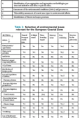
Table 2: Selection of environmental issues relevant for the European Coastal Zone
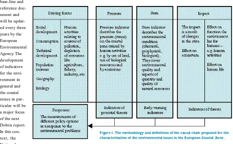
framework was fur ther elaborated resulting in the scheme depicted in
Figure 1.
Theimpact box is used to identify changes in the eco-system, human functions and human health. Due to the resilience of the ecosystem, changes in environmental pressures do not always result in changes to the ecosys-tem. Moreover, changes in the state of the environment are so gradual that changes in the system are difficult to identify, and there is a time lag before ecosystem changes become visible. The state box contains environmental
(geo-physical, chemical and biological) variables which describe the character-istics and conditions of coastal zones. The pressure box lists stresses on the
environment in the form of direct pres-sures, such as emissions. The driving forces box identifies the human
activi-ties and economic sectors which pro-duce the pressures. Explanation of the contribution of a driving force to an environmental problem will be more understandable to policymakers than simply identifying the raw pressures. This information is also necessary to develop adequate policy measures, the response.
This framework can be combined with an environmental issue/ thematic approach in order to identify environ-mental problems. This approach orga-nizes and structures environmental indicators by theme or environmental issue.
This combined approach creates a structure that links human activities in a logical way to environmental issues in the coastal area. The logical chain operates in two directions: the possible pressures lead to possible impacts, and in the other direction, human activities identifiably contribute to existing problems or impacts.
For the actual application of the framework, a step-wise approach has been adopted.
Steps 1 to 4 result in a preliminary
definition of data requirements to cal-culate the pressure and state indicators of selected issues. These issues indicate stress or problems to which the system is exposed and are directly related to
human activities, the targets to which policy is directed. Steps 5 to 7 concern the assessment of the specific environ-mental conditions and vulnerability of
European
Coastal Zone
(continued from page 3)Table 1: A step-wise approach to develop a set of environmental indicators and to assess the quality of and pressures on the
(e.g., national, regional and local), context (political, socioeconomic and cultural), reef uses (fishing, mining, tourism/ recreation, etc.), and gover-nance (institutional frameworks, knowledge bases, plans, implementa-tion, monitoring and evaluation).
A brief description of some of the indicators included illustrates the types of information sought and RAMP’s potential relationship to monitoring and evaluation of coral reef gover-nance. For example, at the national level it is important to obtain informa-tion on variables such as populainforma-tion, population growth, significance of coral reef uses (e.g., products extracted, tourism), unemployment, literacy and balance of trade. High levels of unem-ployment combined with rapidly increasing population and pressures on
by Richard B. Pollnac
A
dequate monitoring and evalua-tion of the impacts of coastal zone management projects is essential as a means of providing the informa-tion necessary to both adjust ongoing projects and formulate new ones. Unfortunately, in most cases, by the time it is recognized that some sort of monitoring and evaluation is needed, it is too late to obtain the baseline data necessary for adequate comparisons. ReefBase, a global database on coral reefs developed by the International Center for Living Aquatic Resources Management (ICLARM), could serve to provide this important baseline in-formation with respect to coral reefs.In addition to information concern-ing physical and biological conditions of coral reefs, ReefBase also includes indicators of sociocultural aspects of human populations associated with the reefs. Indicators of coral reef-related human behaviors, as well as related political, socioeconomic and cultural variables can be useful in monitoring and evaluating the impacts of coastal management projects involving coral reefs. Adequate monitoring and evalua-tion requires appropriate, standardized indicators in order to make reliable assessments of changes associated with management efforts as well as to eval-uate the relative importance of the multitude of variables thought to influ-ence success of coastal management. The indicators were identified as a part of a project entitled Rapid Assessment of Management Parameters (RAMP) which was directed at providing socio-cultural information to be integrated with ReefBase.
RAMP was designed specifically to develop a meaningful, standardized approach for social, cultural and eco-nomic surveys of reefs. RAMP involved the University of Rhode Island’s Coastal Resources Center in
collaboration with ICLARM in con-ceptualizing and field testing an effi-cient survey and database approach to assessing the human aspects of coral reef ecology and management. The purpose of RAMP was to provide a pared-down set of indicators covering the range of human factors potentially impacting coral reefs. Towards this end, available literature concerning aspects of human activities impacting and potentially impacting coral reefs was reviewed for the purpose of devel-oping a guide for information acquisi-tion and subsequent coding for inclu-sion in ReefBase. The review resulted in indicators that are organized
accord-ing to proximity to the designated reef (continued page 6)
Monitoring and Evaluating
Coral Reef Management
land resources can result in movement by people into the fishing industry as employment of last resort, or affect people’s inability to move out of the fishery due to lack of appropriate alter-native occupations–all factors that con-tribute to overfishing with potentially negative impacts on reef ecosystems.
Literacy levels impact employment alternatives as well as ability to receive information concerning reef conserva-tion issues. Low per capita Gross Domestic Product, political unrest and unfavorable balances of trade can result in environmentally inappropriate deci-sions regarding governance of reefs. Additionally, there is a clear conflict between poverty and sustainable devel-opment. Poverty results in a situation where immediate access to a resource such as a coral reef becomes more important than future declines in that resource.
Indicators from the regional context are also significant. The regional context is defined in RAMP as the watershed area impacting the reef. In this area it is important to determine land use practices (e.g., farming, industry, for-estry), as well as population and employment. The employment indica-tors, along with regional population and land use, can be used to evaluate the potential for changes in occupation structure resulting from reef manage-ment initiatives. For example, one could estimate the regional potential for ab-sorbing labor displaced from a specific sector. If the only sources of livelihood are farming and fishing, and if popula-tion pressure on the land is already high, then management initiatives re-sulting in displacement of fishers are unlikely to succeed.
The local context, as used here, in-cludes the onshore area inhabited by reef users as well as the reef itself. Indicators include aspects of reef use (e.g. , fishing, mining, tourism and species extracted or used for tourism),
local demography and settlement pat-terns (including population structure, occupations, social and political orga-nization, existing institutions, etc.). In-formation on population, occupations and their relationships with reef use are clearly related to management of the resource and should form part of any monitoring and evaluation effort. Governance indicators (both tradi-tional and statutory) include use rights and regulations governing all aspects of reef use, as well as aspects of user knowledge of reef resources which are important in understanding existing use patterns and potential reactions to management measures and user educa-tional programs. Ecological knowledge of users is a factor increasingly recog-nized as both influencing receptivity to and providing information significant for governance, use rights and actual management efforts (traditional and/ or official). National and local governance setting indicators are justified by the fact that they influence the develop-ment, implementation, monitoring and enforcement of management efforts. Descriptions of use rights are fundamental to evaluating existing or potential management efforts. Numerous researchers have related territoriality to success in management efforts. Finally, description and assess-ment of existing manageassess-ment efforts (both traditional and statutory) pro-vide a benchmark for assessing the degree of control over the role humans play in the reef ecology, as well as information thought to be essential to development of appropriate manage-ment schemes.
In all cases, the ideal is to enter data at the most precise level of measure-ment appropriate to the variable under consideration to facilitate statistical analyses. It is understood, however, that the availability of information or funds to gather information may result in varying levels of precision. The data-base, therefore, accommodates different levels of measurement, and provides indicators of the methods used to facil-itate appropriate interpretation of the
data. For example, relative importance of a specific coral reef fish for fisher income could be based on landing sta-tistics and initial selling price by species. The landing statistics and value could be analyzed to determine the percent-age of income derived from a particu-lar species. This value (percent contri-bution to fishery income) would be the most precise measure of relative importance of a certain species for fisher income.
Alternatively, where landing or marketing statistics are unavailable, the figure could be based on key informant interviews where fishers and/ or fish sellers would be asked to list and rank the five highest income-generating types of fish they harvest. In this case the level of measurement would be relative rather than a precise metric measure. Nonetheless, the measure-ment can still be used in statistical analyses. Sometimes information sources will use concepts such as low, medium, high or some variant of these concepts to indicate a level of impor-tance, use, etc. Despite the fact that these are evaluative concepts, not numbers, they can be converted to numbers signifying different levels of value. In some cases the source of information may only indicate several species as being important with no ranking. Here we have a simple dichoto-my where a given species is either important or unimportant–a simple yes/ no, limited choice. This type of information is better than none at all, and it can also be used in statistical analyses; hence, accommodation is made for it in the database. Each indi-cator, as appropriate, will have fields for different levels of measurement. Since information will be derived from different sources, using varying meth-ods, it is important to have fields spec-ifying information sources, dates and methods used so that users can decide whether or not the information is of sufficient timeliness, validity, reliability and/ or precision for intended analyses.
The indicators and guide have
Coral Reef
Management
(continued from page 5)by Ian M. Dutton
P
erformance monitoring is now high on the agenda of many pub-lic agencies–a change which many commentators suggest is both overdue and essential if increasingly scarce pub-lic sector resources are to be used effi-ciently and effectively. But, as with so many management questions, it is dif-ficult to determine what is efficient or effective.Historically, such judgments have been made intuitively
or by relatively sim-ple measurements of inputs and outputs. Such bean counting is, however, no longer sufficient to justify the often con-siderable investments of private and public funds or to enable decisionmakers to determine where to allocate resources among competing groups.
Decisionmakers, taxpayers and other stakeholders in pub-lic programs have, quite rightly, begun to demand an
exami-nation of evidence on which claims about program effectiveness are based. As a consequence, the misguided assumptions of causality between pro-gram inputs and impacts (or out-comes) are now being questioned in unprecedented ways. That process of questioning has led to widespread re-examination of concepts that coastal managers once thought they under-stood, or at least were addressing in an adequate manner.
The coastal management communi-ty, particularly those involved in pro-grams which depend primarily on
pub-lic funds, are now being challenged to account for performance in ways unheard of five years ago. Integrated coastal management literature offers little help to the coastal resource man-ager who now has to write a perfor-mance monitoring plan before even beginning the process of planning how to allocate coastal resources amongst competing users. The literature on performance assessment, monitoring methods and outcome tracking fills a very small portion of most coastal
man-agers’ bookshelves compared to the many books and articles on resource survey techniques, spatial planning, con-flict resolution and public education.
The rapidity of this shift in emphasis of funding agencies has caught many coastal managers by surprise, but there is now a commendable promptness among many groups to become in-volved in several aspects of monitor-ing–from the comparatively simple act of determining intended outcomes to the more complex act of measuring progress towards attaining those out-comes. These are, as most newcomers
to monitoring are finding, not inde-pendent or insubstantial exercises. The mere act of defining measures for monitoring is extremely enlightening to many organizations. W hen these groups must define desired outcomes and the appropriate benchmarks to measure those outcomes, their confu-sion about their goals is revealed and must then be addressed.
Performance monitoring is necessary, and it is productive even in its early stages. But can performance monitoring actually improve programs? Is it simply another fad in the cycles of public reform, or does it possess inherent value for managers and management
organizations?
These are not new questions for pri-vate sector organizations, which have been grappling with similar information needs. There is a body of evidence that suggests that those organizations that actively pursue performance monitor-ing are likely to be more resilient than those that do not.
The coastal management community can learn much from that experience, particularly given the current high level of confusion in many agencies about techniques of monitoring, and
miscon-Performance Monitoring–
Something Old is New Again
(continued page 8)
ceptions about the costs and benefits. O ne such area is the perception of performance. Many companies experi-ence difficulties in both developing adequate measures of consumer satis-faction with products and in linking measurement of performance with corrective action.
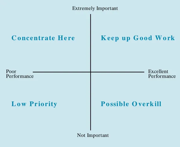
To assist in this situation, marketing researchers developed a technique known as Importance Performance Analysis (IPA). The technique asks
con-sumers/ clients to rate products on two scales – an importance scale and a performance scale. O verlaying these scales in grid fashion as shown in
Figure 1 below reveals the implications
for producers/ managers. The visual orientation of the Action Grid enables users to readily comprehend monitor-ing re-sults and to frame intervention options (for example, reallocation of effort from the “O verkill” quadrant to the “Concentrate Here” quadrant).
This relatively simple technique has been employed by resource use man-agers in recent years and appears to
have considerable potential in integrat-ed coastal management applications. For example, in studies of coastal pro-tected areas in Australia, the percep-tion of management performance by various groups of stakeholders was evaluated. In a study of a small rainfor-est reserve which has high conservation and recreational values, the six stake-holder groups surveyed included special interest groups (naturalists, volunteers, etc.), educators, adjacent landholders, recreational visitors, regional residents and coastal managers. Each was asked to assess the importance of various attribute/ service variables in the
reserve (views, access, crowding, lit-ter, drinking walit-ter, etc.) and to rate management performance in relation to that attribute/ service.
W hile the IPA ratings of the five client groups were relatively consistent on most attribute/ service variables, they differed significantly from the ratings of the coastal manager group. This difference was explained by more critical assessment of performance by clients and consumers, but is also at-tributable to different perceptions of service or attribute importance. It has long been understood that the
percep-tions of coastal managers are not nec-essarily the same as resource users. However this was one of the first stud-ies to quantitatively examine the sig-nificance of those differences. W hat is important from the example is not just that there were differences, but that the extent and nature of the differences (clearly visualized in the resultant Action Grid) offered benchmark rat-ings of management effectiveness and helped to define directions for im-provement of effort.
Following that study, IPA has been extended to other types of applications, including a trial application of the technique in measurement of the per-formance of coastal management con-sultants relative to predefined terms of reference. The resultant IPA grid gave an unambiguous basis for compar-ing client and consultant perceptions, for defining areas for reallocation of effort and for measuring performance over time.
W hile there are limitations to tech-niques such as IPA, their potential de-serves further examination, particularly as currently used suites of coastal resources management indicators are tested and refined. Experience in the private sector and in other non-resource-based areas of management activity suggest that performance monitoring is both worth the effort and will endure. Early indications from various coastal management programs that have implemented performance monitoring suggest that the effort to measure progress towards desired outcomes provides a considerable return on a modest investment. The purposes of monitoring, however, must be clearly defined and closely linked with the overall management cycle–otherwise, monitoring can be a costly and fruitless experience.
For more information contact: Ian Dutton, Coastal Resources Center -University of Rhode Island, Jl. Madiun No. 3, Menteng 10320, Jakarta Indonesia. Tel: 62-21-329-6424. FAX: 62-21-329-6423. E-mail:
Performance
Monitoring
(continued from page 7)Extremely Important
C o n c e n tr a te H e re
K e e p u p G o o d W o rk
Poor Excellent
Performance Performance
L o w P r io rity
P o ssible O ve rk ill
Not Important
by Nathaniel Emmert
M
any governmental agencies operate programs for years and spend millions of dollars without ever attempting to assess the impacts or doc-ument the status and trends of the sub-ject of their efforts. The result can be the loss of focus for the program, the inefficient use of financial and personnel resources, and the loss of public and political support. For the past several years, planning professionals at all levels of government, particularly environ-mental planners, have been aggressively working to redesign their policy plan-ning processes and build an intergovern-mental partnership to im-prove their joint public policy management skills by adding measurements of progress, increasing accountability and focusing on results.A major area of importance is the development of environmental and growth management indicator systems. Indicators are useful tools for a wide variety of management purposes, and the capacity of individual public organi-zations to develop policy is greatly enhanced by the availability of good indicator systems.
The multiple uses of indicators and the pivotal role they play in any serious attempt to improve public management have focused much attention on proce-dural and technical issues concerning the development of indicator systems at all governmental levels. International, national and regional conferences, and a variety of publications on indicators and indicator systems development have increased interest, especially among state and regional agencies. In 1990, only a handful of states were using in-dicators in any direct sense, and only two, Florida and North Carolina, had made any explicit attempt to systemati-cally develop and document a compre-hensive environmental indicator system. Federal agencies were only beginning to
develop explicit indicator systems. That has radically changed. There is now so much indicator work going on that the situation is almost chaotic. Nearly 30 states have developed or are finishing initial work on environmental indicators or closely related state-of-the-environment documents, and virtu-ally all states report they expect to undertake indicator development pro-jects in the near future. At the federal level, a number of interagency and intra-agency organizations are at work to develop indicator systems and, per-haps more importantly, to begin the process of redesigning federal environ-mental monitoring systems. A move-ment is just now beginning at the local level, and even at the community level, to use indicators.
The Florida Coastal Management Program (FCMP) provided national leadership by becoming the first state coastal program to develop an explicit indicator system when they developed the Florida Assessment of Coastal Trends (FACT 1995). This tool provided a comprehensive perspective of the important environmental, economic and social values associated with the coast. It also provided a means of evaluating Florida’s progress in protecting its coastal areas, a basis for making strate-gic decisions about programs and finan-cial resources, and information for other decisionmakers and the general public about coastal issues and prob-lems.
The FCMP contracted with the Florida Center for Public Management (FCPM) of Florida State University to assist in the design and development of this system. FCPM was charged with preparing a report containing a struc-tured collection of environmental, growth management, economic and social indicators that collectively describe the status of Florida’s coastal areas, portray the historic trends affect-ing coastal Florida, and project Florida’s coastal future.
The original FACT 1995 document represented the product of these activi-ties. Structured across its nine issue areas are 98 indicators that reflect im-portant issues affecting Florida’s coastal areas. These issues include: Impact of Growth in the Coastal Zone, Disruption of Coastal Physical Processes, Respond-ing to Coastal Threats and Hazards, Degradation and Restoration of Coastal Ecosystems, Managing Fresh Water Allocation, Sustaining the Human Uses of the Coast, Balancing Public and Private Uses of Resources, Preservation of Cultural and Aesthetic Resources, and Encouraging Public Awareness and Involvement. In 1996, the trends and conditions outlined in FACT 1995 were used as the foundation for the develop-ment of the first Florida State of the Coast Report.
FCPM’s current effort, the Florida Assessment of Coastal Trends (FACT 1997), is the first update and revision of FACT 1995 and represents a significant step forward in refining, refocusing and consolidating the original indicator sys-tem. The process that led to FACT 1997 included a number of improve-ments on the original indicator system. The entire system was comprehensively reviewed to identify strengths and weaknesses, and to assess its effective-ness in supporting issue and sub-issue areas. These assessments directed atten-tion toward new or substitute indicators for some areas and suggested deletion of others. Each indicator was individually assessed to make a judgment regarding its contribution to the effectiveness of the system. Proposed indicators with no data, and indicators with weak data or technical flaws, were dropped as formal indicators and better sources of data were substituted whenever they were discovered. FACT 1997 reduced the sys-tem to 80 indicators, but included in that number were seven new ones.
A variety of trends become apparent when viewing FACT 1997. O ver 60 per-cent of Floridians live within five miles of the coast, and Florida’s coastal counties are experiencing a growth rate over
Florida Assessment of
Coastal Trends
twice that of the national average. This population pressure is responsible for increased demands on virtually all nat-ural resources and ecosystems. Urban and cropland land cover are cat-egories that continue to increase, while marsh and forest lands decrease. Total freshwa-ter withdrawals are steadily increasing. Manatee deaths more than doubled from 1995 to 1996.
FACT 1997 is not without success stories, however. Infestations of the exotic plants water hyacinth and hydrilla are decreasing. The southern bald eagle population is making a strong come-back, as are reddish egrets and wood
storks. Seagrass acreage is increasing in most areas, as is the amount of land pro-tected as conservation land.
As better sources of data become available, the maintenance of Florida’s coast will be based on historic fact and informed projections. The ability to objectively view the conditions and trends occurring in coastal areas will give our leaders the tools necessary to plan and prepare Florida for a legacy that is a model for other areas.
For more information contact: Daniel Parker, Florida Center for Public Management. Tel: 904-644-2242. The Florida Assessment of Coastal Trends
(FACT 1997) is available on the Internet at:
http:/ / www.fsu.edu/ ~ cpm/ FACT97/ index.html. W ritten copies are avail-able from the Florida Coastal Management Program at 850-922-5438.
FACT
(continued from page 9)
I
n the river’s deep heart
a forked stick strains from the water
like the fingers of a Nile woman who,
last century,
touched them to her forehead,
then plunged them into rushing swiftness;
beads of sweat flying past her still,
stick folding under,
acquiescing.
O n the river’s still bank
footprints lead up the soil where
a family of ducks plodded last season,
perfect webbed fossils getting smaller,
smaller as water-droplets splash them,
muddy them, make them fall back,
get up again
and again.
O n the river’s sturdy log,
forming a bridge over water,
a friend
sits and shows me where
her father led horses.
W here she puts her feet in,
the currents curl her toes forward.
I look to her face–a smile of histories,
her eyes the color
of the river.
River Histories
Figure 1: Project Cycle
Linking Project Design,
Management and Monitoring
in ICM Projects
by Richard Margoluis,
Nick Salafsky and
Meg Symington
I
magine you have just been hired to be the project manager of a newly created coastal and marine biosphere reserve. Your first challenge is to facili-tate a process to design the reserve in a way that will help satisfy some of the immediate needs of the people who live in and around the reserve while ensur-ing its conservation for future genera-tions. In recent years, the area encom-passing the new reserve has been increasingly used for the expansion of family agricultural plots, shrimp farm-ing, and extraction of mangroves for fuelwood, charcoal production, and construction. Likewise, foreign fishing vessels have been actively fishing in the waters inside and around the new re-serve. As a responsible manager, you want to be able to target project activ-ities as efficiently as possible to address the major threats to the new reserve and you want to be able to demonstrate just how effective your interventions have been.So where do you begin? How can you be sure to facilitate the design of the project so that it has the greatest probability of having positive social and environmental impacts? How do you ensure that all relevant stakehold-ers are included in the project? How do you truly know if the project meets its objectives? How can you convince com-munity members and the groups fund-ing your project that your project has been successful? How can you be sure you will be able to learn from the results of project activities and modify and adapt them as needed? W hat type of information is most useful to you to make sure the project remains on target?
This situation and these types of questions are typical of the challenges
encountered by integrated coastal man-agement project managers. To answer these questions, an integrated coastal management project must set up a system for monitoring the impact of its activities. Monitoring is a vital tool that allows measurement of the im-pacts of a project and enables managers to make adjustments to their interven-tions so that objectives can be met–it is the key step in the process of adap-tive management.
Constraints to Monitoring and One Solution – BSP’s
M easures of Success Approach Despite the importance of monitor-ing there are often serious constraints that prevent projects from doing quali-ty monitoring work. Project staff often are so involved with day-to-day opera-tions that they may feel that they do not have the time or money to invest in monitoring. Likewise, field staff may believe that monitoring can only be done by experts or scientists and that they
themselves are not qualified to do the job. Finally, and perhaps most impor-tantly, some managers may simply feel that they do not know how to design comprehensive management and mon-itoring plans–that they are un-sure about what it is they actually want to be monitoring.
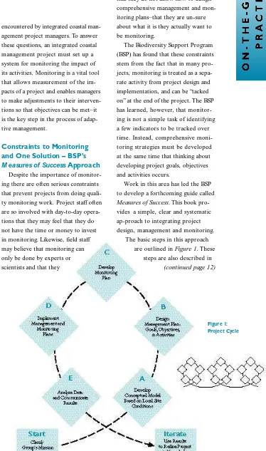
The Biodiversity Support Program (BSP) has found that these constraints stem from the fact that in many pro-jects, monitoring is treated as a sepa-rate activity from project design and implementation, and can be “tacked on” at the end of the project. The BSP has learned, however, that monitor-ing is not a simple task of identifymonitor-ing a few indicators to be tracked over time. Instead, comprehensive moni-toring strategies must be developed at the same time that thinking about developing project goals, objectives and activities occurs.
Work in this area has led the BSP to develop a forthcoming guide called
Measures of Success. This book
pro-vides a simple, clear and systematic ap-proach to integrating project design, management and monitoring.
The basic steps in this approach are outlined in Figure 1. These
steps are also described in
the following sections using work that BSP did for the Protected Areas of Central America, Coastal and Marine Component (PRO ARCA/ Costas) pro-ject as examples. The steps are drawn from a series of workshops at the four PRO ARCA/ Costas sites during which project staff, community members and non-governmental organization (NGO ) and government agency personnel developed complete draft Project Plans – conceptual models, management plans and monitoring plans (products of the first three steps in Figure 1) –
for their respective sites.
Start: Clarify Group’s Mission
The first step in any project is to determine who will be designing and implementing the project. This step is crucial when beginning any new pro-ject or collaborative effort. Conserva-tion efforts that give voice to the vari-ous stakeholders from the beginning are generally more likely to succeed and be sustainable. Expectations of participating institutions and individu-als regarding what the collaborative project will accomplish must be clear from the beginning. Project partners must find common ground and be sure they understand common goals to avoid serious misunderstandings that under-mine the project.
The strategic planning/ monitoring workshop in the PRO ARCA/ Costas project in Nicaragua represents a suc-cessful project initiation. Representa-tives from two local NGO s, govern-ment agencies, universities and four communities came to consensus on the overall purpose of the PRO ARCA/ Costas project in Nicaragua. Diamond A: Develop a Conceptual Model Based on Local Site Conditions
A conceptual model is a diagram of a set of relationships between certain factors that are believed to impact or lead to some target condition. It is
crit-ical to involve community members and include reliable site-specific data in the development of the conceptual model. The best way to develop a con-ceptual model is through a highly par-ticipatory activity where stakeholders discuss and negotiate the final diagram.
In the Gandoca/ Bocas PRO ARCA/ Costas site, for example, participants agreed that key factors included fishing, sea turtle hunting, pollution, sedimen-tation and tourism, which all influence the target condition defined as “the con-dition of aquatic resources in Gandoca/ Bocas.” The team wrote the key factors (32 in all) on sheets of paper and ar-ranged them on the floor as they dis-cussed each one and its relationship (represented by masking tape arrows) to the others. Using this approach, workshop participants were able to clearly identify priority factors that needed to be addressed in order to have maximum impact on the target condition.
Diamond B:
Develop a Management Plan
The management plan describes what the team will do to influence the target condition identified in the con-ceptual model. The management plan includes three project components: goals, objectives and activities. Goals
are general statements about the de-sired state that the project is working to achieve. Objectives are specific
statements detailing the desired accom-plishments or outcomes of the project.
Activities are the specific tasks or
actions designed to reach each of the project’s objectives. Measures of Success makes use of criteria lists to
help project managers distinguish and develop each of these components.
The following examples of goals, objectives and activities were devel-oped by participants of the PRO AR-CA/ Costas workshops.
G o a l
(from Nicaragua’s Miskito Coast):
■ To safeguard and sustainably manage the aquatic resources of our coastal
lagoons for the future well-being of our communities.
Ob je c t i v e
(from the Gulf of Fonseca):
■ After three years from the beginning of the project, there will be no new expansions of shrimp farms in the Chismuyo Bay W ildlife Reserve. A c tivity
(from the Gulf of Honduras):
■ Hold a competition among students in public schools to paint or draw pictures that promote the protection of the manatee.
Diamond C:
Develop a Monitoring Plan
The monitoring plan provides the structure for stakeholders to make sure their project is on track; it describes how information will be collected over time to measure project success. In the monitoring plan, specific indicators are developed for all project goals and ob-jectives, and the completion of project activities is recorded. The monitoring plan describes not only what data will be collected (indicators), but also how, when and by whom they will be collected.
The following example indicators were developed by workshop partici-pants for the goal and objective des-cribed for Diamond B above.
E x a m p le in d ic at o rs fo r g o al
(from Nicaragua site for one fish species, snook):
■ Total number of snook captured ■ Size of snook captured
■ Average weight of snook captured
E x a m p le in d ic at o r fo r o b je c t i v e
(from Gulf of Fonseca site):
■ Area (in hectares) of active or aban-doned shrimp farms
■ Area (in hectares) that have been cleared for future shrimp farms Diamond D:
Implement Management and Monitoring Plans
Linking Project Design
(continued from page 11)Evaluation of Coastal Zone Management
Initiatives in the Mediterranean
by Ivica Trumbic
T
he Mediterranean Environmental Technical Assistance Programme (METAP) has entered its third phase, marked by increasing commitment to integrated coastal management (ICM). The Mediterranean Action Plan (MAP) is also very active in this field, and there are a large number of ICM initiatives in the region. As efforts to achieve sustainable development in the Mediterranean enter their third decade since the signing of the Barcelona Convention, it is essential to discover the best mode of investing new re-sources. To help guide the next round of investments in ICM proposed under METAP, a selective review of ICM ini-tiatives was carried out.The main objectives of the evalua-tion are:
■ To identify those ICM initiatives which have been successful in meet-ing project objectives and to docu-ment the basis for success in each case.
■ To identify constraints to establish-ing or advancestablish-ing ICM initiatives in countries which have attempted to do so.
■ At the regional level, to assess whether individual initiatives and the larger programs of which they are a part (particularly METAP and MAP) have created significant improvements in environmental conditions.
■ To outline the lessons learned from these initiatives which may be applied in the region and elsewhere. ■ To propose recommendations for
replicating successes on a larger scale. ■ To propose policy level
recommen-dations regarding the place and im-portance of ICM to the parties of the Barcelona Convention. ■ To inform METAP and MAP and
sponsors of other pending initiatives in the region of the results of the
study to help them focus resources on those activities which are most likely to have an impact.
The evaluation process took place in three phases. In the preparatory phase, the analysis of available documentation was performed, as well as a brief over-view of all ICM interventions in the region, the evaluation methodology developed, case studies selected, and a questionnaire for the national focal points for MAP and METAP prepared and distributed. In the second phase, the evaluation was performed through site visits, filling out the questionnaires and on-site evaluations. Three team meetings were organized in which the methodology was coordinated, evalua-tions were made, and drafts of the case study reports and the joint report were prepared. During the third phase, the dissemination of results will occur at meetings and workshops attended by the main stakeholders. The docu-ments will be presented to METAP and to the Contracting Parties to the Barcelona Convention in a meeting scheduled later this year in Tunisia.
The expert group began by identify-ing 30 programs, plans and projects that qualified as coastal management projects on the basis of project docu-ments compiled from METAP, MAP or other sources. Those included only initiatives that, by their territorial ele-ments and contents, clearly fell under the category of ICM. The next step in the group’s work was the selection of a smaller group of projects to be consid-ered as case studies. The criteria used were representation, policy focus and organization of intervention.
The team selected nine case studies that fell within the global category of ICM inter ventions. That number was deemed feasible, as the experts would be able to visit those areas, analyze them thoroughly, contact the relevant stakeholders, and fill out and evaluate the prepared questionnaires. The
fol-lowing case studies were selected (brackets indicate the program source): ■ The Coast of Albania (CAMP and
METAP);
■ The islands of Cres and Losinj in Croatia (METAP);
■ The Rhone River Basin - the coastal part of France (national);
■ The Island of Rhodes in Greece (CAMP and METAP);
■ The Coast of Israel (national); ■ The Coast of the Liguria Region in
Italy (national);
■ The Area of Al-Hoceima in Morocco (METAP);
■ The Tunisian Coastal Protection Agency (METAP); and
■ The City and Bay of Izmir in Turkey (CAMP).
Using the evaluation procedure, the team attempted to determine, as sys-tematically and objectively as possible, the relevance, effectiveness and impacts of program, plan or project activities in the light of their objectives. The evaluation framework contains a num-ber of key dimensions. These are the boundary lines within which an evalua-tion procedure is being carried out. Three key factors in the evaluation process were performance, integration and sustainability.
The dimension of performance refers to the extent to which the inter-vention has successfully fulfilled its objectives. The extent of success or failure can be measured in multiple terms: in measurable outcomes (e.g., the number of water connections or kilometers of roads), and in non-mea-surable ones (e.g., changes in attitudes or awareness, or strengthening of the institutions). It is also important to distinguish between factors that are the result of the intervention itself (which might depend on the internal consistency of the goals and objectives of the initiative, or the scope of the project with regard to the problems in the area concerned) and those that originate in the wider context where
Evaluation of Coastal
Zone Management
(continued from page 13)
the program, plan or project operates, and which might affect the performance of the initiative (e.g., inadequate inter-ministerial coordination or lack of plan implementation mechanisms).
The dimension of integration refers to the level of horizontal or ver tical inter-linkages achieved among sectors, planning inter ventions or administrative levels in the area concerned. Distinction is made between integration among
sectors, the environment and the socio-economic context, the various levels of government, and the level of participa-tion among gover nment instituparticipa-tions, the private sector, nongover nmental organizations, and the general public.
The sustainability dimension deals with the follow-up prospects of the in-itiative. It shows whether the initiative has the potential for continued effects after the life of the project, either in the for m of a mechanism directly built into the initiative, or in the for m of a context that will allow long-ter m
implementation of the initiative’s pro-posals, i.e. beyond the original life of project funding. A distinction can be made between the financial aspects (whether an adequate financial system has been put in place, or whether the linkages have been established with other policies, programs or investments beyond the immediate scope of the initiative), the institutional aspects (whether adequate institutional system exists to implement the initiative’s pro-posals) and political aspects (whether there is enough political commitment for implementation).
Based on the above dimensions, the early find-ings show the following results:
Performance
. More than half of the case stud-ies were judged successful in that they fulfilled most of the stated objectives. In those which were consid-ered par tially successful, not all of the activities planned were perfor med. Another criterion in assessing the case studies’ perfor mance is the mea-sure of positive effects they have produced. It is clear that the very fact that the projects were able to exist in cer tain areas was enough to produce some results, including improve-ment of the institutional capacity or environmental awareness.Integration
. This factor is perhaps the most representative of the success of ICM implementation in the region. It is an objective which is very difficult to achieve, since not all the methodolog-ical questions have yet been answered, and the most appropriate tools and techniques for integration have not yet been developed. More than half of the inter ventions have resulted in mediocre success in achieving integration between the various sectors. These aremainly projects comprised of a larger number of often unrelated or remotely related activities. In these, the sectoral integration achieved was lower than that of the projects covering a smaller number of sectors. The question of gover nance and par ticipation is a weak point in all the projects, par ticularly with regard to par ticipation of the general public. Many of the projects stated that par ticipation was one of their objectives, but in practice par tici-pation has been limited to the repre-sentative bodies only, and sometimes not even those groups are involved.
Sustainability
. This is the crucial point of the project’s implementation. Most of the cases have poor financial prospects. In only a few cases could the commitment by the authorities to financially suppor t the implementation of the project proposals be identified. Projects in more developed countries were more secure in this way. The pros-pect of an investment project to follow immediately after the completion of the documentation phase also indicated financial security–again this situation was more typical in developed coun-tries. Overall, the financial sustainability could be assessed as average. Institu-tional and political suppor t, however, indicated growth in the sense of owner-ship of the projects. This may be an encouraging sign, and if par ticipation levels could be increased, potential investors could be attracted and the prospects for financing the follow-up proposals might improve. Improve-ments in the environmental situation and resource use practices (with in-creased environmental awareness and education) and other outcomes of ICM projects could follow.For more information contact: Ivica Trumbic, Priority Actions Programme Regional Activity Centre (PAP/ RAC), UNEP Mediterranean Action Plan, Kraj Sv.Ivana 11, 21000 Split, Croatia. Tel: + + 385 21 34 34 99. FAX: + + 385 21 36 16 77. E-mail: ivica.trumbic@ ppa.tel.hr.
ICOMIS - A Modeling Tool for Better Decision
Making on Coastal Zone Development
by Marc Staljanssens
I
CO MIS is a geographic-based, policy modeling tool developed to assist decisionmakers in selecting the best coastal zone development alternatives from a number of feasible choices on the basis of pre-defined priorities. Sensitivity analysis capabilities of the decision support software allow for the simulation of “what if ” scenarios. Basic research on the ICO MIS concept was carried out in Guinea and Thailand, and a successful pilot project took place in India.ICO MIS can be applied at the na-tional or local level. O n a local level, or in the case of small island countries, the whole ICO MIS system can be PC-based. Requirements for use of the ICO MIS tool include:
■ Data input, storage, retrieval and management utilities (database, spreadsheets);
■ A remote sensing/ geographic infor-mation system;
■ Various expert systems and model-ing utilities;
■ A multi-objective decision support software;
■ Data output and presentation utili-ties (map maker, graphs and chart drawing); and
■ A user interface.
The logical steps in the application of ICO MIS are:
1. Problem definition. The nature of the problem typically is a conflict of interests such as the expan-sion of shrimp culture in an area of mangrove conservation. Since decisions in these matters are urgently required, ICO MIS is problem-oriented rather than comprehensive. An inventory of the problems will determine informa-tion needs.
2. Definition of the coastal zone. An important requirement for the setting of an effective ICO MIS is
the clear definition of the extent of the coastal zone. From both management and scientific viewpoints, the extent of the coastal zone will vary according to the nature and extent of the prob-lem and the resources considered, and be limited by administrative or politi-cal boundaries. In definition of the limits, it is important that all features and factors that influence the manage-ment and developmanage-ment of the coastal zone be included.
3. Assessment criteria. As-sessment criteria specific to each policy objective are chosen to evaluate the degree of achievement of policy mea-sures. They are chosen in roughly equal numbers in order to avoid introducing a bias in the multi-criteria analysis.
4. Sustainability analysis.
Existing or planned activities are iden-tified and formulated on the basis of the policy measures. Specific biophysical and social/ economic requirements and limitations correspond to each activity and are matched to the resource quali-ties. Not only is the existing situation considered but also the impact of planned policy measures and activities is simulated, and the areas of conflict identified.
5. Formation of policy alter-natives. Policy measures guide development toward the fulfillment of objectives related to integrated coastal management. To be realistic, the for-mulation of the various alternatives must take all relevant objectives and corresponding measures into account as these will determine a combination of activities for each alternative. Modeling is a useful means, for exam-ple, to include estimates of trends in autonomous developments in the alter-natives, or a prognosis of the effects of a planned policy measure.
6. Policy schemes. Various policy schemes are formulated, each putting emphasis on a policy objective such as resource conservation or
sus-tainable development. Criteria are given a priority ranking for the attribu-tion of weights. Weight is attributed to the criteria by pairwise comparison (analytical hierarchy process) and weight sets are designed to illustrate policy objectives. This priority ranking is applied in various ways to account for the possible variability in priorities.
7. Comparison of alterna-tives. The comparison of policy alternatives is performed by multi-criteria analysis. A simple weighted sum often gives satisfactory results in handling both quantitative and
qualita-tive criteria. The different weight sets offer the possibility of expressing the variability related to the different policy objectives and thus to compare alter-natives on a realistic basis. Moreover, estimates of the potential effect of a policy measure, or suggestions for the design of new policy measures, can be gained from the outcome of the sensi-tivity analysis performed on a weight or effective interval. The final result is an ordinal ranking of the alternatives.
For more information contact: Marc Staljanssens, ICOMIS, Pelmolenstraat 78, NL 7511 SC Enschede, The Netherlands. Tel: 31-053-4-319-288. FAX: +3153-4-311-922.
by Kem Lowry, Nirmalie
Pallewatte and A.P. Dainis
I
n the early 1980s, Sri Lanka devel-oped a national coastal management plan and began implementing a permit system in a 300-meter (m) coastal zone. The first generation management effort was designed primarily to reduce coastal erosion. More than 2,700 coastal per-mit applications, primarily for houseconstruction and sand mining, were processed in the first 10 years of the coastal program. The combined effect of the regulatory program, an exten-sive program of public education and the construction of some coastal pro-tection works, resulted in a substantial reduction in rates of coastal erosion.
In the early 1990s, Sri Lanka’s Coast Conservation Department (CCD) undertook a review of the coastal man-agement program. Working with the University of Rhode Island’s Coastal Resources Center, the CCD developed a report, Coastal 2000: A Resource Management Program for Sri Lanka’s Coastal Region, which outlined a
broader approach to coastal manage-ment. O ne of the key recommendations of the report was a call for the design and implementation of Special Area Management (SAM) plans “to be imple-mented at specific geographic sites of ecological and economic significance.”
SAM plans are conceived as a
bot-tom-up strategy for managing coastal resources that complements the exist-ing top-down regulatory approach in Sri Lanka. They allow for intensive, comprehensive management of coastal resources in a well-defined geographic setting (as contrasted with a use-by-use, regulation-by-permit approach). Participation by community residents and stakeholders in planning and man-agement is central to the SAM con-cept. Most advocates of this concept see government agencies playing a variety of roles in SAM planning and management. Government agencies serve as catalysts, or facilitators, that help organize communities to engage in resource management and provide technical support, as mediators to help balance competing demands in resource management and as partners of com-munities engaging in co-management with community groups.
In 1991, the CCD designated two SAM sites to begin planning: Hikkaduwa and Rekawa Lagoon. Hikkaduwa is a tourist destination set-tlement about 100 kilometers (km) south of Colombo. Small and medium-sized hotels, restaurants, bars and shops line both sides of the 4-km coastal highway bordering the Hikkaduwa Marine Sanctuary. Urban runoff, untreated sewage discharge, sedimentation of the reef, wastes from boats, and near-shore conflicts among boats, swimmers and other activities threaten the popularity of the town as a tourist destination. Rekawa, on the other hand, is a rural lagoon environ-ment in which coral mining, competi-tion among fisherfolk, interference with natural flushing of the lagoon and other uses have degraded the reefs and the lagoon and threatened the livelihood of the fisherfolk living around the lagoon. Beginning in 1992, CCD staff and representatives from the Coastal Re-sources Management Program (CRMP) began the process of SAM planning at
both sites. Government officials in selected agencies at the national level were contacted, and their interest and support was solicited. At the same time, CCD and CRMP staff began to work with community organizations to iden-tify groups with whom it might be possible to undertake identifying com-munity perceptions of resource man-agement problems and priorities. O ver the next three years, government offi-cials, community groups and interest group representatives identified priori-ty resource management issues and technical questions. Special Area Coordinating Committees, composed of both community representatives and government officials, were established at both sites. Technical studies were commissioned and environmental pro-files were developed for each site. Re-source management issues and strate-gies and identified for both sites and compiled into SAM plans. These plans were both adopted by their respective coordinating committees in 1996.
In late 1996, the CCD, the CRMP and the Sri Lanka U. S. Agency for International Development office com-missioned an evaluation of the SAM planning and management processes at the two SAM sites. An assessment team, composed of a government official and a university professor from Sri Lanka,
and a foreign coastal management spe-cialist, visited the sites. They inter-viewed government officials, user group representatives and residents and prepared an interim assessment of the two SAM programs.
W hile there are a variety of evalua-tive frameworks that might be used to assess the progress of the two Sri Lanka SAM programs, eight criteria
devel-Assessing Sri Lanka’s Special
Area Management Projects
Glass-bottom tourist boats and commercial fishing boats compete for space in Hikkaduwa.
oped by the Coastal Resources Center for assessing the governance of coastal management programs have been used to frame this brief summary:
■ Strategic decisionmaking. ■ Participation.
■ Integrated approaches and methods. ■ Learning and adaptation.
■ The role of science. ■ Capacity building.
■ Matching objectives to the capabili-ty of the institutions responsible for their implementation.
■ The policy cycle as a road map to the formulation of an ICM program. Strategic decisionmaking, in the Coastal Resources Center framework, refers to the degree to which govern-ments are able set priorities among coastal environmental problems, iden-tify causal processes, and design effec-tive and politically acceptable manage-ment interventions. In the case of the Hikkaduwa SAM plan, preventing the further degradation of the marine sanctuary was seen as the key problem. O il wastes from fishing boats anchored in the sanctuary and an excessive num-ber of glass bottom boats used to trans-port visitors to view the reef contribute to the degradation and depletion. Hence, the management emphasis has been on enlarging an existing fishing harbor to accommodate boats current-ly anchored in the sanctuary, and working with glass bottom boat opera-tors to design a cooperative agreement limiting the number of boats viewing the reef at any one time. These initia-tives are viewed as the most strategic interventions for SAM success.
At Rekawa, a misdesigned causeway blocking circulation in the lagoon, deterioration of the reef due to coral mining and over-fishing in the lagoon were viewed as key problems con-tributing to the larger problems of resource degradation and community poverty. Improving lagoon circulation, developing fishing management agree-ments among lagoon fisherfolk and prohibiting coral mining were viewed as important–and feasible–first steps in
organizing the community and improv-ing the state of community resources as initial efforts in improving the living conditions of Rekawa residents.
The degree and quality of partici-pation among those affected by the development and implementation of SAM projects is a second criterion for assessing governance arrangements. Participation is a key element of the SAM process design. In the SAM processes in Sri Lanka, one purpose of involving local residents was to insure that important time and place infor-mation was identified. Time and place information–detailed data about site conditions–was needed regarding the willingness of glass-bottom boat owners to organize at Hikkaduwa. At Rekawa, identifying which families were engaged
in coral mining and how willing lagoon fisherfolk were to organize was critical. A second major purpose of participa-tion is to organize agreement regarding the nature, extent and causes of resource degradation problems, and to help create consensus regarding proposed interventions. Community meetings, workshops and other organi-zational activities were undertaken at both sites to help mobilize interest and support. These efforts resulted in gen-eral community agreement about the resource problems and proposed inter-ventions at both sites.
Integrated approaches and methods focus attention on the degree to which coastal management efforts integrate multiple agencies and programs, levels
of government and technical analysis. The SAM programs at Hikkaduwa and Rekawa are integrative by design. The plans for both sites were developed by multi-disciplinary teams working with community groups and national, provincial and local government offi-cials. The plans are based on regulatory activities, coastal development projects, research, monitoring and organization-al efforts undertaken by both govern-ment agencies and community groups. Implementation of the two plans re-quires the collaborative efforts of many agencies at all three levels of government. Coordinating committees at both sites are working to maintain a comprehensive approach to improving resource conditions.
Mechanisms for learning and
adapta-tion have been identified by the Coastal Resources Center as fundamental to coastal management efforts. The two pilot SAM projects at Hikkaduwa and Rekawa are examples of a learning strategy. They were undertaken to test the feasibility of community coastal management and, in particular, to assess the issues associated with the design and implementation of community-level management approaches. W ithin the projects, information for learning and adaptation is based on government monitoring of resource conditions, re-search undertaken by university schol-ars and private researchers, and detailed information provided by user groups, such as fisherfolk and boat operators.
(continued page 22)
Coral Reef
Management
(continued from page 6)been subjected to two field tests to determine their applicability to “real-world” information-acquisition situa-tions. Locations included a coral reef area in the Philippines with growing fishing pressure and budding tourism, and an overfished area in Jamaica with extensive and growing tourist, industrial and population pressures. Lessons learned in these applications were used to modify the original drafts on indica-tors and guidelines for data acquisition. These guidelines will be published by the University of Rhode Island’s Coastal Resources Center and ICLARM as a handbook to accompany those used for the biological and oceanographic data acquisition and coding methods.
RAMP and ReefBase, together, pro-vi